 |
||
| Home >Roads and Tracks of Ayrshire > Ayr CC - The Road Board |
|
|
The overall structure of local government that was set up under the 1889 Act was as follows: (1)1. Town Councils2. Royal BurghsParliamentary BurghsPolice Burghs (including Burghs of barony and regality)They were responsible for public streets, roads and bridges within the burgh, although under the 1878 Act (Section 47) burghs with a population under 10,000 could pass this over to the County. An Act in 1903 required a register of streets to be prepared and it is interesting to note that it allowed the placing of fencing for safety purposes, and the placing of posts in the carriageway for crossings. As an aside, a pedestrian crossing was installed in London in 1878. This had light signals operated by gas but it blew up on its first day of operation.3. County CouncilsThese took on the functions of the Commissioners of Supply so far as they affected roads and bridges, and took over the powers of the County Road Trusts formed under the 1878 Act. A County Road Board of thirty members was to be set up.4. District CommitteesSo far as roads are concerned, if a county contained more than six parishes, or if it was desired, there was a requirement to set up District Road Committees. In Ayrshire there were four District Committees dealing with highways, viz. Northern, Kilmarnock, Ayr, Carrick. Each committee had representatives from the County, from the parish councils, and from those burghs that had transferred their responsibilities for roads and bridges to the County Council.5. Parish CouncilsThey could make representations to District Committees or the County Council on obstructions to rights of way, and the repair and maintenance of public ways that were not roads.
6. Standing Joint Committee This approved capital works,
and works that involved the raising of loans.
|
||||||||||||||||||||||||||||||||||||||||||||||||||||||||||||||||||||||||||||||||||||||||||||||||||||||||||||||||||||||||||||||||||||||||||||||||||||||||||||||||


| County Road Board |
The County Road Board was set up on 13 February 1890 and the first meeting held on 1st March 1890. (2) The first task was to decide on administrative districts and membership for each of the sub-committees. Voting took place on two proposals:
a) 6 districts Ayr Irvine Mauchline Beith and Largs Kilmarnock Carrick
b) 4 districts Northern Kilmarnock Ayr Carrick
along
with an amendment proposing 5 districts viz. Ayr, Kilmarnock,
Cumnock, Southern, Northern.
The
second option was chosen, i.e., 4 districts. Each of
the sub-committees had 7 members plus the Convenor and
the Marquis of Ailsa as the Chairman of the late board.
He
was chosen to be the Chairman of the new Board. The
next meeting was taken up mostly with financial matters.
There is, however, an interesting complaint that the
Renfrew Roads Trustees had taken road metal from Carling,
Auchenharvie and Crosshouse quarries and damaged the
land nearby. They found no evidence to support this
claim.
There
is also a long report on a claim for damages from a
Mr Rennie who had been in an accident. Mr Rennie, who
travelled the county with groceries and hardware had
crossed a culvert and stopped at a gate a bit farther
on (57 feet) on a hill. When one of the boys who was
with him opened the gate the horse started to back away
and could not be stopped. The horse, Mr Rennie and the
cart fell over the bridge into the stream, which happened
to be in flood.
Rennie
claimed that as there were no parapets he was entitled
to compensation for injuries to himself and the horse,
and damages to the cart and the goods. Perhaps surprisingly,
the Board paid �17.10.0 in compensation.
The
Board continued in existence up to 1930 when it was
replaced by the Highways Committee and carried out the
usual duties connected with the construction and maintenance
of roads as detailed above.
| Roads |
The following section details roads which were removed from or added to the list of public highways during the life of the Road Board, i.e., up to 1930. (3) Some very short lengths of country roads (generally less than 50 metres) have not been included nor have streets in towns because of the large numbers of these. It is therefore reasonably comprehensive and gives a good overview of what roads were built and what roads were upgraded from the 1880's onwards. As in the source document, distances are given in yards.
 |
| Note: Not all parishes have entries |
| Ayr District |
Coylton
A new road, some 520 yards in length was built in 1885
from Hillhead on the Cumnock Road, to Coylton Manse.
A short stretch of 385 yards was built in 1886 from
the Craigens of Kyle Road, past Kerse Tilework, to the
Littlemill Road.
Dalmellington
A new road of 1 mile 310 yards was built in 1922 from
Patna Station, on the Ayr - Dalmellington Road. It ran
to the east.
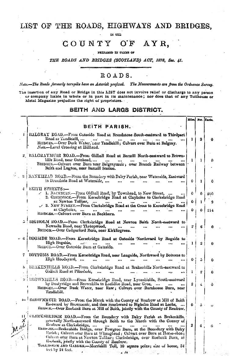
| Beith and Largs District |
One interesting feature of the returns for this district was that they gave the area of the land and houses for the tolls. Thus Burnhouse Toll on the Lochlibo Road was 20'2" x 16'6". Bunswynd Toll on the Kersebridge Road was 6.805 square poles and the house was 32'4" x 19'.
Dalry
In 1899 a one mile road (Windyedge Road) was added.
It ran from near Burntounges to Baidland.
Dunlop
In 1896 a new road, 7 furlongs long (the Halket Road),
was built between the Duniflat and Bradlie Roads.
Kilbirnie
There is an interesting reference in 1921 to new roads
in the Garden City, Kilbirnie reflecting the town planning
ideas of the time.
For the 1878 list of roads and bridges
for Beith parish, see here
| Girvan District |
No mention
| Irvine District |
Ardrossan
Just over half a mile of the Holmbyre Road near Duminastle
Castle was removed in 1891. In 1927 1� miles of the
Sorbie Road was removed from Stanley Road northwards
to a road leading to Craigpark Quarry.
Kilwinning
A footbridge across Lugton Stream near the Kilwinning
- Lochlibo Road was taken off the list in 1894. A new
bridge was built 5 years later.
Stevenston
In 1928, the Stevenston By-Pass was built. It ran for
just under one mile from Kellybridge Road east of the
town and rejoined it west of Stevenston.
| Kilmarnock District |
Dundonald
In
1887, a one mile link from the south end of South Beach
Road, Troon was made to the Mortonhill Road. The following
year a half mile stretch of road towards Barassie was
added from the Ayr - Irvine road (via Loans) as far
as the railway line. In 1904 a three quarter mile length
of road was built from Barassie Station towards Troon.
Also
in 1904, just over a mile of a new road, Loch Green
South Road, was built from Crosbie Church to the Troon
Road, near Monktonhill Farm. Although no date is given,
half a mile of road, the Gailes Cart Road, was built
from the Ayr - Irvine Road near Newhouse Farm to the
Military Camp. A further 560 yards were added in 1935.
Parkthorn
New Road, one mile in length, was built from near Parkthorn
Farm to the Irvine - Ayr Road near Gateside railway
bridge in 1907.
Symington
In
1884, three-quarters of a mile of the Catcraig Road
was removed from Helenton Mains to Benacres.
Riccarton
In
1908, a 350 yard stretch called Cadger's Road was added
from the Mauchline road up to Howie's Brickworks. The
name was changed in 1945 to Cessnock Road. Assloss Road
(� mile) was added in 1929. It ran from the Glasgow
- Kilmarnock Road at Wardneuk Farm via Assloss as far
as the Crooksmill Road. This latter road ran from Bringan
Mill Ford via Borland House to the main Glasgow road.
Stewarton
 |
 |
|
Details of roads and bridges for Stewarton parish as they appeared in the 1878 list. The first page shows roads as at 1878, the other page shows later entries (rtf file, txt file). |
|
There
is mention of a footbridge over the Lugton water near
the Lochlibo Road.
In
1927, Clerkland Sidehead road was added. It ran for
1� miles from the Dunlop - Stewarton Road near West
Clerkland generally north eastwards past High Goldenberry
to Kingston Road.
In
the same year, Cutstraw Road, one mile in length, was
built from near Kirkland Bridge in Stewarton to near
Bogside.
Kilmarnock
An iron footbridge was built over the Irvine near Struthers
Ford in 1885. In 1892 a bridge or culvert over the Mill
Lade on Milton Road and a wooden footbridge over the
Crawfurdland Stream on Crooksmill Highway (this ran
from the Braehead - Grassyards Road over to the Kilmarnock
- Flockbridge Road) were added.
Fenwick
Two hundred yards of the Old Glasgow Road from High
Fenwick to the cemetery were added in 1908. In 1915,
a 1� mile stretch of road was built from the Glasgow
road between High and Low Fenwick to join the Stewarton
Road near Gainford Farm. Gainhill Road was added in
1927. It ran for over a mile from the Glasgow Road at
Townhead via Little Fenwick to the Stewarton Road.
Galston
In the list of original roads, the Old Strathaven Road
which had been superseded by the turnpike is mentioned.
It left this at Ladybrow and went via Laigh Newton before
rejoining the newer road. Lime Road was added in 1902.
It started just east of the Windy Wizzen (on the A71
near Loudoun Hill) and ran east to the county boundary
half a mile away. Two other roads were added in 1904,
viz. Lanfine Road from near Cross Tree Farm to Ranaldcoup
Bridge (2� miles) and Hollowhill Road from the present
A71 southwards towards the county boundary (5 furlongs).
A
bridge over the Haymouth Burn on Bullhill Road and one
over Burn Anne, again on Bullhill Road were added in
1892.
Loudoun
Gateside Road, I mile in length, was added in 1926.
It ran from Loudoun Kirk past Gateside and East Hungryhill
Farm to Alton Bridge on the A719. Burnfoot Road was
added in 1936 and ran for just over half a mile from
Muck's Bridge on Foulpapple Road westwards to Burnfoot
Farm and then towards Brocklees Farm.
| Mauchline District |
Auchinleck
That part of the turnpike from Muirkirk to Sanquhar
which ran through the parish was removed in 1884. It
was impassable and no traffic used it.
Knagshill Road was removed in 1892. It ran for � mile
from the Auchinleck - Ochiltree road over to the present
A76. Commonloch Road was added in 1926. It left the
Coal Road a quarter of a mile south west of Common and
ran past Stable Row and Ballochmyle Road for � mile.
Mauchline
One mile of the Haugh and Syke Road from Haugh Farm
to the railway bridge was taken off the list in 1924.
There was a ford over the River Ayr at Damhead on this
road.
Muirkirk
Details of the Sanquhar road are given. Two and three
quarter miles (in Muirkirk parish) were impassable.
It had belonged to the Cambuslang to Sanquhar Trust.
I was told years ago that French prisoners of war from
the Napoleonic wars were employed in building this road
and that the remains of the bothies where they lived
could still be seen beside the road.
 |
 |
on this road it may be one of the first "modern" roads
Sorn
A number of roads, all just over a mile in length, were
removed in 1891. These were the Auchinlongford Road
which ran from the Mauchline - Muirkirk Road, 3 miles
east of Sorn to Auchinlongford and Barrshouse; part
of Barsavenue Road between Nether Heilar and 
Map based on 1946 1" OS sheet for
Ayr and Kilmarnock. With thanks to Ordnance Survey.
Templandshaw (the stretch between Nether and Mid Heilar
was reinstated in 1929); and a mile and a half of the
Blindburn and Blacksidend Road between Brocklar and
Blacksidend and Blackside Farms. Currently Barsavenue
Road is a dead end which leaves the Sorn to Auchinleck
road just south of Sorn and runs due east for about
three miles.
Another was the Bogend and Kenstie Road which left the A76 a few hundred yards past the Catrine turn-off and looped south of Catrine through Kenstie and Bogend to the Catrine - Lugar Road. There was a ford at Kenstie and part of the road was not made. Heateth Road, also partly unmade, ran from the Dippol Burn Bridge (on the straight stretch of the A76 just before the roundabout at the north end of Auchinleck) over to Sorn Road north of the Academy. A stretch of road, three furlongs in length, to Merkland Farm, on the Sorn -Muirkirk Road was removed. Finally, the Mid - Heilar Road was removed. This linked the Muirkirk Road to the Barsavenue Road via a ford. Part of this road was unmade.
| Maybole District |
Kirkoswald
A stretch of one mile was added in 1888. It leaves the
A77 at the sewage works a few hundred yards south of
Kirkoswald and runs over to the Maybole to Culzean Road
(A719).
Maybole
There is a list of fords in Maybole District. In Barr
parish there was one at Dalgarva (1 km east of Barr,
NX285941) on the Gregg Road, and fords on the Bannan
Road through the Stinchar (5km sw of Barr on B734, NX234914).
In Dailly there was one through the Water of Girvan
between Old Dailly and Killochan Station, and one through
the Killochan Burn on the same road. There was another
at Hawkhill Farm Steading (all NS2200). In Kirkoswald
there were fords on the Drummochreen Road through the
Ghaist Glen Burn near Lochspouts at the boundary with
Maybole parish, and two fords near Craigdow Entrance
(all NS2805). There was a ford through Milton Burn on
the Wellholm Road (just east of Kirkoswald at NS247076),
and two on the Corriston Road through the Milton and
Merkland Burns (just south of Kirkoswald at NS241072).
Near Dinnymuck Farm Steading (halfway between Turnberry
and Girvan at NS 204022) there was a ford through the
Lady Burn. In Maybole there was a ford through the Capenoch
Burn, near Spring garden (3km due south of Maybole at
NS300070). A bridge was planned at the time of writing
(1883).
| Roads Legislation |
With
the development of the motor vehicle it became necessary
to introduce legislation to address the various problems
which gradually became apparent.
There
was great hostility towards the early motorists even
though these were few in number. There were complaints
about damage to the roads, dust and speeding. The speed
limit was set at 12 mph in 1896 and raised to 20 mph
in 1903 although it could be set at 10 mph in towns,
as for example in Largs in 1907. The Motor Car Act of
1903 also introduced driving licences and number plates.
Road signs were standardised in 1904.
When
the 10 mph speed limit for motor cars was introduced,
a Marcus Bain who was standing for re-election to the
County Council claimed in his manifesto that "the providing
of stop watches for the constabulary to check excessive
motor-driving was sanctioned on my strong recommendation."
(4)
Strawhorn
tells of how the police in Cumnock noted the time a
motorist left Cumnock and telephoned this to Sanquhar
allowing the police there to charge the man with speeding.
(5)
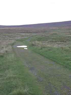
Perhaps surprisingly there were no agreed rules of the road in the sense of today's Highway Code - this was not introduced until 1930. Nor were there now obvious measures like road markings, traffic islands or traffic lights. The lack of these along with the rudimentary safety features on vehicles resulted in many road accidents, proportionately much more than today. The newspapers of the day have reports on some of these. Thus the Largs and Millport Weekly News mentions a cycle accident at Inverkip in 1900, a crash near Wemyss Bay in 1921 and a lorry running out of control on Haylie Brae in 1926. In 1909 there was an article on the dangers facing cyclists on the Largs to Dalry hill road. (6)
| Life on the Roads |
 |
| This photo taken north of Mauchline about 1900 gives a good idea of road surfaces before the widespread use of tar in the early 1900's. Photo from the Detroit Publishing Company's Views of Landscape and Architecture in Scotland - see thumbnails on Library of Congress site here. |
In
dealing with the actual roads it is quite easy to forget
what they were like for ordinary people to travel on.
Certainly in the late 1800s and the early 1900s many
would still have been unsurfaced and dusty in dry hot
summers though perfectly good for travelling on, albeit
a little bumpy.
Transport
was horse drawn with all sorts of carts and carriages,
some quite small and capable of a good turn of speed.
Some of these would have been tradesmen on a circuit
of farms and it would have been common to meet cows
and sheep being driven along the roads. In Tarbolton,
visiting football teams travelled by wagons (brakes)
to Woodside. (7)
Before the Great War, injured miners were taken home
in a box cart scattered with straw and Ayr County Hospital
had a horse-drawn ambulance that served country areas.
Carts were also used by locals to take away loads of
coal dug from the beds of the River Ayr and the Water
of Coyle.
Another
common sight was of gypsies. I have been told by someone
that he remembers going to Glengall (near Prestwick
Circuits factory on the Ayr - Dalmellington Road) on
a buggy in the 1920's and seeing a large group of gypsies
camped near there. They used old routes for travelling,
stopping at favourite locations. A couple of miles down
the road at the Dalrymple turn-off the hawthorn hedge
on the old road was planted here to stop them camping.
There
would have been a lot more people on foot - it was,
for example, quite common for school children to walk
several miles to their school. The occasional motor
car would have provided some diversion and perhaps irritation.
The roads were maintained by road menders, much along the lines of the sketch in John Buchan's 39 Steps. Heaps of stones, road metal, were kept in various locations called metal magazines and the 1878 List of Highways gives their locations. One was at the junction of Cumnock Road and Catrine Road; and was known locally as the site of the "breaking stanes." Mackie tells of a road mender, not too far from here, who because of his slight physique, always found it difficult to break the stones. (8) Some lads on a miner's strike stepped in when he started on a large pile of unbroken stone and reduced it to the required size by the end of the day. "There'll be four yards there," the grateful roadman said to a friend. "It would tak' me a lang while to dae that." Wallace's Cairn near Loudoun Hill was said "to have been much reduced in size by the depredations of the road menders. (9)
| References |
1. Whyte, Local Government in Scotland, William Hodge and Co, 1936
2. CO3/8/2/140, held in Ayrshire Archives
3. Taken from entries added to List of the Roads, Highways and Bridges in the County of Ayr prepared under Section 41 of the Roads and Bridges (Scotland) Act 1878
4. Mauchline in Times Past, ed. D I Lyell, Mauchline Burns Club, Countryside Publications, Brinscall, 1986
5. J Strawhorn, The New History of Cumnock, Cumnock Town Council, 1966
6. See Index 1877 - 1937 compiled by Largs and District Historical Society, ed. M B Hall
7. S Hay, Gathered Threads, Tarbolton
8. D Mackie, Ayrshire Village Sketches and Poems, Kilmarnock, 1896
9. John Smith, Prehistoric Man in Ayrshire, London, 1895
Next (Ayr County Council - The Highways Committee)
|
|