Despite
being less well-known than Wade, Caulfeild (d.1767)
was responsible for a much higher mileage of roads than
Wade, some 800 miles as against Wade's 250 miles. Caulfeild
was appointed Inspector of Roads in North Britain in
1732 with responsibility for road maintenance under
Wade.
Wade
left Scotland in 1740 and betweeen that date and 1745
the existing Stirling to Crieff road was improved and
the Dumbarton to Inverary road started under the superintendence
of Caulfeild - this latter road proving very convenient
for the Duke of Argyll.
But
for the '45, there may have been no need for further
road building but after 1745 various and generally repressive
measures were put in place including building a new
fort at Fort George. Work resumed on the Inverary road
and roads were started in 1748 between Stirling and
Fort William and Coupar Angus and Fort George though
they took several years to complete. The first road
ran by Callendar, Lochearnhead, Tyndrum, Bridge of Orchy
and the Devil's Staircase in Glencoe, the second by
Braemar, Corgarff and Grantown. It is clear enough that
there were pre-existing tracks along much of these routes,
some of which were used and improved by the military
roads but new stretches were made where deemed necessary.
 |
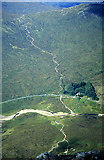
"The
Military Road on the banks of Loch Lomond" stone
lithograph drawn from nature by F.Nicholson, published
in Views in Scotland Drawn from Nature, 1828.
Image courtesy of ancestryimages.com
|
In
the 1750's the Inverary road was continued up to Dalmally
to link with the Stirling to Fort William road at Tyndrum,
with a branch to Bonawe. Another link was made between
these two roads between Tarbert and Crianlarich.
A
road had been proposed from Fort Augustus to Bernera
(where barracks had been built after the 1715 uprising
to guard a route from Skye) as early as 1746 but construction
only started in 1755 and took several years to complete.
The barracks were abandoned in 1790 but maintenance
seems to have ceased some time prior to that and the
road deteriorated very quickly being almost unusable
by the early 1790's.
The
road between Aberdeen and Corgarff was made between
1754 and 1756. Near to Aberdeen existing roads were
used and upgraded but further west new stretches were
made although 9 miles had deteriorated so much that
a new road had to be made in the 1790's. The road was
maintained by local statute labour.
 |
| Commemorative stone
at the Well of the Lecht on the Braemar to Fort
George road. It reads A D 1754, five companies the
33rd Regiment, right hon Lord Charles Hay Colonel
made the road from here to the Spey. Click for larger
image. |
Another
road ran from Aberdeen by Huntly to Fochabers close
to the Moray Firth. Again much of the work was improvements
rather than new roads. A branch went from Huntly to
Portsoy. Also
running to Fochabers was a road from Fettercairn by
the Cairn o'Mounth and Huntly, again improving existing
roads.
There
were also a number of link roads: Coupar-Angus was linked
to the two Wade roads at Dunkeld and Amulree and there
were several in the Aviemore/Grantown area. The Stirling
to Dumbarton route linked two important garrisons and
there was a short stretch of road connected with a garrison
at Inversnaid. A few of the roads date from after the
time of Caulfeild, for example the road from Stirling
to Dumbarton.
As
time went on there was increased co-operation with the
county authorities and, as Taylor shows, the history
of particular roads could be quite complicated where
for example statute labour might be used along with
working parties of soldiers, or the army contributed
to the cost of a road or bridge. By the late 1700's
some of the military roads had fallen into disuse and
others were replaced by good statute labour roads or
new turnpikes. From 1803 onwards, the Commission for
Highland Roads and Bridges also improved a number of
the roads.
Viewed
as a whole, it is remarkable just how closely the modern
road network in the Highlands is based on the military
roads (and their predecessors): the A9 to Inverness
and the A82 to Fort William being just two. While the
circumstances of their origin and their effect on
Highland culture might have been unhappy there is no
doubt that they had a significant impact on the development
of the Highlands at the time.
The
Roads
 Stirling
to Fort William Stirling
to Fort William
 |
 |
 |
| The
road at south end of Loch Lubnaig |
Glen
Ogle |
Glen
Dochart |
The
road, constructed between 1748 and 1753, ran first to
Bridge of Allan on the Crieff road that had been completed
a few years before and then ran to Doune partly through
the policies of Keir House and partly on the B824. From
Doune it had much of the line of the A84 as far as Callendar.
From
Callendar it ran through the Pass of Leny where a short
stretch can be seen, then up the side of Loch Lubnaig
to Lochearnhead. Again, stretches of the road can be
seen south of Lochearnhead.
Once
it reached Glen Dochart it ran for a couple of miles
on what are now farm roads past Wester Lix to Ardchyle
and followed the A85 line to Crianlarich and Tyndrum.
It is joined by a link road from Loch Lomond just west
of Crianlarich.
 |
| The old Telford road between
Bridge of Orchy and Forrest Lodge. Beyond that point
it is used as the West Highland Way. |
From
Tyndrum it went to Bridge of Orchy by what is now known
as the Old Glencoe Road. This was a Telford road made
in the early 1800's but closely based on the military
road. Today the A82 in this area, built in the 1930's,
has a different line from the other two roads.
At
the Bridge of Orchy, Telford's road skirted the southern
edge of Loch Tulla to Forest Lodge whereas the military
road took a more direct and hilly route. From this point
to Kingshouse the two roads have the same line in a
couple of places but different in others.
At
Kingshouse the military road takes a direct route by
the Devil's Staircase to Kinlochleven and Fort William.
Mactavish says that a road had been made through Glencoe
by individual heritors and that the County Road Trustees
adopted it as a public road in 1784. The military stopped
using the Devil's Staircase route in favour of this
road that led to the ferry of Ballachulish from where
a coast road ran up to Fort William. This was upgraded
by Telford at the same time as the rest of the Old Glencoe
Road.
Along
much of its length there were pre-existing roads or
tracks which were improved by the working parties who
also made some stretches of new road. A map in the NLS
collection shows that there was a cart road as far
as Kilmahog about a mile beyond Callendar and from the
descriptions given, other sections were passable by
cart. The descriptions also allow us to see where a
new line was taken as for example near Lix where there
was a " common bad road". North of Tyndrum
and Clifton, here called Auchinturin, the road was rough
and stony as far as Achallader where the Earl of Breadalbane
had a hunting seat. From this point to Glencoe a guide
would be needed to pick out the driest way. Interestingly
enough the route shown (it is only a sketch map so the
route is approximate) is by Achallader then up to Glencoe
rather than the known route by Forest Lodge. The Military
Survey map shows a road running from Achallader over
to the known road just north of Ba bridge but it is
not clear if this stretch was ever made and then abandoned
for the Forest Lodge route or is just showing the line
intended for the road.
Throughout
its length much of the military road from Tyndrum as
well as stretches of the Old Glencoe Road are incorporated
in the West Highland Way.
References
Three
Generations of the A82
(CBRD website) - comprehensive survey of the military
road, Telford's road of the early 1800's (the old Glencoe
road), and the A82 constructed in the 1930's.
West
Highland Way website - gives details of each stage
and has a map.
Military
Maps of Scotland (NLS) - maps of Fort William to
Kinlochleven road and of Lochearnhead area.
Stirling
- Tyndrum - Fort William (Canmore references) 33
refs
Fifth
Report of Commissioners for Highland Roads and Bridges,
1811. See pps 39-43 for Telford's remarks on the Rannoch
road and his proposal for a route from High Bridge southwards
for the use of drovers.
Argyllshire Roads Prior to 1800, Duncan T Mactavish,
Transactions of the Gaelic Society of Inverness, 38
(1937-41), 325-355
The Military Roads in Scotland, William Taylor, House
of Lochar, 1996
 |
| A
road that had been made through Glencoe by local
heritors was used by the military from 1785 onwards
in preference to the Devil's Staircase. This was
upgraded by Telford in the early 1800's. The modern
A82 has a different line in places from the Telford
road. |
 |
| Tyndrum
to Kingshouse and Devil's Staircase |
 |
| Stirling
to Tyndrum |
Notes
on the other roads will be added in due course
|