|
Glenholm
During the reign of Alexander II (1214 - 1249) William
Purveys of Mospennoc sold the monks of Melrose a right
of way for 20/- which would allow them to reach their
lands at Hopcarthen on the other side of the Tweed from
his land of Mospennoc. The right of way was "through
the middle of his land of Mospennoc, for themselves
and their men, as well as with their cattle as with
their carriages - if the accustomed road was blocked
by flooding they could make another way through the
land near the water."
OPS, Vol.1,
page 181
Lib. de Melros pps.214,
215
Identification
See Drummelzier below.
Drummelzier
 This
is best read in conjunction with the above as it is
related to the original grant of Hopcarthen. Sir Simon
Fraser the Elder (d. 1291) gave Melrose all the land
of South Kingildoris and the land of Hopcarthane on
the other side of the Tweed. His son confirmed the grant
and allowed the "right of free entry and egress to the
monks, with their cattle and the men herding the same
in the pasture between Hesilyard and Haldeyhardsted.
He also gave them a right of way for their waggons and
carts through his land of Hoprew, "by the road which
stretches beyond the moor of Hoprew, namely, from the
burn which is called the Merburn to the King�s highway
below the land of Edwylstone." The right of way through
Mospennoc in Glenholm parish was west of Kingledoors,
opposite the monks� lands of Hopcarthen. This
is best read in conjunction with the above as it is
related to the original grant of Hopcarthen. Sir Simon
Fraser the Elder (d. 1291) gave Melrose all the land
of South Kingildoris and the land of Hopcarthane on
the other side of the Tweed. His son confirmed the grant
and allowed the "right of free entry and egress to the
monks, with their cattle and the men herding the same
in the pasture between Hesilyard and Haldeyhardsted.
He also gave them a right of way for their waggons and
carts through his land of Hoprew, "by the road which
stretches beyond the moor of Hoprew, namely, from the
burn which is called the Merburn to the King�s highway
below the land of Edwylstone." The right of way through
Mospennoc in Glenholm parish was west of Kingledoors,
opposite the monks� lands of Hopcarthen.
OPS, Vol.1, page
203
Lib. De Melros pps. 318,
319
Monastic
Annals of Teviotdale, page 276
Identification
 |
 |
 |
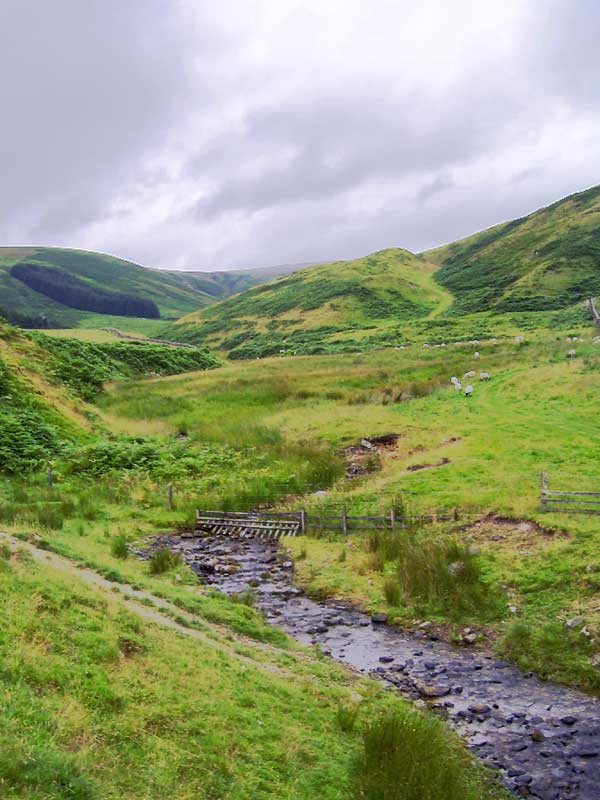
| Hopcarton from near
Mossfennoc |
Same location looking
north |
Near Kingledoors |
These places are in the Tweed
valley south of Drummelzier and still exist today. Hesilyard
and Haldeyhardsted have not been identified although
they must have been in the area. Hoprew is presumably
Happrew. The only place name in the area resembling
Merburn is Margate Burn but this identification is speculative.
The charter allows us to assume
a track suitable for waggons running on the west side
of the Tweed from present day Mossfennan to Kingledores
with a branch over to Hopecarton. Given the topography
the track must have been close to the present day road.
The route towards Melrose is
less clear. A reasonably direct route would have been
to cross the Tweed at the ford one mile SW of Drummelzier
and then followed much the same course as the present
day road through Stobo. This could lend itself to the
section of the charter that refers to the moor of Hoprew.
The most likely route for the King�s Highway would have
been down the valley of the Lyne.
West
Linton
Sleperisfield
In a charter dated between 1165 and 1190, Richard Cumin
gave the whole land of Sleperisfield to the Abbey of
Holy Rood. The boundaries of the land are stated as
"From the head of Kingseteburn as it descends into the
Line, and as the Line descends to Biggaresford, and
so by the high road to the next burn beside the Cross
and as that burn descends into Pollentarf��."
OPS, Vol.1, page
190
Liber Cartarum Sancte Crucis, appendix II, no. 5, page
210
Identification
 Although
Kingseteburn is not marked on any map the best fit would
be either the stream at NT 1352 or the one at NT 1253.
Both these streams run into the Lyne from the slopes
of King Seat. Although
Kingseteburn is not marked on any map the best fit would
be either the stream at NT 1352 or the one at NT 1253.
Both these streams run into the Lyne from the slopes
of King Seat.
Following the Lyne downstream,
the Roman road which in part was used in the Middle
Ages between Edinburgh and Biggar would be crossed near
Lynedale (Biggaresforde). The road then runs south-westwards
and crosses the West Burn near South Slipperfield. Chambers
in the History of Peeblesshire, p.463
notes that the West Burn used to be called the Polintarf.
Blith and
Ingolneston and the Halch
In the early 1200's a charter of William Cumyn, earl
of Buchane, gives the boundaries of a grant of land
in West Linton, viz. "as the Polntarfe falls into
the Lyne from the bounds of the canons of Holyrood as
the Lyne descends as far as the boundaries of the Newland
downward, and thence as the road goes from the Lyne
to the Tarfe, and along the Tarfe upwards to its source,
and from the source of the Tarfe as far as the Maydvane,
and from the Maydvane as far as Qwhitilaw, and from
Qwhitilaw to the source of the Garvalde, and from the
Garvalde southward as far as Mynidicht as the boundaries
of the canons descend beyond Mynedicht as far as the
source of the Alirburn, and from the Alirburn downward
as far as Blacfurde."
OPS, Vol. 1, Appendix, page
516
Mun.Vet.Com.
de Mortoun, Vol. 2, pps. 4,5
Identification
 The
placenames are relatively straightforward. Polntarfe
is the West Burn, the Maydvane is Medwin Water, Mynedicht
is Mendick and the Alirburn is Allary Burn, a small
stream just north of Medwin Cottage. Qwhitilaw is probably
Whitehill (see for example Thomson)
south-west of Ingratston, and Blacfurde is shown as
one kilometre south of Felton on the Tarf. The
placenames are relatively straightforward. Polntarfe
is the West Burn, the Maydvane is Medwin Water, Mynedicht
is Mendick and the Alirburn is Allary Burn, a small
stream just north of Medwin Cottage. Qwhitilaw is probably
Whitehill (see for example Thomson)
south-west of Ingratston, and Blacfurde is shown as
one kilometre south of Felton on the Tarf.
It can be seen from the map
that the Polntarfe (West Burn) joins the Lyne about
a mile south of West Linton. The boundary then follows
the Lyne downward towards Newlands where it then follows
the road between the Lyne and the Tarf.
 |
| Mendick Hill |
It is more than likely that
the road had the same line as the present A701 especially
as early maps show that the parish boundary (as defined
by this charter) ran along this road as far as Blyth
Bridge and then followed the Tarf upwards. Although
early maps have this as a road between Edinburgh and
Moffat and there is a reference in the Pont texts
and possibly the Lothians
map to what may be this road, it is not absolutely
certain that this was the case in the 1200's. However,
given the proximity to Newlands (owned by Newbattle
Abbey) and the reference to Holyrood, it is more than
likely that it would have been used to access Edinburgh
and Newbattle (near Dalkeith) through Leadburn at this
time. It may be identical to the road mentioned in the
Newlands charter below.
The Blackford over the Tarf
could indicate a route between the above road and the
Edinburgh to Biggar road, joining it near Dolphinton.
Lyntoun
Schelis
A charter dated to about the year 1370 contains
an interesting reference to the Cauldstane Slap, known
then as the "high road of the Carnes". It
reads, "As the Flahope descends into the water
of Lyne, and so ascending the water of Lyne as far as
the mouth of the Hollharschawburne; and so ascending
from the Hollharschawburne as far as the high road of
the Carnes; and so ascending along that road on the
north side to the Cauldstane on the east as far as the
Kippithill of Estir Carne; and so by the bra
on the south as far the the White Cragg as the water
descends to the upper Cragg of the Blak Loch - with
the common between Lynes heudes (the sources of the
Lyne); and so from the common between Lynes heudes as
far as the est heuyd of Dryhope-minich; and so from
Dryhop heuyd on the south along the boundary of the
water descending to Minitiullach; and so descending
as far as the Albecluch-heuyd; descending on the west
as far as the Westercluch-heuyd; and so from the Westircluch-heuyd
as far as the Stanelaw above the high road; and so from
the Stanelaw as far as the Flahope on the west."
OPS, Vol.1, Appendix, page
517
Mun.
Vet. Com. de Mortoun, Vol.2, page 87
Identification
 The
map shows those placenames which can be readily identified
from old maps. Some of the names towards the end of
the charter are difficult to identify although it is
likely that they marked the parish boundary to the north
and east of West Linton. The
map shows those placenames which can be readily identified
from old maps. Some of the names towards the end of
the charter are difficult to identify although it is
likely that they marked the parish boundary to the north
and east of West Linton.
Fortunately Hollharschawburne
can be identified as Hareshaw (at the north end of Baddinsgill
Reservoir) which makes it certain that the "high
road of the Carnes" is the road later known as
the Cauldstane Slap and extensively used by drovers.
The fact that it existed at such an early date is interesting
and raises the question of when it originated and what
its purpose was.
The "high road" mentioned
towards the end of the above extract can only be the
road between Edinburgh and Biggar. As it followed the
Roman road its course here is well known.
Newlands
 |
 |
| Cultivation terraces
at Newlands-click for larger image |
Old church at Newlands-
click for larger image |
A charter of Newbattle Abbey
states the boundaries as "From the Gallowhill as the
way passes by the Harestan to the burn of Cadcalenoch
and as that burn descends to the wood of Derelech��"
OPS, Vol 1, page
193
Reg. de Neub., charter
125, page 94
Identification
 It
is very difficult to identify these boundaries. There
is a Gallowberry Wood at NT 1243 and a Gallow Bank at
NT 141 464 but it is not certain if either of these
are the Gallowhill of the charter. There is a stone
circle at Harestanes (NT 124 442) which is one mile
SW of Blyth Bridge. As the boundaries are listed as
running from south to north this would favour Gallowberry
Wood but only if Harestanes is the place referred to
in the charter. Cadcalenoch and Derelech do not appear
on any early map although one wonders if there is a
link to Callends (NT 1545). The Head of Peblis, if interpreted
as the headwaters of Peebles Water would tie in with
Lecbernact mentioned later in the charter which is Leadburn
(Watson,Celtic Placenames of Scotland, p.142) but C
B Gunn (Hawick Archaeological Society 1930) refers to
a holy well of this name in Newlands (NMRS
record) which may have been sited near the old church
at Newlands (NT 161 466) which is some 10 miles from
Leadburn. It
is very difficult to identify these boundaries. There
is a Gallowberry Wood at NT 1243 and a Gallow Bank at
NT 141 464 but it is not certain if either of these
are the Gallowhill of the charter. There is a stone
circle at Harestanes (NT 124 442) which is one mile
SW of Blyth Bridge. As the boundaries are listed as
running from south to north this would favour Gallowberry
Wood but only if Harestanes is the place referred to
in the charter. Cadcalenoch and Derelech do not appear
on any early map although one wonders if there is a
link to Callends (NT 1545). The Head of Peblis, if interpreted
as the headwaters of Peebles Water would tie in with
Lecbernact mentioned later in the charter which is Leadburn
(Watson,Celtic Placenames of Scotland, p.142) but C
B Gunn (Hawick Archaeological Society 1930) refers to
a holy well of this name in Newlands (NMRS
record) which may have been sited near the old church
at Newlands (NT 161 466) which is some 10 miles from
Leadburn.
In view of these uncertainties
it is hard to say where this road was, although it is
highly likely that journeys between Newlands and Newbattle
Abbey would have been along much the same route as that
followed by the present day road.
Eddleston
Aldenhisslaeur
A charter dated between 1214 and 1233 refers to part
of the lands of Eduluiston formerly called Peniacob
which extended from "the head of Aldenhisslauer towards
the south by the Whitegate, to the Cross which stands
in the highway; and so across upwards to the top of
Erhacleth as the march stones show; thence descending
westwards to the Harecarneburn, and along the Harecarneburne
downwards to the water of Peblis; thence by that water
upwards to the slack (gulam) of Aldenhisslauer; and
the whole of Harecarflat, with one acre of the ground
which is between it and the highway; and with the meadow
lying next to it as far as Kingisforde�.."
OPS, Vol.1, page
213
Regist.
Glasg. page 142
Identification
 Watson
succeeds in identifying Aldenhisslauer (Celtic
Placenames of Scotland, p.135) as one of the headwaters
of the Eddleston (sometimes called Peebles) Water which
runs past Cowie�s Linn (NT 2351). Erhacleth is probably
Early Burn shown on the old 6"map (Peeblesshire
sheet VI) and now known as Shiplaw Burn. Harcareflat
must have been in the vicinity of present day Harcus
shown on Blaeu as Harcas, with Harecarneburne one of
the streams flowing into Eddleston Water nearby. Watson
succeeds in identifying Aldenhisslauer (Celtic
Placenames of Scotland, p.135) as one of the headwaters
of the Eddleston (sometimes called Peebles) Water which
runs past Cowie�s Linn (NT 2351). Erhacleth is probably
Early Burn shown on the old 6"map (Peeblesshire
sheet VI) and now known as Shiplaw Burn. Harcareflat
must have been in the vicinity of present day Harcus
shown on Blaeu as Harcas, with Harecarneburne one of
the streams flowing into Eddleston Water nearby.
One interpretation would be
that by following the Aldenhisslauer one would reach
the Whitegate and then Early Burn, i.e. in the main
valley. This however would conflict with the later part
of the description which implies the boundary ran north
up the main valley along the same course, i.e. overlapped.
This can be avoided by going upstream from Cowie�s Linn
to a road that early maps show ran from Whiterig down
to Lyne and ultimately Stobo and Drummelzier and the
upper Tweed valley. From this road one would reach the
Early Burn and the Harecareburn and then the Eddleston
Water.
 |
 |
| Looking
north towards Earlyburn |
The "Whitegate" |
The reference to the ground
beside the highway would have applied to the west side
of the river as the early road ran there and not to
the present day road which is a later turnpike - the
course of the early road is still shown on modern maps.
Kingisforde does not appear on early maps but was probably
near Earlyvale and Waterhead (NT 2450).
If this interpretation is correct
it means that two roads are being referred to. The one
in the main valley suggests a route between Edinburgh
and Peebles. The Whitegate is more difficult - the road
shown on early maps indicates its course in this locality
but does not allow us to assume it ran north of Whiterig,
or down to Drummelzier in mediaeval times.
Widhopeburne
 In
a charter dating from between 1196 and 1214, Ellen of
Morville gave Melrose some land in Killebeccokestun
(Eddleston). The charter says "from the head of Widhope
towards the east, by the middle of the hill-top, to
the Old Castlestead; thence across to Careligburne;
thence by the march between the plough-land and the
moor to Haropburne; and so down that burn to the place
where Haropeburne and Carelgiburne meet; and so upwards
by Careligburne to the ditches dug for a march, and
so westwards by the ditches dug for a march, to the
ford of Widhopeburne towards the Line; and so upwards
by that burn to the head of Widhope aforesaid." She
also gave the monks a right to use the common pasture
in the township with free entry and egress through her
lands and those of her men. In
a charter dating from between 1196 and 1214, Ellen of
Morville gave Melrose some land in Killebeccokestun
(Eddleston). The charter says "from the head of Widhope
towards the east, by the middle of the hill-top, to
the Old Castlestead; thence across to Careligburne;
thence by the march between the plough-land and the
moor to Haropburne; and so down that burn to the place
where Haropeburne and Carelgiburne meet; and so upwards
by Careligburne to the ditches dug for a march, and
so westwards by the ditches dug for a march, to the
ford of Widhopeburne towards the Line; and so upwards
by that burn to the head of Widhope aforesaid." She
also gave the monks a right to use the common pasture
in the township with free entry and egress through her
lands and those of her men.
OPS, Vol. 1, page
214
Lib. De Melros pages 71,
72
Identification
This is very difficult to interpret as names seem
to have changed and some of the burns are not named
on the early maps. The map shows a possible interpretation
but it is hard to say if the Widhopeburne of the charter
is the Lyne Burn of the early 6" map (Peeblesshire,
sheet VIII) or a stream a little further west. The ford
would have been on one or other of these streams and
may just have given access to Lyne Common a little to
the south although this is not certain.
Top
Back to Mediaeval Roads:
Evidence from Monastic Charters
|