|
Overview
Dere Street was one of the two main routes taken by
the Romans into Scotland. Initially it ran from York
to Camelon near present day Falkirk where there was
a staging area used prior to the campaigns in the north.
Later it may have had a branch to the eastern end of
the Antonine Wall - this had a road, the Military Way,
running along its length.
It is Flavian in date (AD 77-86/90), but was re-used
in the Antonine re-occupation of the 2nd.century (AD
139-165) and also during the Severan campaign (AD 208-211).
At a later date it was used by the Northumbrians as
indicated by its name (Deira was the name of the area
around York) and in places may have deviated from the
Roman line.
The use of the name here is just for convenience and
refers to the Roman road as far as Camelon, and Northumbrian
Dere Street as far as Dalkeith. The latter may have
had a different line to the Roman road in one or two
places: it is not clear how the Northumbrians referred
to it north of the Dalkeith area which is where the
last known reference to "Dere Street" occurs.
Its course from the border to Newstead is well established
though one or two researchers have suggested that in
parts it incorporated existing native tracks - see for
example Harry Inglis,
The Roads that led to Edinburgh, PSAS, Vol. 50 (1915-16),
p.32 ff. Beyond Newstead, its course through Lauderdale
has not been established beyond doubt, one theory favouring
a route just west of the Leader running close to some
camps and another favouring a route on higher ground
a couple of kilometres further west. This latter route
is mentioned in several charters as Malcolm's Road and
may have been made or improved by either Malcolm II
(r. 1005-1034) or Malcolm III (Malcolm Canmore, r.1058-1093)
to consolidate the territory gained from Northumbria
after the Battle of Carham in 1018. Alternatively it
could have been used by Malcolm IV (r.1153 - 1165) to
reach Jedburgh, a favourite place of residence. Whether
it was the Roman Dere Street or a new course taken by
the Northumbrians (leaving the old Dere Street in the
valley below) or an unrelated road made or improved
by one of the Malcolms is difficult to say.
North of Lauder its course is more certain as charters
refer to Dere Street, taking us past Oxton and Channelkirk
to Soutra. Its course has been identified on the ground
between these last two places. North of Soutra, both
charters and archaeological evidence point to it making
to Elginhaugh, a fort near Dalkeith. From this point
onwards there are few clues as to its course other than
a sighting at Liberton, marching camps at Gogar, a milestone
at Ingliston and one or two possible antiquarian references
although it undoubtedly made for Camelon from where
a road leading northwards has been traced. In the Antonine
period there were stations at Inveresk and Cramond that
must have been linked to the Antonine Wall, probably
at the fort at Carriden but practically the only clues
we have to these are antiquarian references. A couple
of these are quite intriguing but others are vague and
do not inspire confidence.
From Hadrian's Wall to
Newstead
 |
| The course from the border to
Trimontium. Based on quarter-inch OS map, 1922.
With thanks. |
The road came from York to Corbridge (15 miles west
of Newcastle) from where Dere Street continued north
through Redesdale on the line of the A68 to the fort
at High Rochester called Bremenium - there are several
forts and marching camps on this stretch. Another road
ran NE from Corbridge to Berwick via a fort at Learchild,
near Alnwick, which was joined by a road from Bremenium.
From High Rochester, Dere Street runs into the Cheviots,
reaching the present border at Chew Green where there
is a fortlet of Antonine age and marching camps which
probably date from both the Flavian (AD 77-86/90) and
Antonine periods (AD 139-165). On this stretch Dere
Street is called Gammel's Path. There is a small fortlet
at Brownhart Law (NT 790096) just north of Chew Green
which was used for observation and signalling.
A few miles further on is the native fort of Woden Law
which guarded an important route over the Cheviots.
Once Woden Law was overcome the Romans incorporated
the route into Dere Street. It is not certain if nearby
earthworks were native defences or practice siege works
- the Pennymuir camps could have served as training
bases.
 |
| Looking from Pennymuir
over to Towford and Woden Law. Dere Street ascends
the col to the left of Woden Law. Click for larger
image. |
Dere Street crosses a small stream at Towford and runs
past the Pennymuir camps and Whitton Edge to a small
fort at Cappuck that presumably guarded a crossing of
the Oxnam Water. From here it is remarkably straight,
crossing the Teviot (and possibly the Jed) near Monteviot,
and running directly towards the Eildon Hills where
there was a major fort at Newstead, occupied in the
Flavian and Antonine periods and perhaps later.
Between the border and Newstead many parts of the road
are well preserved and its line is more or less evident
all along its course.
Charter Evidence
Both Curle (A
Roman Frontier Post and Its People: The Fort of Newstead
in the Parish of Melrose, James Curle - see section
on the Roman Road on pages 7-15) and Hardie (The Roads
of Medieval Lauderdale, R.P.Hardie, Oliver & Boyd, Edinburgh,
1942) give good coverage of charter references to Dere
Street on this stretch of the road. From south to north
these references are:
1. a reference to Deorestrete (south of the border)
in the History of St Cuthbert (c.1104-1108) which was
written by Simeon of Durham.
2. Melrose charters (Vol.1; p.122, no.131 and Vol.1,
p.247, no.280 - see References
below for links to relevant monastic cartularies) for
Hounam and Rashaw refer to Dere Strete as it runs north
from the vicinity of Woden Law by the lands of Hounam
and Rashaw. The charters are somewhat difficult to interpret
but this does not matter as the course of the road is
well known in this area. It forms the boundary between
Hounam and Oxnam parishes for several miles.
3. A Melrose charter for lands in Maxton parish (Vol.1,
p.77, no.90) near to Lilliardsedge which were bounded
by Dere Street.
4. Another Melrose charter (Vol.1, p.219, no.244) refers
to Dere Street in much the same area. Interestingly
it talks of Dere Street intersecting a road that ran
from Roxburgh to Annandale. This is thought to have
been based on the old Craik Cross Roman road.
5. On the boundary of Lessudden (St Boswells), there
is a mention in a Melrose charter (Vol.1, p.76, no.88)
of Dere Street descending obliquely to a burn. There
is also a Dryburgh charter (p.44, no.58) that gave land
to the abbey "west of the church of St Mary of
Lessedewyn as far as the great road that led towards
Eildon" (The History and Antiquities of Roxburghshire
and Adjacent Districts, Alexander Jeffrey, vol.
iv, p. 173).
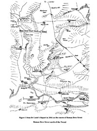 |
 |
|
Maps to go with Dr Lonie's
paper. Click for larger images. With thanks to
Trimontium
Trust.
|
Although the charters are vague as to the position
of Dere Street in this area, it is at this point that
William Lonie gives a detailed account of the road between
St Boswells Burn and the Clackmae Burn, a distance of
6 miles (Roman
Dere Street over the River Tweed from St Boswells Burn
to the Clackmae Burn, William Lonie, The Scottish
Naturalist, Vol.116, pps 3-28, 2004 - copy on Internet
Archive). At this particular point he has the road cross
St Boswell's Burn with traces up to Newtown St Boswells
and Eildon village. From there it ran to a bridge at
Leaderfoot, very close to the old (1798) road bridge
there. This bridge is mentioned in Milne's Description
of the Parish of Melrose (1743) as still being visible
and from which worked stones were being removed when
the water was low.
From Newstead to Lauder
 |
| Courses are approximate,
particularly Roy's Girthgate route - see OS for
known stretches. The eastern branch of the road
running from the Tweed opposite Newstead is the
"Hie Street" of Hardie and Lonie's Roman
Dere Street. The western branch is Lonie's continuation
of Malcolmesrode/Northumbrian Dere Street. Based
on quarter-inch OS map, 1922. With thanks. |
There is an immediate problem with the course north
of the Tweed where three courses have been proposed
by different authorities.
1. Girthgate
Roy's line, which is that of the Girthgate, would not
be accepted today - see Military
Antiquities of the Romans in North Britain, p.103.
2. Malcolmesrode
Using charter evidence Hardie thinks that the Roman
road (Dere Street) had the line of Malcolm's Road from
a crossing of the Tweed near Newstead up to the well-defined
track that runs on the high ground about 2.5 km west
of the Leader and which is used in part as the Southern
Upland Way.
Lonie also has the Roman road take much of this line
with the exception that he has Malcolm's Road diverge
from the Roman road at Housebyres Moss to run south
to the Tweed near Gattonside. He suggests that this
latter line is that of Northumbrian Dere Street. North
of the junction near Housebyres Moss he would see Northumbrian
and Roman Dere Street as having the same line but with
later improvements which he explains in detail.
While its central section is easily identified, its
northern section as it runs down to Lauder is not so
certain.
3. Leader Valley
The RCAHMS following Chalmers have it run close to the
Leader, passing several Roman camps on the way and suggest
that the other track was mediaeval (see for example
NT53NE
72). Margary in his Roman Roads of Britain also
thought that Malcolmesrode was mediaeval though possibly
on an earlier Roman road, having noted some quarry pits.
Whatever the case, it has the characteristics of
a ridgeway which is suggestive of a very early development.
The Malcolmesrode and Leader Valley lines are dealt
with separately below.
Malcolmesrode
 On
the north side of the Tweed, Lonie found indications
that the Roman road (Roman Dere Street) crossed
the Tweed at a likely bridge at Leaderfoot and ran in
a north-westerly direction to Malcolm's Road (used as
part of the Southern Uplands Way), joining it a few
hundred metres north of Housebyres Moss. South of this
junction, he considers Malcolm's Road to have the line
of the Southern Upland Way to reach the Tweed west of
Gattonside and that this might be equivalent here to
Northumbrian Dere Street, i.e. that a diversion from
the Roman road had developed here. His remarks on the
roads north of the Tweed are interesting, including
what he calls the enclosed road to Lauder, which had
the line of Malcolm's Road in its central section and
which he sees as having been improved at a much later
date, possibly to give access to the railway at Lauder. On
the north side of the Tweed, Lonie found indications
that the Roman road (Roman Dere Street) crossed
the Tweed at a likely bridge at Leaderfoot and ran in
a north-westerly direction to Malcolm's Road (used as
part of the Southern Uplands Way), joining it a few
hundred metres north of Housebyres Moss. South of this
junction, he considers Malcolm's Road to have the line
of the Southern Upland Way to reach the Tweed west of
Gattonside and that this might be equivalent here to
Northumbrian Dere Street, i.e. that a diversion from
the Roman road had developed here. His remarks on the
roads north of the Tweed are interesting, including
what he calls the enclosed road to Lauder, which had
the line of Malcolm's Road in its central section and
which he sees as having been improved at a much later
date, possibly to give access to the railway at Lauder.
Charter Evidence for Malcolmesrode
The charters are as follows (further details can
be found in Hardie and a summary account here):
1. Hardie refers to a charter of 1590 that mentions
a "hie streit" just north of the Tweed which
can hardly be anything but Roman Dere Street, although
unlike Lonie he thinks it likely to be a continuation
of Malcolm's Road. The charter is from Selections
from the Records of the Regality of Melrose, Vol.3,
1917, page 386 (Scottish History Society) with the
relevant section reading: "...and fra thence (Lurdane
Hole, a ford on Packman's Burn) ascendand south merchand
with the landis of Drygrange on the eist as the hie
streit gais to the Drycleughhead and fra thence descendand
the said cleugh to ane pairt callit the Hauch yet and
fra thence descendand to the auld dyk steid standis
to the foresaid fuird in Tweid callit the Turf Fuird."
Hardie identifies the Turf Ford as the one directly
north of Newstead.
This charter is important as other than Lonie's work
and the Sorulesfield charter it is the only evidence
we have for the route taken between the Tweed and the
central section now followed by the Southern Upland
Way.
Although the location of the "hie streit"
is quite vague, it is clear enough that it lay between
Gattonside and Drygrange on the east and can presumably
be linked to Lonie's findings.
2. Sorulesfield (Melrose, Vol.1, p.87, no.101).
This also is important as it places Malcolmesrode near
to Sorrowlessfield which lies above Drygrange . It is
referred to as "....the road going towards Louueder
along the causeway which is called Malcholmisrode....".
3. Kedsley (Dryburgh, p.80, no.113). This was an agreement
between Dryburgh and Melrose on the boundary between
Colmslie (Melrose) and Kedslie (Dryburgh). One of the
boundaries was "the road that leads to Lauder"
which from the context must be Malcolmesrode.
4. Elwinseley and Herdesley (Dryburgh, p.83, no.116).
This charter relates to an outlier of Earlston parish
on the west side of the Leader, where the westernmost
boundary is given by Malcolmesrode. The old parish boundary
used to run along the track now used as the Southern
Upland Way, just to the west of Kedslie Hill.
5. Blainslie (Melrose, Vol.1, p.83, no.95). This charter
of Richard de Morville allowed Melrose to cultivate
land in Blainsley from "Windeslaue, and from there by
the great road which descends from Windeslaue towards
Lauder, as far as the marches of Lauder." (Monastic
Annals of Teviotdale, J.Morton, p.263). Hardie uses
a charter of 1547 to identify Windeslaue as the summit
200 metres west of Jeaniefield. The Milkeside charter
below indicates that the "great road" ran
as far as a road branching to Milkeside which was probably
on the Southern Upland Way track a few hundred metres
north of Fordswell. Beyond this point the course of
the "great road" is not absolutely certain:
early maps such as Armstrong and Blackadder show a line
very close to the Southern Upland Way, although passing
closer to Cold Shields; whereas Roy goes by Woodheads.
6. Milkeside (Melrose, Vol.1,
p.96, no.108) As for the charter above this refers
again to the "great causeway which descends from
Windeslaue to Lauwder" and which then runs northwards
to the road to Milckeside. As noted the line must be
that of, or close to, that now taken by the Southern
Upland Way.
Leader Valley
Chalmers and RCAHMS
Chalmers depended on the observations of his correspondent
Kinghorn who surveyed the remains of Dere Street in
1803 (Chalmers, Caledonia, v.1,
p.140ff; vol.3,p.90ff).
While old antiquarian reports can sometimes be confusing,
Kinghorn's account must be given credence if he says
the remains of the road were quite distinct. The course
he gives to Dere Street, although very close to the
minor road running up from Drygrange through Kedslie
and Blainslie, is not the same as this road. The minor
road was in fact the turnpike built after the Turnpike
Act of 1768 (see Border Highways, John James Mackay,
1998, chapter 9) and is shown on Armstrong (1775) and
Taylor & Skinner (1775) but not on the Military
Survey of c.1750.
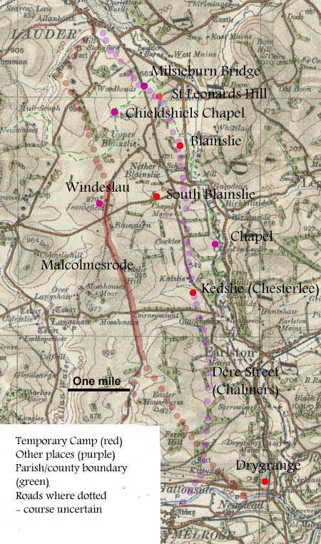 |
| Course of Malcolmesrode,
and of Dere Street after Chalmers. The easterly
branch of the road running from the Tweed opposite
Newstead is the "Hie Street" of Hardie
and Lonie's Roman Dere Street. The westerly branch
is Lonie's continuation of Malcolmesrode/Northumbrian
Dere Street. Based on half-inch OS map, sheet 28,
1914. With thanks. |
Chalmers, referring to Kinghorn, routes Dere Street
from a ford opposite Melrose up the west of the Leader,
close to the turnpike as far as a camp called Chesterlee
(Kedslie-NT54SE 20) - the road in this area could easily
be seen. It crossed the turnpike and a small stream
that joined the Leader below Chapel which would place
this about 400 metres above today's Kedslie.
It then ran up to a Roman site called Wass or
Walls at New Blainslie (site NT54SE 18 is 200 metres
from New Blainslie). Kinghorn says that the road was
very evident for a mile and a half north of here when
it crossed the turnpike again, and a nearby stream,
half a mile ENE from Chieldshiels chapel. It then ran
towards Lauder (The Rev. A Milne in his History of Melrose
takes the road up through Chieldshiels chapel).
Details of the Roman camps (all temporary camps)
can be found on the Canmore
database (Drygrange-NT53NE 33; Kedslie-NT54SE 20;
Blainslie-NT54SE 18; South Blainslie-NT54SW10; St Leonards
Hill-NT54NW 14) - Canmore entries for Dere Street on
this stretch refer mostly to Chalmers. It is interesting
to see that the camps are all on or close to the presumed
line of the road.While this is suggestive evidence it
is not absolutely conclusive. By their nature, temporary
camps indicate the passage of a military unit rather
than a settled base served by roads, although of course
they could use an already existing road. The St Leonards
camp (currently the largest known camp in the Roman
empire) has been dated to the Severan campaign between
208 and 211.
Charter Evidence
One interesting point is that charters of Richard de
Morville and his son William refer to a road from Lauder
that led towards Birkenside (Melrose, p.96, no.108,
also no.109). In these it is called a magnum stratum
which implies it was paved. It formed a parish/county
boundary for about one kilometre which still exists
and can be clearly seen on aerial photographs.
The feature runs through the St Leonards Hill camp (as
shown on the plan in Roman Camps in Scotland, Rebecca
H Jones) and touches on the north side of the Blainslie
camp and possibly continues through it though it does
not appear as a cropmark. As the Waas site of Kinghorn
was at Blainslie it is very likely that this is the
feature that he said was very evident north of here.
If it is a road, the question is whether it is Dere
Street as Kinghorn suggests, or if it is a road to Birkinside
and perhaps Roxburgh as Hardie suggests, though whether
Roman or mediaeval is uncertain. As it stands the evidence
is insufficient to determine which of these possibilities
is correct.
Conclusion
Both the Malcolmesrode and the Leader valley
routes have their merits but there is a degree of uncertainty
that makes it difficult to decide between them though
the presence of camps on the Leader valley line is quite
compelling. Fortunately, a clearer picture is possible
for the next section of the road, north of Lauder, which
we deal with below.
From Lauder to Soutra
 |
| Roy's Girthgate route is approximate
- see OS for known stretches. Based on quarter-inch
OS map, 1922. With thanks. |
The course immediately north from Lauder is not known
exactly but there is a charter for land at a place called
Newtoun (probably Lauder) between Derestrete and Thirlstan.
Whether this meant the road ran through present day
Lauder or to its west is not clear. A couple of miles
to the north it is picked up (on charter evidence) at
Midburn and probably ran up to Midburn close to the
line of the old railway and the western edge of the
Roman camp at Blackchesters (see Rebecca H Jones, Roman
Camps in Scotland).
A charter for Samsonshiels allows it to be identified
as having the course of a minor road from Midburn to
Burnton and Oxton. At Oxton, another charter indicates
it ran through the village. From there it ran directly
to Channelkirk House and the camp one kilometre to the
north-west - Canmore record NT45SE
52.00. From there its course is marked on recent
OS maps as far as Soutra Aisle - see Canmore record
NT45NE
21 which continues it closer to Soutra Farm.
Charter Evidence
Newtoun
A Dryburgh charter (p.145, no.201) refers to land
at Newtoun that extended from the west side of Derestrete
to the Marches of Thirlestan (....ab occidentali parte
de Derestrete in longum et latum juxta metas et divisas
de Thirlestan). Although others had placed it at Newton
Don and Newtown St Boswells, Hardie is surely correct
in placing it at Lauder which is close to Thirlestane.
Samsonschieles
This is a confirmation to Dryburgh (p.123, no.176) by
Pope Celestine III in 1196 of lands in Samsonshiels
(now Shielfield), "namely, a toft of one rood in
front of, and a croft with land contiguous to, the same
croft of three full acres, close to my house from the
west, and also that land, arable as well as meadow,
which lies on the west side between the aforesaid croft
at the top, and the boundary of the burn which is between
my land and Pilmuir, that is to say, beginning on the
south side at a certain stone cross set up on the edge
of the same stream, and extending as far as Derestrete
in length northward. To this, likewise, an acre which
belonged to William, Robert's son, with the land which
lies between the same acre and ditch between Samsonshiels
and Pilmuir in breadth, and from the aforesaid stone
cross as far as the way which leads to Wenneshead in
length, and so by the same road on the east side continually
to the ditch at Pilmuir as far as Bradestrutherburn,
and thence going on towards the north exactly as that
stream formerly ran to the Leader." (transl. Allan,
History
of Channelkirk, Edinburgh, 1900, p.59)
Using the clue afforded by the diversion of the stream
(formerly Bradestrutherburn, now the Mid Burn) just
below the farm of Midburn, as well as the parish boundary
following the old course of the stream, Hardie (page
87) is able to identify Dere Street as the minor road
leading to Burnton and Oxton. Wenneshead is now Wanside
on the north side of the Lammermuirs and is reached
by a track running north from Carfraemill.
Canmore record NT55SW
40.
Oxton
 |
| The line of Dere
Street through Oxton parish. Based on half-inch
OS map, sheet 28, 1914. With thanks. |
The Oxton charter dating from 1206 was for lands gifted
to Kelso (Kelso p.202, no.245). These lay "From
the head of Holdene descending by the Holdene burn to
Derestrete and then by Derestrete heading north to Fuleford
and, by Samson's divisions, to the Leader, and so by
the Leader ascending in a straight path to the east
end of the said town of Hulfkeliston, and from the east
end of Ulfkiliston taking a straight path by the south
street and ascending to Derestrete...."
Both Hardie (Roads of Mediaeval Lauderdale - p.88) and
Allan (History
of Channelkirk, p.664) identify the Holdene burn
as the Howden Burn near Overhowden (NT49 52) along which
the boundary ran to reach Dere Street and then turn
north. Dere Street here has the line of the minor road
running from Midburn into Oxton, which ties in well
to the last charter.
Fuleford may have been over one of the burns just north
of here (see Armstrong
map) or nearer to Carfraemill. In any case it followed
the Leader up to Oxton where the old
6"map (Berwickshire, sheet XIII) clearly shows
a road running from Nether Howden west into Oxton.
Hartside (Hertesheued)
This charter is mentioned by both Allan (History
of Channelkirk, p.441) and Hardie, p.89 and is for
lands at Hartside which mentions a road from Wedale
to Derestre(te). There is not enough information to
place Derestrete exactly although Hartside is only a
kilometre from the camp at Channelkirk.
Soutra
There is a charter of the hospital of Soutra (Registrum
de Soltre p.24, no.28) that refers to a via regia
leading towards Roxburgh, viz. "...and as far as
the rivulet to the east in Lynnesden, and from that
rivulet eastwards by the road which leads to the royal
road leading towards Roxburgh."
".....et usque ad rivulum orientalem in Lynnesden
et ab ipso rivulo orientali per viam que ducit ad regiam
viam tendentem versus Roxburgh."
As Linn's Dean lies about one mile east of Soutra Aisle
neither of the roads referred to in this locality can
be Dere Street although the via regia may have been
identical with Dere Street for some part of its length
north or south of here. Hardie links the via regia to
the Birkenside road south of Lauder.
From Soutra to Dalkeith
 |
| Course of road north of Soutra,
and the lands of Gocelyn the Cook as determined
by Hardie. Parish boundaries
in green. Based on quarter-inch OS map, sheet 2,
1936. With thanks. |
Archaeological and charter evidence indicate that the
road ran much along the line of the A68 as far as Pathhead
and then along the minor road to the outskirts of Dalkeith
at Whitehill. From there it would have run to the fort
at Elginhaugh.
It is thought that it ran from Soutra Aisle to the south-west
of Soutra Farm then a couple of hundred metres south
of the A68 to the west of Fala then crossing to the
north side of the A68 to run towards Bleak Law. From
there the line may be shown by a long stretch of parish
boundary running to the outskirts of Pathhead from where
it would take the line suggested by Hardie, viz. the
minor road passing through Chesterhill.
Charter Evidence
Gocelynton
A Newbattle charter (p.7,no.10) records a gift by
Malcolm IV of the lands of Gocelyn the cook that lay
between Newbattle to the west, Cousland to the north,
and Cranston to the south. Derestrete is mentioned as
one of the boundaries.
In his analysis, Hardie convincingly argues that the
territory was that part of Newbattle parish that extends
eastwards into Cranston parish. This would indicate
that Derestrete was the minor road running from Pathhead
into Dalkeith. He notes another charter (p.229, no.269)
that mentions Derestrete in connection with Cowden Bog
which is one of the boundaries of Gocelynton and another
charter (p.9, no.12) that may contain a reference to
Derestrete.
From Dalkeith westward
Overview
There is quite a contrast between this stretch of
Dere Street and the previous stretch. There are no charters,
no obvious lengths of road; just one or two pieces of
archaeological evidence and antiquarian tradition. Sometimes
these traditions are intriguing and have the air of
truth, other times they seem speculative or so vague
as to be useless. Clearly there are dangers in taking
some of these literally but other than the all important
archaeological evidence (which includes a sighting at
Nether Liberton, marching camps at Gogar, and a milestone
at Ingliston) there is little else to go on. In any
case, these traditions do have their own historical
interest.
Another difficulty arises when we assume the forts at
Inveresk and Cramond are from the Antonine period and
from this infer a road system at that time. The reason
is that some evidence has been interpreted to suggest
that the sites may have been occupied in the earlier
Flavian period which could mean that some routes thought
to be Antonine may have existed in Flavian times - see
for example Canmore record NT17NE
137 and DES
1995 (a), page 53 (doi:10.5284/1000284) for Cramond.
It is generally thought that Dere Street was
built under Agricola early in his invasion. It is likely
to have headed from Elginhaugh directly to Camelon which
was the jumping off point for the invasion of the north
and beyond which a road led for a considerable distance
into Perthshire and beyond. Two routes are feasible:
one directly to Camelon, perhaps passing the fort of
Mumrills, and going through what is now Linlithgow;
the other passing along a ridge about a mile north of
Linlithgow and again heading to Camelon - there are
antiquarian references for this road.
In the Antonine period the situation is more complicated.
The main purpose of the advances at this time seems
more to do with the re-occupation of territory that
had already been conquered and the establishing of a
frontier line rather than aggressive campaigning in
the north - only three forts in Perthshire date from
this time. Camelon with its road to the north would
be used to reach these but much of the movement on the
east side of Scotland must have been to reach Inveresk
and Cramond and ultimately the Antonine Wall with its
accompanying Military Way which once built could then
be patrolled.
The antiquarian literature postulates that there was
a link between Inveresk and Cramond by roads running
through Leith and through central Edinburgh. Inveresk
may have been connected to Dere Street by a road said
to have been visible in the 1700's and making to Lugton
or nearby Elginhaugh, or perhaps more directly by a
branch from the south, perhaps from near Pathhead. In
addition, Maxwell refers to parallel cropmarks seen
on aerial photographs on the right bank of the Esk near
Dalkeith that could be a branch from Dere Street (Two
inscribed Roman stones and architectural fragments from
Scotland, G S Maxwell, PSAS, 113 (1983), 382 (doi:10.5284/1000184).
It is unclear if the section of Dere Street that ran
from Elginhaugh to the west of Edinburgh was used. A
milestone at Ingliston suggests it was but this could
also fit a road coming from Inveresk through central
Edinburgh (intersecting the earlier course of Dere Street)
or even from Cramond.
A further complication is the road up the east side
of the Pentlands and how this relates to the remains
of a road said to have been evident north from Lothianburn
and which was thought to point towards Cramond. The
existence of this road may at least be proved some day
as Sir John Clark of Penicuik had the modern turnpike
laid over it for a mile of its length - see here.
From Ingliston and Cramond westwards the course is
somewhat uncertain. Dere Street itself may have had,
as we saw, two possible routes in Flavian times and
the road must have continued in use as shown by the
milestone dated to AD 140. While it may have kept its
original course to Camelon, it could also have been
redirected or had a branch to Blackness or Carriden
fort where the Antonine Wall and the Military Way would
have been reached.
So far as Cramond is concerned there is a long-standing
antiquarian tradition that it was connected to the fort
at Carriden from where the Military Way that ran along
the length of the Wall would be accessed. The route
given is Barnbougle, Ecklin and Abercorn to Blackness
and Carriden with a possible link from Blackness to
the road running past Walltown and over Airngath Hill.
The marching camps used in the Severan campaigns from
AD 208-211 show that Dere Street was followed at least
as far as Pathhead. Ultimately the invasion force made
for Dunipace, near Camelon, prior to its advance to
the north.
Flavian period (AD 77-86/90)
 |
| Possible course of Dere Street
in Flavian times. Based on quarter-inch OS map,
sheet 3, 1923. With thanks. |
The Canmore entries (NT26NE
76 and NT27SE 444) have the road follow the line
of the A7 (this has been re-numbered as the A772 though
the Canmore entries retain the old A7 number) as far
as Nether Liberton, less than two miles from the city
centre although recent work (NT26NE
70) has found possible remains of a Roman road a
kilometre or two east of this line at Edmonstone. The
Edmonstone find may link to a remark of Harry Inglis
(The
Roads that Led to Edinburgh, PSAS, Vol. 50 (1915-16),
p.36-38) that there may have been a road continuing
onwards from Whitehill along the parish boundary towards
Newton, Woolmet and Craigmillar Castle and that it might
be the "road of the Standing Stone" mentioned
in a charter of Dunfermline Abbey (p.265, charter 384).
Margary (section 8g) had thought there might be traces
of an agger near Whitehill at the point where the parish
boundary carries straight on.
The course through Edinburgh is now lost but the milestone
near Ingliston (Canmore entry - NT17SW
22) and marching camps at nearby Gogar Green are
likely to mark its continuation. The milestone is dated
to AD140 but this is thought to indicate that the road
was re-used at this time rather than the road being
made at this date. It mentions Trimontium, i.e Newstead.
The former Gogar Loch (where the South Gyle Centre is)
would have had to be avoided and it is of note that
the boundary between Ratho and Kirkliston parishes runs
along the main road here for just over a mile.
On two of his campaigns (1298 and 1303) Edward I stayed
at Kirkliston on his way to Linlithgow and probably
passed through also when travelling between Edinburgh
and Linlithgow. This is a strong indication that a route
existed as far as Linlithgow at that time although strictly
speaking we cannot assume that it originated in Roman
times.
West of Kirkliston there are two
feasible routes (given the ultimate destination of Camelon).
One would very directly run through what is now the
town of Linlithgow to Polmont and the fort of Mumrills,
from where it is less than 4 miles to Camelon. This
option would require the Avon to be crossed near Linlithgow
Bridge. The other would run along a ridge about one
mile north of Linlithgow Loch.
 |
| Alternative courses of Dere
Street near Linlithgow and possible later roads.
Based on half-inch OS map, sheet 27, 1913. With
thanks. |
There are a couple of antiquarian references for this
second route. George Waldie in A
History of the Town and Palace of Linlithgow,1879,
says a Roman road ran along the summit that lay between
Linlithgow and the eastern end of the Wall (which he
places at Carriden) and passed the farm of Walton (page
19). This suggests he was talking about the east-west
ridge of which Airngath Hill is a part. He also says
that remains of a causeway coming from Blackness were
removed 50 years before on the ridge above Walton (page
20). From his descriptions it is not quite clear if
these were one and the same road, namely a road coming
from Blackness and then crossing over Airngath Hill;
or a spur coming from Blackness to join a different
road (Dere Street) crossing Airngath Hill. Certainly
it has long been thought that there might have been
an outpost at Blackness. A reference in Discovery and
Excavation in Scotland (1998,
p.38, C McGill) identifies a road near to the Allanvale
Hotel (NT0150 7907) which could be the Airngath road
or even the Blackness road.
Another reference is from Borrowstounness
and District, Thomas James Salmon , 1913 who says
on page 10 "that the road which comes east from
Upper Kinneil and Rousland and over the Erngath Hills
by the golf course and Bonsyde was one of the old Roman
roads though not the Military Way. It may not have run
direct from Bonsyde to the Walton but traces of it have
been found about the Boroughmuir and also at Grougfoot,
near the Walton."
There are also vague references from Robert Sibbald,
William Maitland and one or two others which we will
deal with below under the Antonine period.
While not proof, it is interesting to note the occurence
on this putative line of a Cauldcotts one km west of
the House of the Binns which Codrington in his Roman
Roads of Britain says is nearly always associated with
Roman roads. Also of note are some lengths of parish
boundary on, or near this line - these are shown on
the map.
From Dalkeith westward - Antonine period (AD 139
- 165)
Inveresk and Cramond
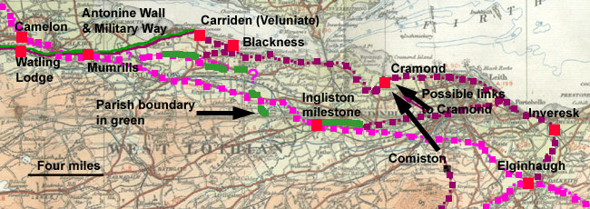 |
| Possible roads in the Antonine
period. The earlier course of Dere Street is shown
in light purple. Based on quarter-inch OS map, sheet
3, 1923. With thanks. Click for larger image. |
In the Antonine period, Inveresk and Cramond were established
which raises a couple of questions about the road system
at that time. There were antiquarian reports that a
causeway was evident between Inveresk and a camp at
Lugton (Sibbald, noted in Chalmers Caledonia, v.1,
p.143) or Sherrifhall (OSA
- Inveresk - go to "Browse scanned pages).
A camp has never been identified at Sherrifhall - see
the Armstrong map (NLS)
where it would have lain just north and east of the
modern roundabout but there is one at nearby Lugton
as well as the fort at Elginhaugh, so this could be
a valid reference for a link from Inveresk to one or
other of these stations or even Dere Street here. No
course for the link road is given although a fairly
straight line could be assumed. We have also noted Maxwell's
reference to parallel cropmarks seen on aerial photographs
on the right bank of the Esk near Dalkeith that could
be a branch from Dere Street to Inveresk (Two
inscribed Roman stones and architectural fragments from
Scotland, G S Maxwell, PSAS, 113 (1983), 382 (doi:10.5284/1000184).
 |
| Possible locations
through Edinburgh as noted by Wilson - North Loch,
Trinity Church, North Back of the Canongate and
Fishwives' Causeway - see NLS for early maps of
Edinburgh. He dismisses the idea of a link road
through Leith. The Lang Gait and Donaldson's Hospital
are also shown (DES 1958). The north-south line
appears to have been based on finds of Roman materials
that do not necessarily entail a road. Based on
half-inch OS map, sheet 27, 1913. With thanks. |
It is possible that a road ran more directly to Inveresk
from the Pathhead area and that Cramond was reached
by a road that Chalmers notes (v.1,p.144)
went by the Fishwive's Causeway in Duddingston and by
Leith, rather than following the earlier course of Dere
Street through Edinburgh (by Elginhaugh). William Maitland
in his History and Antiquities of Scotland, 1757 Vol.1,
page 203 also refers to Leith saying that "the
military way westwards faintly appears on the west side
of Musselburgh and then goes n-w towards Leith, crossing
the Water of Leith at the end of the Weigh-House Wynd
and seen about 50 years since under the foundation of
the pier, then repairing." It continues to Cramond
then crosses the Moor of Ecklin, and joins the Wall
at Kinneil.
There are a few references in the Prehistoric Annals
of Scotland, (Sir Daniel Wilson,
v.2, p.55) that fit a continuation of the Fishwives'
Causeway (referred to as a via regia in a Kelso charter
of 1466, and following an earlier parish boundary -
see here)
through Edinburgh more than a route through Leith viz.
remains of a Roman causeway four feet below the modern
road, just north of the Castle, where the North Loch
had been; under the old Trinity Church where Waverley
station now stands; and a stretch discovered in 1822
that ran along the north back of the Canongate towards
the Fishwives' Causeway. However, he confuses the issue
in a paper entitled The
So-called Roman Heads of the Nether Bow, PSAS XIX
(1884-85), p.205 (doi:10.5284/1000184) where he talks
about the road from Cramond coming by Canonmills, Broughton,
St Ninian's Row, Leith Wynd, the Royal Mile, St Mary's
Wynd and the Pleasance towards the south. This appears
to have been determined by the presence of finds along
this line including the causeway under the old Trinity
Church. The evidence for his original east-west route
is more compelling than this north-south route as finds
of coins etc do not necessarily entail the existence
of a road.
To the north of the North Loch was the Lang Gait, later
called the Lang Dykes after it was enclosed. Mary Queen
of Scots is said to have used it in 1560. It had much
the line of the later Princes Street and would be well
aligned with finds noted at nearby Donaldson's Hospital
and Eglinton Crescent (see E A Cormack - DES
1958, p.22, who also reports on a road at the south
end of Corstorphine Hill - DES 1957, p.22/23).
At Cramond itself, William Maitland in his History
of Edinburgh, published in 1753 says that there were
traces of roads south, east and west of the fort at
Cramond - book IX, page 508. This seems to be borne
out by recent work.
 |
| Various places said
to lie on the course of the road between Cramond
and Carriden. Based on quarter-inch OS map, sheet
3, 1923. With thanks. |
From Cramond onwards various antiquarian authors have
much the same route to the Antonine Wall, mostly to
the fort at Carriden. Thus Robert Sibbald in Part 1
of his Historical Inquiry concerning the Roman Monuments
and Antiquities in the North Part of Britain called
Scotland, 1739, page 31 (thinking that the Wall ran
much further to the east than commonly agreed) says
that it went from Carriden to Walltown (the name refers
to a well or wells rather than the Wall) then Blackness.
From there it went south of the Manor of Meadup (Midhope)
to cross "a ditch of a huge deepness" (Midhope
Glen) then Abercorn. He thought it did not go much further
than the Laird of Maners Windmill, where there appeared
to have been a fort (there is a Windmill Knowe, 800
metres east of Hopetoun House). As said, Maitland in
1757 wrote that the road went by Leith to Cramond, then
over the Moor of Ecklin to join the Wall at Kinneil.
An indication of the course can be seen on Ainslie's
map of 1821. Having shown the road from Borthwick
etc as far as Cramond, Ainslie's eastern sheet shows
it continuing as Graham's Dike along the course given
by various antiquaries viz. Barnbougle, Ecklin, Walltown,
Airngath Hill though when he changes to the western
sheet it becomes quite confused. His 1789
map is much sketchier and not quite showing the
same route which is probably an indication that on both
maps he was just showing a rough approximation to its
course.
 |
| Echlin Moor. The
road is said to have ran past Mons Hill/Barnbougle
Hill and Queensferry, then over Echlin Moor to Abercorn,
Blackness and Carriden at the end of the Antonine
Wall. Click for larger image. |
Writing in 1831 Penney in his Topographical
and Historical Account of Linlithgowshire, page
32 gives the course from Cramond as by the Amon (Almond),
Barnbougle Hill and Ecklin Moor where remains could
be seen, to the end of the Wall.
John Philip Wood in The
Antient and Modern State of the Parish of Cramond,
1794, page 9-10 says the road was visible at Bowbridge
where the modern road had been laid on its line and
that it ran from there by Ravelston to Cramond. From
Cramond the road crossed the Almond then went over Mons
Hill past Queensferry and Abercorn to Carriden. He notes
that no vestiges could be seen between Cramond and Carriden.
In Borrowstounness
and District, Thomas James Salmon, 1913, page 6
considered that the Military Way may have continued
eastward by the ridge on which Carriden House stands
to Cramond and Edinburgh and ultimately joined Watling
Street. Certainly it has long been thought that there
might have been an outpost at Blackness. Entries by
E J Price in Discovery and Excavation in Scotland -
1974,
page 67 and 1977, page 38 refer to such a road.
Another entry, also by E J Price, on page 38 of the
1977 volume, notes an old road west of Abercorn that
may be the continuation of this road from Blackness.
We have already noted Salmon and Waldie's mention of
the road running in an east-west direction over Airngath
Hill as well as the indication of a road near Allanvale
Hotel. In Waldie's case (A
History of the Town and Palace of Linlithgow, p.19/20),
when he talks about a road coming from Blackness it
is not clear if it continued as the road over Airngath
Hill or if it joined this as a branch. If it is the
first of these (and assuming any station at Blackness
was Antonine), this would suggest the Airngath Hill
road was Antonine and hence not Dere Street; if it was
a branch then the Airngath Hill road would be earlier
than the Antonine period, i.e. Flavian and so Dere Street.
Once the east end of the Antonine Wall was reached,
the Military Way that ran along its whole length would
have been used to reach any location along the Wall
that was desired. At Inneravon there was a concentration
of worked stones found on the bed of the River Avon
on the line of the Antonine Wall indicating a crossing
of some kind (DES
1973, p.58. L Keppie, (doi:10.5284/1000284)).
Roy (whose route for Dere Street from Borthwick to
Cramond would not be accepted today) continues the route
from Cramond by Barnbougle Hill and Abercorn or very
close to it, and running to Carriden near the end of
the Antonine Wall.
One question of interest is where the Almond would
have been crossed when the road (assuming there was
a road) left the fort at Cramond. It is not impossible
that Cramond Bridge, which is known to have existed
in the middle ages and is only one mile from the fort,
is sited where there was an earlier Roman bridge.
The route that passed the milestone at Ingliston (dated
to AD 140) must have been used because the inscription
dates from this time but it is not clear if the link
was from Cramond or from the east, either by the route
through central Edinburgh or the earlier Dere Street
coming from Elginhaugh and Liberton. Additionally as
noted immediately below, there could have been a link
from the road running up the east side of the Pentlands.
The East Pentlands Road (NMRS title: Border-Crawford-Inveresk(?))
A road ran from Crawford up the east side of the
Pentlands through Biggar, West Linton and Carlops. The
most northerly camps on the road are at Flotterstone
(about 2 miles n. of Penicuik on A702) and Boghall about
1.5 miles north of Flotterstone. The road is thought
to have headed to Elginhaugh in Flavian times (S. Frere
in Britannia, London, 1967, page 107 suggested that
it and Dere Street would have served to cordon off the
hostile Selgovae tribe) but it may have changed in the
Antonine period as suggested by Boghall being very close
to the remains of a Roman road said to have run north
from Lothianburn, just over a mile further on. Details
are below but in essence
more than a mile of road was said to be evident and
to follow a parish boundary, often a sign of great age.
If these remains did exist and were a continuation of
the road running up the east side of the Pentlands it
could have gone to Cramond in Antonine times or equally
have intersected Dere Street and gone in a westerly
direction by Ingliston with its milestone dating from
this time.
Work has been carried out on a possible road on the
other side of the Pentlands that may have ran from Castledykes
past Castle Greg to Craiglockhart- see Canmore
references.
Addendum - Roy's route from Soutra
to Cramond and Carriden
Note: The following section as far as Cramond is included
for historical interest only. For his course beyond Cramond
see above. The course to Cramond would not be accepted
nowadays although he notes that remains of a road were
to be seen near Bow Bridge and Lothianburn which if correct
would be significant. His reference to traces north of
Borthwick are too vague to be of much value.
 |
| Detail from Cary's
1794 New Map of England and Wales showing the route
postulated by Roy, Chalmers and others. They have
it come from Melrose (Newstead) by the Allan Water
(i.e. the Girthgate) to Soutra. Map courtesy of
David
Rumsey Historical Map Collection. The image
is copyright Cartography Associates but has been
made available under a Creative
Commons license for non-commercial use. |
Roy thought that the Roman road went from Newstead
up the Allan Water to Soutra, confusing it with the
Girthgate - see Chalmers, Caledonia
v.1, p.143 &164 and Roy, Military
Antiquities of the Romans in North Britain, p.103.
From there he thought it went to Currie near Borthwick
where traces could be seen heading north.
He suggested that it crossed the South Esk near Dalhousie
and the North Esk near Mavis-bank then headed for Straiton.
He then takes it by the east end of the Pentlands at
Bowbridge where traces could be seen, then by the Buckstone
and past Bruce Hill to the east end of Barnton Park
and the fort at Cramond. From Cramond it headed west
by Barnbougle Hill and Abercorn to the fort of Veluniate
at Carriden.
 Where
Roy says it crossed near Mavisbank, it is relevant to
mention the nearby feature called The Cast that the
NSA
for Lasswade, page 133 (go to "browse scanned pages")
says ran down to a ford over the North Esk and may be
a Roman road with its name coming from via ad castra.
It is very much a hollow-way, some 6 feet or so lower
than the surrounding land. Where
Roy says it crossed near Mavisbank, it is relevant to
mention the nearby feature called The Cast that the
NSA
for Lasswade, page 133 (go to "browse scanned pages")
says ran down to a ford over the North Esk and may be
a Roman road with its name coming from via ad castra.
It is very much a hollow-way, some 6 feet or so lower
than the surrounding land.
Although it crossed at or near Roy's crossing, its
alignment is not that good with Roy's putative line
of road and the name could easily mean excavation or
ditch (see DSL -3/7) though for what purpose it would
have been excavated other than easing the gradient down
to the said ford is difficult to say. The slope certainly
lends itself to the formation of a natural hollow-way
caused by local traffic but it is not necessarily Roman
in origin. Some modern materials have been used to repair
its surface.
 |
| The course for the
road is that shown on the 1st series of OS 6"maps
(sheet
6). Later series show it following the main
road. Based on half-inch OS map, sheet 27, 1913.
With thanks. |
Roy says there were no traces
after the crossing until Bowbridge, other than the possibly
significant place-names of Loanhead and Straiton. The
Ordnance Survey shows over a mile of Roman road on the
first edition of the 6" map running from Lothianburn
through Bowbridge and Fairmilehead to what antiquaries
thought was a Roman town at Comiston (some thought it
a camp). The Rev. T Whyte in his
Account
of the Parish of Liberton, p.308, (Archaeologia
Scotia, Transactions of the Society of Antiquaries of
Scotland, v.1, 1792) notes that "the road here
for near a mile is exactly cut out in the very line
of the old Roman military way; and this was done on
purpose by the direction of the late Sir John Clerk
of Pennycuick." The fact that the road follows
the parish boundary could be an indication of its antiquity.
As said, Roy continues by Bruce Hill to the east end
of Barnton Park and the fort at Cramond. From Cramond
he takes the road west by Barnbougle Hill and Abercorn
to the fort at Carriden.
References
Links to some online resources have been made in the
text: the following resources are also of interest.
Monastic Charters - Melrose;
Dryburgh;
Kelso;
Soutra;
Newbattle;
Dunfermline
Exploring Scotland's
Heritage: Lothians and Borders, John R Baldwin, RCAHMS,
Edinburgh 1985.
The Antonine Wall, David J Breeze, John Donald, Edinburgh
2006
The Northern Frontiers of Roman Britain, David J Breeze,
Batsford, 1993
Canmore
References - 26 entries; see also map
for these locations
A Roman Frontier Fort in Scotland: Elginhaugh, William
S Hanson, Tempus 2007.
History and Antiquities of Roxburghshire, Alexander
Jeffrey, vol
1, p.213ff
Roman Camps in Scotland, Rebecca
H Jones, Society of Antiquaries of Scotland, 2011
The Legacy of Rome: Scotland's Roman Remains,
Lawrence Keppie, John Donald Publishers, Edinburgh 2004
Notes on the 'Roman Roads' of the One-Inch Ordnance
Map of Scotland, The Roxburghshire Roads, James
MacDonald, PSAS, Vol. 29, (1894-95), 317-28
Roman roads in Britain: north of the Foss Way - Bristol
Channel (including Wales and Scotland), vol.2, Margary,
I D (1957) London
The
Anglo-Scottish Border Roads of The Cheviot Hills - An
historical and archaeological background, Northumberland
National Parks
The Roads of Mediaeval Lauderdale, R.P.Hardie, Oliver
& Boyd, Edinburgh, 1942
RCAHMS (1956) The Royal Commission on the Ancient and
Historical Monuments of Scotland. An inventory of the
ancient and historical monuments of Roxburghshire: with
the fourteenth report of the Commission, 2v Edinburgh.
Page(s): Vol. 2, Appx. A. See online
pages 252 to 265. This is a very detailed account
of the physical remains of the road as far as the Dalkeith
area.
The Midlothian and West Lothian volume, pps xxviii -
xxxiv (1929) continues the account as far as the Antonine
Wall - see online
pages 35 to 45.
Scotland:
The Roman Presence, ScARF (Scottish Archaeological
Research Framework), June 2012. This report contains
very useful and up to date information on the Romans
in Scotland - see in particular section 3.
Atlas of Scottish History, Edinburgh 1996, The Scottish
Medievalists.
Top
|


