 |
||
| Home > Roads and Tracks of Ayrshire > Mediaeval |
|
|
For our purposes, identifying routes, the most significant of the above elements of the new society was the fact that in 1202 William the Lion granted the Burgesses of the new town of Ayr the right to levy tolls and customs on goods passing certain points in the area. We are very fortunate to have this list as it allows us to posit routes from these places to Ayr.The toll points were at Mach, Karnebuth, Lowdun, Croseneton and Lachtalpin and it is almost certain that they are listed in order from north to south or vice versa. The most promising identification would be Mach as in the area of the Maich Burn, near Kilbirnie, Karnebuth as a point on the Stewarton road over Mearns moor known as Cairn or possibly the later Kingswell or Karin as it was known or Carnbooth near Carmunnock, and Lowdun is clearly Loudoun. Croseneton may be near Corsincon and Lachtalpin could be Little Laicht north of Cairnryan. Three stones are found near here, which marked the boundary with Galloway, and one is still known as the Taxing Stane. As said, they may indicate routes already in existence.
If it is to be identified with the crossing of the Maich it is fairly reasonable to assume a routing past Kilbirnie, perhaps crossing a ford at Pitcon one mile north of Dalry and then running east of the Garnock and Kilwinning. This would avoid unnecessary river crossings. Once over the Irvine, whether at Irvine itself where there were fords or further upriver, it would either have gone via Dundonald or the coast to Ayr. An intriguing possibility, if this is correct, is that it might be an older route into the heart of Strathclyde. It would be equally easy to head for Dumbarton or the later British capital at Govan by this route and it would be coming from an area incorporated into Strathclyde in the 800's. Without this explanation, it is hard to account for a route being here at all.In Barbour's Life of Bruce mention is made of the Makyrnock Way. (3) It is made in an account of a skirmish prior to the battle of Loudoun Hill between Douglas and De Mowbray. It was identified with this route by the translator, George Eyre Todd, who says that the battle took place at Edryford where on the south there was an ascent and a narrow way, and to the north was a "difficult way". On both sides there were impassable marshes. In a footnote, he suggests that it could more properly be known as the "Maich and Garnock Way", two streams which flow towards Kilbirnie Loch, and refers to an old ford crossing the Maich Water among the marshes at the loch.Another possibility is that it was in the Irvine valley, a suggestion made by Hendry and Strawhorn in their study of an old road found above Darvel in the 1950's. (4) Yet another is that it may have ran on or near to Macharnock Moor, possibly the same road shown on Moll's map which ran from Kilmarnock past Rowallan and Robertland towards Glasgow or even the present A77 line to Glasgow. Macharnock Moor was to the east of Robertland in the north part of Fenwick parish and the ford would be over what is now called the Kilmarnock Water. The editor of Pont's Cunninghame: Topographised, Dobie, states the possibility of the Way being in the Macharnock Moor area. (5)Barbour's text reads:Syne till a strait place gan he ga,That is in Makyrnockis Way;The Netherford it hat perfay;It lyis betuix marraisses twa, Qhuhar that na horss or lyve may ga.
As said, Karnebuth could be identified as a point on the Stewarton - Mearns road known as Cairn or with Kingswell on the present Eaglesham road which used to be known as Karin. Either would fit fairly closely with the present A77 route, although the route of this time would not necessarily be identical with the modern road - it is just a natural route. As noted above, it could be on the Makyrnock Way; it is certainly closer to Loudoun Hill.Another possibility is that it was at Carnbooth, just south-west of Castlemilk on the south side of Glasgow. This would give a reasonable route, perhaps close to the A77 line and then running through Mearns to Cathcart and Glasgow. It is noteworthy that Rutherglen shared Karnebuth (and Lowdun) in its list of toll points; but this in itself is not enough to decide between the above identifications (see The Toll Points of Ayr and Rutherglen for a discussion on this.There is confirmation of a major route south of Kilmarnock which could be a continuation of this road on the A77 line. In an old charter of about 1290 relating to the Symington area, there is mention of the great way (magnam viam) leading to Ayr. (6) Unfortunately, there are not enough clues in the charter to say exactly where it was and where it came from. A reference to it being near the lands of St Thomas of Aconia (present Spittalfield area) suggests it was a north-south route, and of course the "spittal" may have been for travellers on the road. The term magnam viam implies considerable traffic and that it might have been a "made" road, perhaps in parts only.
There can hardly be any doubt that this was a route well used in mediaeval times. The Roman road which headed for the fort at Loudoun Hill would have made for easy travel from central Lanarkshire and beyond, and there are historical references of military movements through the area such as the battle of Loudoun Hill and Wallace's ambuscade of an English troop at the same location some time earlier. J Keith Joseph in his study of the Roman road that led to the fort at Loudoun noted the presence of mediaeval hollow ways beside the main road near Allanton (A71), which implies considerable traffic. (7)As already mentioned, a twelve foot wide road with kerbs and a fill of small stones and gravel laid on large stones was examined by Hendry and Strawhorn in the 1950's just north of Darvel at the eastern end of Dalwhatswood Farm where a 90 yard stretch was identified. It reappeared 300 yards further to the west where it skirted a gully and led to a ford over the Howgencraig Burn. A track from this ford towards Clearmount Farm is shown on the 6" map and this may be a continuation of this road. It does not appear on older maps.There is a strong possibility that the route from Loudoun crossed the Irvine at Newmilns and ran on the south side of the river to Galston and then made its way to Ayr via Fail - this is discussed more fully in the section on Pont.
|
||||||||||||||||||||||||||||||||||||||||||||||||||||||||||||||||||||||||||||||||||||||||||||||||||||||||||||||||||||||||||||||||||||||||||||||||||||||||||||||||||||||||||||||||||||||||||||||||


| Lachtalpin |
Although there is a suggestive Laight Alpin near Waterside on the Ayr to Dalmellington route, the generally agreed identification is Little Laicht north of Stranraer. As such it clearly points to a north south route. Later evidence suggests two or three routes from here to Glenapp and others further north. It is as well to remember that these routes were created whilst Carrick was part of Galloway.
It was not long before a dispute arose between Ayr and Irvine about trading rights and in 1372 Irvine was awarded sole trading rights in the baronies of Cunninghame and Largs. It is not clear how this links to the above toll points (Mach, Karnebuth and Lowdun being in Cunninghame) but at least it allows us to infer trade routes to Irvine within these baronies. That being so, it is reasonable to assume routes north to Largs, up to Kilwinning, Dalry and Kilbirnie, to Dunlop and Stewarton and across to Kilmaurs and the Kilmarnock area.
| The Towns |
| Ayr |
In his study, The Streets in Earlier Times, W.J.Dillon (8) mentions four fords in Ayr:
-Quay to Newton Green
-Water Vennel or New Bridge Street to the foot of Newton where the river is narrowest
-the vennel at Fish Cross near to the site of the Auld Brig
-where Turner's bridge now stands. An outcrop of rocks is still visible.
Another
ford was sited up river at the Overmill; this was Stobacre
ford.
 |
| Ford near Turner's Bridge |
The
Water Vennel ford was linked to a route which led south
to fords over the Doon and the Curtecon, and to the
King's Highway to the north. The Fish Cross ford linked
to the Dalmellington road.
Interestingly, the authorities found fords something of a nuisance as passage was free unlike the bridge where a toll was levied. To prevent this they obtained authority to deepen the fords in the river.
Besides fords, there were "gaits" and "ports" which give a clue to old routes. Gait or gate is an old Scots word meaning road or at least "the way to" and there were several in Ayr, viz. Woodgait, Cambergait, Seagait, Doongait and Quarrygait. Doon is thought to refer to sand dunes rather than the river of that name. There was a Kyle Port and a Carrick Port in Ayr.
 |
| The Auld Brig |
It is thought that the bridge at Ayr dates from 1236 perhaps built on an earlier wooden structure. Certainly it was in 1236 that Alexander II gave Burgesses the royal fishings of the Ayr and Doon "for the maintenance of the bridge and the improvement of the harbour." There is a tale that it was funded by two maiden sisters who were upset at the numbers of people drowning at Ducotstream ford, 200 yards from the site.(9) This bridge was not necessarily the "Auld Brig" which may date from the 1400's. The "New Brig" of Burn's poem built about 1788 replaced this. Curiously enough the "New Brig" only lasted until 1878 whereas the "Auld Brig" was restored in the 1970's and now serves as a footbridge.
Some work has been done on roads in the vicinity of Ayr in the later middle ages, as detailed by Strawhorn.(10) Some will have been part of long distance routes and others used for travel to the weekly market and the annual fair and other local needs.
Roads near Ayr that are mentioned by Strawhorn were:
- the Cumnock road which ran through Coylton to Belston and Gaitsyd to Holmston and Ayr. It crossed the Lichtmylburn where in 1582 there was "an ancient bridge"
- the "Foul Calsey" which ran from Loch Fergus past Trees, Macnairston, Crofthead to Ayr. I have been told that this road was used in the 1920's at harvest time. Farmers cleared out a lot of tracks at that time perhaps because they denied arable ground to them and could damage ploughs. It joined the Cumnock road near Holmston
- the Dalmellington road passing past Mosshill and Abbothill
- the road from Carrick which crossed at the Brig O'Doon and then over the Curtecan at Slaphouse Bridge
- the shore road from the south which crossed the Doon at a ford near the mouth of the river and then the Curtecan by a "new bridge" built in 1546 and the Black Burn to the north by ford. The use of the ford and the spittal just north of here suggests this was an earlier route than the one using the Brig O'Doon.
There were also some lesser tracks serving local needs:
- a track from Doonfoot to Alloway Kirk past the Motte then splitting to both Corton and Carcluie
- the Wrack Road from Corton past Fynnickland to the sea
- Carcluie to Alloway Motte and the Slaphouse bridge to the sea near Blackburn. Both these routes were used to take seaweed to the fields and peat down to the town. They were also used as the way to Dalrymple
- another road running from the sea over the Curtecan to St Leonards and Castlehill.
A good part of these routes now lie within the modern town of Ayr.
| Irvine |
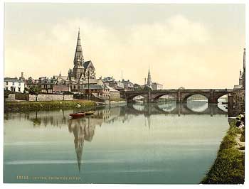 |
| Photo from the Detroit Publishing Company's Views of Landscape and Architecture in Scotland - see thumbnails on Library of Congress site here. |
- the Puddleford near the Kirkgate- Fucans Ford, later to be know as Carford because of the coal cars or carts which used it
- the Marress ford, downstream from this. Stepping stones were laid down here in 1853.
It also had its "gates": Sandgate, Seagate, Kirkgate and Bridgegate, all of which date from the middle ages. There was a Townhead Port and the Westport. Mention is made in 1506 of a route to Kilwinning. Routes to Ayr and Kilmarnock and possibly up towards Beith were likely.
The
bridge at Irvine was probably first built of wood in
the 14th century and later, certainly by 1533, of stone.
W Walker in his History of Irvine and McJanet in his
book the Royal Burgh of Irvine give full details of
the history of the bridge.(11,12)
It is suggested that the growth
in the population and the economy when the harbour was
built led to the need for a bridge. Prior to that time
the ford was adequate.
Brig O'Doon at Alloway
 Other
bridges known from this time are Alloway, probably a
little later than Ayr (cf. Alexander's reference to
a bridge, above) and also replacing a wooden structure,
Girvan and as said, Bardrochat near Colmonell and at
Kilwinning. It is unlikely that these were the only
bridges as it was common for the church and major landowners
to build them as acts of piety. The presence of a bridge
over the Doon at Alloway is clear confirmation of a
route to the south, as is that at Girvan.
Other
bridges known from this time are Alloway, probably a
little later than Ayr (cf. Alexander's reference to
a bridge, above) and also replacing a wooden structure,
Girvan and as said, Bardrochat near Colmonell and at
Kilwinning. It is unlikely that these were the only
bridges as it was common for the church and major landowners
to build them as acts of piety. The presence of a bridge
over the Doon at Alloway is clear confirmation of a
route to the south, as is that at Girvan.
| Sherrifdoms |
It is of note that there was hardly any legislation on roads in this period. William the Lion had a rule of the road for horsemen or men leading horses or cattle if they met on a bridge or narrow path. David II enacted that the king's highway should be forty feet wide and that no one should encroach on it. Nothing else appears until 1555, when an Act was passed against encroachment or stopping up of highways leading to burghs and ports. This was strengthened by another Act in 1592. (13)
| Feudal System |
The
list below gives the Ayrshire parishes of the period,
up to the time of the Reformation, along with the date
they were first mentioned. (14,15)
Those in Dillon's list are marked
with an asterisk and it is quite easy to separate them
into his 'ton', 'kil/kirk' and 'other' groupings.
| *Alloway pre-1501 - a pendicle of Ayr | *Beith pre-1286 | *Monkton pre-1165 & Ladykirk (a chapel within Monkton) | *Stevenston late 12th century |
| Kilbirnie pre-1410 | Colmonell (Kilcolmonell) pre-1179 | *Dalmellington pre-1501 - a pendicle of Ayr | *Dunlop -15th century |
| *Ardrossan pre-1226 | *Largs pre-1170 | *Ochiltree 13th century or earlier | *Stewarton 12th century |
| Kirkbride pre-1185 | *Coylton pre-1501 - a pendicle of Ayr | *Dalry pre-1226 | *Galston pre-1470 |
| *Auchinleck pre-1238 | *Loudoun pre-1238 | *Pierston pre-reformation | Straiton pre-1233 |
| Kirkcudbright-Innertig (Ballantrae) 13th century | *Craigie circa 1177 | *Dalrymple pre-1501 - a pendicle of Ayr | *Girvan (Innergarvane) and its chapel of Kirkdominie pre-1236 |
| *Ayr pre-1327 | *Mauchline pre-1178 | *Riccartoun pre-1221 | *Symington 1160 |
| Kirkmichael pre-1381 | *Cumnock pre-1401 | *Dreghorn (Landregarne) -pre-reformation | Inverkip pre-1170 |
| *Barnweil pre-1335 | *Maybole pre-1214 | St Quivox pre-1221 | *Tarbolton pre-1335 |
| Kirkoswald pre-1214 | *Dailly pre-1214 | Dundonald pre-1221 | *Irvine pre-1323 |
As the map shows, the location of the churches helps to provide additional evidence for certain routes or suggests other routes.
 On
a more local level, there would have been tracks from
farms to the central point of the vill. As churches
were usually found there, these tracks would serve for
this purpose as well. As an example of a local track,
there is an intriguing reference in a c.1290 charter.
It mentions a holloway just east of Dundonald which
seems to have been the route to Symington.
(16)
Dundonald was where the main vassal for Kyle had a major
stronghold and Symington was originally Simon's ton.
As a holloway, essentially a track loosened by the passage
of traffic and eroded by rain takes considerable time
to form; this could have been an early route. It could
even date back to the dark ages and Aeron because of
the association with the stronghold at Dundonald. As
mentioned in the last section, an old road was traced
between Dundonald and Troon. There, it was suggested
it might date from the Dark Ages but given the prominence
of Dundonald in mediaeval times, it could be from this
time.
On
a more local level, there would have been tracks from
farms to the central point of the vill. As churches
were usually found there, these tracks would serve for
this purpose as well. As an example of a local track,
there is an intriguing reference in a c.1290 charter.
It mentions a holloway just east of Dundonald which
seems to have been the route to Symington.
(16)
Dundonald was where the main vassal for Kyle had a major
stronghold and Symington was originally Simon's ton.
As a holloway, essentially a track loosened by the passage
of traffic and eroded by rain takes considerable time
to form; this could have been an early route. It could
even date back to the dark ages and Aeron because of
the association with the stronghold at Dundonald. As
mentioned in the last section, an old road was traced
between Dundonald and Troon. There, it was suggested
it might date from the Dark Ages but given the prominence
of Dundonald in mediaeval times, it could be from this
time.
Another important reason for making journeys was taking the corn to the local mills - tenants were usually required to do this as one of the conditions of tenure. In a study of the cornmills of Ayrshire, James Wilson gives much detail of these mills, including the early ones. (17) As examples of mills that can be dated to this period there is:
Helenton - pre-1583
Monk's Mill - linked to Fail\Mill O'Shiel - 1300s
Millmannoch - mentioned in 1373
Trabboch Mill - 14/15th Century
Mill O'Ness - mentioned in 1359.
It is of course difficult to know where these tracks were as it is not until Pont's maps of circa 1600 that we have a clear idea of what farms existed at that time - prior to that we can only use occasional mentions in records. Even then it would require considerable research to identify which mills were used by which farms.
| The Church |
| Paisley Abbey |
 One
point of relevance to Ayrshire is that Paisley Abbey
had the lands between the Maich and Calder so that it
is highly likely that the route using the toll point
of Maich must have come through here - the Ayrshire
boundary is at the Maich. There was a bridge at Brigend
(in Lochwinnoch) over the Calder said to have been mentioned
in the Rental Book in 1525 (NMRS
record), although at the present day it is much
altered. It is also shown on Pont's manuscript map of
the 1590's (he also shows another bridge downstream,
nearer to Lochwinnoch) and it is certainly tempting
to assume it was built by the abbey to serve their lands.
One implication of Paisley holding these lands is that
is that if they journeyed from here to Paisley, it must
have been possible for those using the toll point of
Maich to do this as well.
One
point of relevance to Ayrshire is that Paisley Abbey
had the lands between the Maich and Calder so that it
is highly likely that the route using the toll point
of Maich must have come through here - the Ayrshire
boundary is at the Maich. There was a bridge at Brigend
(in Lochwinnoch) over the Calder said to have been mentioned
in the Rental Book in 1525 (NMRS
record), although at the present day it is much
altered. It is also shown on Pont's manuscript map of
the 1590's (he also shows another bridge downstream,
nearer to Lochwinnoch) and it is certainly tempting
to assume it was built by the abbey to serve their lands.
One implication of Paisley holding these lands is that
is that if they journeyed from here to Paisley, it must
have been possible for those using the toll point of
Maich to do this as well.
Paisley also had holdings in Ayrshire in Monkton and
Prestwick and Dalmilling, prior to those lands being
passed to Crossraguel Abbey. Again, journeys can be
assumed although the routes they would have used are
uncertain.
Hall notes a grange at Auchengrange about 4 km north of Beith (Derek Hall, Scottish Monastic Landscapes, page 134). It is about 1 km outwith the Ayrshire boundary but its location suggests an easy route to Paisley, perhaps from Beith itself.
Note: For more information about Paisley Abbey and its holdings, mostly in Renfrewshire, see here.
| Kilwinning Abbey |
 |
| Kilwinning Abbey |
Unfortunately, the records of Kilwinning Abbey have been lost. They were collected assiduously in the 19th century for publication in the collections of the Ayrshire and Wigtonshire Archaeological Association but were lost at the demise of that organisation.
We can, however, find mentions here and there of lands that belonged to the abbey and can, to a certain extent, presume that the parish boundary will reflect in places the boundaries of some land grants, given examples from elsewhere - see for example, Maybole below. Indeed Cowan (18a) notes that they had the whole parish with the exception of the lands of Eglinton and Montgreenan. They also had land in Beith and a few properties elsewhere.
 There
was a track in the mid 1500's to Goldcraigs (about 2 miles
NE of the abbey near Monkreddan) as the Abbey had a quarry
there and the abbey had three mills to which their tenants
had to take their corn: beside the bridge in the town;
Craigmill near Dalry (on Caaf Water, 1 km SSW of town);
and Seven Acres Mill in the north-east of the estate.
Dalgarvan
Mill (2 miles north of Kilwinning) had also belonged
to Kilwinning; it was known as "the walkmyln of Groatholm".
There
was a track in the mid 1500's to Goldcraigs (about 2 miles
NE of the abbey near Monkreddan) as the Abbey had a quarry
there and the abbey had three mills to which their tenants
had to take their corn: beside the bridge in the town;
Craigmill near Dalry (on Caaf Water, 1 km SSW of town);
and Seven Acres Mill in the north-east of the estate.
Dalgarvan
Mill (2 miles north of Kilwinning) had also belonged
to Kilwinning; it was known as "the walkmyln of Groatholm".
There was also a route to Irvine as they had a house there for conducting business. In 1439 the Abbot of Kilwinning received Based on 1935 OS map. With thanks.
permission from the Pope to collect monies to build a bridge. (18)
The map shows some likely routes though the actual network would have undoubtedly been more extensive.
| Crossraguel Abbey |
 |
| Crossraguel Abbey |
In the early 13th century, Duncan, later Earl of Carrick, granted some lands including Crossraguel along with the churches of Dailly, Straiton and Turnberry to Paisley Abbey. This however was on condition that Paisley found a monastery in the area and to which these endowments should pass.
Paisley was slow in complying with this condition and it was only towards the end of the century that Crossraguel was built and became a fully functioning abbey. Its relations with Paisley were always difficult.
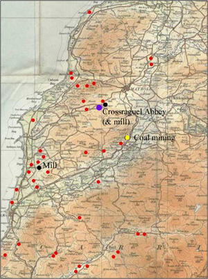
The abbey was on the pilgrim route to Whithorn, where travellers could stop and rest. We can assume considerable movement to and from the abbey, particularly in regard to lands that it owned. The map below is based on that shown in the Charters of Crossraguel (19) which shows principal places mentioned in the various charters, and is suggestive of several routes.
 |
| Lands
owned by Crossraguel Abbey Reproduced from 1935 Ordnance Survey map. � Crown copyright |
The cluster to the west of Maybole suggests a fairly direct route to the abbey (an annual court was held at Auchenblane near to the abbey) while those farms near Dailly may have had a route over the hills where there were later routes and where the walking would have been relatively easy. The cluster north of Girvan would have found access to the abbey easy by going through Kirkoswald or keeping to the high ground. South of the Water of Girvan is more speculative but routes through Girvan, Old Dailly, and Dailly are possible. Five churches belonged to the Abbey, viz. Girvan, Ballantrae, Straiton, Dailly and Kirkoswald and these also suggest routes. There were mills at Crossraguel itself and at Drumgarloch (probably on Lady Burn, 2 miles south of Turnberry - see Ainslie map) - one or other of these mills had to be used by tenants.
Of particular interest is the fact that coal mining was carried out at Yellowlee, thought to be near Craigoch, four miles south of Maybole and about the same distance from Crossraguel.
| Fail |
This religious house was founded in the mid-1200s by an order dedicated to the release of those captured in the Crusades.(20a, 20b) Although not a monastery, it had considerable lands in the area and journeys to outlying farms can be assumed. Two connections with roads are that there was a spittal here on a likely route from Galston to Ayr where travellers could rest and that the "Monk's Road" ran from Mauchline to the vicinity of Fail (see below).
| Melrose Abbey |
Mauchline
 |
| The Monk's Tower, Mauchline |
Throughout the middle ages, the monks of Melrose were gifted considerable tracts of land in central and eastern Ayrshire. An administrative centre was set up in Mauchline to manage the large estate. The account books for 1527-1528 survive and contain references to travel. (21) The area was fairly well settled with nearly 40 named homesteads and these are strongly suggestive of tracks or routes to Mauchline perhaps in some cases on older lines. To the east one would suspect two routes, one linking those living up the Greenock Water, and the other linking those on the upper reaches of the Ayr. From Greenockton, where there was a tower, a route north of the Ayr would bring them to the cluster near Sorn and the nearby mills, and Mauchline itself. To the north, two or three fairly short routes could be postulated and the same to the south and west.
There was regular contact with Melrose and a number of local men were employed as messengers by the Chamberlain to undertake business journeys on his behalf to Glasgow, Lanark, Irvine, Ayr, Loudoun, Crossraguel, Dunure, Ardmillan, Cassilis, Dunscore, Melrose, Edinburgh and Dunfermline. In 1521, a load of fish was brought in from Irvine which implies a track capable of taking carts. Of particular interest is a charter quoted by Sir William Fraser, in Volume 3 of the Douglas Book that records a dispute over a right of way through the Douglas valley in the late 1200s. Melrose had a centre at Tordones, which must be Tardoes in Muirkirk, from where they took produce to Melrose by Douglas, Uddington and Wiston. Sir William Douglas challenged their passage through his lands but lost in favour of the abbey. For more details see here.
The area, known as the Barony of Kylesmure, was so extensive that chapels of ease were created at Dalgain (Sorn) and Moorkirk (Muirkirk).
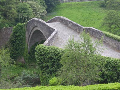
The Monk's Road
A paper by James P Wilson (AANHAS) gives an account of a road said to have run from Mauchline over to the lands of Barmore and Godeneth, gifted to the abbey by Richard Wallace of Riccarton in the 13th century. (22) These lands were near Fail. Unfortunately he does not give references so it may be he is reporting a local tradition. There was a road along the route he describes which is shown on the Military Survey map of c.1750 but this does not necessarily mean that it was built by the monks as it could have been built under the statute labour system. In principle, however, it is a possibility, especially given the abilities in road building of the Cistercians.
 |
|
Course of the "Monk's
Road", as shown on the Military Survey map
of c.1750. Based on 1925 1" OS map. |
The boundaries given in the charters are difficult to identify although Barmuir farm exists today. For our purposes we only need to know that they were to the east of Fail (the boundaries have now been identified - see Tracking down a lost parish, Gilbert M�rkus, 2009). The course of the road as given by Wilson was from a ford at Fail (south of the sharp bend at Redrae) and then running south of the present road past Mosside (where Roy and Thomson show a distinctive turn - probably the same as that shown on present day maps). Beyond Mosside, it must have been on or near the present road and then the track (see photo) south of Millburn where any trace is lost. From here, it seems to have run over to near Mossbog and then taken the line of the modern road past Skeoch and Mossgiel to Mauchline.
 |
| The remaining section of the" Monk's Road" |
It is likely that this was the correct route as it is the same as the road shown on Roy and a section lifted by the 4th Duke of Portland about 1800 was from near Largie (just above Ladyard) past Mossbog to the high ground south of Millburn. Here the owner of Millburn blocked him but he continued the removal of the road half a mile further on between the Long Wood and Mosside. Wilson says that the road here ran at an angle through the fields and that the rest of the road was lifted about 50 years later.
It is not known when the road was built but could easily have been as early as the 1400's. It does raise the question as to whether any other roads near Mauchline had their origins at this time and if they were actually made.
Maybole
Melrose had also been granted extensive holdings
in the Maybole area as well as saltpans on the coast.
These were initially at Greenan and later near Turnberry.
The Maybole territory lay to the north of the town where
even today the placenames of Grange and Monkwood survive
to indicate this. They were also granted the territory
of Bethoc, now Beoch, and lands along the coast near
to Largs (Largis) and Dunduff.
 |
| Melrose lands in Maybole. Based on 1914 half-inch OS map. With thanks. |
From our point of view these charters are interesting because they mention three roads (via), one of which was a wagon road, as well as a path (semita). However, parts of the charters are very difficult to interpret both because of their vagueness and placename changes which makes it difficult to determine the course of the roads with any exactitude. The charters are detailed below with some notes on problems with their interpretation and on the possible location of the roads.
Maybole
 |
| Looking towards the Howmuir |
The Maybole boundaries ran as follows:
|
Charter 29 "from
the head of the burn which descends from Crumden
down as far as Culelungford and as the same burn
descends from Culelungford to the polnetiber and
as the polnetiber falls into the Doon. And by
the Doon upwards as far as where polygarroh falls
in the Doon and so upward by the polnegarrah as
far as a little moss* and thence to a certain
syke which descends from the southern part of
the same moss to the polnegarrah and by that syke
upwards as the same syke ascends to the polnecgarrah
and polnecgarrah ascends in Duvah and then up
by the syke to the road which is called Enahconecal
and by the same road down as far as the burn which
descends from the previously mentioned Crumder." |
Interpretation
James T. Gray (Maybole, Carrick's Capital Facts, Fiction & Folks - on Maybole website) identifies the placenames of the charter and says that the lands ran down a stream (presumably Garryhorn Burn) from Crumden which he says was near the rifle range north of Trees as far as Culelungford which he places near Garryhorn Farm. The Polnetiber can only be the Culroy Burn which flows into the Doon at Auchendrane. The boundary then follows the Doon upstream where the Polnegarrah, using the parish boundary as a clue, must be the Chapelton Burn. It followed this up to a "little moss" which Gray places between Laigh Smithston and Laigh Grange - a marshy area is shown on the Military Survey south of Laigh Grange. The Duvah of the charter may have been near Slateford. The boundary then continued in a westerly direction to Crumden.
Despite the apparent clarity of the charters, it is difficult to determine where this road ran other than that it was near Brochloch, Trees and Enoch. The name "Enahconecal" is strongly suggestive of Enoch although this would take it away from Crumden. Another possibility is that as aonach means high in Gaelic it may have been a road leading to high ground. The road and track leading from Maybole over to Kirkbride near the coast could be consistent with the section of the second charter that talks about the road leading up to the stream above Crumden, with the boundary then following the Garryhorn Burn downstream to Crumden.
Bethoc (Beoch)
The lands of Bethoc ran from:
|
Charter 29 "Lemenelung
eastwards by the road as far as Neskecokeri and
from there eastwards to a great spread of willows
and from thence downwards from the northern part
of Croah parvi to Gallan and from there eastwards
to a syke which goes from the northern part of
the black rock and from the same sike to the place
which is called Tundregaith where from this syke
to a certain river which is called Polnesalahart
and from there as the same river falls into the
polnetyberes." |
Interpretation
 |
| Near Beoch, looking towards White Craig |
There are so many difficulties in interpreting these two charters that it is probably best not to speculate where the boundaries and the road ran. A couple of points can be made however. Although the wording is different in each, they are probably describing the same lands. Certainly the latter parts of each charter seem the same and with one or two substitutions the first parts seem the same, for example, Neskecokeri and Scipsate which have a road going to them, the moss and the willows, Croah parvi and Altecreve.
Another point is the location of Tundregaith. Gray places it on the Sauchrie Burn (polsalacharic) yet early maps (see NLS Ayrshire) show a place near Drumshang called variously Tonrach, Tannergie, Tonraghe and Tundergree. Croah parvi/Altecreve looks very much like Croy and Gallan looks like Culzean. Cragan or the "black rock" (niger rupis) could be Blacktop Hill (which is very close to the headwaters of the Sauchrie Burn) though the possibility that it could be Brown Carrick Hill or Brown Craig has to be kept in mind.
In general terms, given that the following charter clearly deals with land north-west of Beoch, roughly north of the Sauchrie Burn over to Dunduff, the above charters must cover land south of this line and more directly west of Beoch. The boundary to the south, or more properly the south-east should be that given in the Maybole charter, viz. down the Garryhorn Burn.
Finally a key point has to be the location of Lumenelung, which Gray identifies as the "Spout of Lumling", somewhere on Howmuir. There are several springs and waterfalls in that area but it is not clear which it might be.
Drumeceisuine, Alesbruc and Auchnephur
This was a charter in the time of William (1165
- 1214). The boundaries were:
|
"as a burn descends from
the moss which is between Largas and Bethoc and
divides between Dunduff and Drumceisuine and by
the same burn as far as that place that the same
burn falls into the sea and from there by the
shore to Alesburc and from Alesburc to a syke
which descends from the wood on the eastern part
of the wagon road and climbs to Auchnepur and
by the same sike ascending by a certain deep valley
as far as a certain old fortress and from the
eastern side of the same old fortress by a sike
up to Gilliforde and from the northern part of
the source and passing over upwards as far as
a sike which runs from the northern part of Fanilee
and up by a syke to a path (semita) and by that
path up to the head of a sike which falls into
the polnesalahi to Havenegaith." |
Interpretation
 |
| Looking towards the top of Sauchrie Burn |
The
only recognisable placenames are Largs, Dunduff and
the Sauchrie Burn. However, we know the boundary reached
the coast by a stream that served as a boundary between
Dunduff and Drumceisuine and climbed up again by another
to reach an old fort. The only fort in the area is 200
metres WSW of Dunduff Castle. If the valley was the
one to the west of the fort this could be consistent
with the track that runs between Maybole and Kirkbride
being the "wagon road". There are a couple
of stream east of the fort that could have led up to
"Gilliforde", which name implies a track.
The path that the charter mentions must have been near
the headwaters of the Sauchrie Burn nearby, though its
orientation is uncertain.
Conclusion
As said, there is a great deal of ambiguity about the charters and the above interpretations are quite speculative. There is, however, a hint that the present day road and track running from Maybole to Kirkbride may have existed at that time. Although it does not appear on maps until Thomson in 1820 and then only from Maybole to the Garryhorn Burn, strictly speaking this is not proof that it did not exist at an earlier time, i.e. "the absence of evidence is not evidence of absence." It does have a logic in the context of the Anglian settlement of the Maybole area especially as Alesburc (cf. Brooke) is mentioned and Kirkbride could easily have served settlements in the coastal area.
Early Droving
In their book, Melrose Abbey (Tempus Publishing, 2008), Richard Fawcett and Richard Oram, make the interesting suggestion that Melrose may have driven cattle and sheep down from Mauchline to their lands in Nithsdale (Dunscore) and onwards to Dumfries and Carlisle - the abbey had other properties in Dumfriesshire that could have been used as staging points for these journeys. Their idea is based on a charter of 1250 giving Melrose the right to pass through the lands of Dalswinton and Duncow with their cattle and carriages. If the way was damaged by flooding or their wagons they could repair it "per fossas and calceas) - the term calceia implying a "made" road. (Liber Melros, vol. 1, charter 319, page 280).
The natural assumption is that this right of passage was for journeys to and from Melrose along the old Craik Cross Roman road which would be easily reached by a ford at Dalswinton and crossing over to Lochmaben and then up Dryfesdale. However, as Fawcett and Oram show, it could easily have been in order to facilitate movement from Mauchline to Dumfries and Carlisle.
The direct route from Mauchline would have been down the Nith valley from where Dunscore could easily be reached. The Nith would have been forded at Dalswinton for onward journeys.
Dalmellington and Keresban (Carsphairn)
In the early 1200's Thomas Colville rented a large tract of land in present day Dalmellington and Carsphairn to Vaudey Abbey in Lincolnshire. Vaudey found it difficult to manage, mentioning problems with the native population and came to an agreement with Melrose. It is noteworthy that Vaudey obtained permission from Henry III to import grain from Ireland for their needs which indicates their use of the "pack road" down to the Solway coast (see The Ayr-Kirkcudbright Road).
In turn, Melrose managed the land and as Fawcett and Oram (Melrose Abbey, Tempus Publishing, 2008) suggest, may have exploited the area for coal, iron and lead. After only a few years they negotiated an exchange for land in the Lammermuirs, perhaps because Carsphairn was too remote.
It is not at all clear what routes they would have used. If there was contact with Maybole the easiest route would probably have been over to Straiton perhaps by one of the old hill tracks that come out south of Straiton itself. If the main contact was with Mauchline there would be fairly direct routes over towards Cumnock or perhaps the old route to Littlemill. These suggestions are of course speculative, though there must have been contact with one or the other. Also speculative is any link with the road that ran near Windy Standard (see The Ayr - Kirkcudbright Road) although again there must have been a route or routes that they used in the short time they were in the area - certainly the "pack road" could easily have been used both to reach Ayr and the Solway.
| Spittals |
This is a fairly common placename in Scotland and can denote either a hospital or a hostel, that is, a place where travellers could rest from their journeys. As such they are an indication of an associated route and are often found beside fords and bridges where a traveller could wait if the river was in flood. Religious establishments usually provided them as a pious act.
In Ayrshire there were a number of spittals, five of which are mentioned in historical documents and four others which are conjectured. (23) Three are near fords - Kincase on the old shore road between Irvine and Ayr, near to the Pow Burn; Doonslee between Ayr and the Doon near a ford over the Slaphouse Burn; and Failford. There were also spittals at Symington and Maybole. These are strong indications of old routes between Irvine and Ayr, a north-south route running through Ayr, and one over to Lanarkshire via Fail, Galston and the Irvine valley.
Those not verified are Mauchline, Irvine, Stewarton and Kilmarnock although that at Stewarton is near Kingsford where there may have been an old route. It also has to be noted that not all spittals catered for travellers although it is likely enough that those mentioned above, being so close to routes, did have this function.
| Pilgrim Routes |
One pilgrim route was northwards towards Govan where there was a shrine to St Constantine at Govan, Paisley with St Mirrin and Glasgow with St Mungo. It is likely that David I promoted the veneration of Mungo to take attention away from Govan which had been a centre of the British kings of Strathclyde. (24) These imply a route either up the Garnock or over the moors near Fenwick.
The other route (more properly routes as there seems to have been two or three) was to Whithorn in the south. It was certainly well established by the 1300's when Crossraguel, a daughter house of Paisley was set up in 1244 on the route where pilgrims could rest.
Bardrochat, above the present bridge over the Stinchar at Colmonell may have been an early bridge for pilgrims. Drochat is from the Gaelic drochaid meaning bridge and Reid says that there were a number of wooden bridges over the Bladnoch, west of Wigton, primarily for the use of pilgrims, which were swept away by floods in 1441. Margaret, Countess of Galloway, obtained a Papal Indulgence for those who assisted her to build a stone bridge. (25)
Other clues to the route or routes to Whithorn are two occurences of Killantringan (St Ninian's Church). One is a loch near the head of Glenapp on the Girvan-Stranraer road near Auchencrosh (Field of the Cross). The other is a farm (NX 262811) on the Girvan-Newton Stewart Road (which did not exist at that time). McQueen suggests a 12/13th century date and surmised they may have been chapels for pilgrims. (26) There was also a chapel of St Ninian near Ardstinchar Castle. The farm on the Girvan-Newton Stewart road is about 6 miles north of the Laggangarn Standing Stones (NX 222716) on which Christian crosses are inscribed. These stones are thought to have been on one of the pilgrim routes which in the middle ages at least probably led to Glenluce Abbey where they would get shelter and food on their journey. Lepers from the abbey are said to have travelled to the Well of the Rees just a few hundred metres north of the stones to drink its restorative waters. This would make the route hereabouts on or very close to the Southern Upland Way. There are similar marked stones on the "pack road" south of Carsphairn.
| The Later Middle Ages |
An important factor affecting the network of routes was the creation of more burghs throughout the middle ages. Pryde gives full details of the burghs and the economic rivalry between them and Ayr and Irvine. (27) They obtained local trading rights at the expense of Ayr and Irvine, and so encouraged local journeys to their weekly markets. Burghs dating from this time are Newmilns in 1490, Auchinleck in 1507 (although it remained a burgh only on paper - a "parchment burgh"), Cumnock in 1509 and Mauchline in 1510, although it seems to have had trading rights much earlier than this because of the connection with Melrose Abbey. Maybole became a burgh in 1516, Kilmaurs in 1527, Saltcoats in 1529 (delayed until 1576) and Ballantrae in 1541 (also delayed for a few decades). Finally there was Kilmarnock in 1591-2 and Largs in 1595. It was known as Newtoun of Gogo and Pryde refers to a market near the church where "Irishmen, natives and strangers were wont to gather" prior to the formation of the burgh. Such unofficial markets seem to have been quite common. As an aside, Barbour in his Life of Bruce refers to a journey up the coast past Largs, and Inverkip castle being "wel stuffit wi' Inglischmen".
It is unlikely that the markets associated with these burghs would have been responsible in themselves for roads but taken in conjunction with trips to the church, the local mill and the town itself would have been a factor in the growth of local networks. As noted, laws were passed in 1555 and 1592 about impeding travellers on highways to burghs and ports. (13)
| Timothy Pont |
 A
useful source for roads of the late 1500's and early
1600's are the maps of Timothy
Pont, which were published in atlas form in 1654
by the Dutch cartographer Blaeu. The survey, however,
was carried out earlier than this, and that of Ayrshire
probably dates from the 1590's. Although he does
not show any roads for Ayrshire he does include
river crossings, whether ford or bridge, and provides
a host of placenames some of which refer to roads
or at least tracks. There are also lists of distances
between places which have survived and although many
date from the 1640's when work on the Blaeu Atlas
was progressing some were recorded by Pont. These
lists are quite different in character from other entries
which lists places in relation to other nearby
places. It is highly likely that these lists entail
routes between these places: the known mileages must
have been gained from actual travel and there would
be little point in knowing the distances between places
unless people were travelling between them. In addition,
some of the entries list intermediate points between
centres as if they were on a route, and there are entries
like "five miles from Maybole on the way to the Chapel
(near Stranraer), three standing stones in the highway,
and on the way to Largs."There is a reference
to two routes between Glasgow and Irvine and that one
was shorter than the other and also references to milestones
north and south of Ayr. In any case there is often evidence
from other sources to support the idea of a network
of routes at this time and Pont himself on his original
maps shows bridges and fords that could only have been
used for travel. These sources are dealt with below.
A summary map is provided below - as the routes are
based on the lists of distances some routes that may
have existed at the time (for example Dalmellington
- Ayr) are not shown.
A
useful source for roads of the late 1500's and early
1600's are the maps of Timothy
Pont, which were published in atlas form in 1654
by the Dutch cartographer Blaeu. The survey, however,
was carried out earlier than this, and that of Ayrshire
probably dates from the 1590's. Although he does
not show any roads for Ayrshire he does include
river crossings, whether ford or bridge, and provides
a host of placenames some of which refer to roads
or at least tracks. There are also lists of distances
between places which have survived and although many
date from the 1640's when work on the Blaeu Atlas
was progressing some were recorded by Pont. These
lists are quite different in character from other entries
which lists places in relation to other nearby
places. It is highly likely that these lists entail
routes between these places: the known mileages must
have been gained from actual travel and there would
be little point in knowing the distances between places
unless people were travelling between them. In addition,
some of the entries list intermediate points between
centres as if they were on a route, and there are entries
like "five miles from Maybole on the way to the Chapel
(near Stranraer), three standing stones in the highway,
and on the way to Largs."There is a reference
to two routes between Glasgow and Irvine and that one
was shorter than the other and also references to milestones
north and south of Ayr. In any case there is often evidence
from other sources to support the idea of a network
of routes at this time and Pont himself on his original
maps shows bridges and fords that could only have been
used for travel. These sources are dealt with below.
A summary map is provided below - as the routes are
based on the lists of distances some routes that may
have existed at the time (for example Dalmellington
- Ayr) are not shown.
Roads in the early 1600s based on lists of distances and showing route indicators from Timothy Pont's maps
 Reproduced
from the 1935 Ordnance Survey map. � Crown copyright
Reproduced
from the 1935 Ordnance Survey map. � Crown copyright
| River crossing | Placename | Listed route |
| River Crossings |
River crossings shown are as follows:
| 1. Glen Water near to Bankhead Farm above present day Darvel | 13. a crossing of the Carmel Water near Kilmaurs |
| 2. across the Irvine at Greenholm | 14. Crosshouse |
| 3. two crossings over the Cessnock Water in Galston | 15. Stewarton |
| 4. a crossing near Mauchline | 16. "Bridgend" over the Doon, probably Alloway Bridge |
| 5. a crossing over the Ayr near the present bridge close to Mauchline Creamery | 17. the bridge at Ayr |
| 6. "Bridgend" on the Burnock Water, a couple of miles south of Ochiltree. This is presumably near the ford at Barquharrie Farm | 18. five bridges over the Curtecan Burn south of Ayr |
| 7. a crossing just north of Ochiltree | 19. two crossings near Martnaham Loch |
| 8. a crossing over the Girvan Water at Girvan, with a "Bridgend" on the north side and a "Brigend" on the south | 20. crossings both east and west of Cassilis (NS332129) at Burnmouth on the present Kirkmichael road and near Netherton just south of Dalrymple |
| 9. a bridge at Irvine | 21. a bridge over the Water of Girvan. This is near the present Aird Bridge on an early route from Maybole to Girvan |
| 10. a crossing at Kilwinning | 22. a crossing at Milton near Straiton over the Water of Girvan |
| 11. a crossing at Dalry | 23. Bridgend, near Belston |
| 12. a crossing north of Kilmarnock, probably the ford near Dean Castle |
From these we can infer several routes, viz:
1. Glen Water (NMRS record) It is not certain where the roads were in the vicinity of Loudoun Hill at this time. This bridge (it may have been a ford in Pont�s day) certainly suggests that it itself was on the main east-west route. There is a ford beside it -McLeod in the Book of Old Darvel refers to an old grass-grown cart road above the ford over the Glen Water. (28) This ties in quite well with the holloways at Allanton Plains leading towards the Loudoun Hill area where there was a fording point on the Irvine just north of Wallace's Knowe. The road could then have gone south of the hill heading for the Glen Water but could equally have gone just north of the hill which is on a more direct route. What tells against this slightly is that Wallace used the fort (south of the Irvine) for his ambush at the Windy Wizzen on the present A71 which implies the orientation of the holloways could just be coincidental and that the road ran towards the fort rather than Loudoun Hill - this is the course that would be expected in Roman times anyway. From there it could have crossed at Passford (not shown on Pont) and headed up past Henryton to the Glen Water crossing.
There is no trace of the Glen crossing on Roy and Armstrong who both show the road as running from Priestland past Gorsebraehead and Coathill to join the present A71.
 |
 |
Old bridge at Darvel. There is an adjacent track leading to a ford - the stones appear to have been placed in thestream to make it shallower |
|
2. Greenholm To the west, Roy
shows the road running through Darvel and Newmilns to
Galston and beyond, that is, along the line of the A71.
The question is, was this the case in Pont's day, or
did it run along the high ground from the Glen Water,
perhaps towards the old road between Dalwhatswood and
Clearmount? We ask the question because Pont shows a
bridge at Greenholm (Newmilns) which is almost certainly
on the line of the route to Ayr at that time.
(29)
If it is, it implies the road ran down from the high
ground and then to the south of the Irvine to Galston
where there were other bridges. Strawhorn's comments
on this are interesting - he suggests a route from Irvine
could have met the Ayr route and that this could explain
why Newmilns existed from an early date; he also suggests
the street layout of Galston is best explained by assuming
the Ayr route was to the south of the river, suggested
in any case by the bridge. By 1750 there is no trace
of this road on Roy's map who shows the Ayr route to
the north of the Irvine, crossing at Galston and then
heading roughly along the line of the present road to
Crossroads and Fail.
3. Galston If the Ayr road ran to the south of the Irvine there was a bridge near Barr Castle in Galston and another just to the north of it. These imply the route went via Woodhead (near the present Crossroads) and Carnell, with another route heading to Mauchline.
4. Mauchline This is shown just north of the centre of Mauchline itself and may relate to a route from the Kilmarnock area.
5. Bridgend, Mauchline This is at the location of the present bridge at Barskimming. The same crossing point is shown on Roy who has a road running to Ochiltree.
6. Brigend, south of Ochiltree Although it would be nice to link this up with Armstrong's "lost road" between Ochiltree and Littlemill with its suggestive Rottenrow (route du roi) and Glenconnor (conaire - a path), it lies over a mile to the south-east of this route. The most likely spot for his crossing is just above Burnock Mill and it may just have been for local needs - there was a Neumill nearby.
7. North of Ochiltree A crossing is shown very near to Ochiltree but as it crosses a minor stream rather than the Lugar and there is a mill on the other side, it may only be of local significance.
8. Girvan The crossing at Girvan seems to be near the old bridge which can be seen today from the new crossing north of the town. Its existence clearly implies a north - south route. There is a Bridgend on the north side and a Brigend on the south.
9. Irvine A wooden bridge is thought to have been built here in the 14th century, later replaced by the stone bridge which is what Pont would be showing. Earlier there had been a ford. It may have had more to do with the town itself than with a long distance route though it would have provided an alternative route to Ayr, certainly for the first few miles. Green in 1679 has such a route past Dundonald and Monkton to Ayr.
10. Kilwinning This may well be the bridge built in the mid-1400's by the Abbey. It would have facilitated travel to Irvine as well as serve local needs but it is difficult to say if it had wider implications for routes such as leading to the toll point at Maich.
11. Dalry It is difficult to tell where it was because of the mapping but one possibility would be a crossing of the Garnock north of the Bombo Burn, but south of the Rye Water. This would place it just east of the town and would be consistent with his showing of a stream north of Blair (Bombo Burn). He also shows a "brig" near here which may have been over the Rye.
12. Kilmarnock This appears to be over the Fenwick Water somewhere near Dean Castle. As it is shown entering the estate it may have been for local use only.
13. Kilmaurs From the map this seems to have been over the Carmel Water just south of the mill which is on the present Fenwick Road. It could be indicative of a road from Kilmarnock - certainly Roy shows one 150 years later. Equally, bearing in mind Green's road of 1679 from the Irvine Valley over to Cunninghamhead, it could be linked to an east-west route.
14. Crosshouse This crossing is on a logical route between Kilmarnock and Irvine and there are records of work on a road in 1695. It must have been very close to the crossing of the Carmel at Crosshouse.
15. Stewarton This crossing is of the Annick Water just short of the present crossing which leads up to Nether Robertland. Roy has a road from Kilmarnock up to Glasgow (on the line of the B769) on this alignment so it is not impossible that this was on an early route to Glasgow.
16. Alloway Bridge This afforded a crossing of the Doon on a long used route into Carrick and Galloway. He shows a "Bridgend" at the bridge.
17. Ayr This is the "old brig", now renovated and used as a footbridge.
18. Curtecan Burn, Ayr Five crossings are shown and as the map is of much the same period covered by Strawhorn it should be possible to relate the crossings to the roads mentioned above. Starting from the coast, the first crossing is probably the shore road where a new bridge was built in 1546. The next crossing must be on the road between Alloway and Ayr. The third is just downstream of a confluence of the Curtecan and another burn which would place it just north of Rozelle Park - it is hard to tie this to any of the roads. The fourth is also hard to identify. It seems to have been roughly on the line of the present Dalmellington Road but it is the fifth bridge which may have been on the Dalmellington road of the time which Strawhorn says ran past Abbothill and Mosshill, i.e. a few hundred metres north-east of the present road.
19. Two crossings near Martnaham Loch One is shown crossing to an island, the other is at the east end of the loch.
20. Cassilis Two crossings are shown near Cassilis House, south of the River Doon and near to Dalrymple. They are shown crossing streams rather than the Doon and so are likely to be of local significance only, perhaps tracks to mills. One is close to the present bridge north of Burnmouth (NS332128), the other over the stream near Barnsford (NS354135).
21. Aird Bridge, over Water of Girvan The best fit for this crossing seems to be somewhere near Poundland (one mile east of New Dailly) on the B741. There is hardly any doubt that it was part of a Girvan - Ayr route, one which may have ran from Girvan on the south side of the river, crossed, and made its way up to Maybole. If it ran to the north of the river and then crossed to the south side, it would have had to cross the river again to get to Maybole.
22. Milton, near Straiton This is just north of Straiton and the crossing must have been very near to the present bridge. The crossing may just have been to allow access to the mill for those living on the west of the river but it would have facilitated travel over longer distances. Roy has a route from here to Crosshill as well as a route south of Straiton so it is fairly safe to assume such a route in Pont's time.
23. Bridgend, near Belston The best fit for the map is at Bridgend Mains over the Water of Coyle on a minor road running from Stair to Belston on the A70. Although not shown on Roy or Armstrong it would have a certain logic to it as a route between Stair and Ayr. The long ridge on the north side is very distinctive.
To the south of Ayrshire, Pont shows bridges south of Carsphairn over the Ken and Deugh which helps to confirm the Dalmellington -Glenkens route and also at Bargrennan where the road comes down from the Nick of the Balloch. (30)
| Placenames |
As said, he has a number of placenames which refer to roads, bridges and fords. Gate, gait, or a variant yett generally refer to a road and form compounds such as Gateside, Gatehead or Stonygate. It need not entail that the road was "made" as it had the meaning of "a way to" so at this time would probably refer to a track that was defined sufficiently by people using it to justify the name of gate. Bridge is another placename which as Bridgend or Bridgehouse is often at a river. It can also refer to a causeway across marshy ground and there may be one or two examples of this use in Ayrshire. Causeway, causey or calsey implies a made road and Rottenrow is thought by some to derive from Route Du Roi, so referring to a King's Highway. Also relevant are ford and path. Instances of these from Pont's maps are given below.
Stronygait, south of Newmilns, now Stoneygait. This is indicative of a road between Newmilns (where he shows a bridge) and Galston.
Gaitsyid, near Craigie. This must be Gateside just north of Craigie (NS425334). The later maps of Moll (1725), Kitchin (1740) and Roy (c.1750) show a route on this line to Ayr so it is an indication that this route existed around 1600 and possibly earlier. In the middle ages there was a Galston - Ayr route (A719) which this could have joined south of Craigie.
Gaitsid, near Ochiltree. From Pont's mapping, the presumption has to be that this was near to Barturk and Cawhillan, about one mile north west of Ochiltree. A road or track here in late mediaeval times would be consistent with the presence of the monks in Mauchline and the river crossing at Barskimming which Pont shows. Near to Auchinbay the present road runs through a cutting which might be a holloway, indicative of long use. A road shown on Moll's 1718 map passed close to here.
Gaithead, near New Cumnock (NS629145). As the name implies a terminus this may indicate a route from the farm into New Cumnock.
Gaitsyd, near Ayr. This is Gateside at NS371211 just east of the A77 and just north of the A70. Without supporting evidence it is hard to say much about it. It might be that shown later on Armstrong but as no crossing is shown on Pont it may not have run to St Quivox. Another possibility is that it was on an early line of the Cumnock road but given that it is on an existing road this is unlikely.
Gaitsid, near Stewarton. This is Gateside about 1� miles north east of Stewarton (NS434480). It is not clear what road it refers to although it should be noted that Moll in his map of 1725 shows a north-heading route close to here.
Zatt, near Stair (NS432243). This is shown on later maps as Yett which is a variant of Gate/Gait. Although he doesn't show a crossing at Stair, the name Stair comes from the Gaelic for a crossing so there is a distinct possibility that Zatt refers to a route passing through here to the south.
Akengait, near Dundonald. In recent years this farm was sited just above Highfield at NS336343. It may refer to a track to a field or to Auchens (Pont's Aghans) about 1 kilometre west of Dundonald although it could relate to a presumed north - south route between Ayr and Irvine.
Stoneygait, south of Crosshill. This is shown to the east of Blair which lies about 3 miles south of Crosshill (NS323026). In principle it fits well with a route to the south by the Nick O'The Balloch.
Hygate, Straiton. This is Highgate Hill just south-east of Straiton. Although there were several routes in the hills here, best seen on Arrowsmith's map of 1807, this does not seem to be one of them unless the track referred to ran in a north-easterly direction from near Craig over towards the (later) Straiton - Dalmellington road which would fit one of Arrowsmith's tracks. Roy doesn't show a road around 1750, though this is not definite proof that there was no road.
An alternative would be that the "high gate" made its way south, perhaps at an early date given the Anglian settlement in the Straiton/Maybole area. It is interesting to speculate if there was a "low gate" at the same time.
Brig, Dalry. It is hard to say where this was. Given his positioning of Pith (presumably Pitcon) it may have crossed the Rye Water either near the present bridge north of the town or at the ford sited at NS298498.
Clarksbrig, near Beith. This is Clark's Bridge, just north of Beith and would be on a route giving access to Paisley and Glasgow.
Bridge, Ayr. This was in Ayr, perhaps near to the old racecourse to the south of the town. It may have been on one of the routes already mentioned in connection with Ayr.
Brigend, Coylton. This is shown to the east of the Water of Coyle, and near to the old Kirk of Coylton (NS422193). As it is not shown beside the river we cannot say for definite if it was a river crossing or a causeway.
Bridgend, near Robertland. No crossing is shown but the name is suggestive. The location was probably near Laigh/Low Clunch on the minor road running north from the A77 just before the Galston turn-off. It is close to the Glanderston route shown on Moll. Bridgehouse, south of Riccarton. Although he doesn't show a crossing, the name itself is suggestive and is clearly to be identified with Bridgehouse near to where the Carnell road crosses the A77 south of Kilmarnock. This is on or close to a road shown on Bowles map of 1735 which runs to Mauchline, as well as a road shown by Moll in 1718 which runs to the south.
Bridgehous - Bridgehouse, Shortlees, Kilmarnock. The name might fit an early route to Mauchline but this is not certain.
Bridgehouse, near Carnell. Again no bridge is shown but the name is suggestive. It lies 1 km south of Crossroads just west of the A76 on the Cessnock and would fit well with an early route to Mauchline.
Lawersbridge, near Crosshands. Although no bridge is shown by Pont it could suggest an early route between Galston and Mauchline.
Ston Causway, west of Craigie. This is Stone Calsey at NS408325. Although an intriguing name it is not clear where it might have been going. It could have been an early route to Ayr or possibly to Craigie Castle less than 1 kilometre to the south but neither is definite.
Rotonrow, near Ochiltree. This appears on modern maps about 1 mile south west of Ochiltree at NS490190. If it was a "King's Highway" it would not have been local and so may have made its way over to Littlemill to join the route shown on Bowen in 1747 to Patna and the Straiton area and then south. Alternatively it could relate to the Riccarton to Sanquhar road shown by Moll in 1718 that passed close to here.
Rotonrow, near Crosshands, Mauchline. This is at NS473300. It could tie in to an early north-south route or even one from Galston via Lawersbridge (NS491311) perhaps over towards Stair. Moll in 1718 has a route running south through here.
Whyrlford, now Hurlford. This crossing suggests a route from Irvine up the Irvine Valley and one down towards Cumnock and Dumfries.
Sandifurd, near Ayr. This is shown on the Lichtmylburn and may relate to one of the roads already dealt with.
Sandyfurd, north of Ayr. This is Sandyford where the Galston - Ayr road (A719) joins the A77 and is likely to have been a crossing point on the Galston - Ayr route.
Rilfurd, near Dundonald. He shows this north of the castle but not on the stream that runs north from here to the Irvine. It may refer to a route into Irvine.
Stonypeth, near Fenwick. This was very close to present Marchbank (cf. Roy) at NS463418. If the name does mean stony path it may just have been local, given its location.
Stepends, north of Kilmarnock. This was just a little south of present Dalmunsternock at NS456417 (cf.Roy) and may refer to stepping stones although probably of local significance only.
| Routes implied by Tables of Distances |
The routes relevant to Ayrshire are listed below in summary form. As entries are often duplicated in the originals these have been removed here. The original texts are available on the National Library of Scotland website and in MacFarlane's Geographical Collections, Volume II.
| Glasgow - Castle Semple 10 m | Ballintrae - Chapel (at head of Loch Ryan) 12 | Glasgow - Ayr 24 |
| Glasgow - Paisley 6 | Kilmarnock - Irvine 3 (also 4) | Glasgow - Paisley 6; Kilbarchan 4; Irvine 12 |
| Largs - Kilbirnie Castle 5 | Kilmarnock - Ayr 9 | Glasgow - Kilmarnock 14; Irvine 4 (mentions that this is the shorter of the two "ways") |
| Kilbirnie Castle - Irvine 7 | Kilmarnock - Kilmaurs 1 1/2 | Wigton - Ayr 36 |
| Saltcoats - Kilbirnie 6 | Irvine - Kilwinning 2; Largs 10 (also 16 Irvine - Largs) | Wigton - Glasgow 56 |
| Castle Semple - Kilbirnie 8 | Newmilns - Kilmarnock 7 | Maybole - Girvan 9 |
| Sanquhar - Cumnock 8 | Kilmarnock - Mauchline 7 | Ayr - Lanark 24 (Newmilns said to be halfway) |
| Glasgow - Irvine 18 | Newmilns - Mauchline 7 | Loudoun Castle - Glasgow 12 |
| Irvine - Ayr 7 (also 8) | Bargeny - Maybole 5 (on the way to the Chappell) | Loudoun - Hamilton 13 |
| Ayr - Maybole 6 | Port Patrick - Chapel 4; Ballintrae 12; Maybole 16; Ayr 6; Irvine 8; Glasgow 18. Total 64 miles (note ref to 64 milestones below) | Loudoun - Lanark 13 |
| Maybole - Ballintrae 16 | Glasgow - Kilmarnock 14 | Cumnock Castle (New Cumnock) - Crawfordjohn 8 |
These routes are included on the map and brief notes are as follows. The order of the entries has been changed where a route is implied or a location is mentioned more than once.
Glasgow - Paisley 6 This is one of the few roads shown in the Blaeu atlas which must entail that it was a made road rather than a track.
Glasgow - Castle Semple 10 m This would have come via Paisley and gone on to Kilbirnie from where Irvine, Saltcoats and Largs could be reached. Pont shows two crossings just west of Howwood that could have been used to reach the north side of the loch, where Castle Semple is situated.
Castle Semple - Kilbirnie 8 There would have been suitable ground for a route on the ridge from Castle Semple running towards Lochwinnoch. From here it would have followed the likely old route passing through the toll point of Maich as far as Irvine.
Kilbirnie Castle - Largs 5 Nothing is shown on the Military Survey but a rough track may have existed.
Kilbirnie Castle - Irvine 7 Again nothing is shown on the Military Survey except south of Kilwinning although the evidence is probably sufficient, particularly the toll point of Maich, to assume there was a route.
Kilbirnie - Saltcoats 6 The Military Survey has a road between Saltcoats and Dalry but nothing to Kilbirnie. Any route in Pont's day may just have been a track.
Sanquhar - Cumnock 8 This route led up from Dumfries - distances from Dumfries to Sanquhar are given elsewhere although nothing is given about any onward route to Ayr or the Kilmarnock area. It is not clear if Cumnock or Cumnock Castle (New Cumnock) is meant.
Cumnock Castle (New Cumnock) - Crawfordjohn 8 This still exists as a track and was used as a drove road in later years. Crawfordjohn at the time was an important hub for travellers.
Glasgow - Irvine 18 The distances below between Glasgow and Kilmarnock 14 and another 4 to Irvine suggests this is the route being referred to.
Glasgow - Paisley 6; Kilbarchan 4; Irvine 12 The route south of Kilbarchan may have gone via Castle Semple although on the Military Survey it takes the still existing road to Lochwinnoch that runs about a mile north of Castle Semple. Beyond Lochwinnoch it would have ran to Kilbirnie and then south to Irvine.
Glasgow - Kilmarnock 14; Irvine 4 (the text mentions that this is the shorter of the two "ways" - another entry gives the distance between Kilmarnock and Irvine as 3 miles) The route was probably through Mearns, Kingswells and the A77 line to Kilmarnock and then through Crosshouse. There are later, shorter routes between Irvine and Glasgow, including through Stewarton but these are not mentioned.
Glasgow - Ayr 24 It is tempting to assume, despite the difference of one mile in the totals (23), that this route went south from Kilmarnock. However, the Portpatrick route below went via Irvine giving a total of 26. Taking the route above between Glasgow and Irvine as via Kilmarnock, the implication is that the route was Ayr - Irvine - Kilmarnock - Glasgow. This need not necessarily mean there was nothing between Kilmarnock and Ayr as other evidence suggests there was. Maps by Moll (1725) and Bowen (1747) show a route via Craigie.
Glasgow - Kilmarnock 14 This probably had the approximate line of the A77 as indicated on the Military Survey up through Mearns and Cathcart to Glasgow. It would tie in with two of the three possible locations given for the toll point of Karin.
Kilmarnock - Ayr 9 As noted immediately above, this may have gone through Irvine.
Irvine - Ayr 7 (also 8) The topography suggests much the same route as other later routes, i.e. more or less directly southwards. However, Green in his map of 1679 routes it through Dundonald and the high ground south of there.
Irvine - Kilwinning 2 The Military Survey shows initially the one route dividing into two routes. The easterly route runs on a direct line to the mediaeval bridge at Kilwinning and is likely to be the one mentioned here.
Kilwinning - Largs 10 The exact wording "Lairgs on the sea north fra Kilwinning 10 m" suggests the coastal route.
Irvine - Largs 12 (also 16) Presumably it went via Kilwinning along the coast. A route via Kilbirnie (from the figures above also totalling 12 miles) is unlikely as there would have been no need to go as far north as Kilbirnie
Ayr - Maybole 6 Moll in 1725 is the only one of several early map makers to show a route directly to Maybole. If this is the one intended on the list it would have gone via Alloway (with its bridge) and followed the line of the B7024, which was turnpiked later.
Maybole - Ballintrae 16 Early maps show a surprising variety of routes between Maybole, Girvan and Ballantrae and it is very difficult to say which one is being referred to here in respect of this and the next two items.
Maybole - Girvan 9
Maybole - Bargeny 5 (on the way to the Chappell)
Ballintrae - Chapel (at head of Loch Ryan) 12 Again, different routes are shown though the mention elsewhere of the Taxing Stanes favours Moll's 1725 route by Glenapp. The mention of Ballintrae in the list is interesting as it excludes the alternative Colmonnel route which is shown on the Military Survey and was turnpiked at the same time as the coastal route.
Port Patrick - Chapel 4; Ballintrae 12; Maybole 16; Ayr 6; Irvine 8; Glasgow 18. Total 64 miles (note reference to 64 milestones below)
Several other places are mentioned on the Portpatrick route although it is not clear if they are stages or part of a more general description of the countryside around.
Kilmarnock - Kilmaurs 1 1/2 The Military Survey shows this on the line of the modern road, which effectively is almost the shortest route between the two places.
Newmilns - Kilmarnock 7 On the Military Survey, this route ran via Hurlford and Galston at which point it crossed the Irvine to run to Newmilns. No trace of a route south of the river is shown beyond Galston. Strawhorn suggests that there was a route east from Irvine that ran to Newmilns and beyond, and that Newmilns may have developed because of the Ayr - Lanarkshire route meeting it here at the river crossing shown on Pont.
Kilmarnock - Mauchline 7 Clarke and Wilson did some work on routes on this line and found evidence that would support a road at this time.
Newmilns - Mauchline 7 This is supported by the river crossings shown by Pont in Galston, and by the placename Lawersbridge.
Wigton - Ayr 36 In the 1750's, Roy shows the Wigton to Ayr route as running via the Nick O'the Balloch and Crosshill with nothing shown on the possible alternative route between Bargrennan and Barrhill.
Wigton - Glasgow 56 As said, this went via Ayr in the 1750's. There is a discrepancy in mileage (23 or 24 miles between Ayr and Glasgow as stated elsewhere as against the 20 implied by this entry) but the mileages are not always consistent.
Ayr - Lanark 24 (Newmilns said to be halfway) He shows a bridge at Newmilns which along with the placename Stronygait suggests the route ran south of the Irvine from Galston to this point. The route then probably followed the approximate A71 line to Strathaven, then to Hamilton and Lanark. Strawhorn suggests that Newmilns grew up because of the Ayr route meeting one from Irvine on the north side of the river.
Loudoun Castle - Glasgow 12 This suggests a route on the A719 line through Moscow and Waterside to join a Glasgow - Kilmarnock route. Roy's omission of a complete route between Galston and the Glasgow road in the 1750's introduces an element of uncertainty in this although there are instances of incomplete mapping in the Military Survey.
Loudoun - Hamilton 13 It is not clear if Loudoun Castle or Loudoun Hill is meant in these two entries. In both cases the easiest route would be along the A71 to Strathaven.
Loudoun - Lanark 13 See Ayr - Lanark above.
| Blaeu Atlas of Scotland, 1654 |
A final clue is provided whereby Blaeu's Atlas based on Pont's maps has a description of Kyle and Cunninghame. (31) This has two intriguing mentions of roads.
The first is: "Where the royal road runs from Carrick to Ayr, a bridge of ninety feet with only one arch (and nowhere else in the whole kingdom is such to be seen) has been built over this river. At the northern boundary, the Irvine, which too has a bridge of four arches, divides it from Cunningham. On the west side this region extends twelve miles towards the sea; it has a harbour that is low, flat, and sandy. Where the road stretches between the Doon and the Irvine, it reaches the heads of Galloway and Nithsdale; on the west, the heads of Lesmahagow and Avondale, which are all parts of Clydesdale. On the west, where it faces the sea, it comprises twenty-two miles in length, and ten in width. Towards the east it has two approaches, and these very narrow; the remainder is taken up with dug clods (called moss by our people) and heather. That which runs by the River Raudon is more open; the other by Parish Holm is narrower, allowing only one person to pass at a time, being crushed between the mountain and the bogs of the Ayr."
Clearly there are difficulties in interpreting this, but it could be taken as confirmation of some of the main routes we already know about, viz. one from the south through Ayr to Irvine, one from Ayr towards Dalmellington, a route to Nithsdale, one by Loudoun Hill and one by Muirkirk (Parish Holm lies to the east of this).
The second quote relates to Ayr: "This town, founded by Royal Charter into the Sherrifdom of Ayr, has 32 miles, looking north and south, under its rule. Now this is the length of the whole province between the speaking stone at the defile of the Clyde; and it comprises three stones erected at Galloway; 64 milestones come under the power of the city."
 |
|
The Gowkstone can be seen in Caulders Braidbar Garden Centre on Mearns Road. The name can refer to the cuckoo, a fool, or even to "looking" (gawk). "Speaking stones" occur in other locations but the meaning of the term is obscure. |
Again it is hard to know what this means but one interpretation would be that there was a road running from Little Laicht, north of Cairnryan, where the Taxing Stanes were, up to the north of the shire. The reference to milestones is intriguing. There is an old milestone on the now disused Colmonell - Killantringan road, and others near Girvan and Ballantrae that look earlier than the usual turnpike milestones.
There is a possibility that the "speaking stone" is what is now known as the Gowkstone that is near Hazleden one mile south-west of Mearns. In describing his journey from Kilmarnock to Glasgow, Bishop Pococke in his Tours Through Scotland (32) writes in 1760 that: "The road was for about six miles near the river, and part of it up the mountain, and having travelled ten miles we came within six of Glasgow at the summit on the other side called Haslewood, from which there is a fine prospect of Glasgow, and all the country round. On this height is a stone set up on end, as a mark, it may be, of an ancient burial-place. We came to the river Carte, which runs in a deep glyn with rocks on each side adorned with trees, and soon arrived at the castle of Cath Carte, opposite a little village called the Brayhead of the Carte, where we crossed the river." This fits with the route to Glasgow at that time (cf. Military Survey map) and with the description "defile of the Clyde" where the view opens up over Glasgow and part of the Clyde valley. If this identification of the Gowkstone and the "speaking stone" is correct, it is further confirmation of a continuous route in the early 1600's between the Stranraer area and Glasgow and that the route ran through Mearns and Cathcart.
| Conclusion |
From the above, a number of routes can be identified with some certainty as existing in the middle ages :
1. Irvine/Kilwinning to Largs This is suggested by the location of the vills and churches.
2. Mach toll point to Kilwinning, Irvine and Ayr. Besides the clue given by the toll point we know that Kilwinning Abbey had a house in Irvine and a mill near Dalry, as well as a bridge in Kilwinning from an early date. The presence of spittals on this route also helps to confirm it.
3. The church and presumed settlement at Beith imply a route south to near Kilwinning where the de Morville's had their stronghold. The same reasoning suggests routes between the Kilwinning area and Dunlop, Stewarton, Kilmaurs and possibly Kilmarnock. North of Beith, Pont's Clarksbrig indicates a route to Paisley.
4. Symington to Dundonald and Troon. This is covered in the text.
5. Karnebuth to Ayr. As said, this could be north of Stewarton where there was a spittal, near to Kingswell close to the modern A77 or at Carnbooth south-west of Castlemilk. Whichever is correct there must have been a north trending route in the area. Pont's crossing at Kilmaurs might be an indication of its course but against this is the faint possibility that this crossing and those north of Kilmarnock relate to the east - west route shown on Green's map of 1679 which used the Darvel crossing and ran over to Cunninghamehead. Towards Ayr, the spittal near Symington and the reference to the magnam viam ad Ar east of here may well refer to this route. Pont shows Gateside near Craigie and Stone Calsey which may indicate another route from Riccarton to Ayr but this is not certain.
6. Lowdun to Ayr. Assuming this to be near the boundary of Ayrshire near Loudoun Hill it probably ran down the north side of the Irvine Valley, crossing the Glen at the bridge shown on Pont or a ford hereabouts in the early middle ages. At Greenholm, near Newmilns, it probably crossed where Pont shows a bridge and then made its way past his Stronygait to Galston and then to Ayr. Certainly by late mediaeval times it would have used one of the two bridges in Galston that Pont shows. It is noteworthy that there was a spittal at Fail.
7. Douglas to Muirkirk to Mauchline. This is suggested by the journeys made to Melrose from Mauchline as well as the farms owned by the abbey.
8. Cumnock - Muirkirk - Douglas. This is included as it would have afforded a direct route from Ayr towards Lanarkshire.
9. Mauchline to Fail. This is the Monk's Road.
10. Mauchline - Irvine. The first part of this route was the Monk's Road. Given the mention in the Mauchline Account Books of fish being brought in from Irvine there is a likelihood that this whole route developed in the middle ages. There would have been close links between Dundonald and Irvine in this period.
11. Galston - Mauchline - Ochiltree This is suggested by Lawersbridge, the crossings north of Mauchline and at Barskimming as well as the Gaitsid near Ochiltree. An alternative, suggested by the road on Moll's map of 1718 is that there was a road from Galston that went just beyond Crosshands to a place called Dunley that then ran south near to Ochiltree and a place called Oygang near Barlosh.
12. Kilmarnock - Mauchline This is suggested by the two "Bridgehouse" placenames near Riccarton and Carnell, perhaps Rotenrow near Crosshands (see 10 above) and the crossing north of Mauchline
13. Irvine - Kilmarnock - Irvine valley. It is hard not to imagine there being a route in the middle ages given Irvine's importance as a burgh. As noted, Strawhorn suggests that Newmilns developed where an east-west road from Irvine on the north side of the river met with the road going to Ayr by the river crossing here. The crossing at Crosshouse shown on Pont must be significant.
14. Croseneton to Ayr. The most likely route would have been via New and Old Cumnock and then due west to Ayr. It is interesting to note that the church at Coylton was served from Ayr so there would have been a route of sorts between them. Supporting evidence from Pont is poor. The Brigend at Coylton might fit, as might his Gaitsyd near Ayr, but neither is certain.
15. Ayr to Dalmellington and the south. This is suggested by the church at Dalmellington that was served from Ayr and the possible identification of Lachtalpen with Laight Alpin near Dunaskin. In addition, there is an old road along this line which could be mediaeval or earlier. Pont shows bridges south of Carsphairn.
16. Roads near Ayr. These are dealt with in the text.
17. Ayr to Maybole and the south. Even if we leave aside the possibility that Lachtalpen was north of Stranraer, the bridges at Ayr and Alloway are strongly indicative of a route to the south as is the existence of a Carrick "port" and Crossraguel Abbey, as well as evidence from Pont. To an extent the routes south of Maybole are conjectural but it is hard not to imagine a route to Straiton via Kirkmichael and one by the Nick O' the Balloch to Whithorn. Pont's Stoneygait, south of Crosshill and the bridge at Bargrennan in Dumfries and Galloway help confirm the latter route. There may also have been a route along the Water of Girvan as indicated by Pont's crossing at present Aird's Bridge.
The route via Crossraguel is better attested as pilgrims rested here and there was an early bridge at Girvan. South of Girvan we have not shown a route through Colmonell although the placename Bardrochat, indicating a bridge, is suggestive.
Not all the possible routes mentioned in the text are covered in the list above, particularly the local tracks and those associated with the later mediaeval burghs. However, it is enough to show that an extensive network was in place even quite early in the middle ages and that it bears a quite close resemblance to the major routes of later times.
In the next chapter we will look at how the roads developed over the next century and a half, a period leading to the turnpikes. As we shall see, the sources of evidence are few and far between, so that if we were left to them alone we would think that very little progress had been made over that time. Fortunately, the Military Survey of Scotland was carried out about 1750, with very clear depictions of roads, and shows just how much progress had been made in that period.
| References |
1. R Naismith, The Story of Scotland's Towns, John Donald, Edinburgh, 1989
2. W J Dillon, The Origins of Feudal Ayrshire, AANHS Collections, 2nd Series, Vol 3, 1955
3. John Barbour, Bruce, The Prose Translation, translated by George Eyre-Todd, 1907, see Book 8, lines 30 and 100
4. Hendry and Strawhorn, An Old Road in Loudoun Parish, AANHS Collections, 2nd Series, Vol.6, 1961
5. Cuninghame Topographised by Timothy Pont A.M. 1604 - 8, with Continuations and Illustrative Notices by the late James Dobie of Crummock, 1876, Glasgow (note: the online version is an earlier edition by John Fullarton and published by the Maitland Club in 1858)
6. W J Dillon, Three Ayrshire Charters, AANHS Collections, 2nd Series, Vol. 7, 1966, p.35
7. J Keith Joseph, The Avondale Road, in The Roman Occupation of South-Western Scotland, S N Miller (ed), 1952
8. W J Dillon, The Streets in Earlier Times, AANHS Collections, 2nd Series, Vol. 2, 1953
9. George M'Michael, Notes on the Way Through Ayrshire, Hugh Henry, Ayr
10. J Strawhorn, History of Ayr, John Donald, Edinburgh, 1989
11. W Walker, History of Irvine - Collection of articles which appeared in the Kilmarnock Standard, see copy in Carnegie Public Library, Ayr
12. A McJanet, Royal Burgh of Irvine, Civic Press, Glasgow, 1938
13. James Ferguson, The Law of Roads, Streets and Rights of Way, Bridges, and Ferries in Scotland, Edinburgh, 1904, pps 105-6
14. W J Dillon, Origins of Feudal Ayrshire, op.cit.
15. I Cowan, Parishes of Mediaeval Scotland, Scottish Record Society, Vol.93, Edinburgh, 1967
16. W J Dillon, Three Ayrshire Charters, op.cit., p.34
17. James Wilson, The Last Miller, Ayrshire Monographs No 23, AANHS, 2000
18.
J Hay, Kilwinning Parish, 1967, p.2
18a Ian B Cowan,
Ayrshire Abbeys: Crossraguel and Kilwinning, Ayrshire
Collections, Vol.14, No.7, 1986
19. This is based on the map in the Charters of the Abbey of Crosraguel, Ayrshire and Galloway Archaeological Association, Edinburgh, 1886 Volume I, Volume II (the map can be found in Volume I)
20a. W J Dillon,
The Trinitarians of Failford, AANHS, Collections, 2nd
Series, Vol.4, 1958
20b Fail
Monastery, Wikipedia
21. M Sanderson, The Mauchline Account Books of Melrose Abbey 1527-1528, Ayrshire Collections, AANHS, Vol. 11, No.5, 1975
22. James P Wilson, The Monk's Road to their Lands, AANHS Collections, 2nd Series, Vol 1, 1950
23. W J Dillon, The Spittals of Ayrshire, Ayrshire Collections, AANHS Collections, 2nd Series, Vol. 6, 1961
24. Peter Yeoman, Pilgrimage in Mediaeval Scotland, Historic Scotland Series, 1999
25. Wigtonshire Charters, Scottish Hist.Soc, 1960:119
26. McQueen, Scottish Studies, Vol. 17, 1973, pt.1
27. George S Pryde, The Burghs of Ayrshire, AANHS Collections, 2nd Series, Vol. 4, 1958; see also his article Charter of Foundation which deals with the toll points in AANHS Collections, 2nd Series, Vol. 2, 1953, page 9
28. A McLeod, The Book of Old Darvel, Walker and Connell, Darvel
29. J Strawhorn, Newmilns, AANHS Collections, 2nd Series, Vol. 1, 1950
30. Alex D Anderson, The Development of the Road System in the Stewartry of Kirkcudbright,1590-1890, DGNHAS, 1967; see also part 2 of this paper, DGNHAS, 1968
31. Blaeu's Atlas, National Library of Scotland
32. Bishop Pococke's Tours in Scotland, 1747 - 1760, Edited by D W Kemp, Scottish History Society, Edinburgh, 1887, page 60
Next (Post mediaeval)
|
|