|
Paisley Abbey was founded by Walter, son of Alan the
Steward in the 1160's and settled by Cluniac monks from
Shropshire. It received many generous gifts of land,
mostly in present day Renfrewshire but also some in
Dunbartonshire, Ayrshire and the Highlands. These are
all recorded in its Chartulary.
Several of the charters in the Chartulary refer to
roads in Renfrewshire. These are in Neilston, Paisley
itself, Lochwinnoch, Kilbarchan and Mearns parishes.
Although these are specific references to highways and
bridges, it is clear from the Chartulary and the Rental
Book that there would have been numerous tracks all
over the district as many of the possessions were rented
to individuals who had the duty of delivering produce
to the abbey or to the abbey's granges.
Neilston/Paisley parishes
In a charter of 1294, James, the fifth Steward, confirmed
the gifts made by his ancestors and added some of his
own. The abbey was given extensive rights to quarry
building stone and limestone for burning at Blackhall
and elsewhere in the barony of Renfrew, to dig coal,
to prepare charcoal, and to cut green wood and gather
dead wood as fuel except in his parks and preserved
forest. They were allowed to transport these through
the forest by wains, wagons, oxen or horse but not through
his manors, orchards, gardens, cornfields or preserved
forest - this last was a hunting reserve.
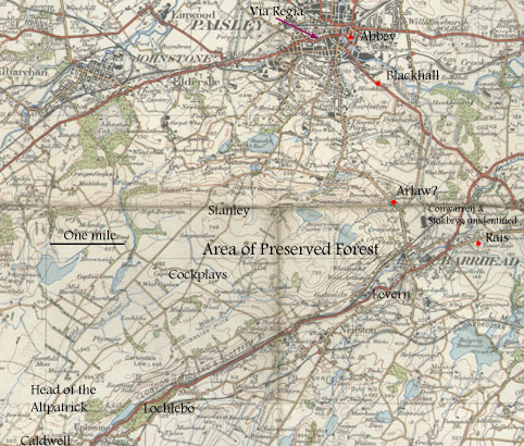
The boundaries of this preserved forest are given in
the charter: "as the Ruttanburn falls into the
Laverne, and ascending by the water of Laverne to the
Blackburn, and by the Blackburn ascending to a certain
ditch between Lochleboside and the Cockplays, and by
that ditch going up to the loch of Lochlebo, and by
the said loch westward to the marches of Caldwell, and
by the marches of Caldwell northward, ascending by a
certain ditch on the west of Carmelcolme between the
Langesawe and Dungelsmore, and from that ditch across
the moss to the head of the Altpatrick, and descending
that stream to the march of Stanely, descending between
Stanely and Cokplyss to the Ruttanburn, and so on by
the Ruttanburn descending to Laverne." (translation
from OPS)
To ensure that the preserved forest was as little disturbed
as possible, routes by which the monks and their men
had to pass were specified. These were: "the roads of
Arlaw, Conwarran, the Rass, Stokbryg, and the customary
tracks of the husbandmen." They were allowed to have
swords and bows, as well as dogs but had to unstring
the bows and have the dogs on leash when they passed
through the forest.
They could hunt and hawk on their own lands and fish
in the forest streams and in Kert-Paisley and Kert-Lochwinnoch
below the yare (weir) of Achendonnan but the Steward
retained the rights of birds of game.
Registrum de Passelet, pages
92-96
A
History of Paisley, 600-1908 (1909), William Musham
Metcalfe page 42
The
Abbey of Paisley from its Foundation to Its Dissolution,
J Cameron Lees, Paisley 1878, page 79
Origines Parochiales Scotiae, Vol
I, page 71
Interpretation
 At
first glance this charter seems very promising. However,
on closer reading it will be seen that although the
abbey had the right to move freely throughout part of
the forest (a term used to denote an area set aside
for hunting rather than a "forested area), the
routes are not specified. At
first glance this charter seems very promising. However,
on closer reading it will be seen that although the
abbey had the right to move freely throughout part of
the forest (a term used to denote an area set aside
for hunting rather than a "forested area), the
routes are not specified.
Nor is it easy to identify the named roads of Arlaw,
Conwarren, the Rass and Stokbryg. The Dictionary
of the Scots Language gives the meaning of warren
as a place reserved for the hunting of game or rabbits
and con as a squirrel but this does not help
identify the place. Stokbryg implies a crude wooden
bridge of stakes or poles (DSL) but again is of little
help. The Rass, however, was the hunting lodge of the
Stewarts and situated in present-day Barrhead (NMRS
record). Although the tower was built in the mid-1400's
we would have to assume that a hunting lodge in some
form existed here at the time of the charter. Arlaw
does not appear on early maps although there is a Harelaw
about a mile north of Barrhead on the Paisley road.
Blackhall is south-east of Paisley about one mile from
the abbey.
Based on this rather poor evidence one could surmise
that the approaches to the preserved forest skirted
the base of the Ferenze Hills and were in the general
area of Barrhead.
Paisley
In a charter of 1490 (relating to the foundation
of the burgh of Paisley) reference is made to "Beginning
at the end of the Bridge of Paisley, upon the water
of Kert, and extending by the King's highway towards
the west to the vennel opposite to the Welmedow, and
from thence equally ascending towards the north by the
dyke of the lands of Oxschawside to the wood of Oxschawe,
betwixt the said wood, as also the passage to the common
of the said burgh, and the broom dyke which extends
by the lands of Snawdon, from the common of the said
burgh to the water of Kert on the north, and the said
water of Kert............Further, we give and grant
to the said provost, bailies, burgesses, and community
of the said burgh, a common passage of the breadth of
twelve ells on the north side of Saint Ninian's Cross,
extending from the said part of the foresaid common
lands even to the other part thereof...."
Registrum de Passelet, page
265
The
Abbey of Paisley from its Foundation to Its Dissolution,
J Cameron Lees, Paisley 1878, page 155 ff
A
History of Paisley, 600-1908 (1909), William Musham
Metcalfe, page 100 ff
The History of Paisley from the Roman Period Down to
1884 (1886), Robert Brown - contains a map of Paisley
at the time of the charter.
Interpretation
All these places can be seen on the map included
in Brown's History of Paisley. All are in central Paisley
and the King's highway is now the High Street. A road
from Glasgow is shown on Blaeu in 1654 but not on Pont's
manuscript map of the 1590's although the road of the
charter could have been that coming from Glasgow.
Lochwinnoch
 The
bridge at Brigend (in Lochwinnoch) over the Calder is
said to have been mentioned in the Rental Book in 1525
(NMRS
record), although at the present day it is much
altered. The
bridge at Brigend (in Lochwinnoch) over the Calder is
said to have been mentioned in the Rental Book in 1525
(NMRS
record), although at the present day it is much
altered.
Interpretation
 Despite
its early existence (it is also shown on Pont's manuscript
map of the 1590's) it is not clear who built it and
for what purpose. It is certainly tempting to assume
it was built by the Abbey as they had the lands between
the Maich and the Calder but more definite evidence
would be needed. Pont shows another bridge downstream,
nearer to Lochwinnoch. An interesting question is if
Bridgend Bridge was connected with the route that must
have passed through here to Maich, one of the toll points
designated in the charter for Ayr. Despite
its early existence (it is also shown on Pont's manuscript
map of the 1590's) it is not clear who built it and
for what purpose. It is certainly tempting to assume
it was built by the Abbey as they had the lands between
the Maich and the Calder but more definite evidence
would be needed. Pont shows another bridge downstream,
nearer to Lochwinnoch. An interesting question is if
Bridgend Bridge was connected with the route that must
have passed through here to Maich, one of the toll points
designated in the charter for Ayr.
Kilbarchan
In 1177, a Henry of St Martin gave some land in
what is now Kilbarchan parish to Paisley Abbey. In the
charter there is mention of a road to a place called
Penuld. MacKenzie ( Kilbarchan: A Parish History, page
32) gives a translation which reads: "Beginning
at the Water of Grif and following the stream which
is called Lochoc as far as the rill which falls into
that stream, and along the said rill southwards between
two hills as far as the main road which goes to Penuld,
and from that main road in a straight line along the
side of the great rising ground called Bar-penald, towards
the site of a certain ancient chapel, as far as the
adjacent burn, and along it until it falls into the
Kert, and along the water of Kert until it meets the
water of Grif, and along the water of Grif as far as
the aforesaid river called Lochoc."
" Incipiendo scilicet ab aqua
de Grif et ascendendo per rivulum qui vocatur Lochoc
usque ad parvum torrentem qui cadit in rivulum eundem,
et sic per dictum torrentem versus austrum inter duos
colles usque ad magnam viam per quam itur apud Penuld,
et ab illa magna via in longum, per latus illius magni
collis qui vocatur Barpennald, prope situm cujusdam
antique capelle, usque ad torrentem propinquiorem qui
cadit in aquam Kert, et per aquam de Kert usque in aquam
de Grif, et per aquam de Grif usque ad predicte rivulum
de Lochoc."
Registrum de Passelet, page
48,49; see also Kilbarchan:
A Parish History, Robert Dunbar MacKenzie
Interpretation
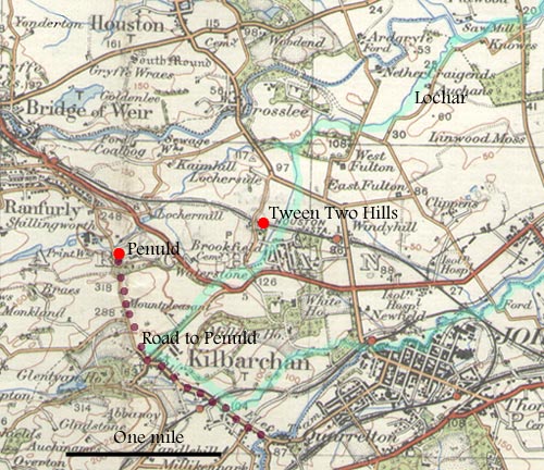 The
Lochar can be seen leaving the Gryfe near to Knowes
as can the rill running southwards just east of West
Fulton. This is where the two hills are and MacKenzie
has the interesting observation that the placename here
of "Tween the Hills" (also Tween Two Hills)
may be a direct reference to the "inter duos colles"
of the charter (MacKenzie, page 250). Bar-penuld can
only be Barr Hill just east of Kilbarchan - the burn
referred to can be seen south of Barr Hill where it
joins the Cart. The
Lochar can be seen leaving the Gryfe near to Knowes
as can the rill running southwards just east of West
Fulton. This is where the two hills are and MacKenzie
has the interesting observation that the placename here
of "Tween the Hills" (also Tween Two Hills)
may be a direct reference to the "inter duos colles"
of the charter (MacKenzie, page 250). Bar-penuld can
only be Barr Hill just east of Kilbarchan - the burn
referred to can be seen south of Barr Hill where it
joins the Cart.
Penuld was about one mile north of present day Kilbarchan
near the Lochar water. The context in which the road
is mentioned indicates that it must have had much the
line (if not the same) as the present day road running
through Kilbarchan towards Bridge of Weir.
Strictly speaking the charter reference is only to
a couple of miles of road from just south-east of Kilbarchan
to Penult (present-day Penwold) but it is certainly
possible that on the south-east stretch it crossed the
Cart and went towards Paisley. In the other direction
Penult, where there was an early castle, may have been
the destination especially as the charter refers to
it as the road to Penult and not beyond into Strathgryfe.
Mearns
A charter dating from c.1273 which mentions two
roads will be dealt with at a later date.
Registrum de Passelet, page
102
Origines Parochiales Scotiae. Vol I, Mearns,
page 97
Outwith Renfrewshire
As said, the Abbey had numerous possessions in what
is now Renfrewshire (see Rental Book in J Cameron Lee's
history of the abbey) and many tenants were required
to cart produce to the abbey. There were granges at
Blackstone, two miles north-west of the abbey, at Kilpatrick
and at Monkton. Hall notes a grange at Auchengrange
near Beith (Derek Hall, Scottish Monastic Landscapes,
page 134). Other lands included:
Linbren
This was a fishery on the River Leven at Bonhill. The
charter refers to a via regia coming from Dumbarton
- see Dunbartonshire
Glasgow
About this time (1321) Abbot Roger bought a tenement
in Glasgow in "the street which is called the Rattonrow,
between the land of Sir Maurice Starine, chaplain, on
the west, and the King's highway which is called le
Weynde on the east."
The
Abbey of Paisley from its Foundation to Its Dissolution,
J Cameron Lees, Paisley 1878, page 94
Registrum de Passelet, pps
385, 387
Faifley etc
There were holdings in Faifley, Duntocher, Cochno, Edinbarnet
etc north of the River Clyde which would have entailed
numerous journeys to and from the abbey, including having
to cross the Clyde.
Ayrshire
There were also holdings in Ayrshire in Monkton and
Prestwick and Dalmilling, prior to those lands being
passed to Crossraguel Abbey.
Top
|

