Overview
The
Romans invaded Scotland three times. The first invasion
was by Agricola in 78 AD and the occupation lasted until
the end of the century when there was a withdrawal to
the Tyne - Solway line. This was followed by the Antonine
invasion in 142 AD when the Antonine Wall was built.
The occupation lasted sometime into the 160’s when there
was a withdrawal to Hadrian’s Wall though a presence
was maintained in the south of the country. There were
two further campaigns by Severus between 208 and 211
AD.
The
majority of the roads appear to date from the first
invasion. A main road (Dere Street) ran from Corbridge
across the Cheviots to Newstead and the Forth near Edinburgh
and then probably over towards Falkirk and up towards
Stirling. Another main road (Watling Street) ran from
Carlisle north to Crawford, continuing on the east side
of the Pentlands to the Edinburgh area. An east-west
route crossed this near Biggar which may have run from
Newstead to Barochan, with an extension to Loudoun Hill.
A loop road ran from the westernmost road near present
day Lockerbie over to Nithsdale and then northwards
to rejoin the main road near Crawford. From the Falkirk
area, a road has been traced someway beyond Perth connecting
the forts sited at the mouths of the glens.
In
the Antonine period it is thought a road was built to
link the east and west roads through Raeburnfoot, as
well as the military road running to the rear of the
Antonine Wall.
A
great deal of work has been done to determine what other
roads there might have been and also to fill in obvious
gaps between known stretches of road. For example, in
the south-west, a road is posited to Glenlochar and
Gatehouse of Fleet and perhaps beyond; as well as roads
running up the Cree, Ken and Nith valleys into Ayrshire.
The road to the Loudoun Hill fort may have continued
to the Ayrshire coast and it is thought roads may have
ran from Castledykes to Crawford and up past Castle
Greg.
There
are also many references in the antiquarian literature
to traditions of Roman roads in a locality. While we
will deal with these in detail it is interesting to
note some of these. A road had been thought to run from
Berwick up the east coast towards Inveresk; another
from Jedburgh to Roxburgh; and one from Carlisle to
Hawick and onwards to Newstead. In Lanarkshire there
was supposed to be one from Carluke up to the Antonine
Wall and one on the north side of the Pentlands to Castle
Greg. North of the Antonine Wall, one was conjectured
to run north from Braemar to Forres and another through
Aberdeenshire to the counties of Banff and Elgin. Most
of these are not accepted as Roman.
The
Known Network
Dere
Street
See here for
some useful references. There are also many references
to Roman roads in Discovery
and Excavation in Scotland and on Canmore.
See also Roman Roads in
Ayrshire.
Roman
roads mentioned in antiquarian literature
This
section gives some details of roads proposed by various
antiquaries and cartographers. Some of these exist but
have been misidentified as Roman while others are quite
speculative, i.e. no road exists but a conjecture has
been made that a Roman road must have followed a certain
route. Despite their generally speculative nature, some
may repay further examination.
East
of Dere Street
There are a couple of references in antiquarian
literature to roads in this area although these have
not been supported by any evidence. This lack of roads
as well as of attested forts supports the view that
the Votadini, whose territory this was, were on friendly
terms with the Romans and so were never occupied. Despite
this, it is still conceivable that there were roads
and forts or marching camps, even if not for military
use, and it is best if the evidence for these (which
is not particularly convincing) is considered on its
own merits.
The one Roman road in the area that is accepted as such
is the Devil's Causeway running through Northumberland
to Berwick on Tweed, perhaps to service a harbour there.
 |
| Based on quarter-inch OS maps,
1922, 1923. With thanks to Ordnance Survey. |
East
Coast Road William Maitland in his History and Antiquities
of Scotland (vol.1, p.202-3) refers to an east coast
road from Berwick via Coldingham Moor to Old Cambus
(for which he gives an unlikely derivation from "old
camp") and then Dunbar where there was a tradition
of a Roman camp. From there it went to Camp-hill, a
mile and a half NE of Haddington, and then on to Musselburgh
where there were faint appearances to the west of the
town. Its course then went by Leith, presumably to Cramond.
Modern
research has not confirmed any Roman remains near Old
Cambus (see for example A
history of Coldingham priory, Alexander Allan Carr,
page 14 that mentions these), nor at Dunbar or Haddington
(Canmore
entry for Camp-hill) which make a road very unlikely.
However, the reference to Musselburgh would fit a road
starting at and heading west from Inveresk which is
close to Musselburgh, Inveresk itself being reached
from the south rather than a coastal route.
Road to St Abb's Head
William Roy in his Antiquities of the Romans in North
Britain notes the Roman road called the Devil's Causeway
running from Watling Street (later known as Dere Street)
at Bewclay up to the Tweed near West Ord from where
it pointed towards Mordington. However, he says that
no traces of any continuation had been found in Berwickshire.
 |
| The
straightness of the old Edinburgh to London road
across Coldingham Moor is suggestive of a Roman
road but confirmation of this has not been found. |
The
Devil's Causeway is also shown by Ainslie in his 1789
map of Scotland but crosses over the Tweed a little
to the east of where Roy placed his crossing and continues
through Ayton and Coldingham to a Roman camp at St Abb's
Head.
The
New Statistical Account refers to a Roman camp at St
Abbs, on a hill west of the Head. From Chalmers' description
of the various camps in the area the one in question
was situated just north of Millar's Moss Reservoir and
is now classed as a settlement (Canmore
record).
Robert
Stuart in Caledonia
Romana, page 264 says that St Abb's Head was probably
a naval station connected to Hadrians Wall by a road
and notes some occurences of the placename Chesters
in Ayton parish that may indicate camps along this road
though no traces of these or a road can be seen.
Crachoctrestrete
 |
| Places mentioned in the charters.
Parish boundary shown in green. Based on half-inch
OS map, sheet 28, 1914. With thanks to Ordnance
Survey. |
This
road is mentioned in mediaeval charters relating to
the boundaries of Coldinghamshire, viz."from the boundary
between Berewic and Lambertun, as far as Billie, thence
to Drieforde, thence to Middlesdenehead, and from that
by Mereburne to Crachoctrestreet, thence to Eiforde,
and from that to the rivulet which flows into the sea
at Auldchambuspethe." (Adam
Thomson, Coldingham: Parish and Priory, 1908, p. 4).
J Hewat Craw lists the various charters, one of which
by Alexander II is worded "from midlesdeneheued
by mereburnesheued to the west as far as Crachoctrestrete,
thence by the same road as far as Eiford." A sasine
from 1647 says "and while ye come to the Crawbockchaster-street,
and thence be the same street to Ifuird..." These
references indicate that the road went at least as far
as a ford over the Eye. (Crachoctrestrete:
A Forgotten Berwickshire Road, J Hewet Craw, Berwickshire
Naturalists Club, Vol.27, Part 1, (1929), pps 93-95).
 |
| Although not on
the parish boundary, this track continues the line
of Crachoctrestrete as least as far as Ecclaw. Looking
south from minor road 600m SW of Butterdean. Fawcett
Wood on skyline. |
Thomson
suggests Drieforde may have been a causeway across Billie
Mire though Craw thinks it more likely to be north of
Billie as it is mentioned after Billie in the charters.
Middlesdenehead would have been near Mayfield and Mere
Burne would be Mire Burn (he may be referring to the
Drakemire area north of the previous location though
which of the two or three burns hereabouts is the Mere
Burn is not clear). He notes two locations posited for
Crachoctre: Prestoncleuch and near the parish boundary
west of Warlawbank. Craw favours Warlawbank, suggesting
Crachoctre is a corruption of Crawchester, noting the
Auchencrow in the locality and the fort at Wardlawbank.
He has a photograph of a holloway at the east end of
Fawcett Wood and running along by the parish boundary
towards the ridge of high ground where the fort is sited.
Both Thomson and Craw have Eiforde as a ford across
the Eye, on the old road to Butterdean - a ford is shown
on the 6"map on the line of the parish boundary
about 1 kilometre south of Butterdean. It is not clear
if the boundary continued along the line of the old
road that runs NNE to Ecclaw where the Heriot Water
could be the rivulet running past Auldcambuspath or
if it went more directly to the vicinity of Auld Cambus.
At
its northern end, C A-Kelly (Canmore record NT76SE
35) examined the line from Billiesmire to Ecclaw
which is clearly shown by the boundary between Bunkle
& Preston and Coldingham parishes, field boundaries,
and tracks. Traces of a ploughed-out mound, and flagging
were found. It may have originally gone from Ecclaw
to Oldhamstocks.
South
of Billiesmire, the line is uncertain. One could speculate
that if Roman it could have come from East or West Ord,
or Berwick itself, i.e. an extension of the Devil's
Causeway or from a putative Roman camp south of Chirnside
but these would be very speculative. The Session
Book of Bunkle and Preston (p.xxxvii) says that
the Billie Burn was an extensive mire and was crossed
by causeways - this was the origin of nearby Causewayend
thought by some to be Roman (note: The OSA for Chirnside
also mentions causeways crossing the Billie Burn but
these are some distance from Causewayend).
Clearly,
however, the road is very old, and possibly Roman. Four
derivations of the name have been given. Barrow in Charters
of King David I, page 74 suggests "Roman road
by the oak tree frequented by crows (OE craca, crow)".
Adam Thomson in Coldingham:
Parish and Priory, 1908, page 4 tentatively suggests
"the cross by the oak tree." Alan James has 'Upper-farm
Crag' (Brittonic Language in the Old North database)
and Craw, while not giving a meaning, refers to the
link with a fort or camp through the word "chester".
All these derivations indicate the age of the road.
Chirnside
As noted above, a Roman camp and possible road had
been suggested for a site south of Chirnside. In the
OSA for Chirnside (Vol.14,
page 32), the writer describes what he thinks could
be a Roman fort sited near Stuartslaw farm beside the
Whiteadder.
He
argues that if, as Tacitus says, the main invasion route
was along the coast with support from the navy, this
fort could have served to guard Agricola's flank. The
argument is not as strong as it seems as this coastal
advance is now thought to have taken place much further
north, however, Agricola could still have advanced near
the coast and may have had outposts guarding his flanks.
The
Canmore entry (NT85NE
8) notes the tradition that this was Roman although
one comment does not think the remains are Roman - hardly
anything can now be seen at the site.
Fogo
Parish
The
New Statistical Account for Fogo says:
"Antiquities.—The only vestige of antiquity in
the parish is an old Roman camp at Chesters, in the
west end of the parish; the stones of which have been
mostly removed to make way for the plough. The situation
shows how careful the Romans were of the health of their
armies,—the soil being light and dry, - and the situation
being near water, and by its elevation, commanding an
extensive view of the surrounding country. There was
lately trenched up what appeared to have been a Roman
causeway, passing through a marsh adjoining this parish
on the south, and probably leading to this camp."
(page
225).
The
Canmore entry for this site (NT74NW
7) assesses it to be a mediaeval fort.
Between
Dere Street and Watling Street
Jedburgh to Roxburgh
Stobie's map
of Roxburghshire refers to vestiges of a road that ran
from Roxburgh to Jedburgh and then to the Eildon Hills
although the road was not shown on the map and the wording
does not indicate its route. Jeffrey (The History and
Antiquities of Roxburghshire and Adjacent Districts
vol.1,
p.253) suggests it crossed the Teviot at Bonjedburgh
and in fact Roy notes the reference in Stobie and thinks
it a possibility, given its situation, that Roxburgh
could have been a Roman station. He shows it as a direct
line on his map with pecked lines indicating it was
not completed or perhaps conjectural.
Carlisle
to Hawick (Tarras Water)
The
line of this supposed road is shown very clearly on
Ainslie's maps of 1789
and 1821.
The road is mentioned by Roy on page
105 of Military Antiquities where he notes a road
leaves the
 Annandale
road at Longtown and heads northwards towards Canonby.
From Liddell Moat he suggests it led into the valley
of the Tarras and from its direction no doubt headed
for Hawick from where it could have gone either to Bonjedburgh
or the Eildons. This would have given a link between
Carlisle and the Lothians although he notes that it
may not have been completed, perhaps because of shortage
of time or because the Annandale road was adequate for
this purpose. His map shows it running to Melrose and
he mentions the author of the history of Melros (Milne)
having said that there was a great military way running
south from the Eildons. However Milne talks of Halidon
Park and not Midlern Park as Roy does, so that the "road"
is likely to be the earthwork raised by David I to mark
the boundary between lands given to Melrose and Kelso
abbeys (see The History and Antiquities of Roxburghshire
and Adjacent Districts, Alexander Jeffrey, volume
iv, page 51) Annandale
road at Longtown and heads northwards towards Canonby.
From Liddell Moat he suggests it led into the valley
of the Tarras and from its direction no doubt headed
for Hawick from where it could have gone either to Bonjedburgh
or the Eildons. This would have given a link between
Carlisle and the Lothians although he notes that it
may not have been completed, perhaps because of shortage
of time or because the Annandale road was adequate for
this purpose. His map shows it running to Melrose and
he mentions the author of the history of Melros (Milne)
having said that there was a great military way running
south from the Eildons. However Milne talks of Halidon
Park and not Midlern Park as Roy does, so that the "road"
is likely to be the earthwork raised by David I to mark
the boundary between lands given to Melrose and Kelso
abbeys (see The History and Antiquities of Roxburghshire
and Adjacent Districts, Alexander Jeffrey, volume
iv, page 51)
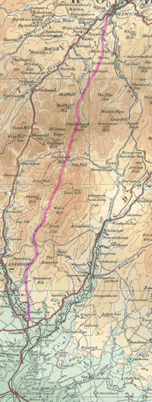
Continuation - Hawick to Newstead

| Based on quarter-inch OS map,
1922. With thanks to Ordnance Survey. |
Eskdalemuir
 |
| Near Over Cassey |
OSA,
vol.12, p.614
The OSA refers to a Roman road from Netherby to near
Langholm and notes reports that it may have been discovered
near Over-Causeway (now Over Cassey) at the head of
the parish (Eskdalemuir).
The
Ayrshire Road
and Nithsdale to Ayr
 Older
OS maps show a Roman road running south from Ayr to just
beyond Dalmellington. It then continues as a "Pack Road"
towards Carsphairn and Dalry.
Older
OS maps show a Roman road running south from Ayr to just
beyond Dalmellington. It then continues as a "Pack Road"
towards Carsphairn and Dalry.
Chalmers,
however, notes a tradition that south of Dalmellington
the Roman road ran eastwards over to Nithsdale.
These
notes (see link) look at the various courses that have
been proposed for the road and assess the likelihood that
there was a Roman road from Nithsdale up to Ayr.
| Based on half-inch OS map, sheet
31, 1914. With thanks to Ordnance Survey. |
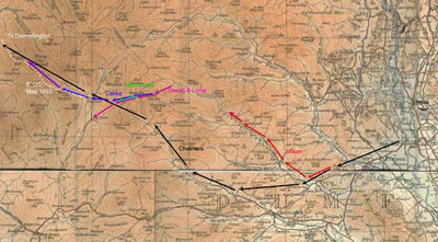
Dumfriesshire
outlier via Daer Water - Ainslie's maps
 |
| The road is supposed to have
ran across this landscape (from the right or south-east)
and then up the valley on the left towards the Daer
Water |
 |
| Based on quarter-inch OS map,
1922. With thanks to Ordnance Survey. |
The
road is
shown on Ainslie's map
of
southern Scotland printed in 1821. The main
Annandale
road, while it has the general line of the actual road,
is incorrect by a mile or so, and even more so beyond
Moffat though it heads for the camp at Little Clyde
as does the actual road.The
more westerly road has an odd course, unsupported in
the literature, that takes it up to the Daer Water.
For some reason, both the roads terminate at a sheet
edge but it is reasonable to assume they would both
have continued to Crawford.
His
earlier map of 1789 is more accurate in the sense that
it runs across to the Nith near Thornhill then by the
Wall Path to Crawford. Nevertheless the map is so imprecise
and deviates so much from work that has been done to
determine the route actually taken that we can be confident
that it just sketches in a rough course for an actual
road.
 |
| The Well Path - looking towards
the Roman fortlet and road north of Durisdeer |
Roy
shows the road on his map which is too small a scale
to be accurate. However, his description of it is more
accurate taking it from Dryfesdale church, Wood Castle,
Murder Loch, Lanegate and Duncow to Dalswinton where
there was a fort. It then went past Thornhill and by
the Well Path to Crawford.
Top
Further
roads will be added in due course
|
 With
so much written about Roman roads, this section will
just provide brief notes on the known network and on
missing sections of road within that network, along
with
relevant links and references.
With
so much written about Roman roads, this section will
just provide brief notes on the known network and on
missing sections of road within that network, along
with
relevant links and references. 
