|
OVERVIEW
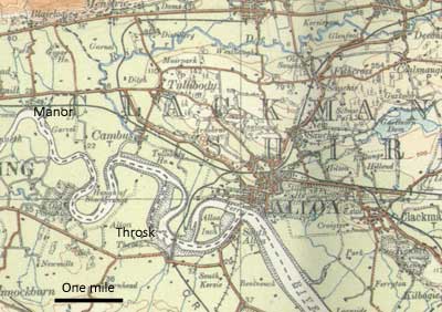
There are traditions of Roman crossings at Manor and
Throsk, with traces of a causeway and castellum at Manor.
The crossing at Throsk may have been the Pons Servani
across which St Kentigern is said to have fled to escape
enemies. At any rate there are large spreads of stones
at Throsk which served to create a (dangerous) fording
point and may have given rise to the tradition of a
bridge.
At a later date (1559), a bridge at Tullibody was thrown
down to delay a party of Franch troops but they tore
down the roof of the church to ford the river. When
a bridge was built at Dollar some people contined to
cross the river on stilts.
The River Forth was navigable to Stirling, and Alloa
was a port that had considerable trade with coastal
towns and the continent. There were regular steamboat
services to Edinburgh and Stirling. Coal was brought
down to the harbour along horse-drawn railroads and
a waggon-road was made on top of an embankment at Clackmannan.
Canals had been planned for the area but never got off
the ground.
There are the usual remarks about statute labour and
turnpike roads and the general improvement in transport
by the time of the NSA.
ALLOA
 OSA OSA
It seems probable that the Romans crossed the Forth
either near Manor,
some 6 miles upriver from Alloa, or at the ford of the
Frosk, one and a half miles distant. There are traces
of a causeway at Manor and till recently, the remains
of a small castellum which may have protected the passage.
Mention of the ferry
with piers on either side of the river. It has been
called the Craig Ward and sometimes the King‘s
Ferry. If turnpike roads are made on either side of
the Forth, this would be an ideal crossing place for
journeys north and south. West of the ferry there is
a glass manufactory, to which coal is transported by
waggon-way.
Mention of a French force in 1559 when the bridge of
Tullibody was broken down to delay their
movements - the church was unroofed and the materials
laid down on the bridge to allow a crossing
of the river.
The author recounts a story about James V being hospitably
entertained in a cottage, the hosts not
knowing who their guest was; the cottager was awarded
the title of King of the Muirs and told that
the next time the king was in Stirling he should present
himself there and ask for the Goodman of
Ballinguiach, a title the King used when in Stirling
- this was a steep path on the north west side of the
castle rock.
A description is given of the carts
that were used in the past - they were little larger
than a wheelbarrow
and consisted of an axle on which rough boards were
placed; wheels were just pieces of wood joined
together. Present carts are much superior.
Markets: There are 4 annual fairs and 2 weekly
markets.
Port: There is an important port in Alloa which
includes not only the town but various creeks along
the
river Forth between Kincardine and Stirling. There is
considerable trade through the port - coal and glass
bottles being major exports.
Post
Office: There has now been a post office for
some 30 years; before that a runner went to and from
Stirling.
Roads: The statute labour system is directed
by the Justices of the Peace. Labour has been commuted
for
a monetary payment and, to an extent, the requirement
for farmers to provide carts. Plans for turnpike roads
have been proposed. Perhaps because of this, the statute
labour system is not always implemented fully.
The roads have also suffered because of the “many
heavy cartiages while the distilleries were flourishing.”
NSA
 |
| The River Forth at Alloa - the
old ferry terminal is directly opposite in the centre
of photo |
One derivation given for the name is aull waeg meaning
the way to the sea, or the sea-way.
There is a ferry at Alloa. Vessels can navigate beyond
Stirling to the "Cruives" of Craigforth and
boats up to 800 tons can reach Alloa.
At the Rhind point (about 2 miles SW of Alloa town centre)
there is a ford called Throsk Ford. There is a
great spread of boulders here as far as the low-water
mark and the ford is four feet higher than low-water
at
Alloa downstream; upriver there is deeper water. It
is considered to be a Roman ford, like others upstream
towards Stirling.
A horse-drawn railroad runs from the coal pits to the
harbour - it was formed in 1766. Formerly a horse
could draw only 6 cwt of coal, now it can pull 8 tons.
Full details are given of the successive improvements
to the railroad.
Details are given of the considerable trade carried
out through Alloa both with the continent and along
the coast.
Parochial Economy: The main town is Alloa which
has two weekly markets. The streets are well paved and
clean except in the old town.
Means of Communication: Each day steam-packets
sail to Stirling, Edinburgh and other towns on the Firth.
A coach runs daily to Glasgow through Falkirk, and one
to Stirling, for the canal boats from Glasgow.
Carriers run to Glasgow, Edinburgh and all the local
towns.
Twelve miles of turnpike, and the bridges are good.
The writer mentions the incident of the French forces
unroofing the church to use the materials to bridge
the stream.
Fairs: One major fair in August is very well
attended from the surrounding district; there are three
lesser
fairs throughout the year.
Inns: There are 5 hotels and inns and in 4 of
these chaises and other carriages can be hired. In all
there are
72 places in the parish where drink can be obtained.
Fuel: Coal is available locally at low cost.
1840
 |
| The River Forth at Rhind Point
- changes since the 1860's have been considerable.
Image from Google Earth. © 2009 Tele Atlas.
Image © 2009 Getmapping plc |
Note: Old maps, particularly the 6”
and 25” maps of 1860, show firstly, a large spread
of boulders directly
opposite Rhind Point at the site of a partly-demolished
railway bridge. Secondly, they show a spit of gravel
just upstream, near to Throsk Farm which reaches to
within 120 feet of the north bank. It is not clear which
of these the writers were referring to, although their
wording suggests there was a ford at one or the other.
In
his Report as to Improving the Navigation of the Rivers
Forth,etc, Alexander M’Gibbon, writing in 1810
refers to “A rumbling ford of large stones, called
the Throsk Ford, very dangerous.”
Jocelyn, a monk of Furness Abbey in Lancashire, wrote
a Life of Kentigern, circa 1185. In this there is an
account of how Kentigern fleeing from rivals, crossed
a river by a bridge known as Pons Servani. There is
a possibility that the above mentioned spit or the boulder
bed is where this happened - see Cynthia
Whidden Green, The Life of Kentigern, chapter VIII,
footnotes 73,78,79 and also Kenneth H Jackson's paper,
The
Sources for the Life of St Kentigern (pages 307-309)
in Studies in the Early British Church. He notes that
the river is not fordable nowadays and refers to a remark
by Angus Graham that “ford” is used locally
for formations like these, whether they are fordable
or not.
While the remark that there was a Roman ford here is
interesting, it would be very difficult to confirm.
The course of the river, as shown in such maps as we
have, has changed significantly even in the last 200
years or so, and from the remark about Ferrytown under
Clackmannan parish may have been much wider in the past.
What it was like in Roman times is very difficult to
say. In addition, the boulder spread and the spit are
more likely to be natural formations rather than man-made.
There may, however, be some truth in the Kentigern reference
given the geographical context of the tale and discounting
the more legendary aspects although it is interesting
that the NSA refers to a double tide in the area which
could be consistent with the account. If there actually
was a bridge linked to a ford this would make the crossing
of the river much more feasible, though it could hardly
be proved today.
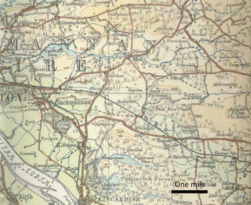
CLACKMANNAN
 OSA OSA
Although in picturesque countryside, the village with
its many wretched and mean houses is not. The tollbooth
and court-house are a heap of ruins.
There are 3 bakers and 8 grocers in the village, along
with a dozen or so tippling-houses, to the detriment
of morals. There are two fairs, the one in September
being important with black cattle and horses for sale
along with linen and cloth and all sorts of other goods.
In the past much wool was sold at this market but very
little in recent years.
It seems likely that the river was once much wider,
as witness the village called Ferrytown which is now
5 furlongs from the river.
When an embankment was built for a major reclamation
scheme, a waggon-road was formed on top of it to allow
coal to be brought to boats that were too large for
the usual loading-place at the Pow of Clackmannan
 |
| Town centre Clackmannan.
The "clog" or "stone" of Manau,
a Celtic sea-god, is resting on top of a huge pillar
seen to the left of the tollbooth. Originally the
stone was nearer to the Forth, which itself was
wider in early times. |
There are collieries at Clackmannan, Sauchy, and Kennet.
Some 7000 tons are exported each year to Leith, Dunbar,
Perth, Dundee, Montrose, and other places. The coal
reaches the harbour in waggons of a ton and a half from
the pits about three quarters of a mile away.
Considerable details are given of the distilling trade
carried on in the town and also of the iron works.
In the town there are 10 carters and 2 cadgers. There
are 192 carts in the parish, a coach and 2 chaises.
There used to be a ferry over the Forth, opposite the
village of Clackmannan. A ferry would still be of great
use to those on both sides of the river and it would
be quite easy to construct a safe landing place at the
harbour at Clackmannan Pow. If a village were to be
built there it would be in a good position for conducting
trade.
Both the county and this parish have suffered for many
years from the bad condition of the roads. It is hoped
that this will change with the passing of the turnpike
road bill presently before Parliament
NSA
Details are given of the Devon Iron Works and the railways
which serve the works.
Parochial Economy: Clackmannan is the only town
in the parish. Two markets are held each year but not
much business is transacted there. Although there are
plenty of shops, those in Alloa are superior and many
people prefer to go there.
The town has a post-office, with posts from North Queensferry
to Alloa and Stirling and from Stirling and Alloa to
North Queensferry each day. There is a daily coach to
and from Alloa to Glasgow, which passes through Clackmannan.
Steam-boats sail between Stirling and Granton pier near
Edinburgh, and pick up passengers at Alloa and Kincardine.
Coal is available locally at a reasonable cost.
November 1841
DOLLAR
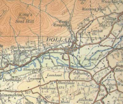 OSA OSA
A fine bridge
over the Devon, near the church, was destroyed by a
flood some years ago. There are plans to have a wooden
bridge erected, mostly by the generosity of a few public-spirited
persons, which will be of great benefit to those going
to church. The lack of a bridge would have not have
been so serious 20 or 30 years ago, as at that time
“people in this place were very expert in crossing
the river on stilts. And there are still some who cross
it in this way.”
Coal from here and Blairingone is carried over the Ochils
to Strathern.
Roads: Two highways pass through here, between
Stirling and Kinross. The road on the south side of
the Devon has not been gravelled and is almost impassable
in winter; the road on the north side, near to the Ochils
has a better natural foundation and hence is more frequented.
Dollar is the natural stage or stopping place on this
road but the road is very narrow and coaches can just
pass.
The road is very busy with travellers to Kinross, as
well as Perth, Dundee and other places.
NSA
Mention of roads between Dollar and Alloa and Blairingone
to Alloa.
A canal had been proposed to run from Dollar to Cambus
on the Forth but the proposal came to nothing.
There is an old bridge in Dollar.
Parochial Economy: The nearest market-town is
Alloa, seven miles from Dollar. A mail runner goes between
Alloa and Muckhart each day.
The Kinross to Stirling turnpike and the Dunfermline
turnpike pass through the parish.
A stage-coach service from Glasgow to Perth through
Dollar no longer runs because of lack of patronage.
A wooden bridge over the Devon at the Rack-mill is in
“a very ruinous state, and often impassable“
This makes it difficult for those on the south side
of the Devon to get to church, and for children to reach
their school.
Fairs: There are four fairs, two of them considerable.
Inns: There are about 12 places where drink can
be obtained, including the house at the toll-bar.
Fuel: Coal is available locally at a reasonable
price.
TILLICOULTRY
 OSA OSA
Gate
Mail: This is a tax paid to the family of Mar
for the right to use a private road through the estate
to the Pow of Alloa. While the road is kept in good
repair there should really be a public road from Tillicoultry
to what is a public harbour and a market town.
Roads: The roads along the foot of the hills
are reasonably good as is the road that goes from Coalsnaughton
by the bridge. However, the south road has been much
neglected and is in very poor condition. Part of it
to the east of Coalsnaughton was never properly made.
Amongst various suggestions for improving the parish,
the author lists “a waggon-way for carrying the
coals to Alloa harbour.” (at the time there was
also much talk of having a canal in the area).
 |
| Ochil Hills at Tillicoultry |
NSA
Market-Town: Alloa is the nearest market-town,
four miles away, and it is nine miles to Stirling. The
parish, however, is well supplied with the usual necessaries.
There is a post-office, and a daily post between Alloa
and Muckart.
There are good main roads to Alloa, Stirling, and Kinross,
with plenty of excellent materials available locally for
repairs. The bridge over the Devon was widened about 20
years ago. There is a wooden bridge below Tillicoultry
for foot-passengers.
Inns and Public-Houses: “There are ten public-houses
in the parish ; and there is no doubt that our Saturday
evenings would be more quiet and our Sabbaths more solemn,
were fewer opportunities afforded the thoughtless and
the dissipated of injuring their health and morals, and
exposing themselves to all the evils which drunkenness
entails.”
Fuel: Coal is easily obtained locally.
Top
|

 The OSA references below are to the Edina site and mostly
to the main entry on roads for each parish with some
additional links provided to other relevant information.
When Edina page appears go to browse scanned pages for
the link.
The OSA references below are to the Edina site and mostly
to the main entry on roads for each parish with some
additional links provided to other relevant information.
When Edina page appears go to browse scanned pages for
the link.

