Overview
Pont Texts
River Crossings
Placenames
Overview
Of the river crossings the bridge at Bonjedburgh
would have facilitated access to Jedburgh from north
of the Teviot. The purpose of the crossing at what is
now Galashiels is not so clear, perhaps on routes to
Lauder and Peebles. Placenames related to bridges are
clearer. Thus there was an old wooden bridge at Bridgend
near Melrose that was probably on a route from Lauder,
Dalkeith and Edinburgh down to Selkirk. Brighauch was
associated with the Minchmoor route that gave access
to Peebles and Clydesdale, and the bridge at Kelso would
have allowed access to Berwick from Hawick and Jedburgh.
Of the remaining names Hexpetth (not shown on Lauderdale
map) is suggestive of a long distance route, perhaps
branching off the main Edinburgh to Kelso road at Lauder.
Langatt also may indicate a route from Lauder up to
the Lothians though its ultimate destination is unclear.
The function of the ford and road indicated by Craikkesfoorde
and Rippeth is not clear but the abbeys did have lands
in the Leader valley. Rutherford and Eckford (not shown
on Lauderdale map) probably relate to local routes.
A number of spittal names are included as they sometimes
catered for pilgrims and travellers but unless there
is evidence that this was their function they should
be used with caution as they could be for example an
almshouse, a leper hospital or straighforward hospital
with no relevance to routes.
Texts written by or derived from Pont indicate routes
from Berwick to Kelso, Kelso to Jedburgh, Jedburgh to
Hawick, Jedburgh to Selkirk and Selkirk to Edinburgh.
Click for larger
map
Note: Hexpath, Sisterpath, Smailholm
and Ednam Spittels and Eckford are not shown on the
Lauderdale map.
| River Crossings |
|
Placenames |
|

Map Based on quarter-inch OS maps, published 1935 &
1945.
With thanks to Ordnance Survey.
Pont Texts
A number of texts written by or derived from Pont give
distances between towns. It is very likely that these
relate to routes because the distances must have been
measured and there would be little point in knowing
the mileage unless people were travelling between these
places. In some cases he refers directly to "the
way to" or gives a list of intermediate places
as if they were on a route. The river crossings he shows
must have been used for journeys. There is in any case
evidence from other sources that there were routes at
this time. The texts can be viewed on the NLS Pont
Website and are also in MacFarlane's Geographical
Collections.
So far as this map goes, the following entries indicate
routes through this area:
- Berwik Kelso 20 Later maps
show this running though Coldstream;
- Haick Jedburg 8 From later
maps this probably went directly over to Denholm from
Jedburgh and then directly to Hawick;
- Jedburg Selkirk 8 This would
have used the crossing near Bonjedburgh - see immediately
below;
- Jedburg Kelso 7 Later maps
suggest the route went by a still existing track over
to Crailing and then followed the line of the present
day road through Eckford to Kelso;
- Selkirk Edinburgh 22 m (see
NLS)
The early route seems to have used the bridge at Caddon
Foot and then went up by Clovenfords.
River Crossings
At Bonjedburgh
Identification
Bridge over Teviot at present day Bridgend, 1 mile SE
of Ancrum, NT639 237
Associated route
MacFarlane (Geographical Collections, Vol.2; also see
immediately above) shows distances between Jedburgh
and Selkirk and Jedburgh and Kelso which imply routes
existed in 1646 when this list of distances was made
up. Melrose is not mentioned. MacKenzie in Lilliesleaf
and Its Old Roads (Transactions of the Hawick Archaelogical
Society, 1947) gives an interesting account of the two
mediaeval Selkirk to Jedburgh routes, both of which
would have used this crossing. The bridge is mentioned
in 1547.
* also shown on Teviotdale map
At Galasheels,
on river south of Gala Water
Identification
Crossing stream in Galashiels, NT 490 360
Associated route
The orientation of this stream favours a route on a
NW-SE line but it is difficult to say what any through
route might have been, perhaps Selkirk to Dalkeith if
the Tweed was crossed at Boldside as suggested by the
Military
Survey map. The town of Galashiels did not exist
at the time.
*also shown on Teviotdale and Tweeddale maps
Placenames
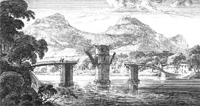
Bridgend,
Kelso
Identification
At south end of present day bridge over the Tweed.
NT 727 337. No bridge is shown on the map but this may
be because the bridge was broken down by the local people
as a defensive measure during Hertford’s campaign of
1547. The bridge was of stone and erected in 1330. (Image
of ferry in the 1680's from Slezer's Theatrum Scotiae
- NLS site)
Associated route
Although the bridge would have facilitated movement
between Roxburgh and Kelso, its function was probably
more related to a route to Edinburgh by Smailholm and
Legerwood (The
Roads that led to Edinburgh etc, Harry R G Inglis, PSAS,
Vol. 50, (1915-16), p. 40) and would also have given
access to Coldstream, Berwick, Jeburgh and Hawick.
* also shown on Teviotdale map
Brigheuch
Identification
Near Bridgelands, 1˝ miles NNE of Selkirk, NT 481
304. Kelso Abbey had land on both sides of the River
Ettrick, with pasture rights on part of Minchmoor, granted
them by Alexander II. A condition of the grant was that
they maintain the bridge existing at the Ettrick.
Associated route
There is undoubtedly a connection with the Minchmoor
route both because of the pasture rights and the references
to Minchmoor in Kelso charters relating to Lesmahagow.
That said, it is not completely clear where the route
was. Inglis (Ancient
Border Highways: The Minchmoor (Catrail) Road, the Wheel
Causeway, the Annandale Forest Road, the Well Path,
and the Enterkin, PSAS, Vol. 58 (1923-24), pps 203-23)
gives an interesting account of the Minchmoor, noting
that there was an original path from the river crossing
which later became turnpiked on its western stretch
between Troquhair and Brown Knowe, where it ran south
to the Yarrow valley. This suggests that the original
Minchmoor road ran from the bridge over Lingley Hill
and Peat Law to the Three Brethren, Broomy Law and Brown
Knowe and then took up the line of the Minchmoor turnpike
to Troquhair. It is not clear, however, given the absence
of the bridge in Pont’s day what the later status of
this route was.
* also shown on Teviotdale and Tweeddale maps
Craikkesfoorde
Identification
Craigsford, on riverside just west of Earlston.
NT 570 382
Associated route
Stobie’s map
(1770) suggests this was used to access Earlston both
from Melrose and St Boswells. It would also have served
local needs.
* also shown on Teviotdale and Tweeddale maps
N Spittell,
near Bonjedbrugh
Identification
Spittal near to Ancrum, NT 647 247
Associated route
Although little is known about this spittal (NMRS 62SW6),
it does lie very near to Dere Street which may indicate
use by travellers.
* also shown on Teviotdale.
Briggend,
near Melrose
Identification
 Bridgend,
2 miles west of Melrose, NT 520 354. Although not shown
here, there was a known bridge
(NMRS record) at this location at the time. Inglis (The
Roads that Led to Edinburgh p.43) suggests it may
have been destroyed in 1544 at the same time as Melrose
Abbey. Bridgend,
2 miles west of Melrose, NT 520 354. Although not shown
here, there was a known bridge
(NMRS record) at this location at the time. Inglis (The
Roads that Led to Edinburgh p.43) suggests it may
have been destroyed in 1544 at the same time as Melrose
Abbey.
Associated route
Traditionally it is thought to have been associated
with the Girthgate that ran up to Soutra but Inglis
thinks it would have been used between Lauder and Selkirk,
Hawick and Jedburgh.
*also shown on Teviotdale and Tweeddale maps
Maisondieu
Identification
Maisondieu, 1˝ miles SSE of Kelso, about 400 metres
north of farmhouse. NT 714 327. NMRS record.
Associated route
It cannot be said with certainty if its function
included catering for travellers. In any case it is
so near Roxburgh to which roads ran that it would not
offer much additional evidence in support of these.
*also shown on Teviotdale map
Rippeth
Identification
Redpath, 2 ˝ miles SSE of Earlston, NT 585 385
Associated route
Given the presumed age of this place name it is tempting
to think that a road would have ran north through here
from Dryburgh Abbey but there does not seem to be any
record of such a road. Another possibility is that it
was on a road between Melrose and Earlston but early
maps do not support this.
* also shown on Teviotdale, Merse and Tweeddale maps
Rutherford
Identification
Rutherford Mill, 3 miles E of Maxton, on River Tweed,
NT 662 312. The 1863 6”
OS map (sheet IX) shows a ford at Rutherford Mill
although there was a ferry one mile to the west at NT
650 319. J S M Macdonald (Placenames of Roxburghshire,
Hawick Archaeological Society 1991) suggests the name
means “cattle ford” from the Old English hryther and
ford.
Associated route
The Military
Survey and Stobie
show a road running past Rutherford Mill on the south
side of the river and on the north side, one about Ľ
mile from the ferry but more than a mile from the ford;
this suggests that there was no through route. The name
itself is more suggestive of a local route.
* also shown on Teviotdale and Merse maps
Spittelbank,
near Eckford
Identification
Although not appearing on later maps the location would
have been on the north side of the Kale Water near Eckford,
NT 71 27 approx.
Associated route
This location would place it on the Jedburgh to Kelso
route but there is no supporting evidence for a spittal
here or that it would have catered for travellers.
* also shown on Teviotdale map
Langatt
Identification
 |
| Near Langatt |
This appears as Langgate on the Military
Survey on a road running from Carfraemill (4 miles
N of Lauder) directly north by the Kelphope Burn. NT
512 552 approx.
Associated route
It is not clear what the purpose of this route was.
Early maps show quite a few routes hereabouts, sometimes
incorporating segments of earlier routes. On the north
side of the Lammermuirs the Military Survey show it
joining the network of roads there but with no clear
destination. Ainslie’s
map of 1821 shows it running to just south of East
Salton though it is not clear why it would do this.
*also shown on Merse map
Spittell & N
Spittell, south of Lauder
Identification
There is no trace of these locations on later maps although
there was an almshouse at St Leonards, just south of
Lauder. From the Blaeu map they must have been located
very near to St Leonards and may well have been associated
with this. NT 55 45.
Associated route
Given the lack of records it cannot be said with any
certainty that travellers were catered for at these
places although they were close to an existing route.
Top
|

