|
|
|
Roads
in 1600: The Maps of Timothy Pont
TIMOTHY PONT
In 1654 Joan Blaeu of Amsterdam published
an Atlas which included a large number of maps of Scotland.
These maps were based on the work of Timothy Pont who
had single-handedly carried out a survey of Scotland in
the 1580's and 1590's, often at great danger to himself.
These maps are of much value for those interested in the
history of roads as roads are shown on four of the maps
as well as river crossing points and placenames indicative
of a road. In addition, some of his topographical notes
remain and in some cases these list distances between
places which are clearly on routes.
This section looks at each of these for areas in the south
of Scotland and suggests routes that may have been associated
with them.
The Blaeu and Pont maps are reproduced by permission of
the Trustees of the National Library of Scotland. www.nls.uk/maps |
 |
GLOTTIANA Praefectura Inferior
cum Baronia Glascuensi
The Nether Warde of
Clyds-Dail, and Baronie of Glasco
|
|
 |
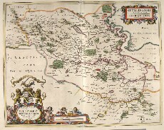
GLOTTIANA Praefectura Superior
The Upper Warde of Clyds-Dail
|
|
| Berwickshire |
Lothians
and Linlithgow |
 |
MERCIA,
vulgo vicecomitatus, Bervicensis / auct.
Timothei Pont. Merce or Shirrefdome of Berwick
|
|
 |
LOTHIAN
AND LINLITQUO/
Joh. et Cornelius Blaeu exc.
|
|
| Stirlingshire |
Teviotdale |
 |
STERLIN-
ENSIS PRAEFE-CTURA, [vulgo], Sterlin-Shyr
/ Auct.
Timoth. Pont
|
|
 |
TEVIOTA
Vulgo, Tivedail / auct. Tim. Pont, Io. Blaeu
excudit.
|
|
| Tweeddale |
Lauderdale |
 |
TVEDIA
cum vicecomitatu Etterico Forestae etiam
Selkirkae dictus, / auct. Timotheo Pont.
|
|
 |
LAUDELIA
sive Lauderdalia Scotis, vulgo, Lauderdail
/ Auct. Tim. Pont.
|
|
| Liddesdale |
Eskdale |
 |
LIDALIA
vel Lidisdalia regio, Lidisdail / Auct.
Timotheo Pont.
|
|
 |
EVIA et
Escia Scotis, Evsdail et Eskdail / Auct.
Timotheo Pont, I. Blaeu excud.
|
|
| Borders
Overview |
|
 |
Overview
maps of river crossings and placenames and
roads implied in texts by or derived from
Pont
|
|
|
| |
|
Top
|
|
|
|
|
|
|
