Tweeddale
Overview
Pont Texts
River Crossings
Placenames
Overview
Two bridges are shown in Peebles, one over
the Tweed and one over the Eddleston Burn which connected
the old and new towns. The crossing at the Manor Water
gave access to the Manor valley and that at Lyme led
down to Stobo where there was another crossing and then
through Drummelzier to Moffat and across to Broughton
and Biggar and Clydesdale. The
crossing at Darnhall was very likely to have been linked
to the road to Edinburgh. That at Caddon Water and the
placename Gatehoopknow are probably connected to a route
on the north side of the Tweed as well as north to Edinburgh
in the case of Caddon water..
Of
the placenames, Craikkesfoorde and Rippeth may have
been connected to monastic holdings in the area. Langatt
was on a later route that crossed the Lammermuirs -
it is not clear where it was heading though Dalkeith
and Haddington are possibilities.
Karlinbrigg and Brigend at Dolphinton were on the early
road from Edinburgh to Biggar and beyond, in places
following the Roman road.
Neidpath near Peebles was on the direct route to Lyme
Bridge but it is not clear if the name refers to the
precursor of the present road or a path running through
the gorge in this area.
Noufird (not shown on Tweedale map) was used by a later
route over to Moffat and Foulbrig Moss was on an early
route though the Manor valley.
Brigend and Brigheuch are connected with bridges known
to have existed in the middle ages. Brigend would have
given access to Lauder and Brigheuch to Peebles via
the Minchmoor route.
Spittell (not shown on Tweedale map) and Spittelhauch
are included as spittels sometimes catered for travellers
but as they did not always do this they are not always
indicative of routes.
The location of Gaitupp is approximate and any associated
route is uncertain.
Texts written by or derived from Pont indicate a number
of routes existed and these are listed below.
Large
map
| River Crossings |
|
Placenames |
|
Note: Langatt, Spittel and Noufird are
not shown on the Tweeddale map

Map based on quarter-inch OS maps, published
1935 & 1945.
With thanks to Ordnance Survey.
Pont Texts
A number of texts written by or derived from Pont gives
distances between towns. It is very likely that these
relate to routes because the distances must have been
measured and there would be little point in knowing
the mileage unless people were travelling between these
places. In some cases he refers directly to "the
way to" or gives a list of intermediate places
as if they were on a route. He also shows river crossings
that must have been used for journeys. There is in any
case evidence from other sources that there were routes
at this time. The texts can be viewed on the NLS Pont
Website and are also in MacFarlane's Geographical Collections.
So far as this map goes, the following entries indicate
routes through this area:
Diverse
distances
Peblis -Edinburgh 16m This is an element of uncertainty
about the course although there is enough evidence to
show that there was a route. Although Edgar
and the Military
Survey show the very direct route through Eddleston,
Howgate and Auchendinny the 1630 map of the Lothians
by Hondius
(based on Pont) does not show a Peebles road. The road
it does show through Auchendinny does not go straight
to Edinburgh as the Military Survey does but joins the
Edinburgh to Biggar road. Moll
in 1718 shows a route through Dalhousie (3 miles SW
of Dalkeith) but the distances on his map add up to
22 miles.
Karlinhops Edinburgh 10 myl This was on the Edinburgh
to Biggar road.
Selkirk Edinburgh 22 m The early route seems
to have used the bridge at Caddon Foot and then went
up by Clovenford
Selkirk Seatonn 22 m This seems an odd inclusion
in the list, perhaps to do with exports. A reasonably
direct route would be the Edinburgh route as far as
Pathhead on the present A68 road and then a cross country
route to Port Seaton.
Peeblis Lanrik 16 m This crossed the Lyme and ran
to Drummelier and Broughton from where Biggar was reached.
Peeblis Lithgow 18 myl The most likely route would
have been up to West Linton and then over the Cauldstane
Slap. The text
accompanying the Blaeu map mentions bridges over the
Lyme at Newlands (just south of Romanno Bridge NT 1646)
and at West Linton.
Biggar Drummailler 4 myl This was on the Clydesdale
to Peebles route.
Annand town in Annandail and
Edinburgh 56, the way is up the hail river annand
to the springs stil north then down Tweed fra the springs
whill you fal in Lothian. the draucht of Tweed falling
that lenth almost nordeast. This description and
an entry for Annand to Muffet suggest the route was
by Moffat then over into the upper reaches of the Tweed
where the route ran down to Broughton and Blyth Bridge.
It is not clear if it then went up through Linton to
join the Edinburgh to Biggar road shown on Hondius.
Edgar
marks this as the Edinburgh to Moffat road but shows
another road that is the present A701 route through
Howgate. Note the wording "the way is up the hail
river..."
Sent
out the south to me in Febr. 1646
Anand and Peebils 36 This would have branched
off the Moffat route at Drummelzier and made its way
through Stobo and Lyme Bridge to Peebles.
Lainrick and Peebils 16 As above
Hamiltoun and Peebils 24 As for Lanark. The Hamilton
to Lanark road ran past Larkhall to Crossford and then
along a ridge past Nemphlar to cross the Mouse by a
bridge dating from the 1600's into Lanark.
Peeblis and Biggar 10 The route went through Broughton,
Drummelzier, Stobo and the Lyme bridge.
Dumfreis Peebils 36 The most direct route would
have been through Moffat and along the Tweed to Drummelzier.
Jedburg Selkirk 8 This would have used the crossing
near Bonjedburgh. MacKenzie in Lilliesleaf and Its Old
Roads (Transactions of the Hawick Archaelogical Society,
1947) gives an interesting account of the two mediaeval
Selkirk to Jedburgh routes, both of which would have
used this crossing. The bridge is mentioned in 1547.
River Crossings
Brig of Lym
Identification
Over River Lyne in vicinity of present day Lynesmill
Bridge at NT 209 401.
Associated route
The Military
Survey and other early maps show this on the route
from Peebles to Drummelzier from where Moffat and Broughton,
Biggar etc. could be reached. Texts written by
or derived from Pont give distances between places that
make it plain that this route existed in his day.
Peebles
Identification
Peebles over River Tweed. NT 250 403. The bridge
(NMRS record) dates from at least late mediaeval times
and replaced an earlier wooden bridge.
Associated route
Early maps suggest this was used for the route to
Selkirk. The town common was on the south side of the
river.
Peebles
Identification
 |
| Cuddy Bridge in distance seen
from Tree Bridge. The old town was on the right
of the picture. |
Earlier bridges at the location of either Cuddy Bridge
or Tree Bridge. Both existed in late mediaeval times
and spanned Eddleston Water. Tree Bridge was at the
foot of Bridgegate. It is hard to say which of these
is represented on the Blaeu map although they are only
a couple of hundred metres apart.
Cuddy
Bridge (NMRS record) NT 250 404; Tree
Bridge (NMRS record) NT 252 405
Associated route
Their main function would have been to link separate
parts of the town although they would have been used
by those travelling through Peebles.
Manor Water,
near to Tweed
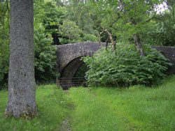 |
| The bridge in the picture dates
from 1702. |
Identification
Manor Water near to Manor Sware and Edston, NT 230 394
Associated route
May have given access to Kirk of Mennyrs (Manor)
sited in Kirkton and would give access to the Manor
Valley. NMRS
record.
Darnhall,
near Eddleston
Identification
Over Eddleston Water near present day village
of Eddleston.
Associated route
On the map the bridge appears to cross over to Barony
Castle (Darnhall, NT 241 471). It is however more likely
that it is linked to the route to Edinburgh which early
maps show crossed the Eddleston Water here to run on
the west side of the river as far as Waterhead. The
old road can be seen on modern maps.
Stobo
Identification
Easton Burn, Stobo. NT 184 376
Associated route
Early maps show a road through here in the mid
1700’s and there is evidence from the texts written
by or derived from Pont that the route from Peebles
went along the Tweed valley to Drumelzier from where
Biggar and Clydesdale could be reached.
Brigend near
Dalfindou
Identification
Bridge-end, Dolphinton NT 108 471
Associated route
This was on the Biggar to Edinburgh road. It coincided
with the Roman road at this point.
Near Cadanly,
just above River Tweed
Identification
Near Caddonfoot on Caddon Water just north of River
Tweed, NT 449 352
Associated route
The Military
Survey shows two roads running from Selkirk here.
One keeps to the east of the Caddon Water and is named
as the "new road" from Selkirk to Edinburgh.
The other road (the old road) crosses the river and
runs on the west side up to Clovenfords where it continues
(as the old road) to Edinburgh. It crosses an east west
road named as the road from Peebles to Lauder which
kept to the north of the Tweed from Peebles. This suggests
the primary purpose of the bridge was to serve the Edinburgh
road although in Pont's day it could easily have tied
in to a route to Peebles. The placename Gatehoopknow
and the record of cannon being transported from Peebles
to Selkirk via Darnick (near Melrose) in 1547 rather
than the Minchmoor suggests such a route did exist (The
Roads that led to Edinburgh etc, Harry R G Inglis, PSAS,
Vol. 50, (1915-16), p. 43).
* also shown on Teviotdale map
At Galasheels,
on river south of Gala Water
Identification
Crossing stream in Galashiels, NT 490 360
Associated route
The orientation of this stream favours a route on
a NW-SE line but it is difficult to say what any through
route might have been, perhaps Selkirk to Dalkeith if
the Tweed was crossed at Boldside (NT 4933) as suggested
by the Military
Survey map. The town of Galashiels did not exist
at the time.
* also shown on Teviotdale and Lauderdale maps
Placenames
Auchincork
Identification
Auchincorth Farm, 4˝ miles NE of West Linton.
NT 197 575
Associated route
Watson (Gaelic Placenames of Scotland) gives the
meaning of Auchencorth as “field of the standing stone”
so it may not have any connotations of a crossing.
Briggend,
near Melrose
Identification
 Bridgend,
2 miles west of Melrose, NT 520 354. Although not shown
here, there was a known bridge
(NMRS record) at this location at the time. Inglis (op.cit.,
p.43 )suggests it may have been destroyed in 1544 at
the same time as Melrose Abbey. Bridgend,
2 miles west of Melrose, NT 520 354. Although not shown
here, there was a known bridge
(NMRS record) at this location at the time. Inglis (op.cit.,
p.43 )suggests it may have been destroyed in 1544 at
the same time as Melrose Abbey.
Associated route
Traditionally it is thought to have been associated
with the Girthgate that ran up to Soutra but Inglis
thinks it would have been used between Lauder and Selkirk,
Hawick and Jedburgh.
* also shown on Teviotdale and Lauderdale maps
Brigheuch
Identification
Near Bridgelands, 1˝ miles NNE of Selkirk, NT 481
304. Kelso Abbey had land on both sides of the River
Ettrick, with pasture rights on part of Minchmoor, granted
them by Alexander II. A condition of the grant was that
they maintain the bridge existing at the Ettrick.
Associated route
There is undoubtedly a connection with the Minchmoor
route both because of the pasture rights and the references
to Minchmoor in Kelso charters relating to Lesmahagow.
That said, it is not completely clear where the route
was. Inglis (Ancient
Border Highways: The Minchmoor (Catrail) Road, the Wheel
Causeway, the Annandale Forest Road, the Well Path,
and the Enterkin, Harry R G Inglis, PSAS, Vol. 58 (1923-24),
pps 203-23) gives an interesting account of the
Minchmoor, noting that there was an original path from
the river crossing which later became turnpiked on its
western stretch between Troquhair and Brown Knowe, where
it ran south to the Yarrow valley. This suggests that
the original Minchmoor road ran from the bridge over
Lingley Hill and Peat Law to the Three Brethren, Broomy
Law and Brown Knowe and then took up the line of the
Minchmoor turnpike to Troquhair. It is not clear, however,
given the absence of the bridge in Pont’s day what the
later status of this route was.
* also shown on Teviotdale and Lauderdale maps
Craikkesfoorde
Identification
Craigsford, on riverside just west of Earlston.
NT 570 382
Associated route
Stobie’s map
(1770) suggests this was used to access Earlston both
from Melrose and St Boswells. It would also have served
local needs.
* also shown on Teviotdale and Lauderdale maps
Foulbrigg Moss,
near Manorhead
Identification
Area at head of Manor Valley. NT 20 26.
Associated route
The first early map to show a route through
Foulbrigg is Armstrong in 1775. The name may indicate
a rough and ready causeway or bridge across marshy ground.
Gatehoopknow
Identification
It appears on the Military Survey and other
early maps 3 miles E of Innerleithen. NT 385 377.
Associated route
See Cadanly
above
Gaitupp, 3
miles east of Troquair
Identification
The mapping is very confusing. Perhaps a mile
or so north of Glentress on road leading north from
Innerleithen but its position in relation to county
boundaries could also suggest somewhere near Redscar
Law, 3 miles east of Glentress.
Associated route
Uncertain.
Karlinbrigg
(in Lothian)
Identification
Carlops on the A702 Edinburgh to Biggar road.
Over North Esk. NT 561 161
Associated route
This is on the mediaeval road to Biggar which itself
followed the Roman road on this stretch.
Neidpetth
 |
 |
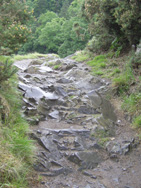 |
| Neidpath Castle |
The Tweed runs through
a gorge near Neidpath |
The path shows signs
of significant wear |
Identification
Neidpath Castle, one mile W of Peebles. NT 23
40
Associated route
A castle has existed here from the 1200’s and its
position strongly suggests that it guarded a natural
pass on an east west route even in early mediaeval times.
It is difficult to say what path the name refers to
although it probably means the "nether" path
(see guide Neidpath Castle for this suggestion).
This "nether" path could be the path that
runs beside the river or it could be the precursor of
the present road which is shown on early maps. Given
the known route from Drummelzier through Stobo and across
the Lyme bridge as well as the evidence of early maps
it is more likely that in Pont's day the road ran on
the same line as the present day road.
Another road runs westwards above the present day road.
This has been identified as Roman and runs from Newstead
to Lyme. It is thought that it took this route to avoid
the steep sides of the valley (Roman
communications in the Tweed Valley, Graham, A & Richmond,
I A., PSAS, Vol.87, (1952-53), 63-71).
G.C.Pringle in the Cambridge
County Geography for Peebles and Selkirk (copy on
Electric Scotland site) suggests the difficulties of
this stretch and the lack of bridges over the Lyne led
to the route from Clydesdale coming by Broughton and
Drummelzier.
Rippeth
Identification
Redpath, 2 ˝ miles SSE of Earlston, NT 585 385
Associated route
Given the presumed age of this place name it is
tempting to think that a road would have ran north through
here from Dryburgh Abbey but there does not seem to
be any record of such a road. Another possibility is
that it was on a road between Melrose and Earlston but
early maps do not support this.
* also shown on Teviotdale, Merse and Lauderdale maps
Spittelhauch,
near West Linton
Identification
Spittelhaugh about 2 miles SSW of West Linton.
NT 161 493
Associated route
There is a tradition of a mediaeval chapel here
and possibly a spittal but there is insufficient information
to link the site to any route.
NMRS
record.
Top
|


