|
Edinburgh
Parish
map (Gellatly, New Map of the country 12 miles round
Edinburgh, 1834. - National Library of Scotland)
OSA
Bridge
in Leith
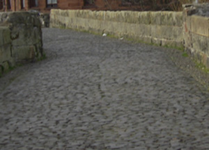
p. 574 Leith had an old stone bridge (image)
which was built by Holyrood Abbey and rebuilt in 1602.
There were tolls for animals and for people with burdens
but none for carriages. The bridge was removed to help
enlarge the harbour - there is now a new drawbridge
nearby. There is one turnpike in the parish with a toll
near the church.
Cowgate, Mound etc.
p. 584 In Edinburgh a bridge of 22 arches was built
over the Cowgate in 1783. To link the Old and New Town
a huge mound 800 feet long was created across a morass.
The earth sank as much as 80 feet when the mound was
being created.
Stage
coaches
In contrast to 1763 when there were only two stage
coaches (image) to Leith running hourly and taking
one hour for the journey, by 1783 there were 5 or 6
coaches running every half-hour and taking just 15 minutes
for the journey of 1 � miles. In 1763 the only other
stage coach in Scotland was a monthly coach to London
that two between 12 and 16 days for the journey. By
1783 there were frequent coaches to all the main towns,
and 15 coaches a week to London, taking just 4 days
or less for the journey.
There were very few hackney coaches in 1763 but they
had tripled in number 20 years later and were now very
good.
NSA
Streets
post
office
Coal
Details are given of the streets, the New Town,
The Mound, George IV Bridge etc.
The first regular post to London was in 1635. It came
under the government in 1649.
There are 90 stage coaches on various routes and 200
hackney coaches, cabs, and omnibuses in the city.
Coal comes from Dalkeith, Tranent, and western districts.
Borthwick
OSA
Market in Dalkeith. Middleton has an inn and post
office and post chaises can be hired.
NSA
Gypsies
Roads
A bridge was carried away in 1837 by an exceptional
flood.
Coal and lime are available in the parish - most of
the coal goes to Galashiels, Peebles and Selkirk.
The bye-roads are poor as the statute labour funds are
inadequate to keep them in good repair.
The village of Clay Houses takes its name from an ancient
inn that was sited on the old road that went to Gala
Water and the south. The village of Middleton used to
be very busy, being on the road south though the new
road has a different line.
There are many gypsies here, now mostly married into
the local population. In the summer, some can be seen
camping on quiet bye-roads or beside hedges where their
tents are unlikely to be seen. They make hand-made items
which are sold to the local people.
The great road to the south passes through and there
are several inns along its length.
Mid Calder
OSA
Almond
Roads
Archaeological finds suggest that at some time the
Almond between Livingstone and Kirkliston was an important
boundary, perhaps defended by the Picts and Scots against
the Saxons when they were moving up to the Forth. The
roads are good and travel to the main towns is easy.
NSA
Roads
The Pentland Hills with Cauldstane
Slap on right
The Cauldstane Slap over the Pentlands is used by drovers,
and in the summer can be crossed by riders.
Three public roads run through: the Edinburgh to Glasgow
road to the north; the Edinburgh to Ayr road to the
south and the Edinburgh to Lanark road by Carnwath.
The writer reiterates the previous account of the Almond
being an important pass in historical times.
Castle
Greg Roman Fort
There is a Roman camp at Castle Greg where many
Roman coins have been found.
Markets
There is no weekly market. The main market town
is Edinburgh; very few go to Bathgate and Linlithgow
markets. Two annual fairs are held. Coal is very expensive
due to the demand from iron works and for steam engines.
More attention is now being given to peat.
See also Account
of the Parish of Mid-Calder, John Sommers, 1838
on the Googlebooks site. There is a search facility.
West Calder
OSA
Roman
camp
 No
particular mention of roads. Six carriers live in the
parish. Roman camp at Castle Greg. No
particular mention of roads. Six carriers live in the
parish. Roman camp at Castle Greg.
NSA
No particular mention of roads. There is a small
Roman camp at Castlecraigs. Dairy produce is taken to
the Edinburgh market.
Castle Greg
Primrose,
or Carrington
OSA
The statute labour raises 18L yearly and is rated
at 18d per plough gate. There are 10 miles of road which
till recently were very bad and in many cases, not even
started. Some local people who saw the advantages of
good roads, repaired some at their own expense, built
two small bridges and lessened two steep stretches.
The Peebles to Dalkeith road which runs through here
and Dalhousie has taken much of the parish funds. If
funded by the toll at Dalkeith, there would be enough
money to fund the other roads in the parish.
NSA
No mention of roads.
Cockpen
OSA
No particular mention of roads. There is a bridge
over the South Esk at Cockpen. A very large market is
held at Dalkeith each week.
NSA
Dalkeith is the nearest market town. Three turnpikes
run through: Edinburgh to Carlisle; Dalkeith to Peebles;
and Dalkeith to Noblehouse. There are 3 tollbars and
3 bridges, over the South Esk. Coal is available locally.
Colinton
OSA
"Edinburgh dung" (stable and street dung) is carted
in from Edinburgh for use as manure. The roads are funded
by the statute labour. Two cairns were destroyed when
making a turnpike road.
NSA
Roman
Road
The Roman road that ran from York to Carriden near
Abercorn passed through Comiston farm. The high road
between the toll and Bow Bridge is very close to its
line.
Roads
Edinburgh is the nearest market. There are post
offices at Colinton and Slateford. A turnpike road goes
to Lanark and another joins the Biggar road at Fairmilehead.
There are no tolls in the parish. Statute labour is
commuted and the roads are good. A coach from Lanark
and a noddy from Currie travel on the Lanark road. Four
bridges. The Union canal passes through the parish.
Corstorphine
OSA
Street dung is used as a manure. The two great Glasgow
roads pass through the parish which make it easy to
get to Edinburgh. There have been discussions about
a canal but this has not been favoured locally. In the
past, the area was often flooded and was very marshy.
Goods had been brought to Corstorphine House from Coltbridge.
NSA
Fruit, strawberries and vegetables are taken to
the Edinburgh market. In 1749 there were 8 or 9 coaches
a day between Edinburgh and Corstorphine at a fare of
6d. This shows the popularity of the place as there
were only 3 daily coaches to Musselburgh and a stagecoach
to Glasgow twice a week. The Glasgow road and that to
Falkirk and Stirling pass through and there is much
traffic although no coach specifically from here to
Edinburgh. There used to be 4 fairs.
Cramond

Cramond looking east
OSA
There is a large ironworks here and coal is brought
from the Grange, near Bo�ness. The roads are very good.
They are made of small pieces of broken granite and
covered with the rubbish from the sides and the ditches.
The Edinburgh to Queensferry road runs through here
and is one of the busiest in Scotland. It crosses at
Cramond Bridge. There are 2 coaches and 4 chaises in
the parish.
NSA
Roman
fort etc ; see
also
Bridges
There is a Roman road and fort here. The fort and
harbour seems to have had a link to the Antonine Wall
at Carriden and also to the south by a road running
towards Edinburgh, the east end of the Pentlands and
the Eildons. Part of the stretch to Edinburgh could
be seen about 100 years ago, though badly damaged by
ploughing. It is thought that there are still remains
in the grounds of Cramond House. Maitland in his history
says that it could be seen on Echlin Moor near Queensferry
and near a burn at the east end of the Pentlands. Around
1700, a section of Roman road on the coast was discovered
in Leith, crossing the river and heading for Cramond.
In 1607, Cramond Bridge (image)
was ruinous and impassable. It was repaired in 1619,
1687 and 1776. It has similarities with Bothwell bridge
and Maiden Bridge over the South Esk. A new bridge was
built in 1823 by Rennie and is crossed by the excellent
Queensferry road.
See also The
Antient and modern state of the parish of Cramond,
John Philip Wood, 1794 on the Googlebooks site. There
is a search function.
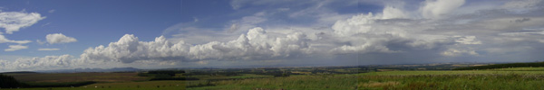
Cranston
 |
| Lothian viaduct at Pathhead |
OSA
No particular mention of roads. Grain etc taken
to Dalkeith. There was a nunnery at Cousland. The old
manse near Prestonhall is thought to have been a resting
place for the religious on their way to Melrose.
NSA
A new line of road has been built between Pathhead
and Fordel. The nearest market town is Dalkeith. Two
turnpikes pass through. There are 4 carriages on the
high road each day as well as wagons. Two new bridges
have been built to shorten the line of the London road
by Cranston church and Pathhead: Cranston Dean bridge
and Lothian bridge, both designed by Thomas Telford.
Also on this stretch of road, there is a new embankment
over 50 feet high in places. The distance saved is 1200
yards.
Crichton
 |
| Pathhead |
OSA
The road to Cornhill and Kelso passes through the
parish. There is a market in Dalkeith. Lime is supplied
to areas south of here.
NSA
Limestone from here has been used for building in Edinburgh
and is used as manure in parishes to the south. The
great road to the south, leading to Lauder, passes through.
At Pathhead a fine new bridge has been built. Pathhead
has a post office with daily posts and there are four
coaches to the south each day. The market town is Dalkeith.
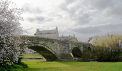
Currie
OSA
Forty years ago the roads were so bad that everything
was carried on horseback. The improved roads allow a
much greater weight to be taken by cart - one horse
can now pull two tons. Because of its convenient situation
near to Edinburgh, smugglers from Ayrshire used to frequent
the parish. The roads are very good. The upper road
goes to Lanark and Ayrshire and the lower road is the
common Glasgow road, passing through Hermiston. Barley
is exported to the West Indies and rum and sugar are
received on return. A quarry at Balerno has been used
in the building of the New Town.
NSA
Manure is brought from Edinburgh by canal. The bridge
in Currie (also general
view including bridge) is thought to be more than
500 years old.
Mention of place name Enterkin�s Yett or Gate.
Near Kenleith, a "hidden and narrow pass" led over the
Pentlands.
Large numbers of people travel to the Edinburgh market.
The roads are very good and constantly improving. Apart
from a bridge near Hermiston (recently widened) the
bridges are very old. The turnpike to Lanark with a
daily coach passes through Currie and the Glasgow, Ayr
and Hamilton turnpike runs through Hermiston. Post is
brought on foot from Colinton twice a day.
Dalkeith
OSA
Market
Bridge
There is a very large grain fair and other fairs
as well. Grain is taken to Carron, Glasgow and Paisley.
A bridge over the North Esk to Dalkieth House has been
built recently.
 |
 |
| The Old Mealmarket
Inn in Dalkeith |
NSA
Salter�s
Road
In 1503, Margaret, daughter of Henry VII and to be
married to James IV, arrived from England and travelled
by Lamberton, Fast, Dunbar, Haddington, Newbattle and
Dalkeith. Between Haddington and Newbattle she seems to
have come by the "Salter�s Road" (now
the A6094) and the Maiden Bridge.
Roman
road
There is a footnote referring to traces of a Roman
road as seen in 1707 running from Musselburgh to Lugton
and Borthwick Castle.
Market
A description is given of the roads in the town. A
major market is held here where grain is brought from
the counties of mid and east Lothian, Berwick, Roxburgh,
Selkirk and Peebles. Unsold grain is kept in granaries
until the next market, enabling the carts to return home
with other goods. There is a post office in the town.
Eight miles of turnpike and frequent coaches. The first
stage coach to Edinburgh was in 1783.
Bridges
There were two bridges in Dalkeith in 1594 (note:
one was the Cowbridge), over both the North
and South Esk. Even then they were old and in poor condition
as shown by an act of parliament which was required for
their repair. They were badly damaged by floods in 1659
but again repaired with a toll being exacted to defray
the expense of repair.
To avoid the toll, people started using a ford over the
south Esk leading to the west of Dalkeith and a ford at
Elginhaugh but tolls were soon levied at both fords. Further
repairs to the bridges were needed after floods in 1681.
A new bridge over the North Esk was built in 1765, near
the old one, and improved in 1816. Another bridge was
built in 1756 and crossed the South Esk at Newmills and
has been improved at various times. In 1797 a bridge was
built at Elginhaugh. All the bridges are in excellent
condition except for the Cowbridge
on the road to Musselburgh. Details are given of the Edinburgh
and Dalkeith railway. There are several fairs each year.
Coal is plentiful. Since the last Account, new roads and
bridges have been built and there are numerous stage coaches.
Duddingston
OSA
Fishwives'
Causeway
Around 1700 the farmers were paid to remove the
street dung from Edinburgh. The roads of the time were
very bad and often impassable in winter. Goods were
carried on horseback in sacks, hurdles or creels, though
carts were used on the east side of Edinburgh before
1750 and on the west side after that date. The salt
pans on the coast give employment for 40 carriers, all
women, who travel to Edinburgh and the surrounding district.
There is an ancient causeway to the north-east which
forms the boundary of the parish there. Some think that
it is one of those roads, several of which lead to Holyrood
Palace, that Mary Queen of Scots was keen to encourage
to help develop Scotland. Mary is known to have granted
privileges to corporations and individuals if they made
and maintained certain roads and paths. The road in
question is the "Fishwives' causeway" which was part
of the post-road to London. Linlithgow and Peebles are
said to have had a responsibility for maintaining this
causeway.
NSA
Fishwives
Causeway
The writer reiterates the previous account of the
road (Fishwives� Causeway) forming part of the parish
boundary noting that some think it Roman (between Inveresk
and Cramond) and others that it was one of the roads
Queen Mary (Mary Queen of Scots) promoted.
Roads
Before the 1750�s, 36 horses were used to carry
coals to Edinburgh in sacks and creels.
No markets here but provisions are obtained at Portobello.
Hourly coaches run between Portobello and Edinburgh.
The London road passes through the parish. Roads are
very good. A more direct road from Wester Duddington
to Edinburgh has been proposed. There is a rail road
which gives cheap and easy access to Edinburgh, Dalkieth,
Leith, Musselburgh etc. Coal is easily obtained.
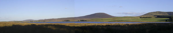
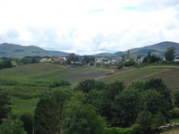
Fala and Soutra
 |
| General view from Soutra Hill |
OSA
 |
| Soutra Aisle |
A hospital
was founded on Soutra Hill by Malcolm IV in 1164 to
help pilgrims and poor and sickly people. A road, called
the Girthgate from the Gaelic for asylum or sanctuary,
ran from Bridgend, near Dornick (just west of Melrose)
across the moors to Soutra. It seems to have been a
sanctuary, hence the name Girthgate. Much of the road
can still be seen today.
NSA
p. 534 Twelve stage coaches run each day on the Edinburgh
to Lauder road that passes through here. The road crosses
the Dean Burn on an embankment.
p. 536 Details of the hospital at Soutra are reiterated.
Half a mile south of the ruins there is a spot called
the King�s Inch on the Girthgate which has always been
used by drovers.
Glencorse
OSA
The Biggar, Moffat and Peebles roads run through
the parish. Sheep market at House of Muir where sheep
from Galloway and the south are sold.
NSA
Markets are in Edinburgh and Dalkieth. The nearest
post offices are Penicuik and Roslin. Two turnpikes
run through the parish as well as the old Dumfries road
by Auchindinny. Coaches pass through each day for Peebles
and Dumfries. The parish roads are very good. Statute
labour funds total 20L yearly. There are 3 stone bridges
over Glencross water and one over the Esk at Auchindinny.
An annual sheep market is held at House of Muir and
is well attended from all over Scotland. Up until 40
years ago there had been a weekly market for beef. Coal
is used as fuel.
Heriot
OSA
Grain is taken to the Dalkeith market. The roads
here, particularly the Gala-water road, are good. This
road runs through Lasswade, Cockpen, Middleton, Heriot,
Bankhouse, Selkirk etc on route to London. The old staging
point from Edinburgh was Heriot public house though
it is less used now since inns were opened at Middleton
and Bank-house. There is one toll, near Heriot house.
Coal, peat and turf are used as fuel. Coal is obtained
from Stobhill about 7 miles away.
NSA
There is a market at Dalkieth, and post office at
Fushie Bridge, 7 miles away. A turnpike runs through
the parish for 3 miles and a new turnpike to Innerleithen
for a distance of 4 miles. Parishoners of Stow parish
living north of the Arnuilt or Crookston Water find
it easier to attend Heriot church because of the long
distance to their own church.
Inveresk
OSA
Romans
Magdalene Bridge lies in the parish and there is
thought to be a Roman camp here where a causeway ran
from the port (at Fisherrow near the bridge) to a camp
at Sherrifhall, 3 miles to the south-west and then onwards
to Borthwick.
Musselburgh Bridge
Old bridge
Some think Musselburgh
Bridge (RCAHMS details) could be Roman.
Fishwives
There is frequent communication with Edinburgh with
fishwives, carriers and stagecoaches going there all
the time. Sixty three people employed as carters.
Post Office/Roads
Town Centre, Musselburgh
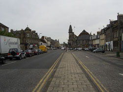 The
Post Office requires London letters to be taken to Edinburgh
and then back here with a one penny surcharge even though
the mail coach passes through Inveresk. This is very
much considered a grievance. The
Post Office requires London letters to be taken to Edinburgh
and then back here with a one penny surcharge even though
the mail coach passes through Inveresk. This is very
much considered a grievance.
The roads here are thought to be the worst in Mid-Lothian.
This is thought unjust in view of the amount of money
spent on tolls by people here on journeys to Edinburgh
and Leith, and the fact that the large number of carriages
here are under the county. The roads to the coal pits
are better and the causeyway or pavement of the streets
are fairly reasonable. The footpaths, however, are "shamefully
dirty" and detours forced round enclosures have made
journeys to Dalkieth and Musselburgh much longer and
result in having to walk in mud over the shoes for some
distance. (A note says that the county have now repaired
the post road through the parish).
NSA
Romans
There are considerable Roman remains in the area
including a camp and roads. One of the roads ran from
Borthwick to the Shire-haugh and then the harbour at
Fisherrow. Another went west to the south of Portobello
into Currie parish. Part of the road in Duddingston
parish is known as the Fishwives� Causeway. One of the
two stone bridges over the Esk between Musselburgh and
Fisherrow is likely to be Roman as it lies between the
camp and the harbour and traces of the road could be
seen on its approaches from either side.
Mediaeval
In early mediaeval times the magistrates of Musselburgh
were allowed to collect tolls at the western edge of
the parish to upkeep the Roman bridge and the streets
of the town. The toll is still in operation at the Magdalen
Bridge. There is charter evidence for roads in the "Scoto-Saxon"
period such as mention of Derstrette near Colden in
this area, a Via Regia from Ford to Newbottle Abbey,
and the King�s Highway from Newbottle to Edinburgh.
Pilgrims came from all over to the chapel of Our Lady
of Loretto in Musselburgh.
Roads
 The
London road runs through and good roads lead to Dalkeith
and the lime kilns to the south. There are daily coaches
to London and frequent coaches from Dunbar, North Berwick
and Haddington. Both coaches and trains run to Edinburgh
nearly every hour. Apart from the old Roman bridge (now
a footbridge) there is a fine new bridge by Rennie built
in 1806-7. There are also two wooden bridges. Slaughtered
sheep are to be seen hanging beside the streets in the
town. One fair is held where a lot of business used
to be carried out but no longer. Coal is obtained locally. The
London road runs through and good roads lead to Dalkeith
and the lime kilns to the south. There are daily coaches
to London and frequent coaches from Dunbar, North Berwick
and Haddington. Both coaches and trains run to Edinburgh
nearly every hour. Apart from the old Roman bridge (now
a footbridge) there is a fine new bridge by Rennie built
in 1806-7. There are also two wooden bridges. Slaughtered
sheep are to be seen hanging beside the streets in the
town. One fair is held where a lot of business used
to be carried out but no longer. Coal is obtained locally.
Kirkliston
Although the parish was divided
by the River Almond into a western part under Linlithgowshire
(West Lothian) and an eastern part under Edinburghshire
(Mid Lothian), the Statistical Account deals with it
under Mid Lothian.
OSA
No specific mention of roads. The writer refers
to the tradition of an early conflict in the area suggesting
that this shows the strategic importance of the Almond
(see also Mid Calder parish).
NSA
Details are given of archaeological finds relating
to the tradition of a battle fought in the area. There
are markets at Edinburgh, Linlithgow and Bathgate. There
is a post office in the village. Three turnpikes pass
through: the Edinburgh to Stirling, Glasgow by Falkirk,
and Glasgow by Bathgate from which there is a branch
to Queensferry. There are frequent coaches and carriers
on these roads.
Two bridges over the Almond, one on the Stirling road
and the other on the Falkirk to Glasgow road. Mention
is made of the "usual fords" in relation to difficulties
getting to the church when the Almond is flooded.
Kirknewton
OSA
The Glasgow to Edinburgh road passes through the
parish.
NSA
Dairy produce is taken to Edinburgh. Limestone from
near East Calder is used for building and agriculture
and also at iron works in Lanarkshire and for purifying
gas. The Edinburgh to Glasgow road runs in the north
of the parish, and the Edinburgh to Lanark road in the
south, with connecting cross-roads. The Glasgow mail
coach has been supplanted by the railway though mail
is still taken to Hamilton by coach. Coaches go from
Mid Calder to Edinburgh, three times a week and Lanark
to Edinburgh every two days. The canal is three miles
away; Ratho station, five miles. Carriers run from Kirknewton
and East Calder to Edinburgh. The post office is in
Kirknewton.
Lasswade
 |
 |
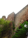 |
| Near Roslin |
Near Roslin |
Roslin Castle |
| With
thanks to Adrian Minton |
OSA
No mention of roads.
NSA
 The
Cast
The
Cast
There is a ford over the North Esk at Springfield
from which a road runs south-easterly. It is very narrow
and in places nearly 6 feet below the general surface
and was probably a Roman road. It is called the Cast
which may come from Via ad Castra.
Roads
The nearest markets are in Edinburgh and Dalkeith
and there are two post offices in the parish. Twelve
miles of turnpike. A coach runs to Edinburgh several
times a day going by Loanhead, The Dumfries mail coach
and another from near Penicuik pass through on their
way to Edinburgh.
Liberton
OSA
The Society of Carters hold an annual procession.
NSA
An annual procession by carters is followed by a
race on the public road.
There is a very large coalwork at Gilmerton. Many carters
drive the coals to Edinburgh.
There are markets in Edinburgh and Dalkeith and a penny
post office is linked to the main post office in Edinburgh.
There are many excellent roads. The London, Dumfries,
Musselburgh and Dalkeith roads pass through as well
as the railway to Dalkeith. Parish roads are excellent.
In total there are 12 miles of turnpike and daily coaches
to Lasswade, Dalkeith, Jedburgh, Carlisle and Peebles
as well as the mail coaches to Dumfries and London..
Newbattle
OSA
Bridge
No specific mention of roads. There may be a Roman
camp two miles south of Morebattle. At the east end
of Newbattle there is a very old
bridge, crudely built and covered with ivy.
NSA
There may have been a Roman camp here. There is
a very old bridge over the Esk. Markets are in Dalkeith
and Edinburgh. No post office. Fuel is obtained locally.
There are 12 miles of turnpikes and these road are very
busy. There are also parish roads though these are badly
damaged by coal carts. However, work has started on
a complete repair of these and as the rail road will
transport much of the coal the situation should improve.
There are four bridges over the Esk as well as a railway
bridge.
Newton
OSA
No mention of roads
NSA
Markets in Edinburgh and Dalkeith. The turnpike
to Lauder by Dalkeith passes through as do the roads
from Leith to Dalkeith and Dalkeith to Musselburgh with
linking roads, also turnpikes. These, and the parish
roads are well kept. There are frequent coaches to Edinburgh,
Dalkeith, Lauder, Duns, Newcastle etc. The railway is
very convenient. Post office in Dalkeith.
Penicuik
Note: For additional information on
roads in this parish see Annals
of Penicuik, John J Wilson, 1891 on Electric Scotland
site.
OSA
Roads
; see also
There are two main roads: one to the north of the village
goes to Linton and Biggar; the other, one mile to the
south-east, goes through Howgate, branching to Peebles
and Noblehouse. A convenient by-road was made to Howgate
recently, and a road is being built from the Linton
road across the hills to the east of the parish which
had previously been difficult to reach. Peat and coal
obtainable locally; peats are carried to Edinburgh.
The turnpikes are very hilly and the by-roads few in
number and in poor condition. There is a danger of wasting
money on improving roads that are poorly planned, badly
made and too narrow.
Spittal
etc ; also
 Place
names such as Monk�s Ridge, Monk�s Road, Monk�s Burn
suggest a connection with monks, perhaps Cistercians.
An old track on which a cross stood runs over the Pentlands
and there is another path nearby called the Monk�s Path
which points in the same direction and on which there
is a stone basin, perhaps a font. The Monk�s Path points
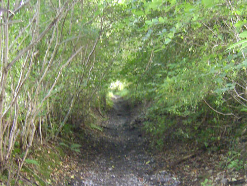
towards Queensferry and Edinburgh. There were two spittals
in the area - there is still an outhouse with straw
at the present Spittal farm where travellers can stay. Place
names such as Monk�s Ridge, Monk�s Road, Monk�s Burn
suggest a connection with monks, perhaps Cistercians.
An old track on which a cross stood runs over the Pentlands
and there is another path nearby called the Monk�s Path
which points in the same direction and on which there
is a stone basin, perhaps a font. The Monk�s Path points
towards Queensferry and Edinburgh. There were two spittals
in the area - there is still an outhouse with straw
at the present Spittal farm where travellers can stay.
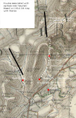
(Note: there are additional details in
The Statistical Account of Scotland 1791-1799 Vol. 2:
The Lothians, Wakefield, England: EP Publishing Ltd.,
1975, pps 388-9 that give a clearer picture of where
the spittals and the Monk's Path were. The Back Spittal
was beside the Esk about one mile north of Carlops beside
a track leading northwards. The Fore or Old Spittal
was near to Spittal Farm and the Monk's Road led north
from here past what is called the Font Stone which may
have been a cross. The Monk's Road may have joined a
track near to West Kip Hill and is said to have ran
to Queensferry as a pilgrim route. See map for summary.)
Font
Stone; Back
Spittal; (Spittal
Farm) Fore or Old Spittal (Canmore entries from
RCAHMS). The Monk's Road is shown on the 1st edition
one inch map,
sheet 32 Edinburgh (National Library of Scotland).
NSA
Spittal
etc
There may have been a religious establishment at
Newhouse at some time. There is a nearby farm called
the Spittal from where a pass crosses the Pentlands.
A cross stood at its highest point. Even today travellers
can obtain shelter at this farm.
Roads
 There
is a wide tract of moorland south-west of Penicuik through
which two turnpike roads pass. There are 2 annual fairs.
Several turnpikes run through: the old road to Dumfries
by Howgate; the new road by Penicuik and a much improved
line by Nine-mile-burn; a new turnpike between Penicuik
and Linton; and one between Penicuik and Nine-mile-burn. There
is a wide tract of moorland south-west of Penicuik through
which two turnpike roads pass. There are 2 annual fairs.
Several turnpikes run through: the old road to Dumfries
by Howgate; the new road by Penicuik and a much improved
line by Nine-mile-burn; a new turnpike between Penicuik
and Linton; and one between Penicuik and Nine-mile-burn.
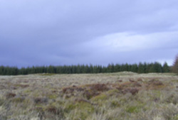
Pentland Hills from Auchencorth Moss
Ratho
OSA
Manure brought from Edinburgh. The Edinburgh to
Glasgow road runs through and there is a bridge at Addiston.
Coal is brought from Bonharr, 17 miles away- the roads
there are good.
NSA
The nearest market for farm produce is Edinburgh.
In the past there used to be a cattle market here.
There is a post office with deliveries twice a day by
runner from the mail coach which passes through on the
turnpike. Two main roads run near the parish: both are
between Edinburgh and Glasgow, one by Uphall, the other
by Calder. The canal has proved very beneficial allowing
the transport of coal and manure and there are now passenger
boats which travel at 8 or 9 miles per hour. A railway
is proposed. There are 14 miles of very good parish
roads, funded by a rate on ploughgates. A carrier travels
to Edinburgh twice a week.
Roslin
This was an ecclesiastical
parish formed out of Lasswade in 1834, rather than a
civil parish, hence there is no OSA entry.
NSA
Coins, probably of Edward I, were found on the public
road at Harper�s Hall Brae. Markets at Edinburgh and
Dalkeith. There is a post office here. Five miles of
turnpike including one mile of the Dumfries road. Coaches
from Dumfries, Peebles and the Wellington Inn pass along
this road on their way to and from Edinburgh. There
are not enough bridges - the slopes in the valley of
the Esk are very steep.
Stow
OSA
In 1754 the Edinburgh to Selkirk turnpike was built
and resulted in a total change in farming as it made
it easy to transport lime to fertilise the ground.
NSA
Romans
Remains of Roman camps in the parish; some may have
been signal stations along the valley.
Roads
Stream called Lugate, formerly Lowgate.
The local market towns are Galashiels, Selkirk, Lauder
and Dalkeith. Post office in Stow village which was
transferred there from Stagehall in 1819 when the new
road was opened. The mail coach from Edinburgh to Carlisle
and London started in 1807; before that time the post
was brought by horse or runner from Melrose. There seems
to have been a postal service since 1703.
Some 30 years ago the only coach on the road was the
Jedburgh Fly which ran to Edinburgh twice a week. It
was a "sort of wretched post-chaise" carrying 5 passengers
and the driver.
 A
bridge was built in Stow over the Gala Water in 1654-5.
Another bridge was built in 1815 to connect the new
road with the Selkirk road, and one in 1829 about a
mile upstream to connect the old and new roads. In 1831
one was built at Pirntaiton and another 30 years ago
near Torwoodlee to give access to the new road, part
of which had been completed nearby. There is also a
bridge over the Lugate Water. A
bridge was built in Stow over the Gala Water in 1654-5.
Another bridge was built in 1815 to connect the new
road with the Selkirk road, and one in 1829 about a
mile upstream to connect the old and new roads. In 1831
one was built at Pirntaiton and another 30 years ago
near Torwoodlee to give access to the new road, part
of which had been completed nearby. There is also a
bridge over the Lugate Water.
One annual fair is held. There is a fine inn at Torsonce,
just north of Stow. Coal is brought some 15 miles from
the north.
Stow Bridge
Temple
OSA
Dalkeith market used. Improved roads will lead to
improvements in agriculture by making it easy to take
produce to market.
NSA
Dalkieth is the nearest market town. There is a post
office at Fushie Bridge. The turnpike from Peebles to
Dalkeith runs through the parish for about 6 miles.
There are no public carriages on this road, only weekly
carriers from Temple and Rosebery to Edinburgh.
Top
|


