|
Overview
There are a couple of references to the Roman camp
at Lyne and an associated road, and quite a few references
relating to the middle ages. Thus Peebles was on the
way to the Ettrick Forest, a favourite hunting reserve
for the court and it is thought this may have been the
reason for building a bridge in Peebles. There was a
"hospitium" at Eshiels for travellers and
for the elderly and sick. There are also references
to very early roads, including a "Thief's Road".
One road between Traquhair and Selkirk ran over
the Minchmoor and there is mention of a cross on the
southern edge of the county indicating that a route
came up from Moffat and then along the Tweed valley
where at Drummelzier, a landowner had a habit of waylaying
travellers and exacting a toll from them. The Tweed
was fordable in this area though the water was one and
a half foot deep. Towers were built within sight of
each other so that signals of any incursion could be
sent quickly.
As elsewhere in Scotland, the county shared in the
general pattern of building roads under the statute
labour system, and later under the turnpike system.
The statute labour was generally commuted although no
money had been collected in Broughton for some ten years
hence roads other than the Moffat road were very bad.
The roads in Skirling suffered greatly from the transport
of lead from Leadhills and Wanlockhead.
There were several turnpike roads and those few inns
on the main roads, e.g. Crook, Beild and Tweedshaws
served as hubs for the post, for carriers, and for catching
coaches. Some had post chaises and horses for hire.
Two cadgers who bought eggs, poultry and skins for Edinburgh
are mentioned in the Broughton account. There had been
a tragedy in Tweedsmuir where the driver and guard of
a mail coach were caught in a snowstorm and tried to
complete the journey on foot.
Depending on location, coal was brought in from mid-Lothian,
Douglas and Wilsontown. Fairs were held in Broughton,
Peebles and Skirling, and Tweedsmuir used Biggar as
its market town. There were long established sheep markets
in Linton on the south side of the Cauldstane Slap.
There had been plans for a road over this pass and this
was made as far as Badensgill but the gentlemen on the
north side of the "slap" showed no interest
in this. Plans for a railroad between Glasgow and Berwick
via Peebles had been abandoned.
Other Resources
A
History of Peeblesshire, William Chambers, 1864
- contains many references to roads and bridges.
New Statistical Account
The NSA links below are to this point where the
original accounts can be accessed (for Lyne & Meggat
see p.166). Use the back button on the browser to return
to parish account.
Broughton
OSA
Coal is brought from 16 miles away and lime from 12
miles away. The public road to Moffat is in good condition
but the bye-roads are very bad and many are impassable.
No statute labour has been carried out and no commutation
money has been collected over the last ten years.
There is a bridge on the public road over the Biggar
Water, a quarter of a mile from the village which is
very useful as the river was often impassable in winter.
There is a fair in October which used to be for black
cattle - now it is mostly for hiring of servants and
the selling of cheeses.
NSA (now parish of Broughton,
Glenholm and Kilbucho)
In a tale about an incident involving one of the Scottish
kings, perhaps James IV, it is related that Sir James
Tweedie, resident in Drummelzier Castle was in the habit
of exacting tribute from travellers.
Old roads are usually hilly - it was thought impossible
to build a road on wet and marshy ground so high firm
ground was sought. This did not matter so much when
there were no wheeled carriages. Another feature of
older roads is that they often detoured round the estates
of country gentlemen.
These difficulties are now being overcome by the new
toll road, three miles of which has already been built
on a new line and two miles soon to be started. There
is one toll bar with rates such as 3d for a horse, 1/6
for a carriage with two horses, 4d per score of sheep
etc. The mail coach passes through daily; and last summer,
the "Hero", a light coach ran every two days.
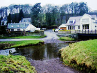
 |
| Part of parish looking south
from the Biggar to Broughton road |
The Peebles to Biggar road which runs through here
is the worst road in this area but it is being repaired.
A road bill proposes a new road from Peebles to Biggar
on a level course and survey work for a rail road from
Glasgow to Kelso which will pass through or near this
parish has been completed.
Eight miles of toll road run through and there are parish
roads, one forming part of the Peebles to Biggar line
and another running through Kilbucho to join the Biggar
and Culter roads.
There are three bridges on the turnpike, and over the
Kilbucho and Broughton burns as well as some smaller
ones. The older bridges are narrow.
There is a market at Biggar. An annual fair is held
here which used to be for the sale of cattle. The inn
at Broughton is used as a stage by the coaches. The
inn at Rachan Mill is at the junction of the Peebles
to Moffat and the Edinburgh to Dumfries roads. Coal
comes from Ponfieth, 18 miles away.
Notes from "Annals of a Tweeddale Parish",
Rev. Andrew Baird, Glasgow 1924
p. 18 He gives a poetic description of the arrival of
the mail coach with the sound of the horn in the distance,
the change of horses, the scarlet coated guard, passengers
eating a hasty meal, the unloading of the mail bags,
people discussing news, and then the quiet after the
coach had drawn away.
p. 20 Roads were extremely bad and only improved after
the passing of a Turnpike Act in 1751. In 1617, on the
return of James VI to England after a visit to Scotland
his carriage and household effects were routed through
Broughton to Dumfries - horses had to be supplied for
the journey, with a fine and imprisonment for defaulters.
p. 24 A drove road passed through - it came from Falkirk
by Skirling and Broughton, then by the head of Tweeddale
into Yarrow from where it passed into Ettrick and Liddesdale
and then over the border into England.
p. 55 A former Minister here, the Rev. Hamilton Paul,
was an admirer and friend of Burns. Around 1813, he
composed a poem on the Auld Brig O'Doon in the style
of Burns:
| |
Unto the Hon. the Trustees of the
Roads in the County of Ayr, the Petition and Complaint
of the Auld Brig O'Doon.
Must
I, like modern fabrics of a day,
Decline unwept, the victim of decay?
Shall my proud arch that proudly stretches o'er
Doon's classic stream, from Kyle's to Carrick's
shore,
be suffered in oblivion's gulf to fall,
and hurl to wreck my venerable wall? etc.
May it therefore please yr Honours to consider the
Petition and grant such sum as you may think proper
for repairing and keeping up the Old Bridge of Doon.
The poem was written in response to the news that
the trustees had sold the old bridge to the contractors
for the new bridge so that they could use its stones
in the new bridge. See here
for details and the rest of the poem. |
p. 63 When the Talla Reservoir was being constructed,
the opportunity was taken to widen the road bridges
at Holms Water and Boggar Water.
p. 154 He refers to Chamber's History (p.468) where
Edward Baliol surrended much of southern Scotland to
Edward III after the battle of Halidon Hill - the boundary
included Carlops and Crosscryne.
p. 165 When the road from Symington was being made,
a stone causeway was found about 3 feet under the surface
- it was judged to be Roman.
Drummelzier
OSA
No mention of roads.
NSA
There are traces of a road thought to be Roman connecting
the camp at Lyne with the Carlisle to Falkirk road. The
traces run along the top of Scrape.
There are markets in Peebles and Biggar. Grain is taken
to Lanark and Dalkieth. Communications are poor. Coal
comes from Douglas, 20 miles away and lime from Wiston,
12 miles away. There are two roads to these places, one
is over the top of a mountain which is impassable with
a heavy cart in summer; and the other is through boggy
ground, impassable except in dry weather. This could be
remedied by a small outlay for a new road.
There is no bridge over the Tweed which cannot be crossed
when it is in flood.
There is a post office at Rachan Mill, one mile away.
Edlestown (Eddleston)

View of Eddleston
OSA
This is 4 miles north of Peebles on the post road to
Edinburgh. Peebles is the market town.
NSA
Peebles is the market town. There is a post office here
with a daily post to Edinburgh and Peebles by coach.
There are 21 miles of turnpike roads. Coals are brought
from Mid-Lothian.
Glenholm (post office)
OSA
Four miles of the Dumfries road runs through the parish.
There is lime in the locality but coal is 14 miles away
(Douglas and Carlop).
The post office at Bield is 7 miles away and inconvenient.
A request had been made to the Post Office to move it
(or at least set up a bag) to Rachane Mill on the post
road but this was refused.
NSA (now parish of Broughton, Glenholm
and Kilbucho - see above)
Innerleithen
OSA
This is on the Peebles to Kelso road.
There is a fine mineral spring and it would be a "desirable
watering place" for Edinburgh.
A road up the Leithen was begun in 1794 which shortens
the distance to coal and lime by 12 to 14 miles. It is
financed through subscription and the statute labour although
some use the road who have not subscribed. It could make
a suitable route between Carlisle and Edinburgh.
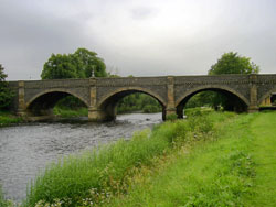
NSA
 |
| Tweed near Innerleithen |
Before more recent roads were made, the "ancient
road" from Ettrick Forest, Eskdale and Teviotdale
ran up the Leithen valley to Heriot Moor by a defile
called Dewar-Gill.
Peebles is the market town. In summer a one horse chaise
travels there daily and two coaches run to Edinburgh
each day. There are 10 miles of toll road down the Tweed
and another 9 miles up the Leithen. There is a daily
carriage in summer between Glasgow and Kelso.
Coal comes from the Lothians 16 miles away but a new
road up the Leithen will be opened next summer (1835)
and reduce the cost.
Kilbucho
OSA
Peat is used as coal is so distant.
Three tumuli at Kilbucho, Coulter and Lamington are three
miles apart and may have been signal stations.
NSA (now parish of Broughton, Glenholm
and Kilbucho - see above)
Kirkurd
OSA
The Edinburgh to Moffat and the recently made Peebles
to Glasgow roads pass through. They are in "tolerable"
repair.
The statute labour is commuted. Bridges are excellent.
NSA
The nearest markets are Biggar and Peebles. There
are very good communications as the Edinburgh to Dumfries
and Glasgow to Peebles roads run through the parish. There
are 7 or 8 miles of excellent turnpike and three main
bridges. There is one inn, used by travellers.
Coals can be obtained 6 miles away but better coal
is available from Douglas and Carnwath.
Linton
OSA;
also sheep
markets
 Mention
of the Cauldstane Slaup - a pass over the Pentlands. Mention
of the Cauldstane Slaup - a pass over the Pentlands.
Limestone is available at Carlops, Whitefield and Spittlehaugh;
coal at Carlops and Coalyburn.
Two large markets held at Linton with sheep being brought
in from surrounding parishes. They are taken to the Highlands
or the Ochils.
An Act for the Linton and Noblehouse roads from Edinburgh
to Moffat was made about 1756. These are maintained at
a cost of 50/- per mile, the rest of the money going to
pay off the debt. The statute labour is commuted at a
rate of 4d per day.
NSA
Sheep markets have been held here for many years. The
sheep used to be sent to the highlands but are now mostly
sent to Fife, Perth etc and to England.
Some of the farms here keep highland cattle bought at
Falkirk and Hallow Fair.
There are five carriers in the parish.
Approaching the village from the old road from Edinburgh
was very difficult but is much easier since a new road
was made last year.
 A
new road, 6 miles in length from Carlops to Ingratson
was built recently to the south of the old road. This
had been supported by the Lanark and Mid-Lothian trustees
but was much delayed by opposition from the Peebleshire
trustees. A
new road, 6 miles in length from Carlops to Ingratson
was built recently to the south of the old road. This
had been supported by the Lanark and Mid-Lothian trustees
but was much delayed by opposition from the Peebleshire
trustees.
Three miles of road have been made north of Linton to
Badensgill. Ideally this would continue over the Cauldstane
Slap to allow easy access to Falkirk, Stirling and Queensferry.
Agreement will, however, have to be reached with the gentlemen
on the north side of the "slap".
View from the Baddinsgill Road
United Parishes of Lyne and Meggat
Parish
map (Thomson's Atlas 1832)
OSA;
also Romans
etc
 |
| Lyne Kirk |
There is a Roman camp one mile west of Lyne - the road
running to it is still visible. In Meggat there are
two old towers - the Kings of Scotland used to hunt
in this area.
There are traces of 3 or 4 roads running across the
hills, though their age and purpose is not known.
Gold is to be found in Glengaber Water.
Lyne is not too far from coal and lime and the roads
are good with two useful bridges.
Meggat is 14 miles from the church and the road is "remarkably
bad and steep". In view of the nature of the road to
Meggat and the fact that it is cut off in winter, a
new road would be a great benefit. The present steep
pull could be avoided by taking it near to Manorhead
and then along Glengaber Water. Although expensive the
cost of the recent act of parliament to build roads
in the county would have been sufficient to have built
this particular road. It is hard on the poorer counties
to have to spend �400 to get permission to spend their
own money.
It is to be hoped that the benefits of roads will be
recognised - they have improved recently though further
progress is possible. To avoid self-interest, those
who plan the routes should be appointed from a neighbouring
county and there would be benefits in having commissioners
and engineers at a national level.
NSA
 |
| Megget. An old track led over
to the Manor Valley from here. |
A road leading to a Roman camp at Lyne is still visible.
There are two old towers up the Meggat from where signals
could probably be given of incursions from the south.
There are four miles of turnpike and a weekly carrier
between Hawick and Glasgow. For some years there has
been a daily coach betwen Glasgow and Kelso in the sumnmer.
There are two bridges between Lyne and Stobo, and one
over the Meggat.
Only peat is used in Meggat as coal is so expensive.
A little coal is used in Lyne and is obtained either
from mid-Lothian or the northern part of Newlands parish.
Manor
OSA
There is a Roman camp and an old watch tower in the parish.
Coal is 18 miles away - most people use peats.
NSA
 |
| Manor Valley |
p. 116 The Thief's Road, used in the past on border
raids, goes from Manorhead and Dollar Law to Scrape.
After crossing the Tweed below Stobo it heads for Lyne,
Newlands and Linton.
There is a chain of defensive towers along which signals
could be passed.
Peebles is the market town to which there is a good
parish road. There are four stone bridges in the parish.
Coal is brought from White-hill in mid-Lothian or Wilsontown
in Lanarkshire and is expensive because of the distance.
Newlands
Parish
map (Thomson's Atlas 1832)
 |
 |
| Romannobridge -
the road used to go through the village |
Old church at Newlands
- cultivation terraces on hill at left |
OSA;
see also
The roads here are covered by the same act as Linton
and the statute labour rates are the same.
There is an inn and two alehouses in Noblehouse. The
inn has post-chaises. Weekly carriers to Edinburgh.
There are two cadgers who sometimes buy eggs, poultry
and skins for Edinburgh. Nine of the local farmers carry
goods occasionally.
NSA
Dairy produce is sent to Edinburgh. The road to Peebles
is mentioned.
Peebles
OSA
; also towers
Two bridges over the river.
Much oatmeal brought through from the east side of the
country to the west.
Chain of towers which could send signals of incursions
by using smoke or fire.
The area was used for hunting by royalty being 20 miles
from Edinburgh, in good sporting country and on the route
to the King�s Forest of Ettrick. The bridge
may have been built by the king and the people for their
convenience. There was a toll on the bridge in 1560.
NSA
 |
| Tweed Bridge, Peebles |
Peebles was used as a base for hunting by the Scottish
Kings (until James VI became King of England). As a
result many members of court had residences here for
use during hunting.
A "hospitium"
was established at Eshiels farm for the elderly and
sick and to assist travellers.
With good materials to work with, Tweeddale roads are
very good. However, they are narrow and where they go
on steep slopes can be dangerous at night.
The age of the bridge in the town is unknown but seems
to have been built at different periods. As it is only
8 foot wide only one carriage at a time can cross but
next summer it is hoped to widen it under an Act of
Parliament. An iron bridge for foot-passengers was built
in an estate below Peebles about 16 years ago. The plan
for a rail-road between Berwick and Glasgow has been
abandoned.
Under James VI the town had the right to hold 9 fairs
each year. There are now four fairs.
Skirling
OSA
Four annual fairs.
Coal is 15 miles away - there is a moss in the parish
but it is nearly exhausted.
The roads are poor mainly because lead from Leadhills
and Wanlockhead passes through.
The statute labour is inadequate to keep the roads in
good order.
NSA
There are three miles of turnpike and 5 bridges. There
are other roads in all directions. Biggar, two miles away,
is the market town. Skirling has three fairs at which
cattle etc are sold. In the past there had been two other
fairs, one of which, for sheep and hogs, was moved to
Linton.
There are two inns. Coal comes from Douglas and Wilsontown,
14 miles away which adds to its cost.
Stobo
OSA
The Sherrifmuir is where the Tweedsmuir militia meet.
Coal is 18 miles away.
The high road is called the Stobo Hedges because of the
hedges that were planted along it some years ago. The
main road and the roads on either side of it are recent.
The statute labour is commuted. There is no turnpike.
There are two bridges over the Water of Lyne: one was
build recently by subscription; the other is old and very
useful for getting to Peebles. The newer bridge was built
as part of a road along the Water of Lyne that joins the
Peebles road on the east and the Kirkurd road on the west.
The road is completed and helps those coming from the
west.
There is also a bridge over the Biggar water which gives
good access to the Moffat road.
NSA
 |
| Rachan Mill |
The Tweed is about one and a half foot deep at the
fords.In times of border unrest, militia assembled on
Sherrifmuir.
Coal comes from Mid-Lothian, Douglas or Wilsontown.
There are weekly carriers to Peebles and Edinburgh.
The nearest post offices are at Peebles and Rachan Mill.
Of the two turnpikes here, one runs west beside the
Tweed for 4 miles, the other for 3 miles towards Kirkurd
and Newlands parishes. There are three good bridges
over the Lyne and one over Biggar Water on the bounds
of Broughton parish.
Traquair
OSA
 |
| Minchmoor
near Traquhair |
The old road to Selkirk runs over the Minchmoor.
The parish is distant from coal and lime and the roads
are poor. The commuted statute labour should be enough
to pay for improving the roads; a local toll bar has
been of no advantage to the parish.
If a route was formed through the parish between Edinburgh
and Carlisle it would shorten the distance by 27 miles.
A public-spirited person has offered to pay half the
cost of a bridge over the Tweed. This would be a great
advantage bringing coal and lime 14 miles nearer and
opening up a route to England.
NSA
Reference to the road over Minchmuir being used
in 1645.
The nearest market and post town is Peebles. There is
also a penny post from Innerleithen for parts of this
parish. Although there are 15 miles of turnpike in the
parish, the parish is not a thoroughfare and so no mail
or stage coaches run here. The turnpikes are much improved
and have good bridges. A timber bridge has been built
over the Tweed on the new road to Innerleithen and Edinburgh.
One road to Peebles follows the Tweed for about 12 miles;
another runs north-south along the Quair and a tributary
for three miles.
Coal comes from mid-Lothian and so is expensive although
costs will be less once a new road in the county of
Edinburgh meets the one made up the Leithen.
Tweedsmuir
OSA
 A
number of sheep are sent to the Linton markets. A
number of sheep are sent to the Linton markets.
The Edinburgh to Moffat road runs on the banks of the
Tweed. It is in bad condition but there are proposals
to have it repaired. There are inns at Crook, Beild and
Tweedshaws.
Near Tweed's Cross. The road has the turnpike line.
NSA
 |
 |
| Memorial
to the driver and guard of the mail coach |
The
Crook Inn - established c.1604 |
p. 62 A cross is said to have stood at Tweeds-cross
near the source of the Tweed and the county border.
Such crosses were common on public roads before the
Reformation and were probably used as "devotional
landmarks" to guide travellers.
Near here, the driver and guard of the mail coach were
caught in a severe snowstorm in 1821 and died when they
tried to continue the journey with the mail bags on
foot.
Mention of a road from the church to Menzion House and
of one towards the Beild Inn.
Biggar is the nearest market town and is 12 miles from
the Crook Inn. Post-chaises and horses are available
at the inn which also serves as a post office. The Edinburgh
to Moffat and Dumfries road runs for 10 miles through
the parish. A mail coach passes through each day. Three
inns are on the turnpikes and are used by travellers.
Coal comes from Douglas, 26 miles away. As it is expensive,
peat is often used in preference.
New Statistical Account: General Observations
Means of Communication
Top
|


