VOLUME
I
| The
Garioch, Aberdeenshire; 18 parishes in Aberdeen |
Description
of the Parishes in Angus |
| Country
of Buchan, Aberdeenshire; Notes for Banff &
Buchan; Aberdour; Pitsligo; Rathen; Strichen |
Dunfermline,
Auchtermuchty, Colessie, Abernethy, Colessie |
| New
& Old Deer; St Fergus,Banff; Crimond, Aberdeen;
Lonmay; Longside; Peterhead; Description of 9 parishes |
Markinch,
Beath, Monimaill; Newburgh; Clackmannan; Alva; Lecropt;
Dunblane |
| Daviot;
New Macar; Drumblade; Keith (Banff); Description
- Ochterlees, Turriff & Fyvies in Aberdeenshire |
Stirlingshire
- Morwenside; Slamannan; Falkirk; Bothkennar;
Airth; Larbert; Dunipace |
| Monymusk,
Kenmay & Cluny; Logie Buchan; Newhills; Kincardine
O'Neil, Aboyne/Glentanar; Banchory Devenock |
Perthshire
- Kilmadock; Kincardine; Pert; Aberfoyle. Buchanan;
Fintree; Kilmaronock; Bonhill |
| Perthshire
- Alyth; Abernethy; Dunning; Fargandenny; Rind &
Dron; Muthill; Callendar; Logie; Blackford, Ochterarder,
Dunning &c |
Selkirkshire;
Annandale |
| Orkney
& Caithness - St Olla & Kirkwall; Carnesby;
Wick; Latheron; Thurso; Bowar; Wattin; Reay |
Newbattle;
Gladsmure; Aberlady; Haddington; Ladykirk (Merse) |
| Strathnaver
- Farr; Durness; Creich
|
Gretna
& Reidkirk; Langholm; Ewes; Kirkpatrick
Durham; Minigaff |
| Inverness;
Suddie; Urray & Kilchrist (Ross); Alness (Ross)
Boleskin & Abertarf; Calder (Nairn); Spynie
(Moray); Alves (Elgin); Bellie (Banff); Banff; Alva
(Banff) |
Monktoun;
Stair; Symington. Bothwell. Inchinnan; Erskine |
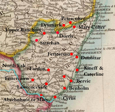
| Fettteresso;Kineff
& Caterline;Upper Banchory; Strachan; Durres;
Peter Coulter; Aberluthnot, Benholm, Cyris |
Ellon
& Logie Buchan; Strachan; Drumack; Durres;
Mary Culter |
| Dunotar,
Katerline & Kineff, Bervy, Fettercairn, Fordoun,
Lawrencekirk, Aberluthnot, Fordoun |
|

Note: The roads in yellow are from
Farquharson's
map of the Forest of Mar that dates from 1703. Those
in purple are from Herman
Moll's map of 1718 entitled "A pocket companion
of ye roads of ye North part of Great Britain called
Scotland." As it is very difficult to ascertain
the course of these roads from his map they should be
taken as illustrative only. Some roads from the texts
have been added in orange; again these should be taken
as illustrative only.
The Garioch, Aberdeenshire
1724
Page 4 King’s highway from Aberdeen to Inverness
runs through Culsalmon parish (also P16 - another highway
passes through here from the high country to Buchan).
Page 6 -ditto for Chappel of Garrioch parish (also P17
- the king’s highway from Aberdeen to the high
country passes through here).
Page 7 Fine bridge over Water of Don in Aberdeen.
Page 8 The king’s highway from Aberdeen to Inverness
runs through the town of Inverurie. The highway uses
fords and passage boats to cross the Don and Water of
Urie.
Page 11 The king’s highway from Aberdeen to Banff
runs through the parish and village of Old Meldrum.
Page 14 King’s highway from Edinburgh to Inverness
runs through Clatt parish.
Page 16 No highway in parish of Kinnemonth.
King’s highway from Aberdeen to the high country
passes through Premnay parish by Miln of Barns and Overhall.
Page 18 One of the Lesleys of Balquhoyn built a dyke
around the top of Bennochie and a long Causey across
a great moss up to the fort “whither he brought
such handsom Girles whom he fancied….”
Description of eighteen parishes in the shire and
diocese of Aberdeen C.1720
Page 21 Boat of Alford over the river Don in Strathdone
parish. The highway between Perth and Inverness passes
through here. There is a new bridge over the Don at
Pot of Pool d’oylie.
Page 24 In Coldstane and Logie parish there is a highway
between Aberdeen and the heights of Strathdone etc.
Page 26 A highway to Elgin runs through Cabrach parish.
Page 35 A highway between Edinburgh and Inverness runs
through Tullinessel parish.
Page 36 A highway between Edinburgh and Inverness runs
through Gartlie parish.
Page 37 Bridge of Peiduly near Strathdon kirk.
Description of Countrey of Buchan
Aberdeenshire 1721
Page 38 Stone bridge on the River Cruden in Cruden parish.
The bridge was erected by a bishop of Brechin.
Page 39 Bridge over Eugie in parish of St Fergus, near
to Peterhead.
Page 41 Bridge over water of Auchmedden between Aberdour
and Gemrie parishes. It was built by local gentry.
Page 42 Bridge in Turriff.
Notes for Banff & Buchan 1722
Page 46 Two pages of distances in Banff and Buchan (in
miles, half-miles and quarter-miles).
Description of the Parish of Aberdour 1724
Page 49 Bridge on the Burn of Glenquhitle in Aberdour
parish.
Page 50 King’s highway from Peterhead and Fraserburgh
to Banff passes through Aberdour.
Description of the Parish of Pitsligo 1723
Page 50 King’s highway between Fraserburgh and
Banff passes through Pitsligo.
Description of the Parish of Rathen1723
Page 55 Two wooden bridges over Water of Pilhorth in
parish of Rathen. One is ¼ mile west of the church
on the road to Old Dear and the other is between Carnbuilg
and the sea on the Frazerburgh to Peterhead road.
Description of the Parish of Strichen 1723
Page 60 There are three highways in the parish of Strichen.
One comes in from Pitsligo and goes to Old Deer, Ellon
and Aberdeen; another comes from Frazerburgh and goes
to New Deer and Turriff; and a third that passes between
Old Deer and Frazerburgh going by Rindrought. There
is a ford at Rindrought and a timber bridge for horse
and foot.
There are three bridges in the parish: Rindrought, as
said; Howfoord for those on foot only though there is
also a ford; and one just above the church with a nearby
ford. There is another ford near the church at the old
mill of Streechen on the way to Pitsligo and Aberdour.
Description of the Parish of New Deer 1723
Page 62 The king’s highway from Tarves to Fraserburgh
and that from Peterhead to Turreff pass through the
parish of New Deer. There are two stone bridges in the
parish.
Description of the Parish of
Old Deer 1723
Page 62 The king’s highways from Aberdeen to Fraserburgh
and from Strathbogie, Turreff etc to Peterhead intersect
in the parish of Old Deer. There are two great fairs
and a weekly market.
At the east side of the village there is a wooden bridge
and another wooden bridge over the Ugie nearby. A fine
stone bridge has been erected at the expense of a local
landowner, who had also built a small bridge near his
house at Bruxie.
Description Parish of St Fergus, Banffshire and Crimond,
Aberdeenshire 1722
Page 66 Bridge over Eugie at Inverugie in St Fergus
parish, also 2 fords close by. Bridge over water of
Anchie.
Page 67 Wooden bridge and ford in Crimond parish.
Description of the Parish of Lonmay, Aberdeenshire
1722
Page 68 In the parish of Lonmay, the king’s highway
goes from Inveralochie south past the church to the
Calsay of Kininmunth and then by a timber bridge over
the Water of Eugie to Old Deer.
Description of the Parish of Longside, Aberdeenshire
1723
Page 70 Two timber bridges over Water of Ugie in the
parish of Longside.
Description Parish of Peterhead 1733
Page 70 Good stone bridge in Peterhead.
Description of 9 Parishes 1724
Page 75 Bridge on the burn of Boyne in parish of Boyndy.
Cullen to Banff is 8 miles by the king’s highway.
Page 80 In Glass parish there is a stone bridge at
Strathbogie; also 1¼ miles SW of Glass church.
The king’s highway runs north-south and divides
the parish from Cairny; there is also a highway from
Aberdeen to the highlands.
A Geographical Description
of the Parish of Daviot
Page 84 Daviot parish has one highway which runs from
Inverury to Turreff.
A Short Account of the Parish of New Macar
Page 84 In New Macar parish the “Marcket Road”
from Aberdeen to Banff runs by Parkhill Kinmundy, the
church, Udny and Turriff.
Description Parish of Drumblade
Page 86 In the parish of Drumblade the public road goes
from Strathbogy to Aberdeen. There is also a highway
from Huntley to Turreff that passes through.
Keith Parish in Banffshire post-1742
Page 89 There is a bridge over the Yla near Keith church.
At Glengerach, two miles north and by east from the
church there is another bridge.
Description Parishes of Ochterless, Tureff and Fyvie
in Aberdeen 1723
Page 92 In Turriff parish there is a bridge over the
Turriff near the town.. The king’s highway from
Aberdeen to Banff passes through the town.
Page 94 In Fyvie parish there is a bridge over the
Ythan at Lewes of Fyvie, half a mile from the village.
A Geographical Description
of the Parishes of Monymusk Kenmay and Cluny 1722
Page 95 There is a small bridge in Monymusk. Mention
of Boat of Kemnay on the river Don and a Boat in Monymusk.
There are also 2 or three fords.
The highway from Aberdeen passes the church of Kenmay
and leads over the Bridge of Ton over the Ton Burn.
The Rectified Highway called the Skene Road from Aberdeen
enters Clunie parish to the SE, runs past Drumlahoy
to Mill of Clunie where there is a bridge, then through
Monymusk parish to the parishes of Touch and Keig.
Page 97 There is a ferry boat in Ellon.
Parish of Logie Buchan 1723
page 97 A ferry boat on the south side of the river
Ythan mentioned in account of Logie Buchan, also in
connection with Methlik parish (page98).
Description Parish of Newhills, Aberdenshire 1725
Page 99 The North Road passes through Newhills parish
and crosses the bridge of Buxburn. A public road runs
through Alford to the highlands.
Descriptions of Kincardine O’Neil, Aboyne and
Glentanar Parishes 1725
Page 101 Details of several roads are given, e.g. there
is a ferry boat over the Dee at Kincardine O’Neil
and there is a direct road between Aberdeen and Braemar.
The burn of Desk which divides Kincardine from Aboyne
is crossed by a “strong timber bridge with stone
land sleats.”
Road NE of Kincardine with a timber bridge over the
Burn of Canny. Road from Craigmyle towards Wester Billie
with “steps” over the Burn of Canny; road
northwards by the church at Tough etc
Banchory Devenock in Aberdeen and Merns 1725
P 107 Banchory Devenock church is one mile from the
Bridge of Dee leading to Aberdeen close by. Parishoners
pay for a ferry boat to take them across the river on
the Sabbath.
“To the north of Auchorties 1½ mile is the
Caulsay port with a large Caulsay which pass throw a
large moss and the port was built and the Caulsay laid
1684 by the City of Aberdeen and the said town setts
in tack the said port to a man who gathers up from every
horse that passes throw the port eight pennies Scots.
At the north end of the said Caulsay passes throw the
Grampian hills which goe straight to the sea, and there
is a large highway passes from Aberdeen to Edinburgh
along this Caulsay.” - see also Causey
Mounth
Highway from Aberdeen to the Highlands on the north
side of the river.
See also 1) Ellon
& Logie Buchan; 2) Balvenie,
Keith, Kintore, Aberdeen, Kincardine, Strathbogie, Aberdeen;
Aberdeen
Geographical Descriptions of
Severall Parishes in Perthshire.

Alyth 1727
Page 109 Alyth is connected by king’s highways
to Forfar by the bridge of Ruthven; Dundee by Meigle,
Newtyld and Auchterhouse; Perth by Coupar of Angus;
and Dunkeld by Blairgowrie and Clunie.
P 110 There is a passage boat over the Yla on the way
from Alyth to Meigle, and one over the same river on
the way to Couper in Angus (p111).
P 113 There are five stone bridges on the Alyth Burn:
one at Tilliemurdoch, two in Alyth, one about a mile
below Alyth and one at the Castle of Innerqueich.
Abernethy 1722
P 115 In Abernethy parish there are boats for foot passengers
and horses over both the Arne (Earn) and Tay, near their
confluence at a place called the Heughhead.
It is five miles to Perth by the king’s highway,
which crosses over the Bridge
of Erne (NMRS record-see also Images Online. The
bridge dates from c.1329 - very little remains today).
King’s highways also go to Stirling, Perth by the
Kingoren “rod”, Falkland, Kirkcaldy, Couper
by Newburgh. There is a public way from Kingoren to
the Carse of Gowrie and Angus, and a foot passage on
the Caree. At Gaule there is a bridge and two fords.
Dunning 1723
Page 119 In Dunning parish, the king’s highway
from the west of Scotland through Stirling to the East-Bridge
of Earn runs through, as does the way to Fife and the
“several passages by boat over the Forth.”
There is a bridge in the south east of the parish, and
a boat at Innerdunning over the Earn. Two miles NW of
Dunning there is the Dalreoch Boat “on a very public
way.”
Forgandenny 1727
Page 125 In Forgandenny parish highways run east-west
and north-south (Perth to Kinross).
Rind and Dron 1723
Page 126 There are three ferries in Rind parish: one
for those on foot comes from Carie in Abernethy parish,
two others which also take horses are from the heughhead
in Abernethy parish and from the Carse of Gowrie - this
one leads to the Bridge of Earn.
Page 127 Two roads pass through Dron parish. One runs
south from Perth over the Bridge of Earn and goes to
Kingorn; the other runs from Abernethy over to the Stirling
road. Where the first road runs through here it is known
as the Peth of Drone - “yea it goes through the
midel of the Paroch up the Peth of Drone which peth
is a highway through that chain of hills which lyes
along the south side of the river of Arne….”
Muthill
Page 131 In Muthill parish there is a bridge with four
arches over the Earn. One of the arches was destroyed
by the rebels in 1715 to stop the Duke of Argyle’s
march to Perth.
There are passage boats at Dallpatrick and Enerpafry,
and two bridges over the Mahany. The one at the mill
of Steps has “stone pillars laid over with oak
trees and covered above with gravel.” There is
another bridge over the Knaijk near Ardoch on the road
to Stirling.
The road from Stirling to Crieff runs through here as
does one from Auchterarder to Comrie, Balwider and Innerlochie.
There is another road which goes from Muthill to Perth,
“which is called the street way because it runs
in a straight line for the most part, and is cassied
with stone, this way is said to have once run betwixt
Perth and Sterling which is about 24 miles, and is said
to be done either by the Picts or the Romans.”
A Description of the Parish of Callender 1723
Page 134 In Callender parish there is a ford over the
Teith near the church and a boat a little to the east.
The water of Keltie has a bridge and a ford near where
it joins the Teith. At the Chapell of Little Lenie over
the Garvusk there is a “good tuimber bridge with
stone and lime work in the water.” The river can
be forded above and below this bridge.
The king’s highway (from Edinburgh to Fort William)
runs from the bridge of Keltie by the kirktoun and Kilmahoy
towards Balquidder parish.
Logie Parish 1724
Page 136 In Logie parish there is a highway from Stirling
to Alloa which goes by Tillibodie bridge, and one form
Stirling to Alva, Tillicultry, Doler, Castle Campble
etc that runs along the foot of the Ochils.
Some Short Notes on the Parishes of Blackford, Ochterarder,
Dunning etc in Perthshire 1725
Page 138 Crieff parish - mention of a bridge over the
Earn in Crieff.
Page 140 In Madderty parish there is a bridge over
the Pow at Dolarie and boats for horses and men on the
Earn.
Go to other Perthshire
parishes (Kilmadock, Kincardine, Port of Menteith,
Aberfoyle); see also Abernethy;
and Lecropt &
Dunblane
Description of St Olla Parish
and Kirkwall 1726
Page 142 There is a bridge between Scalpa and Kirkwall.
Kirkwall has one street.
Page 147 Mention of a bridge in Kirkwall.
Geographical Description of the Parish of Cannesbay
post-1724
 Page
153 “The ferry to Orkney is sited near John a Grott’s
House. The fare to Barwich on South Ronaldsay is forty
pence but double that or four pound Scots on the passage
or horse boat.” Page
153 “The ferry to Orkney is sited near John a Grott’s
House. The fare to Barwich on South Ronaldsay is forty
pence but double that or four pound Scots on the passage
or horse boat.”
Page 154 “The parish lying in a canton, has no
highways except what leads from all quarters to the
church, and the roads everywhere so bad, that there
is scarce any travelling betwixt any two towns in the
parish by horse except by bridges made of turff and
heath, which must be changed once in the two or three
years when the soft mossy ground being cutt by the feet
of cattell becomes impassable; such bridges we have
in store, frequently 30, 40 or 50 of them in less half
a mile of way and some good large ones too. One particularly
that ¼ mile long and called the Long Bridge.”
Geographical Description of the Parish of Wick 1726
Page 161 “There is a Bridge at the toun of Wick
for the conveniency of the Parish of eleven pillars
built with loose stones and only timber laid over them,
they are maintained by the southside of the parish for
carrying them to the church.”
Geographical Description
of the Parish of Lathron 1720’s
Page 163 Bridge erected this year over burn of Lethronwheel.
Three furlongs south of Lethronwheel House there is
a “great fabrick” with a causeway - it is
said that the causeway “was to be carried on to
the town of Thurso, which will be about 17 miles from
it, that part, which was made in the Causway mire (which
is as bad road as in the countrey, and the road by which
the minister of the Parish must go to attend the meetings
of the Presbytry) is obvious to any who travel that
way.”
Note: The “great fabrick”
appears to be the remains of a castle - see NMRS
record ) The Causway myre is shown on Robert
Gordon’s map of Caithness dated 1642, and appears
also on Blaeu as very faint lines. As Gordon is thought
to have had sight of Pont’s drafts there is every
likelihood that the causeway existed in the 1590’s.
It is not clear what its purpose was, although it seems
to have headed for Thurso which as a settlement dates
back to at least the early middle ages when it was an
important Norse port. There is a tradition that Cromwellian
troops worked on it in the early 1650’s and Sir
John Sinclair had work done on the causeway in the 1770’s
using statute labour but the causeway existed before
both these endeavours - see George Watson, Roads
and Tracks through Local History (Caithness Community
Website) for details.
Page 165 There are two chapels on opposite sides of
the water of Berridale with a road between them that
crosses the great hill of Scarbine, “which rod
is called by the natives la cois nive i.e. the
rod where the ………. travel.” (see
part
3 on above site)
Page 167 The boundary with Sutherland is at the hill
of the Ord. On the south side of the hill is the “common
passage to and from this country”. The road appeared
very dangerous but Sir James Sinclair of Dunbeath had
made improvements. From here to the church of Latheron
(9 large miles) the road was very bad.
Description Thurso Parish 1726
Page 171 There is a post office to Inverness. There
is a ford and a ferry boat over the river.
Page 172 At Scrabster there is a small stone bridge
built fairly recently over a small burn.
Description Parish of Bowar
Page 178 The king’s highway between Wick and Thurso
passes through by Brabster-dorren and Northfield.
Description Parish of Wattin 1726
Page 180 The king’s highway between Wick and Thurso
passes the church.
Description Parish of Reay 1726
Page 181 There is a bridge over the Sandside. There
is another bridge ¼ mile east of the church (p183).
Page 183 “The King’s high road from the parish
of Kildonan to the church of Reay is thro’ Binvallich
down the river of Halladale and over Drimhollistill.”
Page 184 “The King’s high road from Reay to
Thurso is thro Isauld Dunray, north side of Skiall and
by the Bridge of Forse.”
Country of Strathnaver
containing the parishes of Farr, Toungue, Durness, Ederachillis
and part of Reay, Sutherland 1726
 Farr Farr
Page 188 South from Loch Naver the river of Bagisty
“lyes in the road between Sutherland and Strathnaver
and is very troublesome when high the passengers that
ride, being obliged to cross it upwards of four and
twenty times in the space of three or four miles, and
all the adjacent ground is boggy and full of stanks.”
Durness
Page 191 The parish is separated from Tongue by boggy
ground which is “scarce ridable but either in a
very dry summer or in hard winter frost and not then
without a good guide having many small loches and quagmires
through it.”
A Geographical Description of the Parish of Creich,
Sutherland 1725
Page 202 None of the rivers in this parish have bridges
or boats.
Page 203 “The way is generally bad, there are several
mosses, boges, and steep rocks and hills, which as well
as the rivulets would be tedious, and an endless labour
to describe.”
City of Inverness 1732
Page 205 Mention of the coach road leading to the south
recently made by General Wade. Bridge in the town and
Ferry of Kessack.

Suddie, Inverness-shire 1732
Page 207 Highway to Chanonry.
Memorandum about the United Paroches of Urray &
Kilchrist, Ross-shire 1725
Page 210 Ferry boat on the River of Connon. There is
another ferry on the same river to the west called the
ferry boat of Moy.
The Orran is easily forded - 1½ miles SW of the
kirk there is a timber bridge. There is a similar wooden
bridge over the Goury near the confluence with the Orran.
Geographical Description of Alness Parish, Rossshire
Page 212 Bridge over the Alness ½ mile NE of
the church.
United Parish of Boleskin & Abertarf or Killchumin
Page 220 The Fechlin is a very rapid stream that runs
into Loch Ness - many have drowned in it and it has
impeded the “march and stages” of the King’s
troops and other passengers. Near to the river there
is “good conveniency” for travellers at Dringhempte
- it is 18 miles from Inverness and 6 from Killchumin
or the barracks there. The Garry is seldom fordable
in the winter months yet has no bridge or ferry - -
it is near the barracks.
A Geographicall Description of Calder Parish (Cawdor),
Nairnshire 1726
Page 226 The river Nairn has a bridge in the town and
one six miles above at the Bridge of Cantra.
Page 228 The Findhorn is crossed by the Bridge of Dulassie,
12 miles from the sea.
Page 229 The writer notes that the separate parts of
Nairnshire went back to the time of the Thanes of Calder
(Cawdor) who were heritable sherrifs of Nairn when they
had jurisdiction over all lands belonging to them.

Description Parish of Spynie, Morayshire 1723
Page 230 Details of the ferries on the River Spey, viz.
boats of Budge, Fiddigh, Skirdustan or Aberlour, Delnapot,
Cromdell.
Page 231 King’s highway leading from Spey to Elgin.
Alves, Elginshire
Page 236 King’s highway runs through parish between
Elgin and Forres.
Bellie, Banffshire
Page 241 “Through this town passes the Kings High
Court way on the end of the town W.ward runs the river
Spey, where there are fine passage boats.”
The Parish of Banff
Page 243 There is a bridge over the Deveron at Huntly
Castle 12 miles south of Banff, and four ferry boats
in Banff itself with two fords.
Alva, Banffshire
Page 245 The Deveron is fordable at several places here
and there are boats at Auchinbady and Dunlugas.
 Description
Parish of Fetteresso (Kincardineshire) Page 247
The Edinburgh to Aberdeen road runs the length of the
parish. Description
Parish of Fetteresso (Kincardineshire) Page 247
The Edinburgh to Aberdeen road runs the length of the
parish.
A Geographical Description of the Parish of Kinneff
& Caterline, Kincardineshire
Page258 The King’s highway from Montrose to Aberdeen
passes through - see also 266 below.
Description Upper Banchory, Doors and Strachan in
Merns with notes of Mary Culter etc 1724
Upper Banchory (Banchory Terman/Banchory
Trinity)
Page 259 Two passage boats near Banchory.
Strachan
Page 260 Public highway runs over Carne of Month and
has stone bridges on it, over the Dee, three miles SW
of the church at Spittleburn. There are also bridges
on the Feuch and Burn of Camie.
Durres
Page 261 Within a mile from the church there are two
passage boats over the Dee on a public road that passes
over the Cryncross-Mouth. There are three bridges south
west of the church within 1½ miles.
Peter Coulter
Page 262 Bridge over burn of Kinnerty.
Description of Aberluthnet Parish, Benholm, Garvok,
Cyris, Glenbervie in Merns, Edzel in Angus 1724
Aberluthnet or Mary parish (Marykirk parish)
Page 262 Bridges over North Esk and other streams -
see also 268 below.
Benholm
Page 263 Highway runs north-south with bridges over
streams.
Cyris
Page 264 Mention of North Esk bridge and passage boat
on this river. Mention of highway.
Description of the Parishes
of Dunotar, Katerline and Kineff, Bervie, Arbuthnot
in Merns 1724
Dunnotar
Page 265 Highway goes close to Bridgeford towards Stonehaven.
Katerline & Kinneff
Page 266 (see also 258 above) “Highway betwixt
N.water bridge to the North parts goes ½ mile
North of Bridgefoord.”
Bervy
Page 266 Handsome stone bridge.
Description of the Parishes of Fettercairn, Fordun,
St Laurence and Mary Parish in Merns 1725
Fettercairn
Page 267 Mention of “Northesque water bridge”,
and another bridge.
Fordoun
Page 267 Bridge near Auchenblay and near Fordun.
Conveth or Lawrencekirk
Page 268 The village is three miles north of “north
water bridge”, Timber bridge at Phesdou and stone
bridge at Bridge of Lepit on the Kings highway between
Lawrencekirk and Stonehaven. - see also page 270.
Mary or Aberluthnot
Page 268 (see also p 262) Mention of bridges, viz. “North
water bridge”, bridge over the Luther and bridge
below Englishmadie.
Fordun
Page 269 Bridges at Auchenblay and near Fordun.
see also Strachan,
Drumoak, Durres, Mary Culter
Description of the Parishes
in Angus 1743
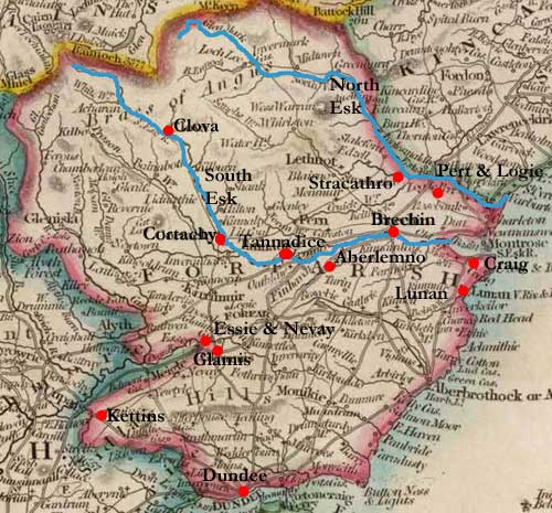 Craig Craig
Page 273 Village of Ferrydon on South Esk opposite Montrose
- passage boat.
Brechin
Page 273 Bridge over South Esk.
Strickathrow
Page 274 Mention of northwater bridge (North Water of
Esk).
Pert
Page 274 Church is 1/4mile from Northesk river bridge
- this was built by Erskine of Dun who maintains it
and in return receives customs from it.
Logie
Page 274 Mention of Northwater bridge.
Aberlemnay
Page 275 On highway between Forfar and Brechin.
Lunan
Page 276 Ford near House of Lunan.
Description of the Parishes of Eassie & Nevay
Page 277 Bridge of Cookstoun over the River of Dean.
Page 278 The Kings highway from Perth to Brechin goes
by Newmiln, Castletown and Eassie. A higher road often
taken by carriers between these two places goes by “Templetoun,
Balkerie and the Chappel in the said parishes.”
Description of the Paroch of Kettins
Page 280 “A very patent road from the Burgh of
Dundie, lies through this village to Coupar Angus, and
thence to Dunkel and Strathardle, and another from Perth,
by the foot of the said hills (Sidlaws) Eastward to
Glamis and Forfar.”
Description of the Paroches of Cortachie, and Clova,
Angus 1743
Page 283 There is a stone bridge over the south Esk
near the church in Cortachie.
Description of the Parochine of Tannadice, Angus
1744
Page 285 There is a passage boat over the Southesk,
¼ mile SE from the church and two others to the
west as well as the North Bridge of Cortachie.
Page 287 There is a bridge over the Noran called the
Courtfoord Bridge.
see also Glamis,
Dundee, Brechin, Pert
 Description
of the Parish of Dunfermline in the Shire of Fife 1744 Description
of the Parish of Dunfermline in the Shire of Fife 1744
Page 292 A list of distances to towns like Stirling,
Alloa, Coupar, Kircaldy etc are given and this probably
indicates the existence of roads to these places.
Mention of the North Ferry.
A Short Geographical Description of the Parishes
of Auchtermuchty and Collessie 1722
Page 295 The Kings highway from Cupar goes almost straight
to the eastwards. South of the town there is a bridge
over the Barroway water.
Page 296 There is an upland area to the NW (“a
great congeries of hills”) through which the kings
highway to Perth runs.
Additions to the Parishes
of Abernethy and Colessie 1722
Page 297 These appear to be questions arising from the
previous accounts. Under Abernethy the question is asked
How lyes Abernethy from Perth, and Faulkland? Whereabouts
is the bridge with 3 arches over water of Farge? The
answer given is:
 “Remember
as I told you before that the ancient toun of Abernithie,
it lys 5 miles Southest from Perth and 5 miles from
Falkland; the Brige of Gavile with 3 arches is on the
water of Farge a mile and a half northwest from Abernathie
upon the highway betwixt Falkland and Perth on the west
border of Abernathie parioch in that quarter, Likeways
the ferre passage that goes over the River of Tay, its
proper landing place is on the ground of Carne they
call the Hamlot Carne, where they land on the north
side of the river of Tay. Also that same ferrie crosses
over the river of Arne and its landing is on the ground
of Ester Rind Likewise the other ferrie, called Care
or Care bot its landing is on the ground of wester rind,
is upon the river of Arne. There is no passage of bots
but upon the Abernethie side. There is likewise one
ferrie passage on the est side of the Rind paroch but
the botes belongs to the eastside of the river Tay they
call the passage Inchu or Inchures but their landing
on the Rind paroch is on the ground of Elchu: likewise
the house of Elchue stands upon Tay side about 3 miles
south est from Pearth. “Remember
as I told you before that the ancient toun of Abernithie,
it lys 5 miles Southest from Perth and 5 miles from
Falkland; the Brige of Gavile with 3 arches is on the
water of Farge a mile and a half northwest from Abernathie
upon the highway betwixt Falkland and Perth on the west
border of Abernathie parioch in that quarter, Likeways
the ferre passage that goes over the River of Tay, its
proper landing place is on the ground of Carne they
call the Hamlot Carne, where they land on the north
side of the river of Tay. Also that same ferrie crosses
over the river of Arne and its landing is on the ground
of Ester Rind Likewise the other ferrie, called Care
or Care bot its landing is on the ground of wester rind,
is upon the river of Arne. There is no passage of bots
but upon the Abernethie side. There is likewise one
ferrie passage on the est side of the Rind paroch but
the botes belongs to the eastside of the river Tay they
call the passage Inchu or Inchures but their landing
on the Rind paroch is on the ground of Elchu: likewise
the house of Elchue stands upon Tay side about 3 miles
south est from Pearth.
N.B. the passage of the hughhed a mile North from Abernathie
is for both foot and horse and it goes over both Tay
and Arne. Its landing on the north side of Tay is on
the ground of Carne. Likewise its landing on the north
side of Arne is on the ground of Ester Rind. Als there
is ane other passage about half a mile North west from
Abernathie, only for foot called Care, which goes onely
over the river of Arne and lands on West Rind.”
Note: Map based on 1913 half-inch
OS map for Dundee, Perth & Stirling. With thanks
to Ordnance Survey.
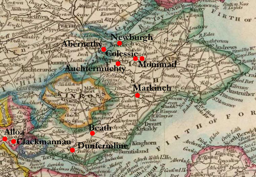
Description of Markinch,
Fife 1725
Page 300 On the road north from Kirkcaldy to Falkland,
we pass the bridge of Orc, then a mile further on, the
bridge of Lochtie, then a bridge built by the shire
over the Leven. The road enters Falkland parish at Paddockhall
ford where it splits into three branches: east to Cupar,
north to Newburgh, and west to Falkland and then Perth.
Another road leads from Kirkcaldy to Kennoway by Pathhead,
Dysart, Galla Town and Camron Bridge over the Leven.
There is also an east-west road that runs west from
Leven on the north side of the river. In this parish
it divides with one branch going to Leslie and the other
to this village to join the first road.
Finally there is a north-south road between Markinch
and Weems that crosses two bridges: one called Shethrum
bridge on the Leven and another called New Bridge just
after the confluence of the Orc and the Lochtie.
Description of Beath Parish, Fifeshire 1724
Page 302 Bridges at Lochburn and Kelty - the king’s
highway from Edinburgh to Perth passes through.
Description of the Parish of Monimaill, Fife 1723
Page 303 Roads between Coupar and Perth, the Southferry
and waterside of Dundee.
A Short Description of the Parish of Newburgh, Fife
1722
Page 304 King’s highway between St Andrews and
Coupar to Perth runs through the town. There are ferry
boats on the Tay at Erroll. Road between Newburgh and
Pitcarlie.
Parishes of Clackmannan, Tulliallan and Alloa 1722
Clackmannan
Page 306 “The King’s highway from Edinburgh
comes buy Queensferry and Toriburn to Clackmannan.”
Alloa 1722
Page 309 Mention of Rumbling Bridge and Bridge of Tulibody.
Description of the Parish
of Lecropt, Perth/Stirlingshire 1723
Page 310 The King’s highway divides after the Bridge
of Allan, one branch leading from Dunblane to Strathearn
and Perth, the other to Monteith and the west Highlands.
Description of Dunblane Parish
Page 311 Number of bridges mentioned. Highways from
Kilbride to Dunblane and Stirling, Stirling to Perth,
and to Crieff and the North Highlands. At Ardoch the
“neather“ bridge consists of four land stales
of stone covered with planks of oak and flags of stone;
at Kinbuck there is a similar bridge with five land
stalls and covered with timber and flags.
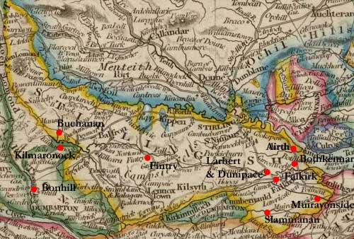 Morwenside,
Slamanna, Falkirk, Bothkennar, Airth, Larbert, Dunipace
in Stirlingshire 1723 Morwenside,
Slamanna, Falkirk, Bothkennar, Airth, Larbert, Dunipace
in Stirlingshire 1723
Morwenside (Muiravonside)
Page 316 Mention of Linlithgow Bridge. Muir road between
Linlithgow and Glasgow - this runs through Dalquhairn
(Avonbridge) and is used to drive cattle from the Falkirk
markets to England. Two bridges on Parkhall Burn: one
near the kirk, the other called Manuel Burn bridge.
High road from Falkirk to Bo’ness with a ford;
there are three bridges over this river - at St Laurence
Kirk (Slamannan), Dalquhairn (Avonbridge), and Linlithgow
Bridge. There is also a ferry at Bearcrofts.
The King’s high road from Linlithgow to Falkirk
passes through the parish.
Slamannan
Bridges as above - the Muir Road runs to the south side
of two lochs. There is another bridge over Castlehill
burn near the kirk.
Falkirk
There is a bridge over the Reidburn on the Muir road
from Falkirk to Glasgow, near to Cumbernauld. The village
is on the Glasgow to Edinburgh road (via Linlithgow).
At Camelon "there is to be found vaults, causieways
and Roman coins." Bridge at Parkend on the Linlithgow
road.
Four bridges on the Mumeral Burn. Mention of road to
Slamannan. Bridges over the West and East Burns and
a ford on the road to Airth at Stenhouse Damhead.
The road westwards divides at Tophilburn for Glasgow
and Stirling, and the Glasgow road itself divides a
bit further on at Boogton Crosshead where there is a
branch to Denny & Dunipace. There are several bridges
in the area.
At Bonnyhouse the deal road and muir roads to Glasgow
divide (note: John G Harrison: Improving
the roads and bridges of the Stirling area c 1660-1706,
PSAS, Vol 135 (2005), pps 287-307 suggests that deal
is dale or valley road).
Bothkennar
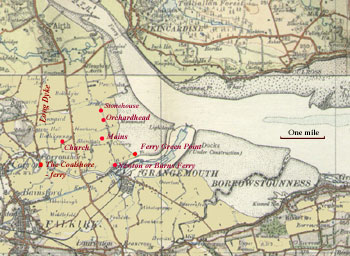 The
entry is interesting enough to reproduce in full: The
entry is interesting enough to reproduce in full:
“The publick roads, abstracting these to the Kirk,
which for the most pairt every one has from his house,
are one from Bo:ness or Linlithgow thro the Kerses and
passes Carron at the forsaid ferry (Newtons or Burns
ferry to Airth) either by boat when the tide is in,
or by horse, when the sea is out, and then by the road
at the Mains to Airth or from the forsaid ferry north
by Orcharthead and Stonehouses greens to Higgins Neuck.
There is a foot road from Bo:ness thro the Kerses to
Airth, which passes at a ferry below Newton called the
Grange Pow mounth or ferry green point. The passages
from Falkirk to Bothkenner are either by the ferry at
the coal shore which is in the parish of Larbert, and
a quarter of a mile southwest from Bothkenner kirk,
or by the Newtons or Burns ferry, or to ride at low
water at the Backerowford. This is a short quarter of
a mile South of the Kirk; that a large half mile south
southeast of the Kirk.”
There are three large bridges over the Carron, viz.
Carronbridge, Dennybridge and Larbert bridge on the
Stirling road. There are fords at Dorroter, Larbert,
Dunipace, Denny, Gennershaw etc. There is a harbour
at Greenbrae where coal is loaded.
Bridge near Pocknave mill called the running furrow
bridge.
Note: Map based on 1913 half-inch
OS map for Edinburgh & Lanark. With thanks to Ordnance
Survey.
Airth
Ferry over the Forth at Higgin’s Neuk.
There are four bridges on the South Pow: on the Falkirk
to Stirling road; Abbytown bridge on the Airth to Falkirk
road; the Milnbridge at the mill, and the Newmills bridge.
“The publick road from Higgons Neuck is either
by the Newmill bridge and so to Airth, or thro’
the Halls of Airth, and so on to the Moss Land or along
the Long Dyke.”
Larbert
Mention of the running furrow bridge and the coal road
to the shore.
There is a bridge in the village and a nearby ford.
“Two miles North east from Larbert upon the edge
of the Kerss, stands the house of Quarrell and upon
the west side of the foot road from Falkirk to Airth,
either when they pass at the west boat called Blacks
boat, which is a little below Stenhouse dame head upon
Carron, or when they cross at the foreshore: both roads
meets at the foot of Quarrell yeards: from thence is
a fine road to Airth either by horse or foot called
the Long Dyke.”
The road called the Mossband is a horse road from Falkirk
to Airth. On the north side of Carron at the “coal
shore” there is a ferry from Falkirk to Airth.
Boats call in near here for coal.
The Glasgow road from Airth passes to the north of Larbert
then to Dunnipace and Bonnybridge road where it joins
the Falkirk to Glasgow road.
Dunipace
Mention of the Airth to Glasgow road and bridges at
Larbert, Bonnybridge and Dennybridge.
See also Buchanan
and Fintry
Description of Six parishes
in Perthshire 1724
Kilmadock
Page 338 Bridge over the Teath near confluence with
Ardoch Water.
Kincardine
Page 339 Ferries on the Forth at Dripp, Badd, Killbeg
and Frew which also has a ford. Half a mile above Frew
is a stone bridge over the Goodie.
Port (of Menteith)
Page 341 Ford and ferry at Gartartan.
There is a tradition that Moss Flanders was once under
water - in proof of this there is a stone with a hole
in it where there was an iron ring to which boats could
be attached. It is called Clachnan Loang or the ship
or boat stone and is sited at the hill of Gartmore.
Aberfoyle
Page 342 Bridge beside the church - this was destroyed
by order of the government in 1715 but has not yet been
repaired.
Description of Kippen, Buchanan,
Drymenn, Balfron, Fintree and Gargunnock in Stirlingshire.
1724
Buchanan
Page 346 There is a ferry on Loch Lomond at Rowardennan.
A local tradition avers that the old loch was restricted
to the narrow section above Rowardennan and that the
wider part of the loch had once been land. In times
of drought boatmen are said to have seen ruins of houses
under the water. (note: the Statistical Accounts of
the area refer to stepping stones at the head of the
loch now being 5 or 6 feet under water).
Fintree
Page 350 Bridge near Culcreuch, and another between
Killearn and Drymen parishes. At Catter just south of
Drymen church there is a ford and a ferry boat and another
ferry boat at Cullnamune, near Buchanan church.
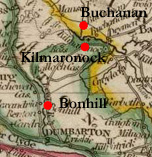 Kilmaronock Kilmaronock
Page 353 Ferry boat on Enrick.
Bonhill
Page 354 The Leven is fordable only in times of great
drought. There are ferry boats at Bonhill and at Balloch.
An Account of the Remarkable
Places and Paroch Churches in the Shire of Selkirk 1722
Page 355 Selkirk: There is a boat over the water of
Ettrick.
Mention of the King’s high street that goes to
the south borders.
Page 358 Bridge of Ettrick.
Page 359 Fine bridge at Yarrow.
Page 361 “Below the foot of Etricke the ¼
pairt of a myle or therby is two boats both for foot,
horse and packs crossing the river of Tweed at a place
called Baldsyd which toun and boats belongs to Scot
of Galla; thir boats being of great use for passage
from the south borders to Edr.”
Page 362 Two highways lead from Selkirk to Kelso.
Page 363 On Kershope hill “is a cross called Taitts
cross where is to be seen boughted and milked upwards
of twelve thousand ewes in the month of June about eight
a clock at night at one view.”
“Selkirk is the onlie road from the south borders
to Edr. Not the only but the ordinary.” (note:
some distances between border towns are given that probably
imply routes).
Description of Annandale 1723
Page 365 Several pages listing distances between places
are given, some of which are likely to relate to roads
but others like gentlemen’s seats only giving their
position relative to a town.
Reference to the Roman road on page 372 - “ To
the North of Woodhouse about a quarter of a mile on
the high road or Barras gate (which is very remarkable
for being the Roman military way and goes from the Borders
even to the West seas, pairts of which are yet very
firm especially at Gratney and Wamphray)…..”
 Description
Parish of Newbottle, Midlothian 1722 Description
Parish of Newbottle, Midlothian 1722
Page 373 Mention of bridge of Newbotle and the Maiden
Bridge.
An Account of the Paroche of Gladsmure, East Lothian
1723
Page 374 The King’s highway between Edinburgh and
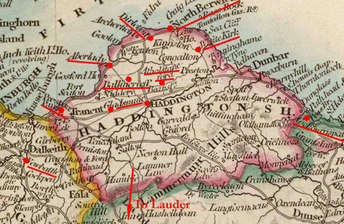
Haddington passes through the parish.
Description of Aberlady Paroch, East Lothian 1723
Page 374 The King’s highway from Edinburgh to Athelstonfoord,
Dirletown and Whitekirk passes through the village of
Ballencrief.
Page 375 There is also a King’s highway runs through
Aberlady from Edinburgh and Preston Pans to Dirletoun
and N Berwick.
Haddington Parish, East Lothian 1726
Page 375 There is a road 40 foot broad running to the
port of Aberlady. Mention of the bridge and a bridge
leading to the ruined abbey.
The town is on the post road “12 miles from Edinburgh
8 from Dunbar 14 from Cockburns strath 12 from Lauder
and 28 from Berwick.”
see also Edinburgh;
Haddington;
E & W Lothian
Geographical Desciption of Lady(kirk) Parish in
the Merse 1725
Page 380 There is a ferry boat called Bates boat much
used to bring coal in from Northumberland. There are
also four fords.
Description of the United Parishes
of Graitney & Reidkirk post-1710
Page 383 There are four fords over the Kirtle: Longrigs;
Milnflat West; Reidkirk Miln; old miln of Graitney.
The Sark has seven fords: Reburnfoot; Goldieslee; Atchisons
bank; Newtoun; Barroweslacks; Alisonebank; Lambfoord.
Page 385 Barrows gate (Roman road).
Page 387 The barrow gate is the road to Edinburgh and
Glasgow as well as England. There is another King’s
high road that runs from Dumfries through Annan to join
the Barrow gate - “all the Kings high ways from
England to Scotland and from Scotland to England joyne
there except roads of Courtesie.”
Description. Parish of Langholm 1726
Page 389 When Langholm was built in 1629 it was required
that the street between the houses should be at least
30 foot wide.
Trade with Carlisle, Annan, Dumfires and Hawick to all
of which there must have been routes.
Page 590 Bridges over the Ewes, Vachop and Tarras.
“There is a noble stone bridge of 3 arches over
the Esk about a mile below the church, 2 of them very
large about 44 foot diameter built about 26 years agoe.
A boat used in former times to goe at Langholm toun,
still called the boat ford, now there’s no use
for it.”
Description of the Parish of Ewis
Page 394 Tradition that monks from Melrose or Jedburgh
would come here to baptise and conduct marriages in
this parish.
Kilpatrick Durham
Page 395 Mention of the bridge of Urr and of the Edinburgh
road
Page 397 “The way from Edinburgh to Kirkcudbright
comes by Penpont, Glencairn, then Gairistoun (about
two miles and a half north of Mule.) then to the Mule
through gate betwixt Mule and Margloly in Irongray thence
south through Kilpatrick Mure called the Galagate thence
to the church. thence to bridge of Urr, to Carlingwork
&c.
From Dumfries to New Galloway ther is a way by Shawhead,
Lochinkit, Knock’droket in Nether Bar near Crogo
Trowhern &c.
The droves of cattle coming from New Galloway to England
come by Trowhen, Knockdoket then a little north of Lochinkit
till they come to Gal’gate and then follow it southward
till within about half a mile of Easter Marwhin, and
so on to Larg and then to Dunfries &c.
The best way but somewhat longer from Dumfreis to New
Galloway is by Lochruttongate near the church, Miltoun
of Urr, Kilpatrick church. Kilwhamedy. Parton Shirmers
New Galloway.
From Dumfries to Kirkcudbright the way is by Miltoun,
Grange, Bridge of Urr, Carling work &c. But if the
water be litle, the nearer way is by Miltoun Haught
Carlingwork &c this is most patent for coaches and
carts and nearer.”
Page 398 The Water of Urr “hath a stone bridge
of two arches at Nether Kellie hanned a ruinous timber
bridge at Corsack.”
Stone bridge over Kirtlebride burn.
Page 400 Weekly market at Bridge of Urr; also fairs.
Minigaff
Page 404 Bridge at Polkill ¼ mile above the church.
Page 405 Change houses on the Edinburgh & Glasgow
road at Tonotrie and Craigdens.
Page 407 At Bardrochwood there is a bridge over the
water of Polneur.
Description of some Parishes
in the Jurisdiction of Kyle in Ayrshire 1723
Monktoun
Page 409 The village is on the road from Glasgow and
Edinburgh to Air and Portpatrick. Bridge over the Pow
Burn.
Page 411 Bridge at Air.
Stair
Page 412 “bridge of Barskimming over the water
of Air of one great arch the highest and largest to
be in the kingdome.”
Symintoun
Page 414 The village lies on the Kilmarnock to Air road.
Geographical Description of the Paroch of Bothwell
Page 415 Small village by the church on the highway
between Glasgow and Hamilton which is used by all going
to England by the west road.
Page 416 Bothwell Bridge. The bridge belongs to the
Government but the town of Hamilton can charge a toll.
Page 417 There is a stone bridge over the North Calder
about a mile west of the little village of Udiston -
this is on the highway between Glasgow and Hamilton.
There is another bridge over the North Calder at Aitkenhead.
Page 421 There is a good stone bridge over the south
Calder at Carphins corn milns.
About a quarter of a mile west from Jerviston there
used to be “a very good stone bridge upon the water
called the Campbridge but the vestige of it can scarce
be known. this way is very dangerous to strangers, especially
under cloud of night in regard it is full of coal pits,
some of them just upon the way side, which have been
fatall to severall.”
Page 422 A mile downstream from this there is a “tolerable
good foord” near Orbiston corn mill on the highway
between Glasgow and Lanark.
Near Orbiston House there is a bridge just before the
South Calder joins the Clyde.
Page 423 The King’s Highway between Edinburgh and
Glasgow by the Kirk of Shotts goes the whole length
of the parish. It enters Bothwell at the wine foord
at little above (North) Calder Bridge and leaves Bothwell
at a house called Sandy foord one mile east of the house
of Lachope.
Memorandum about the Paroches of Inchenan and Ereskin
1725
Inchenan
Page 424 “At this Kirk is a ferryboat with a handsome
dyke of hewen stone on both sides of the water, for
the conveniency of passengers and a very good change
house for their accomodation. Ordinarly when the tyde
is out and no speat in the rivers Cart and Gryf this
water is ridden safely and people on foot doe wade throu
it.”
The post road from Glasgow to Greenock passes through
the parish.
Erskin
Page 424 Post road from Glasgow to Greenock passes through.
Page 425 Change house on the post road at Corsshill,
halfway between Greenock and Glasgow. Beyond this the
road gradually descends until it is close to the Clyde,
which it follows to Greenock.
see also A Description
of Renfrewshyre; Renfrewshire;
Renfrewshire
Description of the paroches
of Ellon & Logie Buchan
Page 427 There are passing boats at Ellon and at Kinharache.
There is no public road through Logie Buchan.
Description of some paroches
in Merns and Aberdenshire
Strachan
Page 428 Public highway passes through to the Cailuementh.
Bridges on Fench, Dy, Spitel Burn.
Drumack (Drumoak)
Page 429 Passage boat on the Dee.
Doors (see also Dures)
Page 429 Two boats on the Dee, ½ mile east and
west of the church. Public highway goes north by the
Cryn crosmonth.
Mary Culter
Page 430 Passage boat over the Dee. Timber bridge on
Mary Culter Burn.
Volume II
Copy
of volume II on Internet Archives
see also Pont
Maps website (National Library of Scotland)
A Description of Carrict
Page 1 At low water it is possible to walk across
the river Doon where it runs into the sea.
Page 2 Many cows and bullocks driven to England and
within Scotland each year.
Page 4 Mention of bridge at Alloway.
Page 5 Mention of road between Maybole and Ayr.
Page 9 There is a tradition of a now vanished town near
the castle at Turnberry where a causeway was to be seen.
Page 13 Mention of bridge at Girvan.
Page 17 Description of the streets and lanes in Maybole.
Page 19 Kirk Dominie fair still operating.
Presbetrie of Forfar
Glames
Page 26 Two great bridges on the Carbit, one of stone
and one of timber.
Sklait carried to Dundie on horseback.
Dundee
Page 30 Details of extensive trade.
Brechin
Page 40 Bridge in the town. Details of fairs.
Peart
Page 41 Bridge over the North Esk.
A Large Description of Galloway
1684
Page 60 The shortest way from Corsemichael requires you
to cross the Dee at the boat of Balmaghie and also at
Kirkcudbright.
Page 60ff Mentions of the Boat of Rone, viz. where
the Dee flows into Loch Ken, for Balmaclellan, Dalry,
Carsphairn and Balmaghie parishes.
Wigton.
Page 72 The old town of Wigton was sited one mile to
the east of where the town is today. The spot is flooded
by the tide each day.
Page 73 There are markets for horses, cattle and cloth
which are attended by people from Annandale, Glasgow,
Edinburgh etc.
Page 108 The Urr is fordable in many places and there
is a bridge at the Bridge of Urr. There is a boat called
the boat of Rone where the Ken and Dee join.
Page 110 “There is another river called Munnach,
which hath its rise from the hills of Carrick, and after
many flexures and turnings, for in the road betwixt
the Rownetree Bourne in Carrick and Palgoune in Monnygaffe
parish which will be about the space of four miles,
the River of Munnach is cross’d, if I remember
right, about sixteen or seventeen times.”
There is a ford at Machirmore near Minnigaffe and one
near Wigton.
Page 111 Four miles from Minnigaff there is a place
called the Saddle-loup on the road where riders have
to dismount as it is so dangerous.
Page 112 The Cree at highwater is three miles wide between
Wigton and Kirkmabreck also called Ferriton. At low
water it can be forded but a guide is needed as it is
very dangerous.
Page 114 Although the Palanton, a small river running
into the sands at Glenluce can be forded, it can be
dangerous.
Ane Description of Certain
Pairts of the Highlands of Scotland
 Page
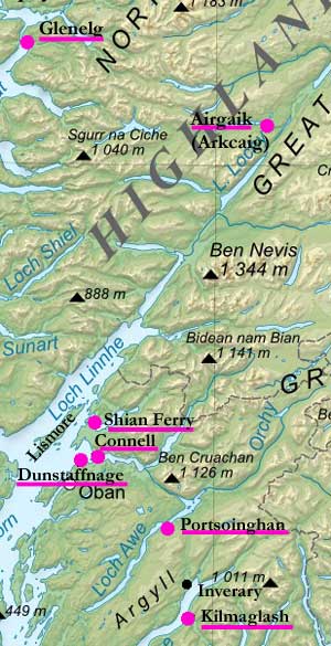
145 Mention of ferries at Kilmaglash (Strachur) on Loch
Fyne and Port-Chregan on north side of Loch Fyne. Page
145 Mention of ferries at Kilmaglash (Strachur) on Loch
Fyne and Port-Chregan on north side of Loch Fyne.
Page 147 There is a ferry on Loch Awe at Portsoinghan.
The way there from Inverary is very dangerous in “time
of evil stormie weather and in winter”
Page 150 There is a ferry between Dunstaffnage and Gonnell
in Lorne (presumably North Connell) which is a very
difficult passage.
Page 154 Ferry of Sion (Shian Ferry) between Beandirloch
and the Appin.
Page 155 Ferry of Lismore.
Page 170 Glengarry “In the water
or river of Airgaik there was seen in the zeare 1620
yeirs the fourteenth of August, the tennants and gentle-men
of the Countrey being at the building of a bridge of
timber on the said river, at the latter end of the making
of the bridge, there appeared Innumerable Adders in
this water of Airgaick Immediatlie efter the finitione
of the said bridge. The gentlemen and tennants perceiving
the Adders and all the water in such a pairt a litle
above the bridge full of cruell and terrible beasts
and certaine of the biggest of the adders did lope high
above the water, and certaine others of them comeing
to the land, did goe through the hadder and grass so
fast that the whole Companie which did behold, were
much affraied at this terrible and Marvelous sight.
And at last they were forced to leave their work and
depart from that place, which they did say, if there
had bein such sight at the beginning of the work, they
had never did it.” - see also page
524
This may have been Loch Arkaig
- see map by Robert
Gordon and 1st edition of the 1" map, sheet
62
 Page
174 There is a ferry between Glenelg and Slait. Page
174 There is a ferry between Glenelg and Slait.
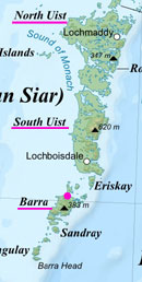
Page 178 In Barra people come from five miles away
to collect cockles at Kilbarray.
Page180 In Uist several churches and lands have been
overrun by the sands and the sea.
These maps are based on a map of
Scotland produced by Eric Gaba and made available on
Wikimedia under a Creative
Commons licence and Commons:GNU_Free_Documentation_License.
With thanks. See original on Wikimedia.
A Description of Renfrewshyre
Page 201 Bridge in Pollockshaws.
Page 202 Bridge in Paisley over the Cart.
Page 205 Bridge over the Black Cart at the mouth of
the Loch of Semple near Eliestoun.
Kelly bridge (Clyde coast on border with Ayrshire).
Notes for a Description of
the two shires of Aberdeen and Banff in Scotland beyond
the Mountains.
Balvenie or Mortlach
Page 274 King’s highway to Elgin passes near Auchluncart.
Keith
Page 274 Keith is on the king’s highway. It has
a weekly market which draws people from the higher ground.
Kintore
286 Kintore is on the king’s highway.
Aberdeen
Pages 286/287 Bridges.
Note to the Map of Aberdeenshire and Banffshire
Page 290 Bridges in Aberdeen over the Dee and the Don.
A Description of the two Shires of Aberdeen and
Banff
Page300 Timber for the wood of Pananich near Glen Muick
is conveyed to Aberdeen but not by the rough and stony
road.
Page301 Kincardine, 18 miles from Aberdeen, is on the
king’s highway.
Page303 Bridge over Don in Aberdeen.
Page 305 Details of fairs in the shire all of which
brought people from the surrounding localities and from
further afield. Mention of road from Aberdeen to Strathbogie
in connection with St Serf’s Fair. There is another
fair at Kincardine on the Dee “by which those who
journey across the Grampians into Moray or farther north
must pass.”
Description of Moray
Page 310 The Spey has no bridges and hardly any fords.
Aberdeen
Page503 “Two miles from the town, travellers
to the south come to the bridge over the River Dee.
The piers are eight in all, united by seven arches of
square-cut stone. Scotland shows none more beautiful.
It was founded at the expense of William Elphinstone,
Bishop of Aberdeen, about the year 1518. The work was
superintended by Gavin Dunbar, his executor, who on
the completion of the bridge in the year 1527 gifted
his estate of Ardlair to the people of Aberdeen, so
that with its annual rents the fall of the bridge should
be provided against for the future, or if damaged it
should be repaired. Near the bridge also stood the chapel
of the tutelar Mary, which too was destroyed in the
last century, while the bridge is still safe. “
Page 508 Description of the Bridge of Don with it “joining
the banks of the river with a single, but very wide
arch, nor could you easily find one like it, with its
substructure mostly of stone dressed and squared. Both
its abutments are fixed in position on a rocky foundation,
and with curve break the force of the strong current
One might say that nature pointed out the site for the
bridge. “
Also
“Who the builder of the bridge across the river
was, no one knows. It is said that the gallant King
Robert the Bruce, when he expelled Henry Cheyne, Bishop
of Aberdeen, from his Episcopal see, and indeed from
Scotland, ordered the annual revenues of this bishop
to be devoted to pious uses, and that part of that money
was spent on the building of this fine bridge, which
is also probable.”
Cowell (this and some of
the other items are repeats of previous entries above)
Page 511 Ferries mentioned: ferry of Lochfyne at Kilmaglais
which is 15 miles from Dunoon and Port Chregan on the
north side of Loch Fyne, three miles from Inverary.
There is also a ferry on Loch Awe.
Page 515 Ferry of Gonnaill in Lorne.
Page 516 Ferry of the Sian between Benderloch and the
Appin.
Ferry to Lismore from Appin.
Page 524 “Anno 1620 in the beginning
of August, the people of the countrey were building
a bridge upon the river Airkaig, at the end of the work
they report they saw an infinit number of adders swymming
upon the water, a litle above the bridge, leaping theron,
wherof many landing creeped away throch the
grass and hather, to the great terrour of the beholders,
“-see also page 170
Memorandum for Knodeord (Knoidart)
Page 526 There is a ferry from Killchuimen to Slait
in Skye.
Noates of Distances of places about head of Loch
Tay, Loch Erin (Loch Earn) etc
Page 538 Some distances between places are given (which
probably imply routes between these places) - among
the entries are a mention of the ferry on Loch Awe and
that St Johnstoun and Ballach at the foot of Loch Tay
are 26 miles away by Dunkeld but only 18 by the nearest
way which is through Glen Almond. (see also p595 below)
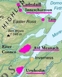
Urwhodin (an area on north side of Loch Ness,
about 10 miles from Inverness - see Blaeu. Probably
identical to or covering much of Urquhart parish)
Page 550 Some distances between places in Urwhodin,
are given which may imply routes between them. One entry
is a specific mention of a route, viz. “Item Lochen
Ruddich the litle as we pass from Urquhodin to Invernes
the hie way.”
 Connel
or Connen River Connel
or Connen River
Page 551 Mention of a cobil (boat) “whair we cum
over” on south side of Connel.
Ard Meanach (the Black Isle just north of Inverness
- see Blaeu)Page553 Distances between places in Ard
Meanach. Mention of the ferry over the Connel.
The Draught of Charroun River and Okell River
(these can be seen on Blaeu's
map of Northern Scotland - Innercarroun is opposite
Bonar Bridge, Carbsdaill is near Invershin, 3 or 4 miles
to the NW and Ochtow is a few miles up the Oykell)
Page 569 “Now to go from Innercharroun west up
the ferry, the way to Stra Okell is Carbsdaill on the
ferry syd, a long myl string way but the bending of
the ferry maketh the jomey a great deal longer.
It is betwix Ochtow and Carbsdaill 7 myl down the Ferry
Seitt.”
Various places on “the way alongs the Ferry syd
fra Innercharroun to Tayn” are given, with distances.
(Note: Map based on a map of Scotland
produced by Eric Gaba and made available on Wikimedia
under a Creative
Commons licence and Commons:GNU_Free_Documentation_License.
With thanks. See original on Wikimedia.)
Noats of Lennox and Sterlingshyr
gotten fra Gentlemen of that countrey
15 May 1644
Page 578 Starting with this section many distances are
given between localities in various districts and probably
imply routes. See the section Roads
in the 1600’s on this website for details of
some of these entries, particularly Upper & Lower
Clydesdale and Stirlingshire. Some entries, however,
look more like topographical description giving the
position of houses and farms in relation to rivers and
towns - see NLS for more details.
Entries that refer explicitly to a route/highway etc
are noted below.
The Isle of Skiana commonlie called the Skie
Page 582 “Item the ferry toun under Binscard called
Scosa. “
“Item the hie way throw thois hills is called Bellachan-Scard.
“
Distances in Carrict and the adjacent Shyre
Page 584 Glen Ap is in Galloway in the way betwix Chappel
and Balintrae betwix a place cald the thrie standing
stains whilk is in the hie way and the said Glen Ap
is 6 myl. and heir endeth Galloway and beginneth Carrict.
Divers Distances
Page 586 See Roads
in the 1600’s: Upper & Lower Clydesdale
for more details.
Kyle
Page 587 “The town of Ayre standeth on the southsyd
of the river with a fair stone bridge of ane arche,
a good port, and much frequented.”
Page 589 “Irwing toun is on the northsyd therof
at the sea with a fair stone bridge, heir is a convenient
haven for ships.”
Cuningham
Page 590 “Betwix Stewarton kirk and Corsell is
Cochelvy and betwix them is
Chapil burn with a bridge. North fra Corsell another
bridge on Chapill.”
Page 591 Stone bridge in Kilwinning.
Page 591 On the poynt therof standeth the Castle Paincors.
following the coast twa myl is Hunterstoun, and here
you touch the sea agayn in the way to Largis.”
Divers Distances and Lenths
of Rivers (mostly SW Scotland)
Page 592 Annand town in Annandail and Edinburg. 56 myl.
the way is up the hail river Annand to the springs still
north then down Tweed fra the springs while you fall
in Lothian the draught of Tweed falling that lenth almost
nord-east.”
Page 593 “Dumbarton and the ferry of Lochgher
as you goe to Rosneth 8 m and 2 to Rosneth fra the ferry.”
“The hie way fra Edinburgh to Glasco is throw Falkirk.”
“LochGilb makes a bow in the way from Innerara
to Tarbat castel and makes it 28. but the straight will
be 26 be the Marquis Argyls relation from whom I have
it. “
Mention of bridge of Stirling.
Page 594 Mention of bridge of Ruthven and Brig of Ern.
Noats of distances for Badenoch
Page 595 “Ruffen in Bodenoch and Elgyn ar distant
the nearest way 36 myl. the way is by Creig Elachy,
whilk is foment Rothimurcus throw Bulladorn, by the
kirk of Duchel to Lochenduyrs, holding the southsyd
therof, to the castell of Dunsale then throw the Glen
of Pluscardie. “
The reference to the “way” suggests that the
immediately following distances (mostly NE Scotland,
Perth, Stirling) also indicate routes. Among these are:
“Balachastell Ruffen 16 myl, viz 10 to Rothimurcus
thence 6 myl to Ruffen all this long way. “
Noats about St. Jhonstoun and in Stratherne
Page 595 Mention of Bridge of Earn.
Braid Albayne
Page 598 “Ther is a way from the yate of Blair
in Athoil to Ruffen in Badenoch maid be David Cuming
Earle of Athoill for carts to pass with wyne. and the
way is called Rad-na-pheny or way of wane wheills. it
is layd with calsay in sundrie parts. “
Divers Distances in Lennox, Sterlinshyre,
Clydsdail, Cunningham 1646
Page 604-607 Again many of the entries on these four
pages undoubtedly imply routes - specific references
are:
Page 605 Wigtoun 12 Ferry toun
Brig of Drumfreis and brig of Cluden 2. m.
Brig of Cluden and Brig of Dunskarr 2 m.
Page 606 Bargeny on Girven river 3 m fra the sea, 5
m fra Moniboll
the way to the Chappell.
Seats upon the bounds betwixt Ainrick Blayne and
Forth Rivers
Page 609 Mention of a coble (boat) at Wester Frew and
a bridge over the Guydie.
The Northsyd of Teeth River
Page 612 Mentions of the brig of Doun and a bridge at
Derrara.
A Description of the Shire
of Edinburgh
Page 629 There are bridges on the Almond at Upper Cramond,
Hallistonum (Illieston), and at Calder.
Page 631 The bridge at Musselburgh has three arches.
On the North Esk there are bridges at Dalkeith, Lasswade,
and Roslin.
On the South Esk there are four stone bridges: one below
Dalkeith, another below Newbotle, the third at the head
of Newbotle, and the fourth at Dalhoussie.
Page 635 There are many pack horses in the shire which
are used to bring in fuel, food and drink to Edinburgh,
as well as merchandise to and from Leith.
Volume III
Copy
of volume III on Internet Archives
Haddington
Page 65 The town is on the post road to Edinburgh. Bridge
in the town with another bridge downriver where there
was an nbbey founded in 1182 on its north side. There
is a forty foot highway to the port at Aberlady; and
another highway 80 foot wide through Gladsmoor, 3 miles
west of the town.
Orkney
Page 84 Ordinary ferry for Orkney at Duncansbay.
Survey of the Town of Aberdeen
1685
Page 89 “It’s not to be omitted the Town hath
set up at every entry of the Town, seats of hewn stone
for the accommodation of old men and women going to
horse, which is very usefull, and a comely thing.”
In the past a ferry boat had to be called from Torrie;
now there is one at the mouth of the Dee, near the Blockhouse.
Page 90 The causey of the Castle Gate has now been repaired
(it was so hollow the dubs and rains stood in pools)
some 50 years after the other streets were causeyed.
Page 94 One can pass on foot or horse between North
and South Uist at low tide.
Mention of a highway at New yeard near Paisley.
Page104 Bridge at Broray (9 miles east of Dornoch)
in Sutherland.
Page 105 There is a hill in Southerland called Ord
very high, and of dificile passage, by the which men
do travel into Catteyness.
Description of East Lothian
Page 111 Six bridges on River of Tine - Lintoun Brigs,
Abbey of Haddington, Haddington, Pencaitland, Ormestoun,
Nether Cranstoun.
Page 114 “Only three passages fro Draughts viz
at Cockburnspath on the East, at the Myln know in the
middle, and Soutray on the west, and all thir three
passages very uneasy.”
Description of Midlothian or Edinburghshire
Page 116 Three bridges on the Almond: at Over Cramond,
Hall Liston and Calder.
Page 117 Mention of South Bridge of Calder.
Gogar Burn starts at Kirk Newton and runs 5 miles to
join the Water of Amand a “little be east the Easter
Brigs.”
Page 118 Bridge at Musselburgh & Pinkie.
Page 119 The North Esk has bridges at Dalkieth, Lesswade
and Rosline.
Page 120 The South Esk has bridges at Dalkeith, Newbotle,
at the head of the Toun of Newbotle and one at Dalhousie.
Page 123 In Leith a great many horses are kept by carriers
for carrying from Leith to Edinburgh.
Page 124 Tradition that there were underground passes
on the Antonine Wall running between Castle Cary, Barhill
and Kirkintilloch.
Description of the Sherrifdom
of Renfrow etc
Page 127 Bridges in the shire are Paslay, Pollok, Johnstoun,
Ramforlie, Calder, Kellie and Allerslie etc.
Page 127 Ferry on water of Cree, Wigtonshire.
Description of the Sherrifdom of Lanerick
Page 131 Distance of Errikstane to Partick Bridge is
40 miles.
Page 132 Mention of Montjadifoord near Lamington.
Page 133 Mention of Calder Bridge (on North Calder)
and Glasgow Bridge.
Description of the Sherrifdom
of Roxburgh
Page 136 “Jedd Water beginning at the Quheill Causey
in the border of England runs to Jedburgh where it has
a bridge….”
Mention of Ancram Bridge near confluence of Gall Water
and Teviot.
“Bowmont Water begins at the Cocklaw (border with
England), runs eastwards till it comes to the Strawfoord
and there tynes its name and goes to England.”
Page 137 “The mountains therein are the Cocklaw
(Cheviots)…which is only passable at some few parts.”
Description of the Sherrifdom of Selkirk
Page 138 “Tuna (tributary of the Water of Ettrick)
runs from Tomluther Crocestane…”
Description of Tweeddale
Page 141 “The mountains betwixt Minchmoor and Henderland
are “black and craggy, of a melancholy aspect,
with deep and horrid Precipices, a weary and comfortless
piece of way for travellers.”
Page 145 Mention of Cauldstane Slap
Water of Lyne runs into Tweed near the Bridge of Lyne.
There are four bridge on the Lyne: Brighouse Bridge,
Bridge of Lyne, Lyntoun, and Newlands (of timber on
a stone stool).
Stainypath near this river.
Regarding Linton, “the inhabitants of this town
have still been a gentle and courteous people accussed
partly by their continual converse with strangers upon
the road this being the high way from Edinburgh to Moffat,
Dumfries and Carlisle.”
The greatest sheep market in the south of Scotland is
held in Linton.
Page 147 A Cold Coat near Romanno (Note: some say that
this place name indicates a Roman road).
Page 149 Church and town of Lyne - there is a possible
Roman fort here and a laid causey half a mile long can
be seen.
Page 150 There is an old bridge on the Water of Manner
at the confluence with the Tweed and a bridge at Peebles.
Information concerning Teviotdale
otherwise called the Shire of Roxburgh
Page156 At Roxburgh castle there were bridges over both
the Tweed and Teviot.
Page157 More than 10,000 loads of corn are sent to Newcastle
each year.
Page159 There are “the vestiges of a street that
goes from the Border, viz from Hownam to Tweed called
the Roman Causey, commonly called by the vulgar the
rugged Causey.”
Description of the Sherrifdom of Selkirk or Ettrick
Forest
Page 164 Galashiels has a weekly market and several
fairs each year.
Page 165 At Deuchar there is a bridge over the water
of Yarrow.
Page 166 There is a stone bridge over the water of Ettrick
near Kirkhope close to the confluence of Yarrow and
Ettrick.
Page 167 Other bridges over the Ettrick are near Howfoord,
Qwhittlebrae, Hottrolben, Inner Huntie
Page 169 “There is a well at Philiphauch not inferior
to Moffat which is much frequented.”
A Description of Berwickshire or the Mers
Page 170 The only bridges over the Tweed are that of
Peebles with 5 arches and that at Berwick with 15 arches.
There had been one at Melrose, “the pillars whereof
still stand.” A bridge is planned for Kelso.
Page 174 Fairs at Lauder.
Page 175 Mention of Redpath near Earlston.
Page 176 Mention of Smailholm Spittle.
Page 180 Duns has a “great weekly market”
and fairs.
Page 185 “Few bridges. A timber one at Lauder over
Leider, Stockbridge upon the head of Eden, three over
Blacater - one at Westruther, one at Greenlaw, a third
at Fogo, two over Whittier - one at Longformacus, the
other at Chirnside, one over Ey at Aytoun, one over
Ell at the Press, ere it enter Ey, one at Cockburnspath
on the Post Rode.”
A Brief Description of the
bounds of Presbytery of Penpont, being the upper part
of the Sherrifdom of Nidesdale
Page 198 Coal pit at Parbrock with curious pillars shaped
by the Picts.
Page 201 Dalvine standing in a Pass betwixt 2 hills
near to Crawford Moor. “Upon the north side of
which pass lyeth the lands of the Lordship of Castlehill,
whereon stands the Castle of Durisdeer upon another
Pass called the Well-path that leadeth to Crawford-Moor…”
Edward I garrisoned this to keep the pass.
Page 202 Bridge to Dumlanrig; bridge of Drumlanrig near
Enock.
Page 202 Penpont “is denominate Penpont from a
Penny payed at this place for building and upholding
of a Wooden Bridge over Nith betwixt Penpont and Morton
long since ruined near to a village called Thornhill.”
Page 205 Moniave has a “weekly Mercat and some
Fairs.“
Page 208 Near Closeburn there is an old chapel and a
trench for keeping of a Pass - near to Clawghrisa and
Over and Nether Algirth.
Renfrewshire
Page 213 Mention of bridge of Paisley.
Page 214 There is considerable carriage between Port
Glasgow and Glasgow. Boats can reach Paisley and Renfrew.
Page 215 Reference to an old Roman street from Erikstone
in the head of Eusdale to Mauls Mire (Watling Street)
and a camp at Paisley.
Page 217 List of churches appended to Paisley.
Page 213 “The Black Cart rises Lochwinnoch Loch
at the mouth of which it is many times not fordable.
Runs dead and low through the mosses.”
Mearns
Page 237 “Among the Grampian Hills that fall into
the Merns, these are remarkable: the East most Carmarthen
a passage to Deeside, upon the West side thereof, called
Slug of Gellan. The next Carlaouk. The third Clochnaben,
which signifies, as some say, a White Stone, because
upon the head thereof, there is a stone as big as a
little mountain…..”
“Cowy mouth is ten miles in breadth, dangerous
in former times to pass, by reason of Robbers, but for
the most part manured and made fertile by Brunt land
both in Oats and Beer. The way is stony and mossy. There
be two Causeys in the Mouth, the one about three quarters
of a mile, the other a quarter. Without these two the
passage to Aberdeen were impossible in the Winter-Season.
The first founders of these Causeys are uncertain. There
is an old Husband town near by them called Cookstoun
given out in old, for the maintenance of these Causeys,
but of old being altogether come to decay, there was
a general Contribution by the Gentlemen of the Merns
for repairing of them. The town of Aberdeen collected
the same, undertook the same, have laid them de novo,
and finished the work in the year 1634, a fair Porch
being built at the entry thereof.”
For more information on the Causey
Mounth, see article
by C Michael Hogan on Megalithic Portal site.
Orkneys 1529
Page 320 “On Stromness there is a most dangerous
bridge for travellers, named (the Bridge of Naith) where
many perish.”
Top
|