Airth
 |
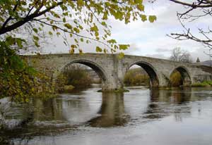
| The Clackmannanshire Bridge,
2009 |
OSA (bridges
& ferries) - on Edina page
go to browse scanned pages
There are 5 bridges on the river. The Abbey-town
bridge (NMRS record) on the Dunmore/Airth to Carron
and Falkirk road is thought to have been on a direct
road to an abbey in Airth.
There are ferries on the Forth at Kersie and Higgin�s
Neuk with piers on both sides. A boat sails between
Airth and Dunmore to Alva once a day. There are harbours
at Airth, Dunmore and Newmiln.
NSA
 |
| Kincardine Bridge - the ferry
slip was on the left of the picture |
Mention of Kincardine Ferry.
The Pow is crossed by some small bridges, one of which
is called the Abbey Town Bridge. The nearest market
town is Falkirk, six miles away.
There are 8 miles of turnpike road; the Glasgow to Alloa
coach runs each day and the Glasgow to Kirkcaldy coach
runs three days a week.
A fair for hiring shearers is held each July. Coal is
obtained a few miles away.
Alva
OSA
No mention
NSA
p. 185 There are five carters in the village. A carrier
goes weekly to Stirling and Glasgow.
Baldernock
OSA
There is not enough money to repair the many roads in
the parish. Some of the less useful should be closed
up and the money used on the more important roads. A
good turnpike from Balfron to Glasgow passes through
the parish although it is some distance from the centre.
NSA
Although Glasgow, the nearest market town is only 7
miles away, there are no coaches or carriers and no
post which places the parish at a great disadvantage.
A link from the Balfron to Glasgow road has long been
proposed and has now been surveyed. Once made we will
have two turnpike roads, the other being a road running
from west to east though the parish.
Many parish roads are needed but the statute labour
money will be insufficient for their maintenance.
One fair is held each year, for milk cows, but little
business is now done. Most of the coal is obtained locally
though some comes from Glasgow by the canal.
Balfron
OSA
Until recently roads were almost impassable in winter
but are now much improved.
There is a two-arch bridge over the Endrick at Ballindalloch
- when "swelled" this river is rapid and dangerous.
There is a turnpike between Glasgow and Balfron which
links to the military road between Stirling and Dumbarton
and one from Kippen to Glasgow. Other roads and bridges
are now being built.
NSA
; see also p. 302
Balfron is 15 miles from Stirling although the road
there is longer. The roads to Glasgow and Dumbarton,
although good do not have lines "which engineers of
the present school would adopt." There are daily carriers
to Glasgow as well as a coach and a postal service.
There are just under 4 miles of turnpike road.
Since the last Account of 1793 the roads are much improved
though more can still be done, and our communication
with other places has greatly improved. The arrival
of the first caravan for the "conveyance of goods and
passengers" was quite an event.
Bothkennar
Parish
map - sheet 31, just north of Falkirk
OSA
Old people remember when the roads were near impassable
but these are now in good condition except in heavy
rain or flood. A new bridge is to be built across the
Carron just above Grangemouth and a new road from Grangemouth
to Alloa and Stirling.
NSA
The parish is well served by roads which are maintained
by statute labour. Falkirk is the market town. Coal
is obtained locally.
Buchanan
OSA
Timber is taken by water from the shores of Loch Lomond
to Glasgow, Port Glasgow, Greenock and sometimes Ireland
and the west of England.
There is a new road between Drymen and Rowardennan from
where the Dunbarton to Inverary road can be reached
by ferry. There are quays both at Rowardennan and Arrochar.
Horses are available at a public house. The road from
Drymen is only now complete after 30 years work under
the statute labour system.
A garrison was built at Inversnaid about 80 years ago
to prevent stolen cattle being moved north through the
pass between Loch Catrine and Loch Lomond.
NSA
; also
The parish has no turnpike roads and there is no post
office.
There is a need to extend the road from Rowardennan
up to Glenfalloch to reach the Arrochar turnpike, and
also to repair the road to Inversnaid garrison which
would allow west Perthshire to be reached by Glenarklet.
Campsie
 |
 |
| Campsie kirk |
Looking from the
kirk up to the Crow road - at some point a track
was made up the hill |
OSA
A turnpike leaves the Military Road (Stirling to Dumbarton)
at Kippen and runs to Glasgow. Another road runs east
west between the great Edinburgh road at Auchinreach
and the Strathblane to Glasgow turnpike on the west.
In addition, two miles of the Glasgow to Edinburgh turnpike
by Falkirk runs through the parish and two cross roads
run from this to Kirkintilloch.
There are 20 miles of road in the parish, 10 of which
are maintained by statute labour. Prior to the conversion
of statute labour the roads were "miserable indeed".
Although there were 101 plough gates both in spring
and autumn with each equating to the labour of a man
and horse for 3 days, the reluctance to work and the
lack of skilled supervision and careless method of working
led to the roads being in very poor condition and almost
impassable in winter.
The conversion money raises 70 L per annum and up to
3 years ago this was spent on 18 of the 20 miles of
road in the parish. Now, with one line of road being
turnpiked, all this money will be spent on 10 miles
of this road and minor roads connecting to the other
turnpikes.
One obvious link is between Campsie Kirk and the Crow
Road (leading to Fintry and Stirling) - it would be
only 600 yards long but would save 3 miles.
Despite being a hilly district, there are very few pulls.
There are 19 stone bridges, 4 of which cross the Kelvin.
There are several causeways on the line of road to the
church, said to have been built by offenders in the
past as a penance. These are about six feet wide, formed
of a large whinstone in the middle with smaller ones
on each side.
One noticeable defect in the roads is that due to the
soil being gravely, a thaw after severe frost can make
the ground very spongy and travel difficult.
It has sometimes been proposed to have a turnpike from
Kilsyth to the Military Road near Buchanan House. It
would run through the straths of Campsie, Strathblane
and Killearn, with a bridge over the Leven at the boat
of Balloch. This would make travel between Edinburgh
and the West Highlands shorter than through Glasgow
or Stirling. Recently a turnpike bill has been passed
which will allow such a road to be built through Fintry
and the valley of the Blane.
Cottars and tradesmen complain about having to pay 2/-
in lieu of four days statute labour despite the benefit
they gain from the improved roads and the fact that
it costs them much less than having to provide 4 days
labour.
The development of transport in the parish is shown
by some facts from the past:
• In 1714 there were no carts or chaisses; the
gentry rode to church
• In 1744 there was no chaisse in the parish; only
a few carts with timber wheels which were used for moving
manure in spring time
• In 1759 there were two wheeled chaisses and 20
carts with iron-shod wheels
• In 1794 there were 200 carts, 4 post-chaisses,
3 coaches and one 2-wheeled chaisse.
NSA
There is an east-west road from Strathblane to Kilsyth
which is crossed by one from Glasgow over the Campsies
to Fintry and Kippen. The Glasgow- Kilsyth- Stirling
road passes through the SE corner of the parish. A coach
runs to and from Lennoxtown to Glasgow five times a
week.
Denny
OSA
The roads are in good repair.
NSA
There is a bridge
(NMRS record) over the Carron called Denny-bridge.
The old village lies on the road to Falkirk and Edinburgh.
A new turnpike road enters Denny from the south with
a bridge over the Sclanders Burn. There is a new bridge
on the Fintry road, 5 miles west of Denny. Beyond Broomage
tollbar, the road splits near Hags to give two routes
to Glasgow.
Denny has a post office. There are over ten miles of
turnpike here. More than twenty public carriages pass
through each day in wintertime. Bridges are well kept.
There are two fairs. Coal is obtained locally.
Drymen
OSA
Nearest market town is Dumbarton, 11 miles away. Glasgow
is 18 miles. Lime and coal are brought from Kilpatrick,
some 11 or 12 miles away. Many vagrant beggars.
No mention of roads
 |
| The Clachan, a droving inn licensed
in 1734 |
NSA
Apart from the Glasgow markets, produce is sold at Duntocher
and at towns on the Leven.
There are ten miles of the Glasgow and Dumbarton road
by Drymen to Stirling, and 35 miles of parish road.
The latter are maintained by statute labour at a cost
of L120; and are not always in the best condition.
There is a fine bridge one mile from Drymen over the
Endrick that was built in 1765, and the Finnich bridge
which crosses a ravine - it has recently been widened
and improved.
A stage coach runs to and from Glasgow three times a
week; there is also a weekly carrier and a daily postal
service.
Coal is expensive because of the distance it is brought
from Garscube, hence many use peat which is easily obtained.
Falkirk
OSA
Callendar
House
p. 72 The north road between Edinburgh and Glasgow runs
through the town as does the road to Stirling and the
North Highlands.
p. 90 A canal crosses the Glasgow to Stirling road on
an aqueduct.
p. 93 People in Grangemouth who have to go to the custom
house in Bo�ness sometimes have to travel by Linlithgow
bridge when the Avon cannot be forded - this adds four
miles to their journey.
p. 83 There are three trysts, several fairs and a weekly
market..
Near Callendar House there is an earth wall that branches
off Graham�s Dyke and runs over to the old castle of
Almond - it may have continued to a camp at Linlithgow
and may have been a road.
 NSA;
Romans;
Means
of Communication, Roads
& Bridges
NSA;
Romans;
Means
of Communication, Roads
& Bridges
A Roman road runs through the parish from Castlecary
fort to Camelon. Some parts are still used as a road.
Falkirk is the only market town. The turnpike between
Edinburgh and Stirling and Glasgow runs through the
centre of the town. The town is usually busy but more
especially on market and fair days and when the cattle
trysts are held. These take place at Stenhousemuir,
3 miles away.
Means of Communication The main post office
is in Falkirk with several smaller ones elsewhere in
the parish. Post goes twice a day to Edinburgh and Glasgow
Stirling and Alloa etc. Runners deliver the mail throughout
the parish each day. Passage boats run to Edinburgh
and Glasgow on both the Union canal and the Forth and
Clyde canal (at Lock No.16) several times during the
day and night. There are two coaches daily to Edinburgh,
Glasgow and Stirling and daily coaches to Dunfermline
and Kirkcaldy.
Roads There are ten miles of turnpike road
with many parish roads funded by the statute labour.
Bridges There are bridges over the Carron
and water of Bonny including a drawbridge over the Carron
on the way to Bothkennar which allows vessels to pass
through. There are five drawbridges over the Forth &
Clyde canal and several roads cross the Union canal
by bridges. One mile west of Falkirk the turnpike road
used to pass under the Forth & Clyde canal but it now
crosses over it by a drawbridge. Coal is obtained locally.
Fintry
OSA
There is a cotton mill at Culcruich beside the turnpike
road.
Peat is used but too much time is spent in obtaining
it.
It is only in the past couple of years that the formidable
obstacles to communicating with other places have been
overcome. Access was very difficult with a near perpendicular
hill between here and Campsie and Glasgow which half-laden
horses could hardly negotiate, and deep mosses to the
north and west. Two local gentlemen, at much expense
to themselves, obtained an act of parliament for new
roads in the west of the county. Now the roads are as
good as anywhere.
The Craw Road comes from Glasgow and the gradients are
much easier - it runs up to the military road between
Stirling and Dumbarton six miles north of here. The
county road on the west has now been repaired. There
are many bridges over streams which used to be difficult
to cross. The bridge over the Endrick has four arches
and the bridge on the old line of road, one mile upstream
from this, has two arches.
NSA
; fuel
The Kippen to Glasgow coach which ran for several years
through here is no longer in business. Carriers run
to Glasgow every two days.
There is no post office. The large cotton factory built
some 45 years ago has helped improve the roads somewhat
but its distance from Glasgow and the hilly road between
makes carriage of its produce very expensive. Coals
also come by this very hilly road, from Kirkintilloch.
Gargunnock
OSA:
roads
in the carse ; boats
; military
road
The muir is accessed by narrow passes called ballochs.
General Campbell of Boquhan has recently built an excellent
road, six miles long, from the ford of Frew to his muirland
- it is suitable for carts. Initially the tenants of
the muir were hostile but they now accept it.
All roads in the carse (excepting Boquhan and Micklewood)
are very bad and near impassable for carts - even travel
on horseback is difficult. Farmers often complain about
the roads and say they will work on them but as soon
as the weather improves they forget about the problem.
The best solution would be for landlords to make roads
to farms and recover the outlay from the rents.
Beggars pass through the parish and prove a nuisance.
The Military Road runs through the parish.
Coal is brought 10 miles from Bannockburn.
Tenants beside the Forth have boats but these are not
suitable for horses or loaded carts.
A bridge is required near Micklewood - the bridge at
the ford of the Frew "does not sufficiently accommodate
those for many miles�"
The Military Road between Stirling and Dumbarton, made
30 or 40 years ago, is to become a turnpike. So long
as the trustees confine their work to reducing gradients
on the road and shortening distances there are clear
benefits. However, if new lines of road are made, unnecessary
expense would be incurred in purchasing and enclosing
land, and some villages would be by-passed. The benefits
of improvements made to lands on the assumption that
the present road would continue would be lost.
NSA;
bridge;
miscellaneous
observations
The Peel of Gargunnock is thought to have protected
a ford. Further upriver a small fortress defended the
Ford of Frew. Just half a mile above the Peel there
was an old bridge called the bridge
of Offers (NMRS record) which Wallace is said to
have used. Its remains can still be seen. A suspension
bridge was built near here some nine years ago along
with a two mile stretch of road leading to the Stirling
- Callendar road.
Stirling is the nearest market town, some six miles
away. There is no post office although there is a delivery
and collection each day made by the Kippen post.
Four miles of the Stirling to Dumbarton road passes
through the parish. A new line of road was made fairly
recently half a mile from the village. This is a turnpike
road and a stagecoach runs on it on Fridays from Kippen
to the Stirling market. The bridges are in good condition.
Coal comes from Bannockburn and peat is obtained from
the moss of Kincardine along with some from the Lennox
Hills where sleds are used to transport it.
Although the new road through the carse is a better
road it is less scenic than the old Dumbarton road.
This ran past Touch, Gargunnock House, the village,
Leckie and Boquhan to Kippen. Some think that a new
road should be made from Fintry through the east side
of Balfron parish to pass along the foot of the Lennox
hills above Boquhan and Leckie to the new stretch of
the Dumbarton road in Gargunnock near the new bridge
over the Forth. Others think it should come down between
Boquhan and Leckie to the Dumbarton road. Routing it
through the "dryfield" part of the parish would make
it the shortest route between the Dunblane area and
Glasgow.
Killearn
OSA
; Black
Mail
There are two turnpikes. The statute labour rate is
18s per 100 L Scots for parish roads but these are still
quite poor.
Cattle thieving was common up to 1743. Protection was
offered to cattle owners by means of "Black Mail".
NSA
The remoteness from fuel, manure and markets is a disadvantage.
Before carts were used, coal was brought on horseback.
Some twelve miles of turnpike roads were built between
1790 and 1800 but are hillier and longer than they could
have been. The smoothness and firmness of the Macadamised
surface allows heavier loads to be drawn by horses.
Kilsyth
OSA: Bridges
; roads
; new
road by Cumbernauld
All the streams on the Glasgow road are bridged. The
most significant bridges are over the Carron, and over
the Kelvin at Auchinstenie. Antiquarians had thought
that the Auchinstenie bridge was Roman because of it
being near the Roman wall and its appearance (9 foot
wide, no parapets, a footway on either side, and 6 arches).
This is now discounted as the remains of a paved ford
were found near the bridge and there was a tradition
of someone perishing 100 years ago on the ford. Old
records show that the bridge is fairly recent as an
application to build a bridge was made in 1670.
The roads are good with many carts and carriages. In
the past the roads were narrow, rugged and far too steep.
Up to two years ago the main road between Edinburgh
and Glasgow ran through Kilsyth and Kirkintilloch and
was very busy. With the opening of the new road via
Cumbernauld there is now hardly any traffic through
here. There used to be two flys, a dozen post-chaisses
and 20-odd post horses in the village but these have
mostly gone. The income from the old road (a turnpike)
has dropped from �145 to �51 with hardly any profit.
NSA
Kilsyth lies on the northernmost road from Edinburgh
to Glasgow and just 50 years ago was very busy with
traffic. Now only carts and post gigs are to be seen,
not even a post chaise. The mail coach was withdrawn
ten years ago; a post-gig carrying one passenger runs
between Falkirk and Glasgow. It is however easy and
inexpensive to use the canal to travel to Glasgow, Edinburgh
and Stirling (by a connecting coach) .
Kippen
OSA: Moss
Logan ; bridges;
carts etc ; roads/tryst
 |
 |
| Ford
of Frew |
Kippen |
In Moss
Logan (NMRS record), a way formed of tree trunks
has been found which is very similar to a Roman way
over the moss of Kincardine.
There are bridges over the Forth at Cardross (1772)
and Frew (1783). In 1745 the rebel army passed over
the Ford of Frew on its way to Stirling.
There are 285 carts and three 2-wheeled chaisses in
the parish.
The road from here to Glasgow by Campsie moor used to
be very bad and near impassable in winter. It was turnpiked
in 1792. An act has now been obtained to turnpike the
Military road and as the two roads pass through Kippen,
this will be of much benefit.
Kippen would make a good location for a tryst.
NSA
Stirling, 10 miles away is the nearest market.
Kippern and Buchlyvie have regular postal services.
Seven miles of the Sirling to Dumbarton road run through
here and there is a good turnpike from Kippen to Glasgow.
There are bridges at Frew and Cardross - the Callendar
to Glasgow road uses the latter.
Coal comes 12 miles from Bannockburn and peat is also
much used. Coal and lime being so distant, it would
be advantageous to have a canal or railway here.
United
Parish of Larbert and Dunipace
OSA: cattle
tryst p. 335; Roman road p. 336; roads p. 337
A cattle tryst is held in October with 20,000 to 30,000
cattle.
A great Roman causeway that ran from Carmuirs camp in
Falkirk parish, crossed the Carron by a bridge west
of Larbert, and took a direct line to Stirling Castle,
is still entire in many parts today.
The Stirling to Edinburgh road passes through the parish
with a toll at Torwood. The rest of the roads are statute
labour.
NSA;
see also
; Dunipace
The Falkirk tryst is held here, there being three large
markets for the sale of black cattle, horses and sheep.
Details given of the Carron Ironworks. Slag was used
to repair the roads.
Penny-posts at Carron and Larbert. The mail coach and
another coach come through Larbert and there are coaches
to Glasgow and Edinburgh that pass through Carronshore.
 |
| One of the hills at Dunipace |
Dunipace There was a fine hill some
40 feet in height that was thought to be artificial
and which was quarried for stones for the roads, including
the construction of an embankment on the turnpike near
Denny bridge. However, although some human remains were
found at the top, the hill proved to be natural. The
name Dunipace is thought by some to mean "hills of death"
(there being some small low hills here), perhaps relating
to the ford hereabouts that must have seen many a conflict.
A bridge was built over the Carron near Dunipace House
in 1824. Before that time a ford was used for carriages
and "steps" for people on foot. The old
bridge over the Carron (NMRS record) between Dunipace
and Denny was replaced in 1828 because it was too high
and narrow for carriages, and also unsafe.
Logie
OSA
No mention of roads
NSA;
Roman
ford & causeway
There was a Roman fort and causeway across the Forth
at Manor. Part of this causeway was broken up some years
ago.
Stirling and Alloa serve as market towns.
The turnpikes to Crieff, Alloa, Dollar and Stirling
amount to about twelve miles of road and cross each
other at the village of Causewayhead. The roads are
poor, particularly the Crieff road which in addition
is "rendered impassable by tolls" - it has seven tolls
within two miles of the manse.
Letter carriers bring the post from Stirling.
The Perth to Glasgow mail coach passes through as do
two other coaches, and there is an omnibus between Stirling
and Alloa and one in summer from Bridge of Allan to
Stirling.
There is a fine new bridge over the Forth at Stirling,
the old one being thought unsafe. The bridge over the
Allan is old, narrow and dangerous.
Muiravonside
OSA
No mention of roads
NSA
p. 211 Linlithgow Bridge was built about 1650.
p. 213 Falkirk though further away than Linlithgow is
preferred as the market town. As well as the Union Canal
and railways, the Stirling to Edinburgh road runs through
the parish.
Polmont
Parish
map - sheet 31, just east of Falkirk
OSA
No mention of roads
NSA
Falkirk is the nearest market and post town, though
the runner has such a large area to cover that mail
is often delayed.
The parish has two miles of turnpike with regular coaches
to Edinburgh, Glasgow and Stirling. The Union Canal
runs through here and a railway is projected.
St Ninian�s
(formerly Eggles)
OSA
; Roman
road
A road runs 15 or 16 miles from Powbridge in the east
of the parish over to Randyford in the west.
A Roman causeway runs NW through Torwood. In the parish
there are 7 miles of the Edinburgh to Stirling turnpike,
5 miles of the Stirling to Glasgow road and 12 miles
of the road from Dunbarton to the ferry near Alloa.
Roads and bridges here are good.
The statute labour conversion money is 18/- per 100
L Scots.
NSA;
Romans 1-p.315
and p.322
Lime and coal are shipped from Fallin and bricks and
tiles from Throsk.
The Roman road through this parish has been used by
different armies in the past. Where the road meets the
Forth, opposite Kildean, the battle of Stirling (Bridge)
was fought in 1297. There was a ford some two foot deep
at low water and a wooden
bridge (NMRS record - see Stirling below) which
was capably used by Wallace to defeat the English.
There are several Roman posts in the area, with good
intervisibility between some of them which would have
allowed rapid deployment of troops.
 |
 |
| This unusual bridge
was designed by Thomas Telford. Along with its associated
road, it replaced the original route through Bannockburn
over the nearby Old Town Bridge in 1819. |
Map of area. Based
on 1" OS map, 1906. With thanks. The Old Town
Bridge {NMRS
record) was built in 1519 by Robert Spittal
who also paid for the bridge
at Doune to spite the ferryman who refused to
carry him across. |
Stirling is the market town although Falkirk is also
attended. Post is delivered from Stirling.
The Glasgow and Edinburgh roads run for several miles
through the parish; both with regular coach services.
There is also the road from Dumbarton to the ferry near
Alloa and from Carron-bridge to Randieford. There are
many small bridges.
There is an important cattle and horse fair held near
Bannockburn which is attended by dealers from Edinburgh
and Glasgow and other places nearby. Another fair has
declined in importance. Coal is obtained locally and
some peat is used in the higher parts of the parish.
Slamannan
or St Lawrence
OSA
The roads are very bad, however, a recent road through
the Moss Candle has made it much easier to reach Falkirk.
A proposed road between Edinburgh and Glasgow which
will go by Bathgate and Airdrie will also be of benefit.
NSA
There have been few changes here since the last Account
was written except in agriculture and the coming of
the railway.
A survey for a turnpike between Falkirk and Airdrie
was carried out a couple of years ago but it is likely
to prove very expensive to construct due to the nature
of the ground. However, the railway is sufficient for
reaching these places.
The distance from the lime works at Bathgate and Cumbernauld
and the poor roads are disadvantages to the parish.
Stirling
OSA
 Mention
of Stirling Bridge. Because of Stirling's situation
and its bridge, it is "the great thoroughfare of
the north of Scotland." Mention
of Stirling Bridge. Because of Stirling's situation
and its bridge, it is "the great thoroughfare of
the north of Scotland."
NSA;
Romans;
also
The Forth can be navigated as far as Stirling by vessels
of 70 tons.
The Roman road from Camelon northwards passed close
to the south-west side of the Castle-hill or perhaps
through a nearby hollow-way called Ballingeich Road.
The stone piers on which the bridge
at Kildean (NMRS record - see also 1,
2)
rested can still be seen under the river.
A considerable number of vessels use the port of Stirling.
Stirling serves as a market town and has several fairs
for horses, wool etc during the year.
Mail goes to Edinburgh and Glasgow and many other towns.
There are turnpike roads in various directions and many
public carriages on the roads. Some two or three steam
boats run each day to Newhaven or Granton Pier - these
call at other places on the way. Of the two bridges
over the Forth, one is very old and narrow.
Coal is obtained from nearby pits.
Streets in the town are much improved both in regard
to the causeway and the side-pavement.
Strathblane
OSA
Good roads in the parish. The Glasgow to Balfron and
the Glasgow to Drymen turnpikes are parallel to each
other, about 2 miles apart. Both join the Stirling to
Dumbarton military road. Another road runs NW from the
Edinburgh road near Kilsyth to the military road. The
western part of this road used to be impassable.
A bridge over the Leven (at Balloch) is proposed - this
would give a very easy route between Edinburgh and the
west Highlands. All these roads have been much improved
in the last 6 years.
NSA
The nearest market town is Glasgow and carriers from
Balfron go there four times a week as well as a coach
from Balfron three times a week. There is a daily post.
There are ten miles of turnpike road. Draught horses
find the road through the Strath difficult because of
its narrowness and steepness. There are ten bridges.
A cattle fair is held in November. Coal is brought from
Kirkintilloch, Campsie, Baldernock and New Kilpatrick.
Top
|


