|
Overview
The
sources examined so far give some indication of both
local and regional routes. Of the latter there are references
to a via regia between Forres and Elgin with a continuation
just to the east of Elgin and one from Kildrummie a
few miles south-west of Nairn which probably came from
Inverness; one to another via regia from Forres running
south to the Findhorn and another near the Spey, south-west
of Grantown. Several roads are mentioned near Ardersier
including a "hie kingis gaitt" but the course
of this is very difficult to determine. Another valuable
source for long-distance routes is the Itinerary of
Edward I on his campaigns in Moray in 1296 and 1303.
The
Forres - Elgin via regia is more than likely to be part
of a continuous route running between the early burghs
of Inverness, Nairn, Auldearn, Forres, Elgin, Cullen
and Banff. When taken in conjunction with Edward's itinerary
we can connect this with two routes to the south, one
to Aberdeen and so to routes to the south, and the other
to the strategically located Kildrummy castle and then
to other crossings of the Mounth and so to the south.
It is of course a moot point what relation these mediaeval
routes had to earlier dark age routes used by the Picts
who were extensively settled in both Moray and more
southerly districts.
The
Forres to Findhorn via regia and that near Grantown
have been thought by one or two of the earlier writers
to be one and the same route, with a presumed link to
Lochindorb castle, visited and possibly strengthened
by Edward. To the south of the second via regia (a stone
bridge over the Dulnan is mentioned) there is an intriguing
reference to a Rathad na Righ (King's Highway) on the
east side of the Spey (the via regia is on the other
side, at least as far as the bridge) which may possibly
be the same road and even be the Gartanrode of Edward's
itinerary. It would be very interesting if, following
the suggestion of C Marshall Smith in his Strathspey,
Highways and Byways, Elgin 1957, it could be proved
that there was a continuous via regia from Perth and
Dunkeld to Blair Athol then by Comyn's road to Ruthven
and then one or more of these more northerly stretches
of road as far as Forres.
 One
confusing factor in respect of the via regia near Grantown
is an old road that passes through Cromdale parish where
there is a ford over the Spey and which runs north to
Forres - see sheet
75 of the 1st edition one-inch map - which one or
two writers have equated with the via regia. This is
unlikely as it has a totally different line from the
via regia though it could be possible that the via regia
branched off from this road though proof would be needed
for this. One
confusing factor in respect of the via regia near Grantown
is an old road that passes through Cromdale parish where
there is a ford over the Spey and which runs north to
Forres - see sheet
75 of the 1st edition one-inch map - which one or
two writers have equated with the via regia. This is
unlikely as it has a totally different line from the
via regia though it could be possible that the via regia
branched off from this road though proof would be needed
for this.
The
road has been said to be Roman, coming from Braemar
but very few would accept this nowadays particularly
as it seems to have its origin in Charles Bertram's
forged writings of Richard of Cirencester, specifically
the itinerary of a Roman officer that took a road along
this line. Other theories are that it was made by the
Comyns or that it was an abandoned military road. The
course of this road can be seen on James
Robertson's map of 1822 (western sheets) as a "romanum
iter suppositum" running from Spittal of Glenshee
through Braemar to near Tomintoul, then Cromdale.
 The
charters and other documents looked at here are also
useful for more local routes although they often have
their ambiguities. Kinloss Abbey, which was a Cistercian
abbey founded in 1150 by David I as a daughter house
of Melrose abbey and itself founded new houses at Culross
and New Deer in the early 1200's, has a reference to
the via regia between Forres and Elgin and a Blakeford
which is difficult to identify. Other Kinloss charters
refer to a grant of Strathisla in Grange, Keith and
Rothiemay parishes which while not specifically mentioning
roads at least allows routes to be inferred. There was
also a grant of land in Gamrie parish in Banffshire
that mentions a highway. The
charters and other documents looked at here are also
useful for more local routes although they often have
their ambiguities. Kinloss Abbey, which was a Cistercian
abbey founded in 1150 by David I as a daughter house
of Melrose abbey and itself founded new houses at Culross
and New Deer in the early 1200's, has a reference to
the via regia between Forres and Elgin and a Blakeford
which is difficult to identify. Other Kinloss charters
refer to a grant of Strathisla in Grange, Keith and
Rothiemay parishes which while not specifically mentioning
roads at least allows routes to be inferred. There was
also a grant of land in Gamrie parish in Banffshire
that mentions a highway.
There
are also mentions in the charters of fishings, mills,
tofts in towns etc which would have some implications
for routes, though these are not dealt with here.
Although
not connected with the abbey it is interesting to note
a reference to a bridge near Kinloss that existed in
966 AD. A king called Dubh/Duffus had been assassinated
and his body placed under this bridge. See here
for details - go to Edit>Find on this page
and type Kinloss.
 There
are a number of references in the Register for the diocese
of Moray which was founded by David I in the early 12th
century. The early bishops had their seat at earlier
Culdee settlements at Kinneddar, Birnie and Spynie but
moved from Spynie to Elgin which was less remote and
relatively safe. Two of the references are to the via
regias near the Findhorn and south of Grantown which
have already been mentioned as well as a via regia just
east of Elgin, another in Inverness, as well as local
roads in these two burghs. There
are a number of references in the Register for the diocese
of Moray which was founded by David I in the early 12th
century. The early bishops had their seat at earlier
Culdee settlements at Kinneddar, Birnie and Spynie but
moved from Spynie to Elgin which was less remote and
relatively safe. Two of the references are to the via
regias near the Findhorn and south of Grantown which
have already been mentioned as well as a via regia just
east of Elgin, another in Inverness, as well as local
roads in these two burghs.
A
couple of fords are mentioned and some roads north of
Elgin near Loch Spynie, particularly interesting as
there had been a marine incursion that greatly increased
the size of the loch and covered over an existing landscape
that was revealed again when the loch was drained to
its present much smaller size. It is clear that there
was quite a network of tracks in this area.
Also
mentioned in the Register are a couple of bridges over
the Lossie and a high road near the River Doveran, as
well as many references to the Bridge of Spey, said
by antiquarian writers to have been Roman in origin.
When it finally decayed in the late middle ages it was
replaced by a ferry, the name Boat of Bridge retaining
a memory of the former bridge.
 A
charter for Urquhart abbey refers to a "grenegait"
which was a local track near Garmouth, and a more interesting
"king's road" that could point to a very old
road running south from Urquhart. The abbey was Benedictine
and founded by David I of Scotland in 1136 as a dependency
of Dunfermline Abbey. It continued under Dunfermline
until 1454 but the small number of monks living there
led to it being merged with Pluscarden in 1454. A
charter for Urquhart abbey refers to a "grenegait"
which was a local track near Garmouth, and a more interesting
"king's road" that could point to a very old
road running south from Urquhart. The abbey was Benedictine
and founded by David I of Scotland in 1136 as a dependency
of Dunfermline Abbey. It continued under Dunfermline
until 1454 but the small number of monks living there
led to it being merged with Pluscarden in 1454.
Also
included in this section are extracts from the Statistical
Accounts for New Spinie, Alvah and Boharm parishes relating
to mediaeval roads and bridges.
It
is clear enough from these sources that there was a
strategic network of routes that allowed control of
Moray and helped to incorporate it into the kingdom
of Scotland, and of more local routes that developed
in concert with the improvements made to the lands given
to the monasteries.
Invernessshire
Inverness
Several charters in the Register of Moray relate
to Inverness and refer to roads. Charter
237, page 304, dated from 1361 can be taken as an
example and refers to the Scathgate, a road to Kingsmills,
and a via regia (the High Street), all in present day
Inverness. See Am
Baile for a translation of this charter, also for
maps
of Inverness and area in the 1500's. See also chapter
one of Inverness
in the 15th Century by Evan MacLeod Barron, 1906
for a description of the streets and roads in the town.
A
document of 1611 concerning Temple lands belonging to
the Knights of St John, refers to various streets in
the town of Inverness, viz.
"that temple tenement of biggit
land with the yard thereof, lying in the town of Inverness,
on the north side of the hie gaitt, betwixt the tenement
of John Cuthbert on the east, the vennel or street leading
to the kirk of Inverness on the west, the high street
on the south, and the yard and back house pertaining
to the said John Cuthbert on the north, possessed by
Alexander Cuthbert and his subtenants;�another temple
land and tenement lying in the said burgh upon the south
side of the gait, betwixt the lands pertaining to on
the east, the passage or vennel that leads to the castle
on the west, the kingis hie streit on the north, and
the back land pertaining to on the south, possessed
by Alexander Bayne and his subtenants;�another temple
tenement of biggit land with yard and pertinents lying
in the territory of the burgh of Inverness, outwith
the eist port thereof, possessed by Finlay Mc faill"
The Book of the Thanes of Cawdor, page
266
Ardersier
(also Petty)
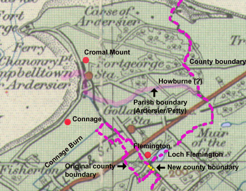 The
Knights Templar had various lands in the vicinity of
Ardersier which are described in The Book of the Thanes
of Cawdor, 1859, p.266ff. The
Knights Templar had various lands in the vicinity of
Ardersier which are described in The Book of the Thanes
of Cawdor, 1859, p.266ff.
One
charter of 1601 mentions a couple of these, as follows:
...in Ardrosseir by all right bounds, viz. beginning
at the great boundary of old next to the place of trial
towards the north and next to the ditch towards the
petary to the south, in the middle of which the common
highway passes through, and Tempilbank which is measured
and extends in length above the common highway of Flemingtoun
to the north as far as the stone boundary to the south,
and in breadth above the Howburne to the east and as
far as the marches of the stone boundary on the west,
and Tempilcruik which runs in breadth above the burn
of Conniche on the western part as far as the morass
on the eastern part.
......in villa de Ardrosseir per omnes
rectas metas viz. incipiendo ad magnam metam antiquam
juxta locum trialis versus boream et juxta fossam verus
petagiam ad austrum, in quarum medio petransit via communis,
et lie Tempilbank merchiatur et extendit in longitudine
super communem viam de Flemingtoun ad boream usque ad
metam lapideam ad austrum, extendendo in latitudine
super le Howburne ad orientem et usque ad merchiam diuisam
lapideam ad occidentem, et lie Tempilcruik extendit
in latitudine super torrentem de Conniche ex occidentali
parte et usque ad moram ex orientali parti &c. apud
Narne 4 Julii 1601.
The
Book of the Thanes of Cawdor, page 268
A
charter of 1602 gives the boundary of the lands of Templecruik
and Bogschangand as follows:� "Boundand with ane
lang myre on the Sowth, and fra thyne passand sowthwest
fra the lang myre to ane gray stane lyand in the gait,
and fra the said stane to the round hillock at the west,
and fra the said round hillock to ane uther gray stane
ledand to the north, and fra that gray stane to the
burne that lyis at the north, and extendis betuix the
landis of Rodrie and the landis of Bogschangand, and
the hie kingis gaitt that leidis to Rodrie merchand
at the eist."
The
Book of the Thanes of Cawdor, page 268
Interpretation
Despite their apparent clarity these charters are difficult
to interpret. The following notes and the map suggest
tentative locations for some of the places mentioned.
Regarding
the first charter, the place of trial and the ancient
boundary could fit the distinctive Cromal
Mount in Ardersier which has been thought to be
a motte. Bain (History of Nairnshire,
page 134) suggested the trial was by combat though
it could also have been a place where justice was dispensed.
The parish boundary is about 500 metres south of the
mount which accords with the wording that the mount
was north of the "great boundary."
The common highway would presumably have led from the
settlement to the petary on a north-south alignment
though whether this was along the coast or further to
the east is unclear.
Templebank
must have been to the north of Loch Flemington. Flemington
is shown on Pont's map at the north-west end of the
loch and there are in fact stones to the south still
marking the parish/county boundary. The Howburne to
the east is very likely to be the burn running up from
Loch of the Clans; this burn forms the parish/county
boundary in that area; to the west the old county boundary
(see 1st edition 1" OS map - Nairn) north from
Loch Flemington is shown by boundary stones, presumably
the stone boundary of the charter. Given that the northern
boundary of Templebank is defined by the common highway
of Flemington, an east-west alignment for this north
of the loch would fit better that having this highway
run northwards.
Templecruik
as mentioned in the first charter lies above the burn
of Conniche. There have been extensive drainage works
in the area but this can only be the stream shown on
old maps running up to join the "Howburne"
south of Ardersier. The Military Survey map shows a
wide expanse of boggy ground running from Dalziel on
the west to Balnagowan on the east and which reaches
up towards Ardersier. Charles Fraser-Mackintosh in Antiquarian
Notes, Invernessshire: Parish by Parish, 1897, page
444 says of Connage: "Connage
then comprehended almost the whole of the Parish, lying
between the long hollow whence water flows west to the
bay of Castle Stuart, and east to the burn or ditch
dividing Campbelltown on the one side, and the sea on
the other. As this great hollow in winter and floods,
before drainage works were known, filled with water
it sometimes gave Connage the appearance of a long island,
and is indeed sometimes described as an island."
Although
the second charter is dealing with the same lands with
the addition of Bogschangand it is very difficult to
relate to the first charter and makes the "gait"
and "hie kingis gaitt" almost impossible to
identify.
Nairnshire
Nairn
 |
| The
via regia to Kildrummie probably continued to Inverness
on the line of the road shown on the Military Survey
map. |
A
document of 1436 (Ane Instrument Off Certan Rudis Off
Land That Donald Thain Of Caldor Gatt In Nairn) mentions
a via regia in Nairn, presumably the main street in
the town.
The
Book of the Thanes of Cawdor, page
12
Another
document from 1529 mentions the common highway (communem
viam regiam) leading to Kildrummie. It also refers to
"a field called the Skaitraw (a name of street
common in our fishing towns)", and to the King's
Steps that lie a couple of miles east of Nairn.
The
Book of the Thanes of Cawdor, page
153
There is a strong likelihood that the highway to Kildrummie
is the road shown on the Military Survey map of c.1750.
This is marked as the road from Inverness to Nairn and
ran south from Nairn High Street along the line of the
B9091 to near Easter Lochend which is close to Kildrummie.
From there it ran south of Loch of the Clans to Wester
Lochend and then south of Loch Flemington. The
same road is shown on Taylor and Skinner, 1776, Plate
32 although it runs north of Loch of the Clans and
Loch Flemington. The road shown by Moll (1745) has more
of the line of the modern road which was built much
later; his map does not have much detail so he may just
be showing an approximate line.
The
name King's Steps is indicative of a route and in fact
a road between Nairn and Forres is shown on this line
on the Military Survey, Taylor and Skinner, and Moll.
It is tempting to assume that it is a mediaeval via
regia though more definite evidence is desirable. The
Military Survey also shows a road to Auldearn then by
Penick and Brodie to Forres which because Auldearn was
an early burgh may also have been an early route.
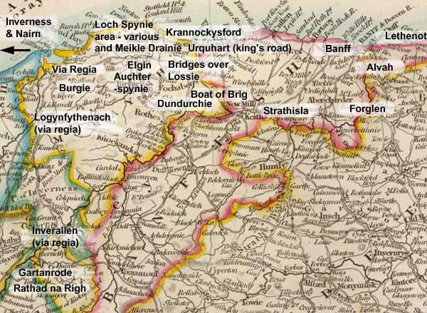
Elginshire
Loch
Spinie area
(New Spinie parish)
 |
| Places
mentioned in charters below. The course of the roads
is approximate. Loch Spynie is shown c.1750 from
the Military Survey. Blaeu shows it was once closer
to Kintrae. The dotted lines are those roads referred
to in Young's Parish of Spynie - see notes below.
Details of the "ancient causeway" can
be found on Canmore. |
From
OSA
Vol. 10, page 623
Page 624 In discussing the Palace of Spynie (residence
of the Bishops of Moray) and the former extent of Loch
Spynie he notes:
"But
although it is evident, that, at a period comparatively
not remote, the sea flowed into the space which
the lake now occupies, and covered, besides, a large
extent of land at each end of it; yet it is also
obvious, that, at a still more recent period, the
bounds of this lake were more limited than at present.
For, a few years ago, when the canal, which had
long been neglected, was cleaned out and enlarged,
a causeway was discovered, stretching from this
parish quite across the lake, in which there were
several passages for the water, each about 3 feet
wide, and covered by a thick flag-stone; and, upon
its appearance, a tradition was recollected, that
this causeway was called the Bishop's Steps, and
had been formed by his influence, for the accommodation
of the ministers of St. Andrew's, who officiated
also in the church of Ogueston, (since united to
Drainy,) both having been mensal churches before
the establishment of Presbytery. Bishop Falconer
told the author this; and that the Bishop's priest,
who officiated, had prayers in the forenoon in the
one, and in the afternoon in the other, and thereafter
his dinner in the Castle every Sunday. This causeway
was soon converted, by Mr Brander of Pitgaveny,
into a substantial road, by which a more direct
communication was opened between Elgin and the shore.
"
Note:
See Plan
of The Loch of Spynie and Adjacent Grounds, Moray
(1783) on Scotland's Places website. This shows
that work by the "Messrs. Branders" had
started on a road close to Lochside and Gilston
with a note saying "Said to be Steping stones".
West of this and just south-east of Unthank a road
is shown as "old road by the Long Steps from
Causie (Covesea) to Elgin with the "Long Steps"
just on the parish boundary. The map also shows
"steping stones said to be in this direction"
running NNE from Scarfbanks NJ236 664. |
On
page 626 he says:
 "The
boundaries of estates were early attended to. There
was a distinct march, dividing Spynie and Findrassie
from Kintrae and Quarrywood, by agreement, in 1226,
between Hugh de Moravia, and his brother the bishop,
and establishing the road to Sherriffmiln, Auchter-Spynie,
and Elgin, the march of property, declaring the
muirs to the east neutral ground." "The
boundaries of estates were early attended to. There
was a distinct march, dividing Spynie and Findrassie
from Kintrae and Quarrywood, by agreement, in 1226,
between Hugh de Moravia, and his brother the bishop,
and establishing the road to Sherriffmiln, Auchter-Spynie,
and Elgin, the march of property, declaring the
muirs to the east neutral ground."
Note: The wording here is different
from that covering what is presumably the same charter
mentioned in the Survey
of the Province of Moray (1882 edition, v.2,
p.112). There it talks of the highway that comes
from the castle of Duffus to Levenford (the Register
of Moray indicates this might be le neu ford -
charter 120, p. 132). It is difficult to identify
the course of the road nowadays though in general
terms it must have run from Elgin through Sherriff
Mill about one mile west of Elgin then by the line
of the minor road to the Duffus road which runs
between Finrassie and Kintrae, and then tending
over towards Duffus castle.
The Survey of the Province of Moray (v.2, p.117)
mentions another road leading from Duffus Castle
to the old church of Kintrae (Reg.
Mor. 211, p.273) and two roads from Spynie Palace
into Elgin (v.2, p.125) in a charter dating from
1566 (Reg.Mor.324,
p.395).
Robert
Young in his Parish
of Spynie (1871) mentions these roads with additional
comments that on the road leading from Elgin to
Duffus castle Loch Spynie was crossed on steps with
carts and horses skirting the loch, and that one
of the roads leading north from Bishopmill accessed
a ferry on the loch that went to Salterhill, and
another road (perhaps the easternmost road to Spynie
Palace mentioned above) passed the east end of the
loch to access Lossiemouth, Kineddar and Stotfield.
See
Plan
of The Loch of Spynie and Adjacent Grounds, Moray
(1783) on Scotland's Places website for additional
information on these. He also
mentions the Elgin to Forres highway that is shown
on Taylor and Skinner and the Military Survey -
see Alves.
Young also gives details of the bridge at Elgin
(1630) and later roads. |
Meikle
Drainy (Drainie parish)
Charter
348, page 399 (Reg.Mor) dating from 1545 refers to
common ways at Little Drainy or Salterhill, viz. descending
to the land of Littil Drainy called the Salterhill by
the common way which leads to the port of Mekill Drany,
and from there ascending by the common way which leads
to the lands of the Bishop of Elgin....
"descendendo a terris de Littil
Drany enunciates the Salterhill per communem viam
quae ducit ad portum de Mekill Drany, et exinde ascendendo
per communem viam quae ducit ad terras Episcopi de Etlis...."
Interpretation
It is not at all clear where the track approaching Salterhill
came from, perhaps Duffus castle or from the north; the
lands of the bishop are more likely to be those at Kinneddar
rather than on the south side of the loch at Spynie so
that after Salterhill the track probably ran towards Kinneddar.
Krannokysford
(Drainie and Urquhart parishes)
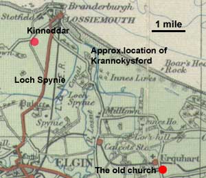 Item
289 in the Register of Moray (page 369) is a memorandum
dated 1368 noting that the bishop when walking from
Kinneddar to the church at Urquhart by the ford called
Krannokysford came across a sailing vessel in "his
water of Lossie" which led to a dispute (see Lachlan
Shaw, The
History of the Province of Moray, page 59 for details). Item
289 in the Register of Moray (page 369) is a memorandum
dated 1368 noting that the bishop when walking from
Kinneddar to the church at Urquhart by the ford called
Krannokysford came across a sailing vessel in "his
water of Lossie" which led to a dispute (see Lachlan
Shaw, The
History of the Province of Moray, page 59 for details).
Interpretation
With the placename lost and so many changes to the
coastline, the course of the Lossie and the former Loch
Spynie, one can do little more than note the approximate
location of the ford and of what would likely have been
a local track.
Auchterspynie
(Elgin parish)
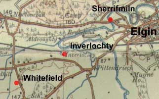 Charter
136 (page 149) (Reg. Mor) concerns the exchange
of the lands of Auchter Spynie for the land of Qwytford,
Innerlothy, the mill at Innerlothy, and Miltoun. Charter
136 (page 149) (Reg. Mor) concerns the exchange
of the lands of Auchter Spynie for the land of Qwytford,
Innerlothy, the mill at Innerlothy, and Miltoun.
Interpretation
It is unclear where Qwytford was though it may have
been near Inverlochty. Shaw says Auchter Spynie was
Sherriffmiln west of Elgin and suggests Whitefield for
the location of Qwytford (History
of Province of Moray, page 131).
Elgin
There are three references in the Register of Moray
of interest:
1. Via Regia
Charter
117, page 129 refers to the hospital called Domus
Dei which was sited in lands that stretched from the via
regia to the rivulet called Taok, along with lands called
Spetelflat next to the leper hospital of Elgin.
....Domus Dei de Elgin � quam fundavit
in terra a via regia usque ad rivulum de Taok in qua domus
situata est � cum terra que vocatur Spetelflat juxta domos
leprosorum de Elgin....
Interpretation
The
Taok is the Burn of Tyock just east of Elgin town centre
(see 6" OS map, Elgin,
sheet VII). The via regia would presumably continue
to the east.
2.
Road behind gardens
Charter
240, page 310 mentions a road on the south side
of Elgin running behind the gardens.
3.
Stratam Communem
Charter 242, page 313 refers to the stratam communem
which was probably the high street.
Kings's
Gate
A document in the Register of Arbroath (Vol.2, page
311, no. 383, dated 1497) refers to the Kyngis gait
in the town of Elgin.
Bridges
over the Lossie
The Register of Moray mentions
two bridges over the Lossie: one from Sankathel over
to Cranfinleth; the other named as the Bishop's Bridge.
Sankathel
- Cranfinleth
No.27,
page 19 This concerned a dispute between the bishop
and a Robert Fyndoc over land which Robert held on the
south side of the Lossie which he said was part of his
land of Kelleys held in feu-farm (requiring an annual
payment to the feudal superior) of the Domus Dei in
Elgin, and which the bishop said was part of his lands
of Tullibardine, obtained when he exchanged some lands
pertaining to the church of Munben. The dispute was
resolved with Robert passing over the lands south of
the Lossie as well as Kelleys. For this he was granted
a half davoch of land held by Archibald of Inverlochty
in the feu of Spynie.
The boundaries of this land are given as: "from
near the ridge on the east side of the bridge which
Archibald constructed over the Lossie from the eastern
side of Sankathel as far as Cranfinleth..."
a
proximo cundos* ex orientali parte pontis quem construxit
idem Archebaldus supra Loslyn ex orientali parte de
Sankathel usque Cranfinleth....
*Note:
Cundoys/cundois/cundos seems an obscure word. One source
gives the meaning as ridge crest (see here);
another as a conduit or watercourse (see here).
Given this location, either meaning could fit. See Logynfythenach
for another occurence of "cundoys".
Interpretation
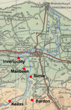 The
map shows the approximate location of some of the places
- Kelleys is Kellas with a Bardon on the other side
of the river, presumably Tullibardine, and Munden is
now Manbeen to the north of Kellas. Manbren is mentioned
in charter 39, page 33 and Tulibardyn as part of the
barony of Birnie in charter 457, page 421. The
map shows the approximate location of some of the places
- Kelleys is Kellas with a Bardon on the other side
of the river, presumably Tullibardine, and Munden is
now Manbeen to the north of Kellas. Manbren is mentioned
in charter 39, page 33 and Tulibardyn as part of the
barony of Birnie in charter 457, page 421.
Although Inverlochty and Spynie survive as placenames,
Sankathel and Cranfinleth do not, even on old maps so
that it is very difficult to say where this bridge might
have been other than that the mention of Spynie suggests
somewhere north or east of Elgin.
Bishop's
Bridge
No.
182, page 212. This contains a reference to the
bishop's bridge, which was probably near Bishopmill
on the north side of Elgin.
Burgie
(Rafford, Forres parishes)
Kinloss abbey was given the lands of Burgie,
adjacent to the original grant of Kinloss itself. In its
charters a via regia or king's highway between Forres
and Elgin and a ford called Blakeford that lies between
Burgyn (Burgie) and Ulern (Blervie) are mentioned.
From William the Lion they received "the lands of Burgie,
which lay on the north side of the king�s highway leading
from Forres towards Elgin, and adjoined their lands of
Kinloss, and the lands of Invereren..."
Records
of the Monastery of Kinloss, Society
of Antiquaries of Scotland, John Stewart, 1872,
page xi. See
page 108 for this charter which is no.2 - Carta donationis
Willelmi Regis totius terre de Burgin, dated pre-1180.
(See also Reg. Mor, page 454, and charter VI)
A
charter of confirmation from Alexander II, dated 1221,
referred to lands of Burgie that ran "from the
great oak in Malevin, on which Earl Malcolm caused a
cross to be marked, as far as the Rune of the Picts,
and from thence to Tubernacrumkel, and from thence by
the sike to Tubernafein, and thence to Runetwethel,
and from that by the rivulet which runs through the
marsh to the ford called Blakeford, between Burgy and
Ulern."
Records
of the Monastery of Kinloss, page xxvi. See page
112 for this charter which is no.5 - Carta
confirmationis Regis Alexandri II. Terre de Burgyn.
(See also Reg. Mor, page 456)
Interpretation
 |
| Map
of Burgie. The boundaries of the charter are difficult
to identify, as is "Blakeford". As noted
there was probably a track from Burgie to the abbey
or its grange and probably to Forres as well. The
via regia ran between Forres and Elgin. Based on
1" OS map of Lower Strathspey 1921. |
In
the above volume (page xxvi ff, also PSAS
Vol 2, 147), James Brichan discusses the boundaries
of this grant and places the Blakeford on the former
road from (Easter) Laurenceton to Forres and on the
boundary between Burgie and Blervie. St Laurence's fair
had been held in the vicinity which would have entailed
communication with Forres.
 |
| The
road between Forres and Elgin as shown on the Military
Survey map, c.1750. This must be very close to the
original line of the "king's highway"
as the Military Survey map shows several lochs east
of Easter Cloves. On one section it follows a parish
boundary. Based on half-inch OS map sheet 14, 1912. |
The
route taken by the King's Highway is shown on the map
and is that of the pre-turnpike which is likely to be
identical with or very close to the King's Highway.
It
should also be noted that there must have been a track
of sorts connecting the lands of Burgie with the abbey
itself, some three miles distant.
Dundurchie
(Rothes parish)
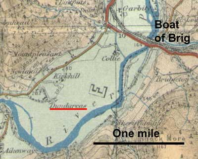
A
couple of Kinloss abbey charters refer to the gift of
the haugh of Dundurchis and fishing rights granted by
Peter de Polloch before 1203.
Records
of the Monastery of Kinloss,
charters
4 and 6, pages 112 and 115.
Interpretation
Dundurchie
is on the west side of the Spey a couple of miles NE
of Rothes and just over a mile from Boat of Brig where
there was a bridge in the middle ages. In theory they
could have used it as a staging point on journeys from
their Strathisla possessions but additional evidence
for this would be needed. Any journeys to Kinloss would
presumably be by a direct route to Elgin which the bridge
itself suggests.
Logynfythenach
(Edinkillie
parish)
Charter
37, page 30, (Reg.Mor) records that Alexander II and
the Bishop exchanged land in Finlarg (see Inverallan below)
for the forest of cawood and logynfythenach
and mentions
a via regia and a
semita.
Today
logynfythenach is known as Edinkille parish, about 6
miles south of Forres. A remnant of the name can be
seen in Logie. It is unlikely that the name refers to
the whole of the present day parish which is quite large
but rather to the vicinity of Logie from the Findhorn
to the brow of a ridge and north to the boundary of
the lands of Mundole.
The
charter reads: "The land of Logynfythenach which
is on the east side of Fyndarn as far as the nearby
brow of a ridge as that ridge extends from the east
side of the aforesaid land beginning above at the said
water and extending to the same water further down.
For the continuing support of a single chaplain to serve
God and to him and his successors we concede pasture
for six cows and eight oxen in our nearby forest on
the east side of the Fyndarn, namely between the king's
highway of Drumynd and Fyndarn and as the said highway
goes as far as the path that leads to Scloy above Fyndarn
and as the said highway goes to the bounds of Mundol....."
Terram de Logynfythenach que est ex orientali parte
de Fyndarn usque ad supercilium proximi cundoys* sicut
ille cundoys se extendit ex orientali parte predicte
terre incipiens superius a dicta aqua et extendens se
ad eandem aquam inferius ad sustentandum perpetuo ibidem
quendam capellanum solitarium Deo serviturum � cui et
successoribus suis ibidem Deo servituris concedimus
pasturam ad sex vaccas et octo boves in foresto nostro
proximo ex orientali parte de Fyndarn � scilicet inter
viam regiam de Drumynd et Fyndarn et sicut predicta
via regia extendit se usque ad semitam que vadit ad
Scloy super Fyndarn et sicut predicta via regia extendit
se usque ad diuifas de Mundol.....
*Note:
Cundoys/cundois/cundos
seems an obscure word. One source gives the meaning
as ridge crest (see here);
another as a conduit or watercourse (see here).
The ridge crest meaning seems more appropriate here,
although another occurence under "Bridges
over the Lossie" above could fit either meaning.
Interpretation
 The
ridge can not be identified although Drumine Hill is
a possibility and perhaps even the top of the steep-sided
valley in which the Findhorn runs; Drumynd is presumably
Drumine; Scloy somewhere near Mains of Sluie, and Mundol
the present-day Mundole. The
ridge can not be identified although Drumine Hill is
a possibility and perhaps even the top of the steep-sided
valley in which the Findhorn runs; Drumynd is presumably
Drumine; Scloy somewhere near Mains of Sluie, and Mundol
the present-day Mundole.
There
is a clear north-south orientation to the via regia,
running from Drumynd/Drumine to the boundaries of Mundol/Mundole,
with a track running to Scloy/Sluie. The Military Survey
map has a route from near Sluie past Altyre to Forres
that could approximate to the via regia. It is of course
very tempting to assume that it came from Forres and
ran down to the via regia in Inverallen below, perhaps
by Lochindorb.
While
there may be some truth in this, it is not that clearcut.
Apart from the Inverallen via regia there was an old
road running north from Cromdale to Forres, as well
as the Gartanrode of Edward's Itinerary, and a Rathad
na Righ near Loch Gartan. It is probably best to just
note these as separate stretches of road rather than
speculate too much about how they might be linked.
Inverallen
(Cromdale,
Duthil, Abernethy parishes - included
under Elginshire for convenience)
In charter
128 (page 142) (Reg. Mor.) there is a reference to
a via regia and a stone bridge in the vicinity of Finlarig,
a few miles south-west of Grantown.
The charter relates to a dispute between Augustine,
the lord of Inverallan and the Bishop about the land called
Fanymartach which the bishop said was part of his lands
of Fynlarg. Augustine ceded the said land:
"from the king's highway which is below the great
standing stones on the west side, and so descending by
the valley of the Fayny directly as far as the water of
Spey, and so towards the west as far as the next river
and a stone bridge..."
a via regia que est subtus magnos lapides
stantes ex parte occidentali � et sic descendendo per
vallem del Fayny directe usque ad aquam de Spee � et sic
transeundo versus occidentem usque ad proximum rivulum
et pontem lapideum
Interpretation
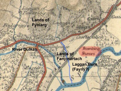 Fynlarg
is undoubtedly Finlarigg and there is a good possibility
that Fanymartach is nearby Muckrach. There are standing
stones nearby and at a first reading one would assume
the boundary went from the stones over to the River
Dulnan. The problem is the mention of the Fayny as even
the earliest OS maps do not show a stream between the
standing stones and the Dulnan. However, the Military
Survey map shows there was a stream (the Laggan Burn)
which must have been rechanneled as part of a drainage
scheme and which would fit the wording of the charter. Fynlarg
is undoubtedly Finlarigg and there is a good possibility
that Fanymartach is nearby Muckrach. There are standing
stones nearby and at a first reading one would assume
the boundary went from the stones over to the River
Dulnan. The problem is the mention of the Fayny as even
the earliest OS maps do not show a stream between the
standing stones and the Dulnan. However, the Military
Survey map shows there was a stream (the Laggan Burn)
which must have been rechanneled as part of a drainage
scheme and which would fit the wording of the charter.
As noted under Logynfythenach above it is unclear
how this relates to the Findhorn via regia, any route
that there might have been from Lochindorb, the old
road through Cromdale, the Gartanrode of Edward I, and
the Rathad na Righ mentioned by the Rev. W. Forsyth
in his In the Shadows of Cairngorm (chapter
XXV, page 205) that was near Tulloch south of
Nethy Bridge.
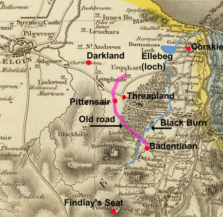
Urquhart
(Urquhart parish)
In the History
of the Religious House of Pluscardyn, (Rev.S R Macphail,
Edinburgh, 1881) there are a couple of references to roads
in the early 1500's - Urquhart and Pluscardine were merged
in 1454 which is why this is dealt with in the above book.
On
page 258 there is an extract from the old Rental of
c.1500 that mentions the marches of Urquhart, viz.
"The Marishes betwix the Baronie of Urquhart and the
Yrles lands of Murray on the West sid and South sid.
. . . passand oupwart on the West hand fra the Threpland
till Cormulan, and oup all the mouthe till Findlay's
Sete, and syne cummand doun agane on the sid neist Spey
till the heid of the Badyntenay, and sa cumand doune
the Blackburn till the taille of the Ellabege, and cumand
fra the taille of the Ellebege as the Geit ganges
till the heid of the Moss of the Quhit corss (note:
probably Corskie). A continuation to the hip thorn bush
on the king's road be that road throu Farnhead
Green of Darkland to the old thorn tree of Scotstonside."
The author adds "a note by Mr Rose informs us that
the old thorn still remained in 1803 on the public
road opposite to Pittinsair, dividing the woodfield
of Urquhart from Templeland and Kirkland of Lhanbride."
On
page 238 an indenture of 1524 refers to the marches
between the lands and barony of Urquhart and the lands
of Garmouth and Corskie, viz.
"It
is appointit accordit and finalie aggreit be ye said
partis concurrand in ane woce sa, yat ane corss of tre
is set wp be yaim and at yar command, at ye heid of
ye stripe rynnyng throwe ye said moss at ye west end
yareoff in ane grene gait cumand fra ane litill
loich callit ellebege and lyand ourthowet ye west end
of ye moss, And yarefra to discend northest linealie
be ane lyne to be ymaginit and drawin be ye sycht and
E, to ane poynt nuke or hillake on ye southsyd of ye
said moss betuex it and ye nowlandis of Corskie quhilkis
ye said robert wynnis out of mure on ye same southsyde
and yare ane othir corss of aike siclike is set and
infixit on ye southsyde of ye stripe rynnand throu ye
moss hard by ye said poynt and nuke, and yarefra to
discend siclik lynealie be ye sicht and E est to northin
throu ye moss to ane gryt erdfast qwhin stane lyand
on ye northest syde of ye grene gait passing
athowrt ye est end of ye said moss��"
Interpretation
The
map shows those places that are still identifiable,
although the references to roads are somewhat obscure.
The Geit near the Ellebege in the first extract
is clearly the grene gait of the second extract
and would be found near Corskie. It is unlikely to have
been more than a local track.
The
king's road of the first extract is difficult.
At first glance we would think it to be the presumed
via regia heading east from Elgin towards a crossing
of the Spey. Certainly at the time of the Military Survey,
c.1750, this had much the line of the present main road.
However, if we take the reference to Pittensair at face
value, the king's road may be an old road that ran past
Pittensair to Blackburn. To the north this road is shown
on older maps as running to Urquhart but may also have
had a branch up towards present day Darkland if this
is the Farnhead Green of Darkland of the extract - the
parish boundary runs in this direction. In any case
it is interesting to note that the parish boundary runs
for a couple of miles along the old Pittensair to Blackburn
road, indicating its age.
Banffshire
Alvah
From NSA
 |
| The
above map shows places mentioned in the commentary
on the charter in the Statistical Account, as well
as the likely course of the road - see also 6"
map, Banff sheet
X (NLS). It is not clear if it was local or
gave access to places like Turriff to the south
or Banff. The placenames containing "ford"
are indicative of routes, albeit local, and "slack"
was an old word that implied a pass or gap through
a hill. Based on OS half-inch map, Aberdeen and
Banff, 1912. With thanks to OS. |
Civil
History. Documents, Transactions, Etc.-There is
a long discussion of a charter of donation (to Coupar-Angus
abbey) dated 1314 - see here.
In a description of the boundaries of the land grant,
a road is mentioned 'ascendendo rivulem statent de lie
Claretwell usque ad viam ascendendo slakmethy
et inde descendendo per viam usque ad slacklethy
descendendo ad fontem et rivulem ejusdem usque ad redbank'.
In determining the boundaries he states: 'A little farther
up lies Knokkne, a place which still retains its ancient
name. From this we are directed to ascend the stream
which flows from Claret-well, until we come to the road
ascending to Slakmethy.
The Claret-well is still known by the same name, and
the stream which flows from it is only the upper end
of the Meirburn - circumstances which confirm the opinion
given in regard to the previously mentioned localities.
The road ascending southward to Slackmethy, (although
this name is now forgotten), can be no other than the
road ascending to the place now called Berryhillocks,
and the descent from thence to Slackmethy must be the
continuation of the same slack to the place now called
Kemplemire.' The charter also mentions a place called
Scurryford of which he says: 'Still farther up is Scurryfurd,
which is probably the place where an old road now crosses
the marshy hollow north-west of Bythestown, near the
Slacks.' These places are noted on the map.
Banff
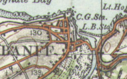 A charter of 1468 mentions a via regia and via maris
in Banff. (Registrum Episcopatus Aberdonensis, page
288)
A charter of 1468 mentions a via regia and via maris
in Banff. (Registrum Episcopatus Aberdonensis, page
288)
The
via maris is also mentioned in an Arbroath abbey charter,
dated 1323.
(Vol.1, charter 289, page 223)
Boharm
From OSA
V17, p358
 The
charter of Moray mentions a bridge over the Spey at this
location (Boat of Brig) - see 25" map, Banff
XIII.9. It is thought to have been of timber and the
foundation of the southern pier can still be seen. There
was an associated chapel of St Nicholas - "Ad receptionem
Pauperum transeuntium." Both are mentioned in 1232
but little else is known of them. The
charter of Moray mentions a bridge over the Spey at this
location (Boat of Brig) - see 25" map, Banff
XIII.9. It is thought to have been of timber and the
foundation of the southern pier can still be seen. There
was an associated chapel of St Nicholas - "Ad receptionem
Pauperum transeuntium." Both are mentioned in 1232
but little else is known of them.
NSA
Records and tradition tell of a very early bridge
(NMRS
record) over the Spey, near the confluence of the
Orchil. It was of timber and suitable for pedestrians
and horses. At its location the water is very deep on
the eastern side but it quickly becomes shallow and
tradition suggests that the deep water would have been
spanned by large lengths of timber while shorter ones
would serve to cross the shallower water, presumably
supported by pillars. It would be easy to repair if
damaged in a flood or suffered natural decay.
As the only bridge across the Spey for centuries
it was very important for the north. It has been thought
to have first been built by the Romans under Severus,
and existed at the time of the Reformation. In fact,
when the associated religious establishment was closed
this may have led to the neglect of the bridge until
it finally decayed or was swept away in a flood. Nothing
now remains.
A ferry-boat was established and the crossing point
became known as "the boat of bridge" while
farm names retained a reference to the former bridge
e.g. Upper Briglands. Just a few years ago a suspension
bridge has been erected at a cost of L.3500, along with
a toll house, by the Earl of Seafield and others. It
comes under the Banffshire Turnpike Act and a moderate
pontage is exacted.
Although the importance of the crossing is less since
the bridges at Fochabers and Craigellachie were built,
it is still very convenient to this neighbourhood.
Beside the bridge there was a religious establishment
called " the Hospital of St Nicholas at the Bridge
of Spey" and founded in the early 1200's for the
reception of poor travellers. (Some details are given
in the History of the Province of Moray, Lachlan Shaw,
Elgin, 1827, pages 20
and 424.);
Reg. Mor. Charters
106 - 113
Forglen
In charter
218 (page 279) (Reg.Mor) there is a reference to
a chapel dedicated to St Menimis or Monanus that lay
by the river Dovern and near which there was a high
road (altam viam).
"...and by this present charter of mine confirm
before God and the blessed Virgin Mary and dom Cristino
(title of respect, cf. Benedictine usage), chaplain
of the chapel of Saint Menimii, confessor, by the river
Duffern (Dovern) establish and provide for him (Christino)
four silver marks from the mill of Carnoussexth (Carnousie)
each year and the attached haugh which is called Dolbrech
by its right bounds, i.e. as a little syke on its western
side runs to a ditch at the head of the said Dolbrech,
and as another syke on the eastern side descends to
the high road..."
.....et hac presenti carta mea confirmasse
Deo et beate Marie Virgini et domino Cristino capellano
capelle Sancti Menimii confessoris super
ripam de Duffhern site servienti
et perpetuo capellano qui pro tempore fuerit ibidem
serviturus quatuor marcas argenti de molendino de Carnoussexth
singulis annis percipiendas
� et le haylch integre que vocatur Dolbrech per
suas rectas divisas � per illas scilicet sicut sica
parvula ex parte occidentali se extendit usque ad unam
fossam in capite dicte Dolbrech et sicut alia sica ex
parte orientali usque ad altam viam se descendit...
Interpretation
 |
| Possible
location of places named in the charter. See early
6" map, Banffshire
XVI, XVII. Based on OS half-inch map, Aberdeen
and Banff, 1912. With thanks to Ordnance Survey. |
The
location of the mill of Carnousie is unlikely to have
changed much, if at all, from the middle ages although
it is not actually of use in determining the location
of the "high road".
The
site of St Eunan's Chapel fits well with the charter
in as much as it lies by the river and has a haugh to
the east of it, named as Chapel Haugh on the old 6"
map. Eunan is a variant of Andoman, although it is unclear
if he is the same as St Menimis who has been identified
with St Monan.
Clearly
the "high road" would have been in the vicinity
but there is insufficient information to say where it
might have ran.
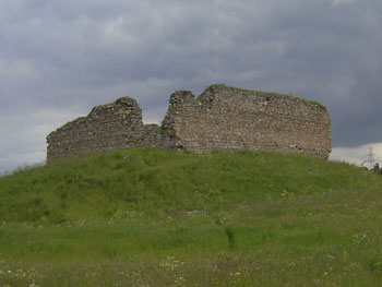
 Although
the above location fits well with the charter, there
is another chapel site a few miles upriver (Chapeltown)
that Andrew Jervise in Epitaphs and Inscriptions (Vol.1,
p234) suggests might be that of St Menimis or St
Monan. It too lies by the river and has low-lying land
nearby. There is also a nearby ford that could have
been associated with a "high road". Although
the above location fits well with the charter, there
is another chapel site a few miles upriver (Chapeltown)
that Andrew Jervise in Epitaphs and Inscriptions (Vol.1,
p234) suggests might be that of St Menimis or St
Monan. It too lies by the river and has low-lying land
nearby. There is also a nearby ford that could have
been associated with a "high road".
Which
of these is correct depends much on the identification
of the Menimis of the charter - Watson in The Celtic
Placenames of Scotland (chapter X) gives a good indication
of the wide variation in saints names.
Based
on half-inch OS map, sheet 14, 1912.
Strathisla
(Keith, Grange,
Rothiemay parishes)
 |
| Although
some names in the original charters are unidentifiable
today it is still possible using those names that
are identifiable as well as parish boundaries to
reconstruct the original grant of Strathisla. Based
on half-inch OS map, sheet 14, 1912. |
This was a grant made by William the Lion in 1196
of a large tract of land that today is represented
by the parish of Grange, the northern part of
Keith parish and part of Rothiemay parish (Barrow, Acts
of William II, p.383). Another charter relates to "certain
debatable lands between Strathilay and Deskfurd"
but need not concern us here.
Records of the Monastery of Kinloss,
page xi, See page 109 for
charter
no.3 - Carta Willelmi Regis de terra de Strathylaf
data Monasterio de Kynlos, dated 1195/96.
See charter 21 relating to Deskfurd
on page 146, viz. Charter by Robert, Abbot of Kinloss,
and Convent thereof, in favour of Alexander Ogilvy of
that Ilk, and of Finlater, of certain debatable lands
between Strathilay and Deskfurd. Dated 18 November 1537
Interpretation
Although no roads are mentioned, there would have been
quite a dense network of local routes as implied by
the large number of farms dependent on the grange and
also a route or routes to the abbey, some 30 miles away.
What
this route might have been is uncertain. One possibility
is by Keith and Fochabers to Elgin and then by the king's
highway to Kinloss, another is from Keith over to the
Boat of Brig where there was a mediaeval bridge and
then up to Elgin. Dundurchis near the river crossing
belonged to the abbey and would have afforded accomodation
on any journey though additional evidence for this would
be needed.
Bowmen's
Road (from Statistical Account for Grange parish)
OSA (V9, p555)
 |
| Bowmen's
Road, as shown on 6" OS Map (Banffshire, Sheet
XV - top left of centre). Based on half-inch
OS map, sheet 14, 1912. |
Antiquities.
- In referring to battles between the Scots and
the Danes in the 9th century he says that one of the
battlefields was on the south side of the Knockhill
"to which there leads a road from the encampments,
over the hill of Silliearn, called to this day, 'The
Bowmens Road.'
Note:
In fact, as Cosmo Innes notes in his Lectures on Scotch
Legal Antiquities, p.266,
a Bowman was a person hired to look after a tenant's
milk cows and their pastures. The road probably indicates
a route to these pastures.
Lethenot
(Gamrie parish)
 |
| Lethenot.
Based
on half-inch OS map sheet 15, 1912. |
A
charter of Alexander II confirms Kinloss in a grant
by Robert Corbett of three bovates of land between the
church of Gamrie and Troup, next to the sea, namely
Lethenoth. This lies about 7 miles east of Banff and
some 40 miles from Kinloss.
This land became the subject of a boundary dispute in
1537 which resulted in the boundaries being agreed between
Lethnot and Troup.
The document refers to certain "furds"
and to a high gate in the area.
The
references of interest are are follows:
"frae the lang furd where the
said Patrick begoutht to rid quhilk is the midmest furd
of the thrie furds ascendand up the hill of ffindon
and to the north side of the same on to the Cairnslaw
callit Clochtyne alias Teorie Clamchyne and frae thin
west to the high gate to the heid of Pollisdone and
in Commonty frae the said gate of the heid of Pollisdone
ascendand up the hill of ffindone on to the Law apon
the height of the same where there sal be put ane Staincross,
and frae than descendand down to the brek of the Moss
callit the Crossslacks as it is partit and merchit and
frae the said Cross-slaks south to the Todlaw as sal
be partit and merchit be the saids parties, swa that
it sal be leisum to the said Gilbert and his heirs to
laboure and mannure be west the said merches of Cross-slacks
and Todlaw with conies or ony other ways, and it sal
not be leisum to the said Gilbert nor his heirs nor
successors proprietars of the said Barony of Troup to
labour nor mannure the commond mure lying betwixt the
Halkden and the Todlaw..."
Records
of the Monastery of Kinloss,
page 143. Decreet
anent the Merches betwyx Lethnot and Troup. (A.D. 1537.)
Interpretation
Although
not all the placenames can be identified it does not
matter too much as the high gate must have been north
of the Hill of Findon; however, it is not clear if it
ran down Powies Den (Pollisdone) or ran in an east-west
direction.
It
is possible that the "furds" referred to are
not fords across a stream but are an old Scots word
for burn or brook as noted by Johnston in The
Placenames of Stirlingshire, p.19. This would fit
the meaning of the text better where they are said to
ascend the hill - as the map shows, streams do descend
from the hill of ffindon.
Old
Cullen
Carta Thome de Petkarn domini eiusdem (Register
of Arbroath Vol. 2, Page 48, charter 51)
This charter of 1413 refers to:
..a toft lying in the villa of Colly in the street called
Kyrkgait on the south side of the same street between
the monastic lands on the east side and the croft called
Castailgait on the west side…..
vnum
toftum jacens in villa de Colly in vico qui dicitur
Kyrkgait ex parte australi eiusdem vici inter terram
. . . monachorum ex parte orientali . . . Et croftum
quod dicitur Castailgait ex parte occidentali . . .
Interpretation
Miller in Arbroath and Its Abbey (1860), page 203 suggests
Colly might be Cullen. There are earlier charters for
Innerculayn (vol.2, no.5, p.5/6) and Kolly (vol. 2,
no. 11. p.10) so this may well be correct though the
name refers to Old Cullen and not the new town of Cullen
which dates from 1824 - see NMRS
record. Old Cullen did have a Kirkgait and a Castlegait.
Itinerary
of Edward I

Edward visited Moray twice, in 1296 and 1303. The routes
he and his army took are listed and discussed in two
books, viz:
Itinerary
of King Edward the First throughout his reign, Henry
Gough, (see in particular Vol. II)
Edward
I. of England in the north of Scotland.
James Taylor, Elgin 1858.
See also W Douglas Simpson who discusses the siting
of castles in relation to routes between the eastern
lowlands and Moray in "The
Early Castles of Mar", PSAS, Vol 63, and shows how
Edward was using well-established routes into Moray.
The
route taken in his 1296 campaign can be seen on the
map, and his activities are discussed in Taylor's book
(chapter 4). It is not clear if there were via regias
between the main centres - these need not imply made
roads but allowed free passage along a beaten track.
Taylor suggests that the approach from the Spey to Elgin
was by a via regia - while likely enough we only have
one reference to a via regia just to the east of Elgin
over the Taok so it may be an assumption on his part.
He
gives some interesting details of the crossing point
of the Spey (page 86) which was an ancient fording point
just north of Fochabers. Leaving aside the possibility
that the Romans used this ford from their putative camp
at nearby Bellie, it was used by Malcolm Canmore and
Alexander I in military campaigns, by Cromwell and Montrose,
and by Cumberland prior to Culloden.
 On
leaving Elgin for Rothes, Edward himself went south
by Invercarrach (Taylor, chapter 7) which is about 3
miles north of Cabrach, and then Kildrummy castle. At
Rothes he sent three groups into Badenoch, probably
to ascertain if there were remnants of Comyn resistance.
Taylor suggests they would have travelled to Ruthven,
Lochindorb, Loch na Eilan near Aviemore, and possibly
Castle Roy at Nethy-bridge or an earlier fortification
at Castle Grant. The bishop of Durham was sent south
"by another way" which Taylor suggests was
to the castle of Strathbogie, either by Botriphnie etc,
or "by the bridge of St Nicholas across the
Spey at Inverorkel, and thence by Mulben, Strathisla,
Rothiemay, and Ferendraught". On
leaving Elgin for Rothes, Edward himself went south
by Invercarrach (Taylor, chapter 7) which is about 3
miles north of Cabrach, and then Kildrummy castle. At
Rothes he sent three groups into Badenoch, probably
to ascertain if there were remnants of Comyn resistance.
Taylor suggests they would have travelled to Ruthven,
Lochindorb, Loch na Eilan near Aviemore, and possibly
Castle Roy at Nethy-bridge or an earlier fortification
at Castle Grant. The bishop of Durham was sent south
"by another way" which Taylor suggests was
to the castle of Strathbogie, either by Botriphnie etc,
or "by the bridge of St Nicholas across the
Spey at Inverorkel, and thence by Mulben, Strathisla,
Rothiemay, and Ferendraught".
 |
| Places
visited by Edward on his campaigns |
| 1296
Gough, page 143 |
| 20
July |
Aberdeen |
27 |
Elgin |
| " |
Kintore |
28 |
Elgin |
| 21 |
Kintore |
29 |
Rothes |
| " |
Lumphanan
(then via Fyvie & Turiff) |
30 |
Invercarrach
south of Dufftown |
| 22 |
Banff |
31 |
Invercarrach |
| 23 |
Cullen |
1
August |
Kildrummy
' |
| 24 |
The
Moor |
" |
Kincardine-
O'Neil |
| 25 |
Rapenache |
2
|
Kincardine
in Mearns and south thereafter |
| 26 |
Elgin
|
|
|
| 1303
Gough,
page 228 |
| 28
Sept |
Aberdeen |
6 |
Rathven |
15 |
Kinloss |
24 |
Lochindorb |
2 |
Gartanrothe |
11 |
Elgin |
| 29 |
|
7 |
Rathven |
16 |
Kinloss |
25 |
Lochindorb |
3 |
Lochindorb |
12 |
|
| 30 |
|
8 |
Rathven |
17 |
Kinloss |
26 |
|
4 |
Lochindorb
Kinloss |
13 |
Fettercairn
Kinloss |
| 31 |
|
9 |
Elgin |
18 |
Kinloss |
27 |
|
5 |
|
14 |
Kinloss |
| I
Oct |
|
10 |
Elgin |
19 |
Kinloss |
28 |
Gartanrode |
6 |
Kinloss
Mortlach |
15 |
Kinloss |
| 2 |
|
11 |
Elgin |
20 |
Kinloss |
29 |
|
7 |
Kildrummie |
16 |
Dundee
and south thereafter |
| 3
|
Banff |
12 |
Elgin |
21 |
Kinloss |
30 |
Gartanrode |
8 |
Kildrummie |
|
|
| 4 |
Banff |
13 |
Elgin
Kinloss |
22 |
Kinloss |
|
Kinloss |
9 |
Kildrummie |
|
|
| 5 |
Cullen |
14 |
Kinloss |
23 |
Kinloss |
1
Oct |
Lochindorb
Gartanrothe |
10 |
Coghresk
Kinloss |
|
|
The campaign of 1303 followed much the same routes as
the earlier campaign (Taylor, chapter 11). The excursions
to Lochindorb and Gartanrode are interesting because
of the problem alluded to under Inverallan above, viz.
if the route from Kinloss/Forres was by the via regia
mentioned in Edinkillie parish and if this was the same
as the via regia of Inverallan and indeed the old road
running north from Cromdale.
As
a name Gartanrode is interesting as it suggests a road.
However, Louise Yeoman in the community newsletter BOG
Standard, Winter 2012 (page 18) suggests that it
may have been a fortified site near Boat of Garten called
Petriny Motte (on Mains of Garten farm) or effectively,
the rath of Gartan, where "rath" means a fort.
This was a Comyn stronghold and would give a good reason
for Edward to come here. While this is a more likely
explanation for the "rode" of Gartanrode there
does seem however to have been a road in this area -
this was the Rathad na righ or king's road as mentioned
by the Rev. W. Forsyth in his In the Shadows of Cairngorm
(chapter
XXV, page 205).
Taylor
refers to forays to more northerly and western districts
by detachments of the army though not accompanied by
Edward himself. He suggests that Urquhart castle (at
the north end of Loch Ness) and Inverlochy castle (near
Fort William) were taken as well as Beaufort castle
near Beauly, followed by attacks on the castles of Dingwall
and Cromarty. All these forays imply routes.
Top
|