Ettrick
 In
1235 or 1236 Alexander II granted extensive lands in
Ettrick to Melrose. The charter reads: "our whole waste
from the river of Ethryc ascending by the rivulet of
Tymeye, as far as the bounds of Nigell de Heryz - thence
ascending by the watershed between Ethric and Glenkery
to the borders of Esckdal and Ethric as far as the mountain
called Vnhende (identified as Wind Fell in OPS), and
thence eastwards along the watershed between Annandale
and The Forest to the head of Rodanoch, and thence eastward
by the watershed between the Forest and the land of
Thomas de Hay, to the head of Copthra-werisclouch, and
thence descending to the greater lake (doubtless St
Mary�s Loch), and thence ascending by the lake to its
head, and thence ascending southward to the rivulet
of Whythhop, and thence ascending as far as Thyrlstangate,
and along the same road to the head of Wulfhop, and
thence descending by a sike to the rivulet of meikle
Thyrlestan, and by the same rivulet descending to the
river of Ethric, and by that river ascending as far
as Tymeymuth."(transl.
from Origines Parochiales Scotiae) In
1235 or 1236 Alexander II granted extensive lands in
Ettrick to Melrose. The charter reads: "our whole waste
from the river of Ethryc ascending by the rivulet of
Tymeye, as far as the bounds of Nigell de Heryz - thence
ascending by the watershed between Ethric and Glenkery
to the borders of Esckdal and Ethric as far as the mountain
called Vnhende (identified as Wind Fell in OPS), and
thence eastwards along the watershed between Annandale
and The Forest to the head of Rodanoch, and thence eastward
by the watershed between the Forest and the land of
Thomas de Hay, to the head of Copthra-werisclouch, and
thence descending to the greater lake (doubtless St
Mary�s Loch), and thence ascending by the lake to its
head, and thence ascending southward to the rivulet
of Whythhop, and thence ascending as far as Thyrlstangate,
and along the same road to the head of Wulfhop, and
thence descending by a sike to the rivulet of meikle
Thyrlestan, and by the same rivulet descending to the
river of Ethric, and by that river ascending as far
as Tymeymuth."(transl.
from Origines Parochiales Scotiae)
OPS, Volume I, page
260
Lib. De Melros, pps 234,
235 and 666, 667
Monastic
Annals of Teviotdale, page 273
Identification
 |
| Looking towards Ettrick Forest
- Wind Fell on the left |
From the map the various places
in the charter can be easily seen. Ethryc and Tymeye
are the Ettrick and Tima and Glenkerry still exists
as a place name. The OPS identifies Vnhende as Wind
Fell. More difficult is Rodanoch but there is a Rodono
Hotel beside St Mary�s Loch and the NMRS have a record
for Rodono
Chapel just south of Loch of the Lowes. The New
Statistical Account notes that the whole area of Megget
used to be known as Rodonno. Copthra-werisclouch is
Cappercleugh and the Whitehope Burn runs into Loch of
the Lowes near Tibbie Shiels Inn (other OS maps show
part of it as Crosscleugh Burn). Wolfhope and Wolfhope
Burn are shown on the old 6" map (Selkirkshire
XVIII). Finally Thyrlstan must be connected with the
Thirlestone place names shown on the map.
Despite the name Thyrlstangate,
it is unlikely given the occurrence of another Thirlstane
near Lauder, that it refers to a "stone gate" but rather
that it was the road to Thyrlstan. The name itself refers
to a "stone with a hole in it" (Nicolaisen, Scottish
Place-names, John Donald, p.34) but there is no record
of such a stone in the area.
From the charter one would
think it easy to identify the road but there are difficulties.
Whitehope Burn is clear enough and the charter suggests
that from it one could easily reach Thyrlstangate. It
is tempting to identify the road with The Captain�s
Road (presumably used by reivers and drovers at a later
date) which leads over to Hopehouse but its course does
not accord with the reference to Wolfhope.
A strict reading would take
the Thyrlstangate over by Coom Law to the head of the
Wolf Burn from where it must have continued to Thyrlstan,
although it seems a circuitous route. At this point
the boundary leaves the road following a sike which
may have been Kings Grain which leads to Hopehouse Burn
and from there to the Ettrick. This however would require
the identification of Hopehouse Burn as Thirlstane Burn
which the early 6" maps show on the other side of Thirlstone
Hill.
As to the purpose of the road
and when it originated there are too many uncertainties
to say anything useful other than that it connected
St Mary's Loch and the valley of the Ettrick. Once Melrose
started to develop the area it is easy enough to imagine
that they would have travelled down the Ettrick to Selkirk
and then to Melrose a few miles further on.
Selkirk
 In
a charter dated between 1113 and 1124 David I, before
he became king, founded an abbey at Selkirk. The site
eventually proved unsuitable and was moved to Kelso
in 1128. In the charter detailing the boundaries of
the territory granted to the monks, mention is made
of a road running between the castle and the place where
the abbey was to be built. In
a charter dated between 1113 and 1124 David I, before
he became king, founded an abbey at Selkirk. The site
eventually proved unsuitable and was moved to Kelso
in 1128. In the charter detailing the boundaries of
the territory granted to the monks, mention is made
of a road running between the castle and the place where
the abbey was to be built.
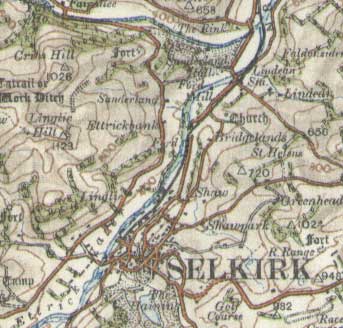
From a close analysis of the
charter, R P Hardie (Roads of Mediaeval Lauderdale)
was able to determine the site for the abbey as very
near the old church of Lindean (NT 483 308), 2 miles
north of Selkirk. He was also able to determine the
likely course for the road, given that the castle was
sited just south of the town centre near the Haining
(NT 4700 2810).
Sometime after this they were
granted the lands of Lesmahagow and it appears that
they built a bridge over the Ettrick to give easier
access to the Minchmoor road along which they could
reach Lesmahagow. A charter of Alexander II dated to
1234 refers to land on both sides of the Ettrick granted
on condition that the abbey would maintain the bridge,
as well as to pasture on Minchmoor. This was at Bridgelands,
just under 2 miles north of Selkirk and it is interesting
to see that the parish boundary for Selkirk includes
a detached portion of land on the other side of the
river at this location.
R P Hardie, Roads of Mediaeval
Lauderdale, 1942, Chapter 1
OPS, Volume I, Selkirk,
page 267
Monastic
Annals of Teviotdale, page 109
Liber
S Marie de Calchou (for David I see page 3 and 6,
Alexander II page 309)
Top
|

