|
KELSO ABBEY
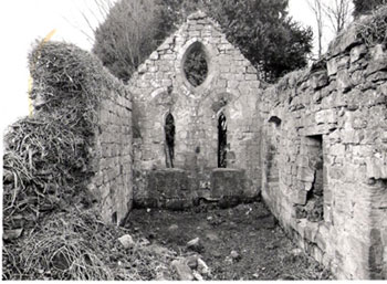
Keith (Humbie)
In the time of Malcolm IV, the church of Keith and
some lands were granted to Kelso Abbey. The church is
now a ruin and is sited near Keith Marischal in what
is now Humbie parish. Several charters relate to this
grant and two are given below as they contain most of
the placenames defining the lands.
Charter 85
"..with all that land and all woodland
from the southern part of the river which runs next to
the church, i.e. by the said river to the Kyrckeburn,
and from there to the road which goes to Haddington,
and from there to Kyrnestrother and then to Reavedene,
and from Reavedene as far as the aforesaid river running
next to the church; and that land from the east side of
the road next to the church as far as the summits of the
hills and the oak tree which stands above the river."
 |
| The road to Haddington |
"Cum tota illa terra, et toto nemore
ab australi parte rivuli qui currit juxta ecclesiam;
scilicet, per predictum rivulum usque ad Kyrckeburn
; et inde usque ad viam quae vadit ad Hadyngton;
et inde usque ad Kyrnestrother, et de Kyrnestroder usque
in Reavedene, et de R. usque ad praefatum rivulum qui
currit juxta ecclesiam; et illam terram ex orientali
parte viae juxta ecclesiam usque ad supercilium
montis, usque ad quercum quae est super rivulum."
Monastic Annals of Teviotdale, page
139
L. de Calchou charter
85, page 63
Charter 87
"...with all that land
and all woodland from the southern part of the river
which runs next to the church, i.e. by the said river
next to the church to the Kyrcheburne and from the Kyrcheburne
ascending to the road from Haddington which is
beside the dwelling of Roberti Coth from the northern
part, and by that road as a furrow has been drawn
and crosses placed as far as Crosforde, and so by the
ditch of Crosforde ascending by a furrow made as far
as two great stones then more or less transversely across
waste land to the east side of a large camp and from
that as a furrow has been drawn to another camp, then
transversely to stanilawes and from there by a furrow
to a small stone bridge, and from that by a ditch
down to chirnestrother and by the great ditch of chirnestrother
descending northwards to Revedene, and by Revedene as
far as the aforesaid stream that runs beside the church.."
"Cum tota
illa terra, et tote nemore ab australi parte rivuli
qui currit iuxta predictam ecclesiam; scilicet, per
predictum rivulum iuxta ecclesiam usque in Kyrcheburne
et a Kyrcheburne ascendo usque ad viam de Hadington
que est iuxta domus Roberti Coth ab aquilonari parte
et per eandem viam de Hadington sicut sulcus
trahitur et cruces posite sunt usque in Crosforde et
sic per sicam de Crosforde ascendo sicut sulcum trahitur
usque ad duos magnos lapides et ab illis duobus lapidibus
in transversum cujudam vacelli usque ad orientale latus
unius magne chestre et ab illa sicut sulcum trahitur
usque ad aliam chestram et in transversum usque stanilawes
et a stanilawes sicut sulcum trahitur usque ad parvulum
pontem lapideum et sic per sicam descendentem ab
illo ponte usque in chirnestrother et per magnam
sicam de Chirnestrother versus aquilonem descendentem
usque in Revedene et per Revedene usque ad predictam
rivulum qui currit iuxta ecclesiam prenominatam.."
L. de Calchou charter
87, page 65
Interpretation
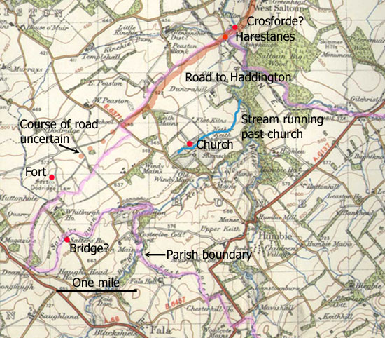 Older
maps show a stream south of the church running up to
the Humbie Water which on this interpretation would
be the Kyrckeburn. Following this river north, one reaches
the point where the present day road (heading directly
for Haddington) crosses the river at Milton Bridge.
As the Harestanes were nearby this may well have been
the Crossforde of the charters and this road, or its
precursor, that of the charters. Older
maps show a stream south of the church running up to
the Humbie Water which on this interpretation would
be the Kyrckeburn. Following this river north, one reaches
the point where the present day road (heading directly
for Haddington) crosses the river at Milton Bridge.
As the Harestanes were nearby this may well have been
the Crossforde of the charters and this road, or its
precursor, that of the charters.
 |
| Dodridge Law |
From here it is interesting to see the parish boundary
follows this road south-eastwards for about two miles
and at one point runs very near the fort at Dodridge Law.
The charter then refers to another fort which is not identifiable
unless there was a fort on Mar Law, or Whitburgh refers
to an early camp other than that at Dodridge Law.
 |
| Salters Bridge with
ford |
From the second camp the boundary ran to "stanelawes"
and then to a small stone bridge. The Salters' Bridge,
or a precursor, could be a candidate for this. The boundary
then goes to Kyrnestrother then northwards by a ditch
to Reavdene from where the stream running to the church
is reached.
While this interpretation is not absolutely certain,
it does tie in to a camp (Dodridge Law), the Harestanes,
and a nearby river crossing with an early road (shown
by its following the parish boundary) heading directly
towards Haddington.
It is not clear what the purpose of the road beside
the church was.
Innerwick
parish
A charter of 1190 details the rent of
forest and pasture lands to Kelso adjacent to lands
they already held in Innerwick. The boundary was: "As
the stream of Edwardescloth falls into the Bothkil next
to Elziehaleth, and so as the Bothkil descends to the
Wood of Fulhope, running obliquely by the marches of
Ellum to Mammet, and by Mammet as far as the northern
part of Witslede, and from Witslede obliquely as far
as Edwardescloth where it falls into the Bothkil."
" Sicut rivulus de Edwardescloth
cadit in Bothkil juxta Elzieshaleth ; et ita sicut Bothkil
descendit ad Buccam de Fulhope, in transversum per divisas
de Ellum usque ad Mammet ; et per M. usque ad acquilonarem
partem de Witslede ; et ab W. in transversum usque in
Edwardescloth ubi cadit in Bothkil."
Monastic Annals of Teviotdale, page
140
L. de Calchou charter
248, page 205
Another grant by Walter, the king's steward granted
them lands that he held in Innerwick, namely:
"...to Bothkil, ascending by the stream which falls
into Scoulande, as far as Scoulandesheved where a furrow
has been drawn out, and by that furrow as far as the
road which leads from Risilbrig towards Innerwic,
and so by that road eastwards to a certain fosse,
then descending to Meldrescloes-heved, and so by the
stream from Meldrescloes-hevid all the way downhill
as far as Mammet and so to the Wood of Estfulhope; and
so ascending westwards next to the boundaries of Ellum
and Risilbrig to Westfulhope, Withedre and Bothkil as
far as the aforesaid river which falls from Scouland."
"a Bothkil, ascendendo per rivulum
qui cadit a Scoulande, usque ad Scoulandesheved, ubi
sulcus trahitur ; et per illum sulcum usque ad viam
quae tendit de Risilbrig versus Innerwic ; et sic
ab ilia via versus orientem, usque ad quandam
fossam ; et sic descendendo usque ad Meldrescloes-heved
; et sic per rivulum de Meldrescloes-heved, semper descendendo,
usque in Mammet; et sic usque ad Buccam de Estfulhope
; et sic ascendendo versus occidentem juxta divisas
de Ellum et de Risilbrig, usque in Westfulhope, et in
Withedre, et in Bothkil, et usque in pradictum rivulum
qui cadit de Scouland."
Monastic Annals of Teviotdale, page
140
L. de Calchou charter
247, page 203
Interpretation
Click on map for larger image
- based on 1926 1" map for Dunbar
& Lammermuir,
with thanks to Ordnance Survey
 Blaeu's
map of the Merse
shows a Rysybrigs close to Cranshaws church and just
downstream from the confluence of the Whiteadder and
the Bothwell water. The old 6"map (Berwickshire,
sheet IX) shows a Rise Lea just south of Harehead
farm nearby which is probably the Risilbrig of the charter.
This means the road must have ran from here up to Innerwick. Blaeu's
map of the Merse
shows a Rysybrigs close to Cranshaws church and just
downstream from the confluence of the Whiteadder and
the Bothwell water. The old 6"map (Berwickshire,
sheet IX) shows a Rise Lea just south of Harehead
farm nearby which is probably the Risilbrig of the charter.
This means the road must have ran from here up to Innerwick.
That this is likely is shown by it being in the area
covered by the charters. Although a number of the placenames
have been lost, the old 6"map (Haddingtonshire,
sheet 16) shows two streams running east to join
the Bothwell: Hazelly Cleugh (NT6566) and Elsiecleugh
(NT 6466). One or other must be the Elziehaleth of the
charter. The mention of Ellum and the Whiteadder shows
that the lands were in the south part of Innerwick parish
which is bounded on its west side by the Bothwell. The
Mammet of the charters is probably Monynut.
Although the charters do not contain enough detail
to determine the exact course of the road, its general
course is clear. It may have followed the route shown
on the Military Survey that ran up by the Bothwell Water
to the west side of Bransly Hill then north-east to
Innerwick. Alternatively, a route is shown on other
maps about one mile east of this that kept to the high
ground between the Bothwell and Monynut Waters
Spott parish
Bothkil
This item has been moved
from Berwickshire.
Earl Gospatric in the reign of Malcolm
IV (1153-1165) gifted the church of Fogo as well as
land and pasture at Bothkilscheles to Kelso Abbey. The
charter says "By those bounds viz. from the source
of the Kaldwell, all the way to the uninhabited land
where this stream descends, and from there as that river
falls into Bothkil; and thence as Bothkil falls into
the Whitheddre; and then from the Witheddre to the great
road which goes beyond Spertildoun, and by that road
all the way to the source of the Kaldwelle; and to have
common pasture between them and the shielings of my
men of Pinkerdun."
In
case my translation is faulty, the original text is
given here - however, the references to the roads are
clear enough. "Per istas divisas, viz. de sursa
fontis de Kaldwelle, usque in vacellum in quo rivulus
praedicti fontis descendit, et ab illo vacello sicut
rivulus ille cadit in Bothkil; et inde sicut Bothkil
cadit in Whitheddre, et post de Witheddre usque ad viam
magnam quae vadit ultra Spertildoun, et per eandem
viam usque in praedictum fontem de Kaldwelle;
et communem pasturam inter eos et scalingas hominum
meorum de Pinkerdun."
Monastic
Annals of Teviotdale, page 128,
L. de Calchou charter
72, page 54; Angus
Graham, More
Old Roads in the Lammermuirs, PSAS,Vol
93 (1959-60), pps 217-235
Identification
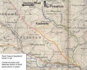 Although
the Monastic Annals, following the listing of charters
in the Liber Kelso, deals with the grant of Bothkilscheles
under Fogo, it is actually in Spott parish in East Lothian.
The Bothkil is Bothwell Water, Witheddre is the Whiteadder,
Spertildoun is Spartleton and Pinkerdun is Pinkerton,
a couple of miles NW of Innerwick and about 6 miles
north of the Bothwell Water (the shielings would presumably
have been closer to Spartleton on high ground). The
difficulty is the Caldwell which does not appear on
early maps, although there is a suggestive Caldercleugh
running into the Bothwell Water. Although
the Monastic Annals, following the listing of charters
in the Liber Kelso, deals with the grant of Bothkilscheles
under Fogo, it is actually in Spott parish in East Lothian.
The Bothkil is Bothwell Water, Witheddre is the Whiteadder,
Spertildoun is Spartleton and Pinkerdun is Pinkerton,
a couple of miles NW of Innerwick and about 6 miles
north of the Bothwell Water (the shielings would presumably
have been closer to Spartleton on high ground). The
difficulty is the Caldwell which does not appear on
early maps, although there is a suggestive Caldercleugh
running into the Bothwell Water.
There is however a strong likelihood that the boundaries
of the grant are shown on early maps as a detached portion
of the parish of Spott (see Forrest
1799 - NLS site). This shows the boundary of the
detached portion of Spott running from a road down Calder
Cleugh to the Bothwell, then following this as far as
the Whiteadder. It follows the Whiteadder up a little
way and heads up over a hill where it joins a road running
up from Bothwell past Spartleton Hill as far as Caldwell
Cleugh.
Although Forrest does not show a road from St Agnes
to his other road, he does have a short length running
from the Whiteadder to Hainshawside on the parish boundary.
Ainslie's
map of 1821 shows a road on this boundary running
up to the other road. On both maps the road from this
point onwards runs up to Calder Cleugh and beyond, following
parish boundaries for several miles.
 |
| Bothwell Hill near Spartleton |
The
best fit with the wording of the mediaeval charter is
to assume that the Spartleton road did run from the
Whiteadder near St Agnes and followed the above parish
boundary, not only up to Calder Cleugh, but for another
three miles, to the vicinity of the suggestively named
Stoneypath (Angus Graham refers to a charter of 1458
confirming an earlier charter of 1359 that mentions
Stoneypath). For a road to follow a parish boundary
is a sign of great age and it is quite noticeable that
it has the characteristics of a ridgeway, i.e. follows
Spartleton Edge.
It
is not clear what the purpose of the road was. The complicated
history of the various tracks in this area as detailed
by Angus Graham in his paper "More Old Roads in
the Lammermuirs" suggests that at certain periods
it could have been used to reach Haddington or Dunbar
to the north and Duns to the south. It certainly has
a very strong north-westerly alignment suggesting a
route up the valley of the Whiteadder through Ellemford
that would allow access to Haddington and elsewhere
in East Lothian.
 |
| Trapain Law |
Nor
is it clear when the route might have developed. It
is well aligned with Trapain Law and with early Anglian
settlements like Whittinghame but these are too speculative
to be considered in the light of the existing evidence.
MELROSE ABBEY
Stenton
Parish
A charter by Waldeve, Count of Dunbar, dating from the
reign of William I (1165-1214) gave Melrose some land
in the Lammermuirs. The boundaries ran: "from Baldred's
Stane by the highway to Eslingcloh and thence downwards
as Heslingcloh falls into Bothyil and thence as far
as the marches of Inerwic." (Fraser)
"scilicet, de Baldredestan per altam
uiam usque ad Eslingcloh et inde deorsum sicut Heslingcloh
cadit in Bothkyl, et inde usque in diuisas de Inerwic..."
Liber Melros, Charter
76, page 67; Frasers of Philorth, Alexander Fraser,
1879, page
12
Interpretation
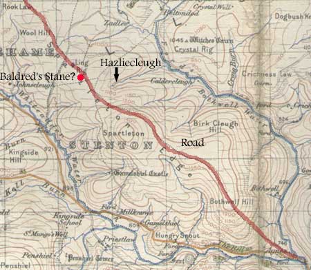 There
is a strong likelihood that this territory lay just
north of the Bothkil grant immediately above. There
is a Hazliecleugh running down from the road that runs
along Spartleton Edge and a standing stone at Ling Rig
(NMRS
record) that may be the Baldred's Stane of the charter.
The boundaries would have run from the stone along the
road to the headwaters of the Hazliecleugh, followed
this down to Bothwell Water and then upstream, presumably
to the vicinity of Yadlee or Beltondod and so back to
the standing stone. The only difficulty with this interpretation
is the mention of the bounds of Innerwick as the Bothwell
Water itself forms the boundary, although the wording
may be relevant to the situation at that time. There
is a strong likelihood that this territory lay just
north of the Bothkil grant immediately above. There
is a Hazliecleugh running down from the road that runs
along Spartleton Edge and a standing stone at Ling Rig
(NMRS
record) that may be the Baldred's Stane of the charter.
The boundaries would have run from the stone along the
road to the headwaters of the Hazliecleugh, followed
this down to Bothwell Water and then upstream, presumably
to the vicinity of Yadlee or Beltondod and so back to
the standing stone. The only difficulty with this interpretation
is the mention of the bounds of Innerwick as the Bothwell
Water itself forms the boundary, although the wording
may be relevant to the situation at that time.
In general terms, the charter confirms the continuation
of the road along Spartleton Edge.
Whittinghame
Parish
Ricardisrode
There is an interesting reference to a named road in
the parish of Whittinghame that also forms the parish
boundary for some length. The road is Ricardisrode and
is mentioned in a charter dating from around 1230 in
which Melrose were given land on the east part of Fastenei
that ran: "from the ford of Fastenei by the road
which is called Ricardisrode as far as the head of Kelnemade,
and from there by the stream which runs into Kelnemade
as far as Witedre..."
"Totam scilicet terram illam que
est in orientali parte de Fastenei infra has divisas,
a vado scilicet de Fastenei per viam que dicitur Ricardisrode
usque ad caput de Kelnemade, et inde per rivulum qui
currit in Kelnemade usque in Witedre..."
Liber Sancte Marie de Melros, Charter
215, page 193; Angus
Graham, More
Old Roads in the Lammermuirs, PSAS,Vol
93 (1959-60), pps 217-235
Interpretation

The charter describes a grant of land about four miles
north-west of Longformacus on what is now a route leading
to Haddington. Fastenei is Faseny, Kelnemade is the
Killmade Burn and Whitedre is the Whiteadder. Following
Graham, the ford was over the Faseny Water at NT 637615
from which point the parish and county boundary to the
east no doubt shows the course of Ricardisrode for about
one and a half miles where the headwaters of the Killmade
Burn are reached. The Killmade Burn then runs NNE to
reach the Whiteadder just east of the reservoir.
Although the county boundary turns NNE at the head
of the Killmade Burn, the boundary between Longformacus
and Cranston parishes continues along the line of the
present road (shown on the Military Survey map and others)
for about another mile and there seems no reason to
doubt this is showing the line of Ricardisrode.
It is not clear if it was a road between Haddington
and Duns, though as Graham points out Duns was appointed
in 1612 as the place where tolls were to be collected
on cattle passing through the eastern Borders so that
this route may have been used by early drovers. There
must in any case have been extensive movement of livestock
from the monastic holdings in the Lammermuirs from an
early date.
Hardie suggests the Ricard could have been Richard
de Morville but no definite proof has been adduced for
this. As to its status as beaten track or made road,
Graham's description of multiple tracks and holloways
along the length of the road suggests it was more of
a beaten track formed out of constant use.
ISLE OF MAY & ST ANDREWS CATHEDRAL PRIORY
Whittinghame
Parish
The following two charters refer to lands near Penshiel
in the south of Whittinghame parish which were granted
to the Priory of the Isle of May and passed to St Andrews
Cathedral Priory when it took over the Isle of May.
There was another grant c.1215 to the Isle of May by
John, son of Michael (i.e John Fitz Michael) of land
near Mayshiels, the text of which is incomplete but
has it running from Windesduris, then from Bromside,
from Bromside as far as Kelburn and so ascending as
far as Goslawe. John also gave Melrose abbey land in
the Penshiels area, including the charter noted above
for Ricardisrode.
 |
| Mayshiel from the west, as seen
from "Richardisrode". Click for larger
image. |
Lands near to Penshiel and Mayshiel (Windesdores)
Carta Patricii comitis de Dunbar
Isle
of May No. 21. Copy - St Andrews Priory, page 379
For further details see POMS
This was a charter of Patrick, Count of Dunbar, of
lands in the Lammermuir Hills near to Penshiel and Mayshiel.
In the Charters of the Isle of May (page
xiv) it is described as follows:
Patrick, the Earl of Dunbar, who enjoyed his great border
Earldom from shortly before the middle of the thirteenth
century till towards its end, gave them all the land
within these bounds - namely, from Windydure to Kingissete,
and so by the footpath coming down to Kingsburn, and
from thence up by the high road which goes by the Rede
Stane, and by that road to Windydure, with common pasture;
and he released them from the annual payment of a cow
which they had been wont to make for their lands in
Lambermor, held of him.
Interpretation
Strictly speaking the charter says "and so
ascending by the Kingsburn to the high road which goes
by the Rede Stane and by that road to Windidure... (et
ita ascendendo per Kingisburne usque ad altam uiam que
extenditur per le rede stane et per illam uiam usque
ad Windidure)" - ... The location of the footpath
is a little vague but the mention of the Red Stane makes
it clear that the road was the present day road between
Gifford and Longformacus which passed over Redstone
Rig and was known at that time as Ricardisrode (see
Ricardisrode charter above). Windesdores may be the
Doris Hall of the Military Survey map just south of
the summit of Penshiel Hill.
Mayshiels
Carta Johannis filii Michaelis super terra de Mayscheles
Isle
of May, Charter 24. Copy - St Andrews Priory, page
381
See also Sir W. Fraser, Memorials
of the family of Wemyss of Wemyss, Vol. 2, page xli
ff.
Further details see POMS
 |
| Some of the places mentioned
in the charters. |
This was a grant by John Fitz Michael of the lands
of Mayshiel in the Lammermuirs to the Isle of May. The
charter is translated thus (page
xiv):
From John Fitz Michael they got the lands of Mayschelis,
in the Lambermor, on the south side of Calwerburne,
from the ford between Panschelis and Kingseat, to the
Standing Stone dividing between east and west, (Fraser
has "as far as the Standing Stone which is in the
middle place between south and west"..) and thence
to a great stone beneath Winethes; and thence to Strother-field;
and thence by a small pathway to Windesduris, in the
pertinents of his town of Panscheles, with an acre of
meadow, and with pasture sufficient for 300 mother sheep
and thirty bearing cows, and twenty four brood mares
with their young. The monks were also to have ten sows
with their brood in his pasture, and the men dwelling
on the land were to have peats and turfs when necessary
for their houses, the whole gifts being declared to
be free from hosting service and multures.
Interpretation
Mayshiels and Penshiel still exist; Kingseat is
probably where the farm of Kingside used to be and where
there was a ford before the reservoir was constructed.
The boundary would follow the Kell Burn upstream (presumably
the Calwerburne) to a standing stone. It might be the
Red Stone of Redstone Rig but a better fit would be
if the boundary returned south of Mayshiel as the rest
of the charter implies that a pathway linked Penshiel
and Strother field with Windesduris, i.e running south
rather than north if the boundary came by Redstone Rig.
The Military Survey map shows a Doris Hall between the
two summits of Penshiel Hill and Southern Law. This
would fit the charter quite well being near to Penshiel,
and if the "Doris" comes from the Gaelic "dorus",
an opening, it would describe its location. The stated
pathway would then link Doris Hall and Penshiel and
pass Strother field.
Garvald
& Bara
Carta Gilberti de Berewe de terra in villa de Barewe.
Isle
of May Charter 33, page 24. Copy - St Andrews Priory,
page 388
For
further details see POMS
 This
charter from the 1200's records a gift to the Isle of
May by Gilbertus de Berewe (Gilbert of Bara), called
de St Martin, of lands on the moor of Bara, viz. This
charter from the 1200's records a gift to the Isle of
May by Gilbertus de Berewe (Gilbert of Bara), called
de St Martin, of lands on the moor of Bara, viz.
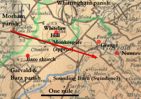
...all that land of the moor of Barewe next to the nearby
hill called Witelaw towards the west, which came to
me when the foresaid moor was divided between lady Ela
of St Martin and me, namely, by the way called Monkesgate
as far as the valley which divided that land and Witelaw,
and as the valley extends southwards as far as the Swinedene
burn, and so by that burn westwards as far as a new
ditch which Radulphus, chaplain of Barewe, then deacon
of Fife, made there as a boundary between the foresaid
land and the land now said to be the lady Ele’s;
and so northwards as far as the Monkesgate…..
....totam
terram illam de mora de Barewe proximo adiacentem colli
que dicitur Witelawe uersus occidentem, illam que accedit
michi quando predicta mora diuisa fuit inter dominam
Elam de Sancto Martino et me. scilicet per uiam que
dicitur Monkesgate usque in uallem que diuidit terram
illam et Witelawe, et sic sicut uallis se extendit uersus
austrum usque riuulum de Swinedene, et ita per riuulum
uersus occidentem usque ad nouum fossatum quod Radulphus
capellanus de Barewe, tunc decanus de Fif, fecit loco
diuise inter predictam terram et terram iam dicte domine
Ele; et ita uersus aquilonem usque Monkesgate...
=========================================
Carta Johannis prioris de May de terra de Barewe
Isle
of May Charter 34, page 25. Copy - St Andrews Priory,
page 389
For
further details see POMS
 |
| Whitelaw Hill from the west. |
This charter also from the 1200's refers to land at
Bara (see above) gifted to them by Gilbert of Bara,
called de St Martin and which the Isle of May now grants
to Ralph, chaplain of Crail. The boundaries of the land
are stated as follows:
....namely, by the way called the Monkesgate as
far as the valley which divides that land of Witelawe
and so as the valley extends southwards into the Swinedene
burn and so by the burn westwards as far as the new
ditch which Radulphus, then deacon of Fyf, made there
as a boundary between the foresaid land and the land
of the Lady Ele of St Martin, and so northwards as far
as the Monkesgate....
....scilicet per uia que dicitur Monkesgate
usque in uallem que diuidit terram illam de Witelawe
et sic sicut uallis se extendit uersus austrum in riuulum
de Swinedene et ita per riuulum uersus occidentem usque
ad nouum fossatum quod predictus Radulphus tunc decanus
de Fyf fecit loco diuise inter prefatam terram et terram
domine Ele de Sancto Martino et ita uersus aquilonem
usque Monekesgate....
Interpretation
Whitelaw Hill is clear enough and there is a strong
possibility that the Swindene Burn is now known as the
Sounding Burn. One would then follow the burn westwards
to the ditch made by Radulphus, then northwards to the
Monkesgate. This would suggest that the present day
minor road running past Chester was the Monkesgate,
although the vagueness of the charters makes this somewhat
conjectural. It is worth noting that Baro was separate
from Garvald until 1702 so there would have been a now
lost boundary separating it from the parish of Garvald,
perhaps that described in the charter.
More than this, however, is the uncertainty attaching
to the name. A road here could have reached the
supposed grange at Garvald and the associated settlement
of Nunraw, but as these are thought to have belonged
to the convent at Haddington, a Nunsgate would have
been more appropriate. There were several granges in
East Lothian (see Derek Hall, Scottish Monastic Landscapes,
p.185 ff, Tempus 2006) including some deep in the Lammermuirs
but there is insufficient information to determine if
this road was linked to any of them.
There is a possibility that this was the continuation
of an old road from Haddington to Morham Loanhead as
there is a good alignment between the two and the Morham
Loanhead road was said to have continued to Garvald
where stones were quarried for an early church in Haddington.
It would also have served the nun's grange at Nunraw
in Garvald. See here
for further information.
Another possibility is that there was this road from
Haddington to Garvald but that that it coincided in
part with another road that ran from Newbattle abbey's
granges at Monkriggs {Cresswell) and Bearford over to
their petary in Crumbrestrother. They are said in fact
to have made a "road which the same monks made
from the front of the alders (at Crumbrestrother) that
extends by the side (foot) of the hills towards the
west". This may be the true Monksgate, branching
off the Garvald road and leading to their granges of
Monkriggs and Bearford.
DUNFERMLINE ABBEY
Smeaton
Nicholaus filius Gilliberti de Smithetun
Register of Dunfermline: Charter 180, page 102.
This refers to
…that part of the lands of Smithton which is on
the east side of the great road which leads from Inveresk
in the Loning, which leads from the villa of Smithton
as far as the wood of Crebarrin and so in the western
side of the wood as far as the great road that goes
from Haddington to Newbottle, and so by that road as
far the bounds of Crebarrin……
..totam partem terre de Smithetun que
est in orientali parte magne uie que ducit de Inuiresc
in le Loning, que tendit de villa de Smithetun usque
Boschum de Crebarrin 7 ita in occidentali parte boschi
usque magnam uiam que uenit de Hadingtun usque Neubottle
7 sic per illam uiam usque diuisas de Crebarrin…

Interpretation
Smithton is now Smeaton and Crebarrin is Carberry.
The placename of the "Loaning" referred to
has not survived.
The meaning of this extract is a bit difficult to determine.
A suggested meaning is that a road led south from Inveresk
and that the land lay to the east of this in the "Loaning".
This "Loaning" (usually a strip of land for
moving cattle) would then have led from Smeaton over
to the wood of Carberry. Following the west side of
this wood led to a main road running between Haddington
and Newbattle.
If this is correct, then it is possible that the road
between Inveresk and Smeaton joined what was later known
as the "Salter's Road" at Smeaton. This ran
between Dalkeith and Prestonpans where Newbattle abbey
had salt pans and so is likely to date from the middle
ages.
The road in the charter that ran between Haddington
and Newbattle is likely to be the one shown on early
maps, e.g. Military Survey c.1750, that ran through
Penston and Elphinstone. It would have entered the area
of the charter near Crossgatehall.
YESTER WRITS
Calendar
of Writs preserved at Yester House 1166-1623, Scottish
Record Society, 1930
Dunbar
The following charters, dating from around 1600, are
for land in Beltoun, south-west of Dunbar.
Charter 976, p. 263, c.1600
".....two acres of Kirkland in the town of Beltoun
near the lands of West barnis, between the Bairdisbalk
on the west, lands of
Beltoun on the south, the water and public road on the
east, and lands of West
barnis on the north, lying in the constab. of Haddington...."
Charter 991, p. 267, 1602
"....lying between "lie bardes balk"
on the west, the lands of
Beltan on the south, the Water and Highway on the east
and the lands of
West Barnes on the north parts ....."
Charter 771, p. 214, 1573 and charter 1133, p. 312,
1612 add a couple of placenames, viz. one acre beside
the Berdisbalk between the lands of Beilhauch
on the east, Beltoun on the south and west, and three
rudis extending to one acre also beside the Berdisbalk
between the lands of Beltoun on the south and west,
the royal lands called Brwmestobbis on the east
and north.
Interpretation
 |
| General area of the charters.
Based on 1" map, sheet 33, 1905. With thanks
to Ordnance Survey. |
The general area in question is approximately 3 miles
south-west of Dunbar, where several Belton placenames
survive. There was an old village, with a chapel, both
of which have disappeared; though a likely guess is
that they were near the old tower house, now incorporated
into Belton House, or perhaps at what Roy shows as South
Belton and the modern OS map as Old Belton (Little Belton
on map at left). As the area of 2 acres was quite small,
equivalent to 100 x 100 yards, one would assume it would
have been close to the village. However, in the absence
of further information it is very difficult to give
a location for the road. It is unlikely to be the Berwick
road, which existed at the time.
Tweedsmuir
Yester Writs, Charter 157, p. 69, 1470. This was an
exchange involving land at Olivercastel "lying
between the Kingis streit and the berne burne..."
Interpretation
 |
| Olivercastle, on the Edinburgh
to Moffat road. Based on 1" map, sheet 16,
1905. With thanks to Ordnance Survey. |
Today Olivercastle is a farm very close to the village
of Tweedsmuir. This confirms that the King's Street,
undoubtedly the Edinburgh to Moffat road, existed at
that time. The Crook Inn, a mile or two to the north,
dates from 1601.
Peebles
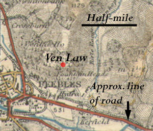 Yester Writs, Charter 241, p. 90, 1498. This charter
was for land "at the east end of the burgh of Peebles
on the North side of the King's highway between the
land of John Lawsone on W., land of John Loth on E.,
and the hill of Venlaw on N.,"
Yester Writs, Charter 241, p. 90, 1498. This charter
was for land "at the east end of the burgh of Peebles
on the North side of the King's highway between the
land of John Lawsone on W., land of John Loth on E.,
and the hill of Venlaw on N.,"
Interpretation
As the road is said to be south of Venlaw Hill,
it is likely to be the main east-west road.
Portincraig
Yester Writs, Charter 895, p. 243, 1591/2
Part of this charter reads: "....and the third
one to the said Robert Meluile, the son and his heirs
in heretage of the lands of Southferrie of Portancraig,
with the town and gate
thereof, etc., and six acres called Gibbisland with
house and tower built thereon,
towards the Craiggait to the west, the bank of Chapelbank
on the east, lands of
Jas. Hay on the south and the zairdheidis of the said
town of Southferrie on the
North,"
Interpretation
Early maps such as Ainslie (1775) and Roy (c.1750) show
just the one street. As the ferry left from the "craig"
or rock, the Craiggait probably led down to this. The
"gate" is probably the entrance to the town.
Towns
There are frequent mentions of streets in towns such
as Haddington, Dunfermline, Edinburgh etc - see Index.
Berwick-upon-Tweed
Yester Writs, Charters 9, 11 & 12, pps. 6/7, 1202-1234.
References to the hospital at the Bridge of Berewick.
Yester Writs, Charter 8, p. 5, 1202 - 1207 mentions
the road from Berewic leading to the bridge in Haddington.
Yester Writs, Charter 17, p. 12, c. 1250-1267 "I
the said Hugh Giffard and my heirs become liable to
the said Richard Soylard and his heirs for reasonable
expenses in their going from and returning to the town
of Berewich, namely for one groom and two horses if
two they have, or one horse if they have not two: And
also we are liable to
provide the said Richard and his heirs with sufficient
lodgings as we think meet for lodging them in whilst
we desire to employ them in our tradings."
Interpretation
The latter two of these charters note the existence
of the Berwick road at this early date. See here
for the course of the road in the 1600's - this is likely
to be much the same as the road in the 1200's.
Haddington
Yester Writs, Charter 26, p. 21, 1350 Mention of Giffardgatis
(village at east end of Haddington) and Haddington Bridge.
Grants towards building and upkeep of the bridge.
Yester Writs, Charter 555, p. 165, 1529 "Also
two acres of land lying at the west end of the said
burgh and within the liberty thereof, between the lands
of Thomas Dikesoun on the west, the Highway on the north,
the lands of the late Robert Dikysoun on the east, and
myldis burn on the south ; also ane acre of land lying
in Witlinstreit within the said burgh, between the lands
of the late Adam Lawsoun on the west, the Highway which
leads to the mill on the north, the lands of Laird Redpeth
on the east and the mill lade on the south, with an
acre of arable land lying in the Mylltlat within the
liberty of the said burgh, between the lands of Andrew
Mayne on the west, the Myldis burn on the north, the
lands of "lie Walkmyl" on the east, and the
High way which leads to Clerkintoun on the south."
Interpretation
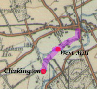 The course of the Clerkington road has been lost. The
Reminiscences of the Royal Burgh of Haddington etc.
by John Martine (page
16) says there was an old cart road from the High
Street to the West Mill but that no trace of it remains.
Alternatively it could have gone by the Mill Wynd, again
leading to the mill. From there, Roy (c. 1750) shows
a road crossing a ford and running opposite to Clerkington
where it crossed the river again.
The course of the Clerkington road has been lost. The
Reminiscences of the Royal Burgh of Haddington etc.
by John Martine (page
16) says there was an old cart road from the High
Street to the West Mill but that no trace of it remains.
Alternatively it could have gone by the Mill Wynd, again
leading to the mill. From there, Roy (c. 1750) shows
a road crossing a ford and running opposite to Clerkington
where it crossed the river again.
Witlinstreit (presumably Watling Street) is interesting
but may just reflect the vague antiquarian tradition
of a Roman road passing through the area.
Middleton
 |
| The area around Middleton. Based
on OS 1" map, sheet 74, 1928. With thanks to
Ordnance Survey. |
Yester Writs, Charter 23, p. 18, c.1330 This was a
charter by William de Vaux confirming a grant of land
to Donald Fitz Duncan, namely: "two oxgangs of
land (approx.30/40 acres, equivalent to about 400 yards
by 400 yards in the territory of Middleton. which lie
between the land of Patrick de Haya next the Road which
leads to Thirneopesheud and abutts on Gwynesheleford
towards the East, abutting on the land of the said Patrick
towards the South, and stretching in length by the said
road which is next Thirneopesheued to a land called
the Wetrik, descending on that boundary to Suthburne
on the East side of the Merestal; With a toft and croft,
which lie near the said two oxgangs, bounded as measured
and perambulated bv me and the good men of Middleton
and elsewhere ..."
Interpretation
None of the placenames survive, except possibly
Suthburne, if this is the present day Middleton South
Burn, which would place the road south of this.
Granges
- Nunhope and Newlands
 |
| Two of the granges
belonging to Haddington convent. There was a connecting
road between them, and each was connected to the
convent in Haddington which lay about one mile east
of the town at Abbey. Routes shown are approximate.
Based on half-inch map, sheet 28, 1914. With thanks
to Ordnance Survey |
The following two charters refer to routes taken from
the granges at Nunhope and Newlands to Haddington, and
also between the two granges.
Yester Writs, Charter 20, p.15, 1327 In this charter
John Gifford, Lord of Yester, acknowledges a dispute
with the convent of Haddington over access to their
granges at Nunhope and Nunland, and other places but
"confirms to the said Nuns and their successors
free and common transit beyond the corn and meadows
enclosed in fence at all times of the year in all roads
and paths of use at any time from the Nunhope to the
town of Yestre and thence to their House of Hadygton,
and from the said Grange of the Nunhope to their foresaid
Grange of Nunland, and from that grange and all other
granges, lands, woods, petaries, and turbaries in all
roads and paths commonly used to their said House of
Hadygtoun with wains, carts, horses, and any kind of
animal whenever they require forever without contradiction
or hindrance from me or my heirs or anyone in our name..."
Interpretation
This is a clear indication that the Nunhope road went
through Yester and then onwards to Haddington. There
was also a connecting road with the grange at Newlands
and a route from Newlands to Haddington. With their
several properties in the area such as Snawdon, rights
to part of Crumberstrother, Carfrae and Newtoun it is
likely, as the charter implies, that there were other
tracks available to the nuns to reach such places.
---------------------------------------------------------------------
Yester Writs, Charter 500, p. 151, 1533.
 |
| Nunhope lies just ahead in
this narrow valley. |
The same rights of passage over the same roads from
Nunhope and Newlands are granted by John Gifferd Lord
of Zester and Baron of the Baronies of Morhame and Dunkanelaw
in this document, viz: "granting to the said prioress
and
convent and their successors free and common passage
by cornys and medowis putt in defence all tymes of the
zeir in all wayis roddis any tyme usit frae Nunhope
to the toun of Zester and fra thyne to thaire place
of Hadingtoun and fra thair Grange of Nunhope to thair
Grange of Newlandis and fra the said Grange and all
utheris thair Grangis and landis wodis petis and turifis
in all gatis and roddis commonlie usit to thair said
place of Hadingtoun with wanys cartis hors and all utheris
bestis als oft as neid beis. "
-----------------------------------------------------------------------------
Yester Writs, Charter 418, p. 130, 1525. "Interrogators
to be demanded at the witnesses to be produced for the
prioress and convent of the Abbey of Haddingtoun anent
the action moved by them against John Lord Hay of Zestir,
for the alleged stopping of carts from passing through
the common gates."
Nunhope
and Crumberstrother
 |
| Map showing part of the boundary
between the nun's lands and those of Yester. Based
on half-inch map, sheet 28, 1914. With thanks to
Ordnance Survey |
Yester Writs, Charter 417, p. 130, dated 1525, and
the similar charter 426, p. 132, dated 1526, detail
the marches between the "lands of Newlandis, Carfra
and Nunhopis alias Zestirhopis with their pertinents,
pertaining to Elizabeth on the one part, and the lands
of Duncanlaw, Zestir and Park of Zestir,with their pertinents
pertaining to John Lord Hay of Zestir on the other part".
These boundaries have been identified in a study by
Robert Waterston in the Transactions of the East Lothian
Antiquarian and Field Naturalists’ Society (vol.
5, 1952), viz. An XVIth Century Boundary Perambulation,
Pages 25 - 38.
They start at Knock Hill (Heslised Knock) and run down
to the Hope Water (Yester Burn) and follow this as far
as Brookside Burn (Doddis Burn). This is then followed
upstream (south of Dodd Law) to some flat ground at
the head of the burn, then south-east through a gap
to a standing stone called the Pykit stane which he
identifies as the Whitestone Cairn (on Harestane Hill).
The boundary then crosses to the eastern headwaters
of the Faseny Burn (Innerkemp) which it follows downstream.
Of interest to us, is the mention in the second charter
of a "roid", viz. where the boundary runs
from "the southt pykit stane eist to the roid
that cumis wpe fra the eister heid graine (branch of
a stream) of Innerkempe safer upe as the southt twa
stanis liis erdfast..... The equivalent in the first
charter is " ....to the standand stane utherwayis
callit pykyt stane quhilk is the heid of Innerkent and
fra thine downe to the heid of Innerkent burne passand
downe as the said (burne) rynnis...."
While sections of the charter are obscure and placenames
have changed or disappeared, it seems clear enough that
this "roid" was a track running between the
Faseny Water and the high ground near to Harestone Hill.
 |
| Crumberstrother |
The same two charters mention a location called Crumberstrother.
Waterston does not identify this but a
contributor (WP) to the Scottish Placename Society "Placename
notes from the Newsletters" (Autumn 2004) on Crumbystruder
Myr makes a convincing case for this being a distinctive
landscape feature just north of Danskine Loch. The charters
deal with the boundaries of the myre, the sharing of
its resources and access rights.
Of particular note is the mention in charter 427, p.
132, (1526) of a wooden bridge across the marsh, viz.
"fra the saidis merche dyke (of the nuns' lands
of Carfrae) and stanis to the flaik brig." This
is also mentioned in charter 841, page 230, 1583 as
" lie " Flakersydbrig. The DSL gives the meaning of
flaik as a "hurdle or framework of crossed slats,
gen. portable and used as a fence, barricade, gate."
In this case it would be a walkway.
Road
between Bothans, Duncanlaw and Newlands Grange
 |
| Possible lines of road. Based
on half-inch map, sheet 28, 1914. With thanks to
Ordnance Survey. |
Yester Writs, Charter 154, p.69, 1470 which deals with
arrangements for a mill on the Water of Yester mentions
"the gate that gais fra the Bothanis to Duncanlaw."
Another charter (Yester Writs, charter 16, p. 10, 1250-1267
) may refer to the same road between the Bothanis and
Duncanlaw, viz. "namely from the ford of the burn
called Yester as the Kilnunrodes descend by that ford
towards Duncanlaw and thus ascending northwards by the
right side of the Kilnunrodes until opposite Berndene
and thus going or crossing by Berndene and ascending
through Berndene to the very top of the cultivated land
of the Chapel of Duncanlaw and then between the said
cultivated land and the wood to Welldene and thus crossing
Welldene for a space descending and (crossing?) through
the left side until it comes to the bottom of Welldene...."
Interpretation
Forrest's
map of 1799 shows Duncanlaw to be about one kilometre
east of its present position, at Cross Hill.
As Welldene's position is known, one would expect Berndene
to be the stream running past Sunnyside. If we assume
that the starting point of Bothanis was close to the
old church (Gifford dates from the 1700's so the old
village must be meant) then descending to the Water
of Yester fits the second charter. One would then climb
uphill past Sunnyside towards Duncanlaw to reach Berndene.
From here to Welldene is about a kilometre.
It is not quite clear what route the Kilnunrodes took
after crossing the Water of Yester (Gifford Water) but
there has to be a strong presumption that it led ultimately
to the grange at Newlands. The nuns also had lands at
Carfrae and Snawdon which could account for the use
of the plural "rodes" - they would be within
easy reach of the Duncanlaw area. The grange at Newlands
was said to have had a road leading to Haddington which
could be the Kilnunrodes routed through Bothanis then
north through Gifford although a more direct route could
have been from Duncanlaw past Winding Law.
The Yellowpeth
and Other Tracks
This is mentioned in the continuation of the above charter
(Yester Writs, charter 16, p. 10, 1250- 1267) after
the bottom of Welldene, viz. "and then mounting
to the very top of Maistercroftes between the cultivated
land of Maistercroftes and the wood as far as the eastern
summit and then ascending northwards beyond the wood
to the cultivated land and then between the cultivated
land and the wood to the ford of the burn of Yellowpath
which is between my land and that of the Nuns of Haddington..."
The Yellowpath (Zallowpete/Zallowpeth) is also mentioned
in two other charters (Yester Writs, charter 1051, p.
286, 1607 and charter 841, p.230, 1583) both of which
deal with the same boundaries although the placenames
have changed a little. These charters also mention several
route-related placenames, viz. Craigfurde (Craigfurde),
Fleschfurde (Pleschefurde), Bowbriggis of Bothanis (bowbrig
of Bothanis), Sandifurde (Sandifurde), Barro Kirkstyle
(Barro Kirkstyle. There is a Lidgait (Litgaitt) but
this is more likely to be a latched gate than a road
(see DSL), though it would be on a track. The Flakersydbrig
which we have already noted above under Nunhope and
Crumberstrother (flaik brig) appears again.
 |
| Some of the charters mention
various tracks, fords and a couple of bridges including
a flaik bridge which led across marshy ground. Based
on half-inch map, sheet 28, 1914. With thanks to
Ordnance Survey |
Interpretation
These charters afford some clues as to the location
of the various tracks and fords, as follows:
• Yellowpeth This is
mentioned after Crumberstrother and the Flakersydbrig
and before Weldencleuch
• Craigfurde This is
somewhere between Weldencleugh and Suonedonmyre (Snawdon)
• Fleschfurde This is
mentioned near to Welburne so may have been over that
stream
• The Bowbriggis of Bothanis
This suggests a bridge over the Water of Yester
near to the village at the old church and would
give access to Duncanlaw by "the gate that gais
fra the Bothanis to Duncanlaw."
• Sandifurde A Sandyford
is marked on early maps just north of Gifford and some
land called The Common. It could entail a route
to Haddington.
• Barro Kirkstyle This
refers to the old church of Baro where the style would
have been over a wall or fence on a track leading to
the church.
Possible locations of these places are shown on the
map.
Public Road;
Road between Bara and Newtoun
 |
| Some of the places mentioned
in the text. Based on half-inch map, sheet 28, 1914.
With thanks to Ordnance Survey. |
Yester Writs, Charter 841 starts the boundary
at the "temple lands of Barro lying
on the south part of Barro, between the lands of Mayland
on the east and Brounhill on the west, the public road
on the north, and the stream between Barro and Newtoun
on the south." Another charter (charter
1012, p. 274, 1604) is almost identical but instead
of "the stream between Barra and Newtoun on the
south" has "the road leading between Barro
and Newtoun on the south..." Brounhill may be present
day Brownhill but Mayland is lost making it difficult
to place the first road, perhaps the road between Garvald
and Haddington (see Nunraw). Newtoun was just east of
Bara Loch and just south of the Sounding Burn though
the two descriptions are confusing. This location would
fit the first description although the wording "the
road leading between Barro and Newtoun" is a more
definite reference to a road. It was likely a local
track to serve the convenience of Newtoun.
Fawsyd Gait; Cachtlamis Brighe
Yester Writs, Charter 24, p. 19, c. 1340. This
was a confirmation by Eufemia Giffard, widow of Sir
John Giffard of a grant of a half carucate of land (30-40
acres, or approx. equivalent to 400x400 yards) in the
tenement of Barow by its right bounds, namely, "descending
from the hospital to Vydenmyr, thence ascending to the
common exit which leads to the west side of Barw, thence
to Harlawmore, thence from the west side of the said
exit to the ford which leads from Harlawmore to the
road called Fawsyd gait, thence ascending to the site
of the bridge called Cachtlamis Brighe, and thence from
that road to the land which once belonged to Alexander
de Stratum." Free entry and exit and common pasture
were also granted.
Interpretation
The hospital was sited just south west of Linkylea
House and Vydenmyr was probably some marshy ground near
the Sandyford Burn (cf. Myreside and Winding Law). Charter
1051, p. 286, 1607 indicates this is the correct area,
viz, "Sandifurde and eastward to the common meadow
"prerious land" to Wyndenmyre and ascending Wyndencleuch
to the Crofts of Duncanlaw, and from the common meadow
eastward to the Skramure and Barro Kirkstyle" but
does not help identify the features.
Yester
 |
| One of the roads mentioned may
have ran between Yester and Duncanlaw. The other
may have entered the village from the south (perhaps
from Nunhope) and continued northwards. Based on
half-inch map, sheet 28, 1914. With thanks to Ordnance
Survey |
Yester Writs, Charter 79, p. 52, 1442/3. This
charter by David Hay granted a portion of land "lying
on the south part of the said church (Collegiate church
of Bothanis) between the land of Dame Alice of Hay,
Lady of Yester, on the east part, and the common way
on the west part and the path lying between the ditch
of the burying ground and the said piece of land on
the north part of the computed space of 6 feet from
the said land along to the said ditch and common way
on the south, with the croft of the said piece of land
lying on the south part thereof, commonly called le
Orcharde croft, and so extending towards the east along
to a cross of stone on the south part of the said Orcharde
Croft, and so descending by the path which runs along
to the south entry of the said burying ground, with
the grazing of one horse and 2 cows with their followers..."
Interpretation
The ruins of the Collegiate Church (formerly St
Cuthbert's) lie close to Yester House and were used
as a burial vault by the family. From the charter there
seem to have been common ways on the west and south
of the cemetery. The one on the south could conceivably
have run up to Duncanlaw - i.e. be "the gate that
gais fra the Bothanis to Duncanlaw."
-----------------------------------------------------------
Yester Writs, Charter 176, p.74, 1474. This was
a charter of David Hay, Lord of Yester granting Alexander
Lempetlaw in the town and territory of Bothanis, on
the west of the marches of the lands of Gamilstoun,
on the one part, and on the north the common way on
the other part, and on the south part a croft of the
rector of Morham, which pertained to the Collegiate
Church of Bothanis, commonly called "le Staw"
of the said rector....
Yester Writs, Charter 404, p. 127, 1523. This
dealt with land in the same locality, viz. a tenement
of land with yard and pertinents lying in the town of
Bothanis between the land of the late Alexander Lempetlaw
on the south, the land of the chaplain of St. Edmund
on the west, the King's way on the east and north....
Yester Writs, Charter 555, p. 165, 1529 This
charter also refers to the common street on the east
and the north, viz. the tenement of land lying in the
said village of Bothanis on the south part between the
land of the Holy Cross on the west, the common street
on the east and north and the croft of the rector of
Morhame on the south
Interpretation
The road mentioned is the common way/King's way
on the east and the north situated between Gamilston
and the village of Bothanis. However, additional information
would be needed to fix the precise position of the road
though there is a sense that it ran past the village
on its eastern side and then proceeded northwards.
Haddington
to Garvald
 |
| There was an old right-of-way
from Haddington to Morham Loanhead, said to have
originated as a route along which stones were brought
from quarries at Garvald for the building of one
of the churches in the town. Between Morham Loanhead
and Garvald, old charters refer to a road called
the Monkesgate which is probably the same road though
there may have been a branch over to the petary
at Crumbrestrother. Based on 1" map, sheet
33, 1905. With thanks to Ordnance Survey. |
In Reminiscences
of the Royal Burgh of Haddington (pps.87 & 294)
Martine says there was an old cart and foot road called
Stabstane Loan that ran from Winton Barns, near Haddington,
ran through Bearford Farm and the muir to Morham Loanhead.
It is presumed to have continued to Garvald though by
what line is not known. It was closed up a long time
ago and was often impassable in bad weather. Tradition
says that stone from quarries at Garvald were taken
to Haddington for use in building the Collegiate church,
work on which started in 1380.
Also in Reminiscences (p.87) Martine says that the road
ran from the convent's church of St Martins to the nunnery
at Garvald, presumably one of the granges.
While the Armstrong's
(1775) and Forrest
(1799) show this road including the present day
roads between Morham Loanhead and Garvald, Roy
(c.1750) does not show this latter section. Roy
however does not always show all roads so we cannot
say from this that the road did not exist around 1750.
There is in any case a clue to the section between Morham
Loanhead and Garvald in a couple of charters for Garvald
and Bara parish (link)
dating from the early 1200's that refer to a road called
the Monkesgate. This was between the moor of Bara and
Whitelaw and was in the same general location as the
presumed Garvald road.
While the name Monkesgate is puzzling one solution
is that it relates to Newbattle abbey who had granges
at Monkriggs (Cresswell) and Bearford just south and
east of Haddington and a petary at Crumbestrother. On
this reading the road would have run from the granges
to the petary and in fact one charter talks about the
"road which the same monks made from the front
of the alders (at Crumbrestrother) that extends by the
side (foot) of the hills towards the west". This
need not interfere with the tradition of the road from
Haddington to Garvald as part of the Monkesgate could
have been used as this with a direct link to Crumbrestrother.
NEWBATTLE ABBEY
Register
of Newbattle Abbey
Additional
details of Newbattle charters can be found on the POMS
site here.
People
of Medieval Scotland. Amanda Beam, John
Bradley, Dauvit Broun, John Reuben Davies, Matthew Hammond,
Michele Pasin (with others), The People of Medieval Scotland,
1093�1314 (Glasgow and London, 2012) www.poms.ac.uk.
KRESSEWELLE
Carta Hugonis Gyftard •
Charter 81, Page 63
 |
| Area around Cresswell (Monkrigg)
aand Bearford. Based on half-inch OS map, sheet
28, 1914. With thanks. |
This is a charter of Hugh Gifford donating the lands
of kressewelle to Newbattle. The boundaries were: ...namely,
from the road which leads from leuendington as far as
Bereford as far as the bounds of Morham and Combrecolyston..
scilicit a via que
ducit de leuendington usque bereford vfque ad diuisam
de Morham et Combrecolyston
Interpretation
POMS
identifes this with Monkrigg, south of Haddington, which
accords with the description as Leuendington (Levington)
was in the area south of Waterloo Bridge, and Colstoun
just south of this. The road appears to join that coming
past Bearford to Haddington - see Haddington to Garvald
Road.
Carta Johannis Gyffard
Charter 83, Page 64
This charter was by Hugh Gifford's grandson confirming
the donation of Kressewelle, as follows:
....... from the road which leads from leuidinton as far
as Bereford as far as the bounds of Morham and Combrecolyston
and by the ditch set between kressewell and the lands
of Leuediton ...
scilicit a via que ducit de Leuidinton
usque bereford usque ad divisam de Morham et de
Combrecolyston • et per fossam que dividit inter
kressewelle et terra de Leuediton
Interpretation
See above
BEREFORD (See above map)
Charters 87 & 88, Page 66
These charters of of John and Thomas of Morham refer
to a mill pond at Bereford and to the firm land of Morham
and the ford of Bereford, viz:
...his millpond on my land of Bereford with divisons
as the stream now flows and the whole of the marsh from
the western side of that grange as far as the dry lands
of Morham and as far as the ford of Bereford…
...stagni molendini sui de Bereford super terram meam
et diuisas sicut riuulus nunc fluit et totu maresium
ab occidentali parte ipsius grangie vsque ad firmam
terram de Morham • et vsque ad vadum de Bereford
Another charter by John Malherbe of Morham (Charter
103) relates to Crumbrestrother, a mill pond
at Bereford on his lands of Morham and mentions the
ford of Bereford.
Interpretation
The 6" map (Haddingtonshire,
sheet 10, series 1) shows a couple of fords over
the Bearford Burn, just south west of Bearford, and
on the road called the Stabstone Loan. This originated
as a route along which stones were brought from quarries
at Garvald for the building of a church in the town,
and which may have been known as the Monkesgate. It
may also have been used by Newbattle to reach their
petary at Crumbestrother from their grange at Bearford.
CRUMBRESTROTHER
 |
| Crumbrestrother. Other than
that the roads mentioned in the charters were probably
to the north and west of the marshy ground, little
can be said of them. Based on 1" map, sheet
74, 1928. With thanks. |
Carta Alexander de Sancto Martin
Charter 102, Page 76
This charter of Alexander of St Martin gave Newbattle
"that part of my petary in Crumbestrother, to hold
to them from the front of the alders as much of my petary
extends towards the southern part
[illam partem] de petera mea in Crumbrestrother
� tenedam illis ab alnata fronte � quantum petera mea
se extendit versus australem partem �
Carta Ele de sancto Martino Charter 102, Page 76
This was a confirmation by Ele of St Martin, his daughter,
in which the bounds are detailed, viz.
from the front of the aldergrove as much as it extends
towards the south of the same petary, and by that road
which the same monks made from the front of the alders
that extends by the side (foot) of the hills towards
the west…
She also allowed free entry and exit through her land
for the carrying of their fuel. There is a possibility
that the road referred to was the Monkesgate coming
from the granges at Cresswell and Bearford.
videlicit ab alnata fronte quantum
ipsa petera se extendit versus australem partem •
et per illam viam quam ipsi monachi fecerunt ab alnata
fronte que se extendit per costeram montis versus occidentem
•
Confirmacio Regis Alexander •
Charter 104, Page 77
Alexander's charter was also confirmed by King Alexander,
viz.
.....his petary of Cumbirstrother from the front of
the alders as far as the petary extends southwards.
I concede also and by this my charter confirm and concede
that Ela daughter of the same Alexander made to the
same monks free entry and exit to their firewood and
carrying this by their lands…
de petera sua in Cumbirstrother ab
alnata fronte quantum petera se extendit versus australem
partem • Concedo etiam • et hac mea carta
confirmo concessione illa quam Ela filia eiusdem Alex
fecit eisdem monachorum de libero ingressu et egressu
ad focalia sua cariada per terram suam •
Carta Johannis Malherb
Charter 105 Page 78
Crumberstrother is also mentioned in a charter of John
Malherb, lord of Morham, which granted Newbattle:
…a certain piece of my land of Duncanlaw next to
his (my) petary of Cumberstrother for drying their fuel,
by these divisions, namely as a certain old road which
is in the northern part of the nearby front of the alders
by the side of said petary of the monks as far as a
certain well/spring as stones in the western side of
this land have been placed as a division.
I also give to them and concede a certain part of my
petary of Cumbirstrother next to the foresaid petary
of the said monks from its northern side, as a certain
fosse made as a boundary extends from the previously
mentioned old road which is on the north side of the
front of the alders as far as a certain large stone,
which lies above the nun’s lands of Haddington
towards the east.
I also concede and confirm to them those two roads which
are often said to be near the frontage of the alders
on both sides*, and free entry and exit throughout all
my lands without obstruction etc.
[* This translation is approximate but the sense seems
to be that there were two roads giving access at the
front of the petary]
……quendam particulam terre mee de duncanlau
iuxta peteram suam de Cumbirstrother ad focalia sua
siccanda per has notiatas divisas scilicet a quendam
via vetusta que est in aquilonali parte alnate frontis
proximi ipsi alnate fronti per costeram predicte petere
monachorum usque ad fontem quendam sic lapides in occidentali
parte huius terre (of this land) posite per divisis
testant.
Do et eis et concedo • quendam particulam petere
mee de Cumbirstrother • proximam predicte petere
predictorum monachorum ex aquilonali parte • sic
fossa quendam facta per diuisis extendit se a vetusta
via predicta que est in aquilonali parte alnate frontis
vsque ad quendam magnum lapidem • qui iacet super
terra monialium de Hadington (i.e. nuns) versus orientem.
Concedo et eis et confirmo illas duas vias que sunt
sepedictere (often said to be?) alnate fronti Proxime
ex uterque parte et liberum ingressum et eggressum per
totam terram meam sine omni impedimento et vexacioe
ad focalia sua carianda et ad dictam petera sua vtendam
Interpretation
Intriguing though these descriptions of various
paths are, they are very difficult to interpret. Other
than that they relate to the north and west sides of
Crumberstrother, little can be said of them.
WESTFORTON (Athelstaneford
parish)
Carta Nesi • filii Johannis de lundres •
Charter 107, Page 80
This was a grant of land in Westforton by Ness, son
of John of Lundres. The charter dates from the early
1200's. The grant was for:
A half carucate (30 plus acres) of land in my feu of
Forton, by these noted and patent divisions, namely,
from Herteburne towards the east by erected stones as
far as the stone cross, and from thence descending towards
the north by a sike and stones as far as the via regia,
and from there towards fortun as far as stones erected
by the same road, and from thence towards Pefer by erected
stones….
....vna dimidiam carucata terre in
feudo meo de Forton • per has notiatas et patentes
diuisas scilicit
de Herteburne yersus orientem per lapides erectos usque
ad Crucem lapideam • et inde descendendo versus
aquilonem per sicum et lapides usque ad viam Regiam
• et inde versus fortun usque ad lapidem iuxta
eandem via erectum • et inde per lapides erectos
usque in Pefer....
Interpretation
See below
DREM
Carta Johannis filii Johannis de Lundres •
Charter 114, Page 84
 |
| Based on half-inch OS map, sheet
28, 1914. With thanks. |
This was a gift to Newbattle Abbey of 5 acres of land
by John, son of John of Lundris, which his brother:
....lord Nesius de Lundris gave to me in the parish
of Lyntone, in pure and perpetual alms, [and] noted
by these divisions, namely as Hertteburne falls from
the road which leads from Drem and leads below north
towards the east (north-eastwards?) and flows from the
western side of the same land as far as the lands of
the same monks of Pouerhou which they held from the
gift of my brother Sir Nesii, and thence from the north
side of the same land as three stones are placed, as
far as the east, and as from that stone placed in the
east in the direction as far as that stone placed alongside
the noted high road
Quinque acras terre de terra mea • quam frater
meus dominus Nesius de Lundris michi dedit in parochia
de Lyntone • in puram et perpetuam elemosiniam
• notiatim per has divisas scilicet sed Hertteburne
cadit a via que vergit de Drem • et tendit subtus
aquilonem versus orientem et defluit ex occidentali
parte ipius terre usque ad terram ipsorum monachorum
de Pouerhou quam tenent de donacione domini Nesii fratris
mei • et de hinc ex aquilonari parte ipius terre
sicut tres petre posite sunt • usque in orientem
• et sicut de illa petre in oriente posita in directum
vsque ad illam petram positam secus viam superius notiatam.....
Interpretation
Although a couple of the placenames in these charters
such as West Fortune, Drem and the Pefer Burn have survived
they are not enough to identify the lands described
in the charters. There is a sense that they are dealing
with land north of West Forton up to the Peffer Burn
which suggests the road was one running east from Drem.
EDINGTON
Carta Johannis de Edynton
Charter 205 Page 164

This was a grant by John of Edington granting Newbattle
the right to travel through his land of Edington on their
way to and from Berwick, and to overnight there with their
carriages and animals. Dated 1290's
Interpretation
Edington was 2 miles east of Chirnside and 12 miles
distant from Berwick. Without further information it
is difficult to say what route would have been followed
but an easy route would have been through Ellem and
Cranshaws to the granges near Haddington.
Top |