|
Swinton
In 1251, the bishop of St Andrews gave Kelso permission
(among other things) to use revenues from the church
of Symprinc to help the poor and to show strangers hospitality.
Monastic
Annals of Teviotdale, page
127; L. de Calchou charter
277, page 228
Identification
Symprinc church (now Simprim in Swinton parish) was
situated about 4 miles north of Coldstream. It is not
clear from the charter what route/s might have been
used by those receiving hospitality although Coldstream,
Berwick and Kelso must be possible destinations.
Fogo
Bothkil
This item has been
moved to East Lothian under Lammermuirs, Spott
parish..
Grenrig
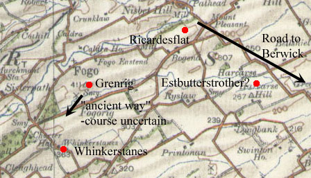 A
later charter (early 1200's) mentions two other roads
in Fogo, viz. "Leading southwards to Grenrig, then
by a certain ancient way to my meadow which lies between
Grenrig and Aldefoghou, and then westwards from that
meadow to the stones set as a boundary between the land
of the monks and that of the men of the village and
then from the stones to a certain stream that descends
from Blyndewell." A
later charter (early 1200's) mentions two other roads
in Fogo, viz. "Leading southwards to Grenrig, then
by a certain ancient way to my meadow which lies between
Grenrig and Aldefoghou, and then westwards from that
meadow to the stones set as a boundary between the land
of the monks and that of the men of the village and
then from the stones to a certain stream that descends
from Blyndewell."
"tendente
versus austrum usque ad Grenrig, et ex traverso Grenrig
per quandam antiquam semitam usque ad pratam
meum quae jacet inter Grenrig et Aldefoghou et ab illo
prato in occidentem usque ad lapides positos pro divisa
inter terram eorundem monachorum et terram hominum villae,
et de lapidibus usque ad quendam rivulum descendentem
de Blyndewelle."
Monastic
Annals of Teviotdale,
page 128, L. de Calchou charter
303, page 244
Identification
Unfortunately early maps are of no help in identifying
Aldefoghou and Blynedwelle. There is a Green Rig just
south of Fogo village and, more speculatively, Whinkerstones
one mile SSE of Green Rig. At best, this suggests the
"ancient way" was near Green Rigs and ran
west or south-west from there.
Ricardflat
The other mention is
later in the same charter, "Furthermore I give
to these monks four acres of land next to their territory,
lying to the east, on both sides of the road which leads
to Berewic, which land is called Ricardflat, next to
the Blakeder."
"Praeterea
dedi eisdem monachis quatuor acras terrae contiguas
terrae eorundem monachorum, ex orientali parte jacentes,
ex utraque parte viae quae tendit versus Berewic,
quae vocantur Ricardflat, juxta Blakeder."
Monastic
Annals of Teviotdale, page
128, L. de Calchou charter 303, page 244
Identification
The complete charter suggest this was in the eastern
part of Fogo parish as it has a boundary running north
to the Blackadder then heading east down river to Ricardesflat
from where it turned southwards to run to an Estbutterstrother
then up by a stream to a Westbutterstrother and heading
westward to complete the circuit. This would then place
Ricardesflat beside the Blackadder at the east end of
the parish.
It is tempting to think that it in fact defines the
eastern boundary of Fogo parish as Pont has a Bitrigsyde
(Blackadder's
map shows it as Bitterigside) just north of Harcarse
Hill and beside a stream that leads westwards (strother
indicates a marshy place - see Dictionary
of the Scots Language).
From this, one could suggest that
the road to Berwick ran from Ricardesflat, i.e. at the
east end of Fogo parish beside the Blackadder, effectively
where the Swinton to Duns road (A6112) runs. Interestingly
enough the parish boundary follows this road for some
two miles southwards to Harcarse which could suggest
this was the said road to Berwick although a more direct
route could have been possible if the ground was not
too marshy.
Langton
The Monastic Annals
refers to a charter in the time of King William (reigned
1165-1214) that confirmed a grant of the church of Langton
and some land to Kelso Abbey. The boundary ran "along
the road on the east side of the church to Wedderburn,
and thence to Humpulles and Langlands." To make
a full ploughgate the donor added "the land called
Gretryg, bounded by ditches from Holeburn to Stocfutcluh,
and from thence to Fulstrother by the syke, and eastwards
to the arable land and meadow of Fulstrother, and thence
to the syke which runs between Gretryg and Stamkilchestre,
and down the syke to the path which goes to Holeburn,
on the west of Chimbelawe, and up Holeburn to the above
named ditches."
Monastic
Annals of Teviotdale, page
130, L. de Calchou charter
140, page 108
Identification
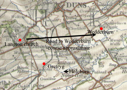 The
only Wedderburn that appears on early maps lies approximately
2 miles due east of the site of Langton church. If this
is the Wedderburn in question there are no indications
of its route though a fairly direct route is likely.
There is no trace of Humpullas or Langlands. The
only Wedderburn that appears on early maps lies approximately
2 miles due east of the site of Langton church. If this
is the Wedderburn in question there are no indications
of its route though a fairly direct route is likely.
There is no trace of Humpullas or Langlands.
The early maps show a Gritrig (NT 774 509) one mile
south of Gavinton, very near to the Howe Burn - this
is presumably the Holeburn of the charter. The text
is too vague, however, to fix the path with any certainty.
Ulfkilston,
or Oxton (in Channelkirk parish)
 A
charter of Kelso Abbey dating from the time of Malcolm
IV (reigned 1153-1165) refers to a grant of land in
Oxton. The charter reads: "'From the head of Holdene
descending by the Holdene burn to Derestrete and then
by Derestrete heading north to Fuleford and, by Samson's
divisions, to the Leader, and so by the Leader ascending
in a straight path to the east end of the said town
of Hulfkeliston, and from the east end of Ulfkiliston
taking a straight path by the south street* and ascending
to Derestrete, with the exception of the tofts and crofts
of William de Colilaw and Richard son of Gaufredi, and
so by the same road southwards to the cross, thence
westwards as crosses have been placed and ditches made
as far as the road coming from Holdene and so by the
same road as far as the head of Holdene." A
charter of Kelso Abbey dating from the time of Malcolm
IV (reigned 1153-1165) refers to a grant of land in
Oxton. The charter reads: "'From the head of Holdene
descending by the Holdene burn to Derestrete and then
by Derestrete heading north to Fuleford and, by Samson's
divisions, to the Leader, and so by the Leader ascending
in a straight path to the east end of the said town
of Hulfkeliston, and from the east end of Ulfkiliston
taking a straight path by the south street* and ascending
to Derestrete, with the exception of the tofts and crofts
of William de Colilaw and Richard son of Gaufredi, and
so by the same road southwards to the cross, thence
westwards as crosses have been placed and ditches made
as far as the road coming from Holdene and so by the
same road as far as the head of Holdene."
Videlicet
a capite del Holdene descendendo per rivulum de Holdene
usque in Derestrete et sic per Derestrete
versus boream usque fuleforde per divisas Samsonis usque
in ledre et sic per ledre recto tramite ascendendo
usque ad capud orientale eisdem ville de Hulfkeliston
et a capite orientali de Ulfkiliston recto tramite
per vicum australem ascendendo usque ad Derestrete
exceptis toftis et croftis
Willius de Colilawe et Ricardi filius Gaufredi et sic
per eandem viam versus austrum usque ad crucem
et inde versus occidentem sicut cruces posite sunt et
fosse factum sunt usque ad viam venientem de
Holdene et sic per eandem viam usque ad capud de Holdene.
*vicus refers to a street rather than
a road, presumably it was through the village
Monastic Annals of Teviotdale, page
131; L. de Calchou charter
245, page 202; R H Hardie, Roads of Mediaeval Lauderdale,
page 88; Allan Archibald, History
of Channelkirk, Edinburgh, 1900, page 664
Identification
Following Hardie (Roads of Mediaeval Lauderdale
- p.88) and Archibald (History of Channelkirk - p.664)
it is clear that the Holdene is the Howden Burn near
Overhowden (NT49 52) along which the boundary ran to
reach Dere Street and then turn north. Dere Street here
has the line of the minor road running from Midburn
into Oxton. It is not clear if the Fuleford was over
one of the burns just north of here (see Armstrong's
map) or if it was nearer to Carfraemill. In any
case it followed the Leader up to Oxton where the old
6"map (sheet XIII) clearly shows a road running
from Nether Howden west into Oxton. It is not clear
if the tramite of the charter denotes a footpath
beside the Leader or just has the meaning of going
directly although no doubt there was a footpath
along the river.
From Nether Howden it ran a short
distance west to Oxton to reach the village and Dere
Street (which runs through Oxton) then turning south
along Dere Street to the village cross. From there it
turned west to reach a road leading up to Overhowden.
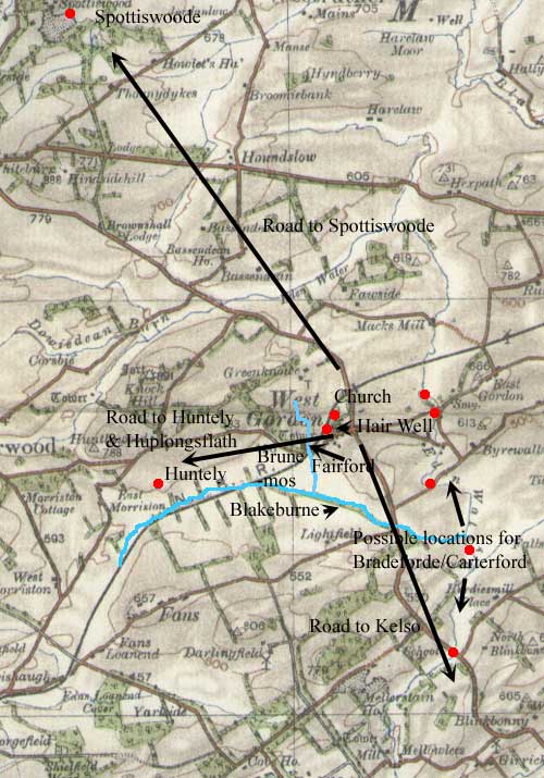
Gordon
Several charters
in the Chartulary of Kelso Abbey refer to roads in this
parish. Although they look very promising with their
mentions of roads and fords, they prove difficult to
interpret as most of the placenames are lost. The most
definite conclusions that can be drawn are that there
was a road between Gordon and Spottiswoode, at that
time a part of Gordon; and a road to a place called
Huntely and beyond as well as a road to Kelso. Also
fairly definite is the placing of Fairford on the Huntely
road.
Less definite are the locations
of Bradefurde, Carterford and Cothlandisforde as well
as the Cartergate.
 Charter
1 Charter
1
One was a grant in the late 1100's by Richard of Gordon
of the church at Gordon and some land associated with
it. Its boundaries were as follows: "all that land
from the cemetery as far as the consecrated Lippestan*,
and from there to the priest's curia (?court/assembly
place), and towards a certain ditch by the croft
of Roberti Rikeloc, then to Gateyeth, and towards the
road that goes to Gordon, and by that road up to Damdhic,
and from Damdhic (the Monastic Annals
has Navidhic) southwards as far as a great stone,
and so towards a ditch which is full of stones, and
to the furthest reaches of Alexander's curia, and so
by this, ascending to the cemetery."
"
totam terram illam a cimeterio usque ad Lippestan sacerdotis,
et inde usque ad curiam sacerdotis, et ad fossam quandam
per croftam Roberti Rikeloc, usque ad Gateyeth, et ad
viam quae venit de Gordon, et per viam
illam sursum ad Damdihc, et de Damdhic versus austrum
usque ad unum magnum lapidem, et sic ad fossas repletas
lapidibus, et ad extremitatem curiae Alexandri, et sic
per curiam ejus, et sic ascendo usque ad cimiterium."
*the
DSL
notes that this might have been a lychstone where bodies
were laid on the way to a cemetery
Monastic Annals of Teviotdale, page
133, L. de Calchou charter
118, page 85
Identification
So far as the above charter goes, none of the names
appear on early maps so although the cemetery was no
doubt near the old church at Gordon we cannot be sure
of the direction the road took. The placename Gateyeth
is interesting.
Charter 2
 |
| The "Brun- mos" area |
In
the mid-13th century Richard's grandson, Thomas de Gordon,
gave some land near Fairford beside the road leading
to Gordon,and also part of a petary called Brun-mos
in the western part of Gordon that extended by a straight
path from a ditch at Todholes southwards to another
ditch at the Blakeburn, a stream which ran between Faunes,
Melocstan, and Gordon. The boundary then followed the
ditch beside the Blakeburn eastwards to a river which
came down from Fairford. It ran northwards along this
to a syke called Witheleche then headed westwards up
this to Todholes. He also gave them liberty to make
a bridge (wooden) to the petary.
Later in this charter (no.122)
there is mention of a grant of land starting at Brademedue
then ascending the Eden to the Carterford and then following
the Cartergate to the Blackburne.
Monastic Annals of Teviotdale, page
133, L. de Calchou charters 121
& 122, pages 88 & 90, also 123
Identification
Although Todholes can not now be identified the
Blakeburn was probably the stream now known as Hareford
Burn as this does run between Fans and Mellerstain and
Gordon and is in the western part of Gordon. There were
extensive mosses in the area through which the Hareford
Burn runs and the Brun-moss was probably part of these.
The stream coming down from Fairford must have been
the stream shown on modern maps a few hundred metres
west of Gordon rather than the Eden. Fairford would
have been on this stream on the way between Gordon and
Huntely.
A possible fit for the Carterford would be for Brademedue
to be near Stichill Home Farm about one mile north of
Stichill and the Carterford to be at the crossing of
the Eden nearby. The Cartergate could then have ran
along much the same line as the present day Kelso to
Gordon road up to the Hareford Burn, assuming this to
be the Blakeburn. Against this is the possibility that
this was the "bradefurd" of a charter for
Hume parish - this would effectively displace the Carterford
northwards to an unknown ford from where the Cartergate
could still reach the Blakeburn.
Charter 3
His daughter Alice, in the time of Alexander III
(reigned 1249-1286), confirmed some previous grants.
Among them is reference to some land "between the
road to Spottiswode and the domain of Dedrig, in breadth,
and between the road to Huntely and Huplongsflath, in
length."
Monastic Annals of Teviotdale, page
133 , L. de Calchou charter
120, page 87
Identification
Spottiswood is five miles NNE of Gordon. Huntely
can be placed with some certainty some 2 miles west
of Gordon at NT 616 424 where the old
6" map (sheet XXVI) shows the Huntly Tree,
said to mark the location of this now vanished settlement,
although Armstrong's
map shows it on the main road beside Huntlywood.
Whatever the actual boundaries may have been, the
references to the roads are clear enough. The
route to Spottiswood however is not clear from the charter.
It presumably ran near Bassendean, which existed in
mediaeval times, and must have crossed the Eden. Thereafter
it would have taken a reasonably direct route though
maps show considerable marshy ground which would have
been avoided.
The road to Huntely would have been close to the present
day road if Armstrong is correct or would have gone
a few hundred metres south of this if the tradition
of the Huntly Tree is correct but skirting the northern
edge of the moss.
Other
Charters
There
are references to three fords, namely, Bradeford, Fairford
and Cothlandisforde and roads to Spottiswoode and Huntely.
The charters date from the latter part of the 13th century.
The
Bradeford is mentioned in a grant of land that extended
from the Bradeford northwards along the side of the
Eden then headed eastwards over towards Hume, turned
south and then headed west to reach the Eden and the
Bradeford again.
The
other grant mentioned Fairford and Cothlandisforde and
the road to Spottiswoode in one part of the charter,
and Fairford and the road to Huntely later in the same
charter.
Monastic
Annals of Teviotdale,
page 133 , L. de Calchou charter
119, page 86 (Bradeford) also charter 122 page 91;
charter 124, page 94 (Fairford and Cothlandisforde)
Interpretation
Since the grant was of lands east of the Eden, the
Bradeford could have been at one of several places to
the east of Gordon, viz. south-west of Byrewalls, Gordon
Mid Mill, just north of this where the old
6" map (sheet XXVII) shows an interesting set
of stepping stones over the Eden and then a footpath
across what would have been marshy ground, and Mack's
Mill. This is not certain, however, as a charter for
Hume parish could be interpreted as placing it further
to the south.
The mention of Fairford and Cothlandesforde
along with several other places relate to the grant
of a ploughgate which was 130 acres (one-fifth of a
square mile or 800 x 800 yards or equivalent), so these
must have been close together. Part of the boundary
ran southwards from the road to Spottiswoode to the
Harewelle (the old 6" map shows a Hair Well in
West Gordon - sheet XXVII).
In the same charter there was
also a grant of 15 acres in which Fairford and the road
to Huntely is mentioned. This suggests that the grants
were just west and north west of (West) Gordon and that
Fairford was on the Huntely road. It is not clear where
Cothlandisforde was though it may have been north of
Fairford on the same stream.
Rent Roll
The Rent Roll refers to a requirement on certain
tenants, each of whom had to deliver 30 cart loads of
dry peats to the abbey each year. Kelso lies 8 miles
to the south-east and one would expect a reasonably
direct route to have been taken, perhaps through Nenthorn
which lies in between.
Monastic Annals of Teviotdale, page
134.
East
Gordon
In the reign of Robert I, Adam of Gordon gave some land
in East Gordon to Melrose Abbey. The charter reads:
"from
the southern part of cloiuindikis next to the via regia
which leads to Berwick, northwards, and descending by
the clouindikis as far as that place where clouindik
falls into grenemos and from there as far as the northern
part of grenemos and from there eastwards between mosses
and morasses then obliquely past brunriglaw and from
there southwards beyond brunrigmos by a certain ditch
as far as the eastern boundaries of gamelhismos and
from there westerwards between gamelhismos and the public
road as far as clouindik..."
"ab
australi parte de clouindikis iuxta viam regiam que
ducit apud Berwik versus aquilonem et descendo per clouindikis
usque ad locum ubi clouindik cadit in grenemos et inde
usque ad partem aquilonem de grenemos et a parte aquilonali
de grenemos versus orientem inter mossam et moram usque
in traversum de brunriglaw et inde versus austrum ultra
brunrigmos per quondam sicum usque ad finem orientalem
de gamelhismos et inde versus occidentem inter gamelhismos
et viam publicam usque ad clouindik..."
Liber
de Melros vol.2, charter
409, page 375; Monastic Annals of Teviotdale,
page
266
Interpretation
Early maps offer no indication of where these localities
might have been. At best we can probably assume
that the land was east of the Eden Water (i.e. in east
Gordon) where there were extensive mosses. It is not
clear if the via regia to Berwick ran up towards Greenlaw
and if it was the same as the public road.
Hume
A charter (late 1200's) of Ada Courtenay,
daughter of Patrick, Earl of Dunbar, mentions land "that
lies next to the Eden, from the southern part of which,
as far as an ancient fosse, namely, as the same fosse
begins at the road which divides Naythanesthirne (Nenthorn)
and Hume next to the bradeford then leads eastwards
to the black fosse which was made from the northern
part of the marsh....."
"videlicit,
illam terram que jacet iuxta rivulum de Edene ex parte
australis usque in antiqum fossatum, viz. sicut idem
fossatum incipit a via que dividit inter Naythanesthirne
et Home iuxta bradeforde, et tendit versus orientem
usque ad nigrum fossatum quod factum est ex parte aquilonali
in marisco....."
L. de Calchou charter
129, page 99
Interpretation
A major difficulty with this charter is whether
this is the same bradeforde as that mentioned under
"other charters" above - the mention of a
road forming the boundary between Nenthorn and Hume
would place it further south than the identification
suggested above, viz. SW of Byremills, Gordon Mid Mill
etc. The bradefurd being close to the road would fit
better with what we called the Carterford, i.e. a crossing
of the Eden near to Stitchill Home Farm which would
displace the Carterford to the north where it could
still reach the Blakeburn.
In view of this, there has to be an uncertainty about
the location of Bradefurd and the Carterford.
Melocstan
or Mellerstaines
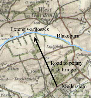 Kelso
was given liberty to make a bridge over the Blackburn
and to have a road to their petary. This was confirmed
about the year 1261. Kelso
was given liberty to make a bridge over the Blackburn
and to have a road to their petary. This was confirmed
about the year 1261.
Monastic Annals of Teviotdale, page
134, L. de Calchou charter
136, page 104
Interpretation
There is no indication in the charter of where the
bridge and road might have been though the fact that
the grant related to Mellerstain suggests the approach
was from the south.
Nenthorn
anciently called Naithansthirn
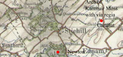 In
the late 1300's Kelso was gifted Camflat, in the territory
of Little Newton. It was bounded by Kelso parish on
the south, and on the north by Kanmuir moss, through
which there was a causeway and highway. In
the late 1300's Kelso was gifted Camflat, in the territory
of Little Newton. It was bounded by Kelso parish on
the south, and on the north by Kanmuir moss, through
which there was a causeway and highway.
Monastic Annals of Teviotdale, page
135; Liber de Calchou charter
521, page 411
Interpretation
At the time Nenthorn was centred on Newton which
is about one and a half miles south-west of a farm called
Kaimflat. Although no marshes are shown on modern maps
the ground may well have been water-logged in the middle
ages. The charter says the highway was a via regia which
suggests it was a through route although it is not clear
if it was a north south route perhaps between Kelso/Roxburgh
and Duns or an east west route perhaps heading towards
Coldstream.
Top
|
