|

The
text below is mostly summaries with some extracts from
the original text. The links are mostly to Google Books
with some to the EDINA site. These are usually to the
first item of interest rather than the first page of
a parish. The NSA for Argyllshire is volume
7. Some notes from volume 2 of MacFarlane's Geographical
Collections have been added - these are useful as they
date from the 1720's. See here
for further information and links.
Additional
information about parishes can be found on the Vision
of Britain site and on Scotland's
Places.
Some
old photographs from the Detroit Publishing Company's
Views of Landscape and Architecture in Scotland are
included - see thumbnails on Library of Congress site
here.
The
map of Kilninver parish is based on the quarter-inch
OS map The Southern Islands, 1923 and the other parish
maps and of the military roads are based on the map
by J.Arrowsmith,
1844, courtesy of David
Rumsey Historical Map Collection. The image is copyright
Cartography Associates but has been made available under
a Creative
Commons license for non-commercial use.
Overview
There are some references to the Romans
which have not been upheld by modern research. One is
for a presence on Lismore, another for a watch tower
above Dunoon. The latter is interesting as there is
an old road (Canmore
record) near Ardlamont
Point traditionally thought to be Roman and perhaps
running from the shore to a signalling point. Another
reference is to a "Roman" bridge south of
Inverary; however, while early, it is not Roman. A mistake
by antiquaries of the time placed a Roman town near
Benderloch, called Beregonium. There may in fact have
been a settlement here which was said to have two named
streets. There were causeways on Iona, including the
Street of the Dead.
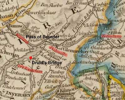
Other
unusual references are to the "Druid's Bridge"
on Loch Awe, which is a line of stones running into
the loch, and what is supposed to have been the start
of a bridge between Morvern and Mull. Coffin roads are
not mentioned explicitly but on Jura there were a couple
of caves used as corpachs where bodies being taken to
Iona could be kept if the weather was bad.
There
were a few small monastic settlements in Argyle in the
middle ages and it would be interesting, given their
record elsewhere if they made any lengths of road, although
none are mentioned or have come to light. A charter
of 1324 refers to a road being built between the two
Tarberts. The name itself, of which there are a couple
of instances, indicates a place where boats were dragged
across land to save a long sea journey.
Made
roads aside, it is clear enough that there were very
early communication routes in Argyleshire and that some
of the ferries existed from an early date. The paths
themselves were very rough, and it is interesting to
read of the Pass of Brander with its Ladder Rock. As
elsewhere in the west of Scotland, much of the travel
was by sea.
References
to made roads and bridges start appearing from the 1700's
with some roads being privately funded and others made
by the statute labour. This, however, varied between
parishes so that there could be reasonable roads in
one place and very poor roads in another. It is interesting
to see that Kintyre was completely cut off from the
rest of the county until the mid 1700's and that Kilfinichen
on the west side of Mull could only be reached by going
through a pass up Glenmore. Although a few good bridges
were made, bridges were generally fairly rudimentary,
perhaps just a tree trunk or a plank. From the complaints
about the impossibility of passing over swollen streams,
it is clear that travel was very difficult without bridges.
 |
| Military
Roads in Argyleshire. A number of the roads were
made in conjunction with the county - see W. Taylor,
The Military Roads in Scotland for details.
|
The
military roads were a major advance and opened up much
of Argyleshire. A road ran up Loch Lomond side to Arrochar
and Inverary, where the Duke of Argyle had his seat.
It was later extended up to Dalmally and Bonawe. Another
ran from Stirling through Callendar to Crianlarich and
Tyndrum from where it continued up to Fort William by
Glencoe and by a shorter route using the Devil's Staircase.
From Tyndrum there was a branch to the other road at
Bonawe. The line of road up the side of Loch Lomond
was later extended from Tarbert to Crianlarich where
the Fort William road was joined.
The
next major advance was work undertaken by the Commissioners
for Highland Roads and Bridges in the early 1800's who
remade existing roads and extended the network. Their
roads included roads on Islay and Jura, the Moydart
Road that ran through Ardnamurchan, roads south of Strachur
and one to Lochgoilhead, a road through Glendaruel and
a couple of roads in Arran. There were also improvements
to most of the military roads. By the time of the NSA
coaches were running on some roads, as well as carriers
though in coastal areas steamship services were often
more convenient.
There
are frequent complaints about the difficulties caused
by using peat as a fuel. In several places they were
becoming scarce and were often to be found at remote
locations along very bad roads which hurt the horses.
They took the best part of the summer months to gather,
time that would have been better spent on activities
that could improve their lands. Bad weather could lead
to the peats being ruined. Although coal was available
from the mainland, and a poor quality coal from Campbeltown,
many could not afford it partly because of freight charges
and partly because of a tax on coal.
There
were many ferries, those involving sea crossings being
very dangerous, though this situation improved somewhat
as steamships started making regular journeys from the
Clyde and elsewhere. The Crinan Canal had a major effect
on local economies, making it easier to send produce
to markets and bring in various goods. Droving was common
but it was soon found easier to take the animals by
steamship than long overland journeys. Ferries often
had inns associated with them, offering a place where
travellers could wait or sleep until it was safe to
make a crossing.
Other
sources
Agricultural Report - Argyle,
John Smith, 1813; see also 1798
Canmore search for Roads
in Argyleshire
The following are various interesting articles from
the Kintyre West Road website:
The
Campbeltown - Tarbert Mail Coach; The
Royal Mail; Kintyre�s
Roads; Kintyre's
Buses:Their History and Some Photographs; The
West Loch Ferries; The
Gigha Ferries;
The Tarbert Canal
W.
Taylor, The Military Roads in Scotland, House of Lochar,
1996
Roads in 1859
- link to website section
Various resources
- link to website section
Heritage
Paths - details of various historic routes in Argyleshire
Lost Argyll: Argyll's Lost Heritage, Marian Pallister,
Birlinn, 2005 - many useful references to roads, ferries
etc.
Google
Maps & Street View - view larger map and drag yellow
figure onto a highlighted road to see roadside view
View
Larger Map
MacFarlane:
Geographical Collections
Ane
Description of Certain Pairts of the Highlands of Scotland
(Volume
2)
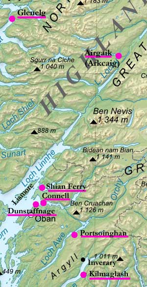 Page
145 Mention of ferries at Kilmaglash (Strachur) on Loch
Fyne and Port-Chregan on north side of Loch Fyne. Page
145 Mention of ferries at Kilmaglash (Strachur) on Loch
Fyne and Port-Chregan on north side of Loch Fyne.
Page 147 There is a ferry on Loch Awe at Portsoinghan.
The way there from Inverary is very dangerous in “time
of evil stormie weather and in winter”
Page 150 There is a ferry between Dunstaffnage and Gonnell
in Lorne (presumably North Connell) which is a very
difficult passage.
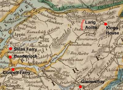
Page 154 Ferry of Sion (Shian Ferry) between Beandirloch
and the Appin.
Page 155 Ferry of Lismore.
Page 170 Glengarry “In the water or river of Airgaik
there was seen in the zeare 1620 yeirs the fourteenth
of August, the tennants and gentle-men of the Countrey
being at the building of a bridge of timber on the said
river, at the latter end of the making of the bridge,
there appeared Innumerable Adders in this water of Airgaick
Immediatlie efter the finitione of the said bridge.
The gentlemen and tennants perceiving the Adders and
all the water in such a pairt a litle above the bridge
full of cruell and terrible beasts and certaine of the
biggest of the adders did lope high above the water,
and certaine others of them comeing to the land, did
goe through the hadder and grass so fast that the whole
Companie which did behold,
were much affraied at this terrible and Marvelous sight.
And at last they were forced to leave their work and
depart from that place, which they did say, if there
had bein such sight at the beginning of the work, they
had never did it.” - see also page 524 below.
This may have been Loch Arkaig
- see map by Robert
Gordon and 1st edition of the 1" map, sheet
62
(Note: Map based on a map of Scotland
produced by Eric Gaba and made available on Wikimedia
under a Creative
Commons licence and Commons:GNU_Free_Documentation_License.
With thanks. See original on Wikimedia.)
Cowell
(some of these items are repeats of previous entries
above)
Page 511 Ferries mentioned: ferry of Lochfyne at Kilmaglais
which is 15 miles from Dunoon and Port Chregan on the
north side of Loch Fyne, three miles from Inverary.
There is also a ferry on Loch Awe.
Page
515 Ferry of Gonnaill in Lorne.
Page 516 Ferry of the Sian between Benderloch and the
Appin.
Ferry to Lismore from Appin.
Page
524 “Anno 1620 in the beginning of August, the
people of the countrey were building a bridge upon the
river Airkaig, at the end of the work they report they
saw an infinit number of adders swymming upon the water,
a litle above the bridge, leaping theron, wherof many
landing creeped away throch the grass and hather, to
the great terrour of the beholders, “

Ardchattan
OSA
Vol. 6, page 174 (also Muckairn)
Page 180 Roads, Services, and Fuel. The public
roads are much improved in recent years but the bye
roads especially those leading to the glens “are
rugged, slippery, and dangerous, lying in some parts
along the brink of precipices, and so narrow that two
men can hardly pass each other.”
The
statute labour is converted into money. Mostly peat
is used but much of the summer is wasted in obtaining
them. There is no prospect of improvement in the Highlands
unless the coal tax is removed.
Footnote:
Page 180 “In this district stood the famous
city of Beregonium: it was situated between two hills,
one called Dun Macsnichan, " the hill of Snachan's
son," and the other, much superior in height, is
named Dun bhail an righ, "the hill of the "king's
town." A street paved with common stones, running
from the foot of the one hill to the other, is still
called Straid-mharagaid, "the market street;"
and another place, at a little distance, goes by the
name of Straid namin; "the meal street."“
(Sited at Benderloch, about two and a half miles north
of Connel Ferry. See Canmore
entry, Site Number NM93NW 31, 6" map, Argyleshire
LXXXVII)
Page 182 Miscellaneous Observations. Connel ferry.
Although this ferry appears very dangerous no accident
has happened in living memory.
NSA,
468
Page 469 The island of Elanduirnish, in Loch-etive,
opposite to Bunawe, is inhabited only by the ferryman,
supports no more than a couple of cows and a few sheep,
and is connected with the mainland by a stone bulwark,
along which is conducted the public road, which, beyond
the ferry, diverges to Inveraray and Glenorchy.
Mention of ferries at Connell, Shian and Elan-duirnich.
Mention of King’s House about 7 miles from Buchail-mor.
Mention of the mountain pass of Larig-aoilt, which leads
to Glencoe.
Page 475 Connell ferry appears to be very dangerous
but the boatmen, with their skill and knowledge manage
the crossing safely.
Page 480 Mention of road between Glenorchy and Bunawe.
Page 494 Mention of high road connecting the ferries
of Connell and Shean. Connections with Ossian.
Page 495 Details of Priory of Ardchattan.
Page 505 Parochial Economy.
The nearest market town is Oban, 8 miles away by the
Connell ferry. Post office at Bonawe outwith the parish;
however, the Fort William post runs through part of
the parish.
Although there are no turnpike roads anywhere in Argyleshire,
the county roads and the bridge are in good order.
Page
508 Inns.—Of the five inns, four are at
ferries.
Fuel—Peat,
brushwood and some coal by those who can afford it.
Miscellaneous Observations.
Roads are required on both sides of Loch-etive, and
to be carried on from the head of that arm of the sea
to King's House, to unite there with the great road
from Fort William to Stirling and Edinburgh. Another
line is much wanted along the south side of Loch-creran,
already formed partially as far as Crigan ferry, that
road to be connected also with the great Edinburgh line.
 Ardnamurchan Ardnamurchan
OSA
Vol. 20, page 286
Page 296 The annual road money for Ardnamurchan is L9.2s.
and L4.7s for Sunart. There is a post office in Strontian.
NSA,
117
Steamers between Glasgow and Skye and the Long Island
call at the Point of Arasaig.
Page 152 A few years ago the British Herring Fishery
Society built two piers on the “north and south
sides of a neck separating Loch Sunart and the bay of
Kintra” with a connecting road through the moss
of Kintra. It was hoped that as it avoided Ardnamurchan,
people would use it for journeys between north and south.
Page
155 Parochial Economy.
Market-Town.—The nearest is Tobermory, in Mull,
5 miles south of the harbour of Kilchoan in Ardnamurchan.
Post-Offices.— Strontian with a daily post,
Arisaig with a thrice weekly service; and Kilchoan served
by runner from Strontian twice a week.
 Means
of Communication.— There are about 60 miles
of road although more are needed to cover the area.
One road runs from “Arasaig by Glenfinnan on
the north, to Fort-William and the Caledonian Canal;
and that from Strontian on the east, to Corran Ferry.
By these, cattle and sheep are driven to the southern
markets.” Means
of Communication.— There are about 60 miles
of road although more are needed to cover the area.
One road runs from “Arasaig by Glenfinnan on
the north, to Fort-William and the Caledonian Canal;
and that from Strontian on the east, to Corran Ferry.
By these, cattle and sheep are driven to the southern
markets.”
The
main mode of transport is steamship. Glasgow steamers
land at Tobermory and at the point of Arisaig with the
necessary items for the parish and return with some
animals and many eggs.
Harbours.—He
gives details of anchorages and harbours. That at Kilchoan
is used to reach Tobermory and sometimes boats from
the islands land cattle there. As said, there is a small
harbour on the north coast; and there are landing places
in Loch na Keaull in Arisaig and in Loch Sunart. Glasgow
steamers have been calling at these places.
Page 162 Fairs.—Fairs for the sale of cattle
and sheep are held at Strontian and Arisaig. People
from Morven and Kilmalie attend the Strontian fair.
Inns.—Good inns at Strontian, Arasaig, and
Glenfinnan, and four lesser establishments elsewhere.
 Campbelltown Campbelltown
OSA
Vol. 10, page 517
Page 550 Produce is sent from here to the Clyde by regular
packet-boat services.
Minerals, Fuel, Etc.—There is coal three miles
away from which a canal runs to the town. Turf and peat
is used in the country and by the poorer people in the
town.
Page 559 There is a post office. Contrary to former practice
this office no longer delivers letters in the town or
on the route taken by the runners; now one has to continually
enquire at the post office if there is any mail otherwise
letters may be returned as dead.
Page
566 The tax on coal carried coastwise causes much hardship
and should be abolished if improvements are to be hoped
for. Too much time is spent obtaining peat which would
be better spent on improving the land. Where it has been
worked out, great hardship is caused if coal cannot be
afforded. In a footnote he says that the tax has now been
abolished.
NSA,
453
Page 457 A canal has been cut to coal works three miles
from Campbeltown.
Page 463 Details of the trade carried on through the
port - Glasgow easily reached by steamer.
Page 465 Turnpike Roads.—None. The roads
and bridges are good and mostly statute labour.
Fairs.— Four annual fairs.
Inns, Etc.—There are 76 public-houses and
two excellent inns in the town.
Fuel.— As well as peat, coal obtained locally
and from Glasgow and Ayrshire is used.
1843
 Craignish Craignish
OSA
Vol.7, page 436
Page 441 “Carts have been lately introduced; and
more would be used, were the roads made passable for such
carriages. But these are quite neglected. The statute
labour is not employed on them; and it is probable the
commutation for it will not for some time produce any
material alteration.”
One inn.
Page 446 Advantages and Disadvantages. Peat is
scarce and of poor quality. Coal is expensive both because
of the coal tax and the cost of transport round “the
point Kintyre.” This would improve if the coal tax
was abolished and a canal built at Crinan.
He lists the other advantages that would result from such
a canal. He remarks on the danger to those in open Birlins
rounding the Mull of Kintyre which leads to them unloading
their cargoes in West Loch Tarbert and dragging these
and their boats across to the eastern shore to make their
way to the Clyde.
NSA,
45
Page 57 Navigation.—Sheep and cattle from
Jura with some from Islay and Colonsay are carried to
the mainland for the markets of Dumbarton, Doune, and
Falkirk
Occasional
visits from vessels from Glasgow and Greenock that land
coal and ship potatoes. A few boats also come from Ireland
for seed potatoes.
Parochial Economy. Although there is no market
town there are frequent markets held at various places,
particularly at Lochgilphead.
Means
of Communication.—
“The road between Lochgilphead and Oban passes
for two miles through the parish. From this the parish
road branches off to the south-west, and proceeds, for
the most part, along the eastern shore to the harbour
of Little Loch Craignish. Bridges have been erected
where necessary.”
“The
Crinan Canal affords the means of easy and frequent
communication with the low country. Steam-boats plying
through it between Glasgow and Inverness pass the southern
extremity of the parish every alternate day, and often
land goods and passengers.”
Page
59 Inns.—Three.
Fuel.—Mostly peat but coal is brought from
Glasgow in the summer.
Miscellaneous
Observations. The roads are much improved and the
Crinan Canal has resulted in distinct economic advantages
when disposing of agricultural produce and obtaining
commodities from the low country.
Revised 1843
 Dunoon
and Kilmun Dunoon
and Kilmun
OSA
Vol. 2, page 383
Page 385 “In former times, the ferry at Dunoon
was the principal inlet from the low country to Argyleshire.”
There is now “a great road being carried by Lochlomond,
round the head of Lochlong, and through Glencroe to Inverary".
Page 389 Fuel.—Mostly peat but some coal for
those who can afford it or those living by the shore who
find it more convenient and not subject to the problems
affecting peat when the weather is bad.
NSA,
567
One of the proprietors is required to maintain a ferry
over the Clyde as part of a feudal tenure.
Page
570 He makes the point that a valley has an entrance
and exit and a glen has an entrance but no exit at the
other end, or at least a barrier which makes exit difficult.
In
describing the geography of the area he notes that the
valley of the Eachaig, past Loch Eck to Strachur is
only 18 feet above the sea and affords an easy communication
between Inveraray, the county town, and the south of
Scotland, and quite practicable for a railway
 Page
577 Hydrography.—There is a ferry over to
near the Cloch lighthouse, a journey of about 3 miles.
The ferry is not so busy since steam ships started sailing. Page
577 Hydrography.—There is a ferry over to
near the Cloch lighthouse, a journey of about 3 miles.
The ferry is not so busy since steam ships started sailing.
Page 596 He describes remains on the farm of Ardinslat
that may be Roman and surmises that it may have been
a signal tower erected when the Antonine wall was building
to warn of any danger approaching from the sea.
He also refers to the tradition that Agricola had his
fleet sail up Loch Fine, and that traces of them having
landed at Otter have been found.
(Note: One Canmore
record (NS17NE 2, NS1796 7868 -Castle Crawford)
for the remains is somewhat ambiguous about their date
but does not assess them as Roman; another (NS17NE
25) says they are definitely not Roman. For an intriguing
account of supposed Roman advances in Argyleshire, see
Hector Boece’s History,
book IV, section 37-39. This very conveniently fills
a gap in our knowledge of Roman movements but it is
far from clear if it is historically accurate.)
Page 608 Before steam navigation journeys from here
and neighbouring areas could be very difficult and sometimes
dangerous. He gives two instances of this. One was that
24 years before, the minister of Rothesay took three
days to sail to Greenock; the other from 32 years before
was of a journey down the Clyde from Glasgow to Gourock.
The first day was spent in reaching Bowling, the second
being unable to make headway against the wind and having
to spend another night at Bowling. On the third day
the boat reached Port Glasgow where he disembarked in
disgust and continued the journey by post-horse. He
returned to Glasgow by land. The cost of the journey
was L.7. 14s. Rothesay to Greenock now takes 2 hours
and Glasgow to Gourock in just over 2 hours and costs
only one shilling for each journey. It takes 3 hours
between Dunoon and Glasgow by boat and if the railway
is used two hours, and a further two hours to Edinburgh.
Page
618 Navigation.—Two very convenient piers
have now been built at Dunoon and at Kilmun.
Parochial
Economy.
There is no proper market town but Dunoon and Kilmun
serve as such.
There are post offices at Dunoon, Kilmun, and Ardentinny,
with daily services
There
are 49 miles of road in the parish. None of the roads
in Argyleshire are turnpike. The lines of road here
are:
 •
A road along the coast (presumably from parish boundary
at the Ardyne Burn near Castle Toward) to the boundary
of the Glenfinart estate. The part from Strone Point
up to Glenfinart estate was made by subscription last
year. (Note: This whole line of road is shown on Langlands
map of 1801 (SW sheet) so this section may refer
to an improvement of an existing road). •
A road along the coast (presumably from parish boundary
at the Ardyne Burn near Castle Toward) to the boundary
of the Glenfinart estate. The part from Strone Point
up to Glenfinart estate was made by subscription last
year. (Note: This whole line of road is shown on Langlands
map of 1801 (SW sheet) so this section may refer
to an improvement of an existing road).
•
A road from the south of Loch Eck up to Whistlefield,
made a few years ago by subscription. It gives access
to Strachur, Inverary, and western Argyleshire.
 •
A road from Kilmun to Loch Eck. It is thought that the
first steam carriage to run on a public road in Scotland,
ran on this road. It, along with a plan for a steamer
on Loch Eck was abandoned. •
A road from Kilmun to Loch Eck. It is thought that the
first steam carriage to run on a public road in Scotland,
ran on this road. It, along with a plan for a steamer
on Loch Eck was abandoned.
There
are now much-needed wooden bridges on the Eachaig, the
Little Eachaig, and the Massan. The roads are generally
good: they are statute labour which is commuted although
it is felt that too much of the burden rests with the
poorer people. An Act currently before Parliament will
remedy this.
“The
Holy Loch is the only harbour or good anchorage along
the coast of the parish.”
Good
as the roads and bridges are we are even better served
by frequent and fast steamer services from Glasgow and
Greenock and Rothesay and the western parts of Argyleshire.
Page 628 Inns, Etc.—Two in Dunoon,
one in Kilmun, and one in Ardentinny, and 18 other places
where drink can be obtained.
Fuel.—Mostly coal from Glasgow along with
some from Ayrshire. Peat is still used in the upland
areas, although they prefer coal.
Miscellaneous Observations. He refers to the
major benefits of steam navigation.
 Gigha
and Cara Gigha
and Cara
OSA
Vol.8, page 37
Page 43 Roads and Ferry.— “From the
harbour of Gigulum sound, there is an excellent line of
carriage road, finished half-way to the north end of the
island, which will soon be completed the whole length,
to the great convenience of the inhabitants, who are now
beginning to use carts, of which there are already six
in the island. The statute labour for making roads is
converted into money at the rate of 1s. 6d., or 2s. for
each person annually. Besides this fund, there is a shilling
in the pound, valued rent, payable over the whole county,
by an act of Parliament passed in 1774; but the money
thus raised, goes to the great lines of road (particularly
specified in that act) on the main land; and as these
are still incomplete, nothing of the money exigible by
the act of Parliament, can be applied to other places
and consequently the road in Gigha has been carried on
at the expense of the principal proprietor.”
A
ferry runs between Gigha and the mainland. Difficulties
are caused however by there being no quay on the exposed
Kintyre side which means the boat has to be drawn up
on the shore in bad weather, and there being no place
where passengers can wait.
Page 56 At a narrow part of the island there is a place
called Tarbet that may indicate ships were dragged overland
here.
Page 69 Proposed Improvements. Benefits would
result from reviewing the tax on coal and salt; building
towns; and making canals at Crinan and between Inverness
and Fort William.
NSA,
394
Page 396 Vessels call in at the Bay of Ardminish, with
coal and lime etc and take away produce.
Page 400 Antiquities.— There is a signal
post on a hill at the north of the island used to advise
the Islay steamer of any passengers. Its name, meaning
"watch cairn" indicates that it was long used
to give warning of invasion.
Page 404 Mention of a new road to the mill, that cost
L.250.
Page 405 We export potatoes, bear, oats, cattle, horses,
pigs and sheep and dairy produce.
Parochial Economy.
Market- Town. — “Campbelton is the
nearest market-town. The produce of the island, however,
is carried by water to Islay, Ireland, and the Clyde;
but the price of agricultural produce is much the same
here as at Campbelton.”
Means of Communication.—A steamer between
West Loch Tarbert and Islay, passes the north end of
Gigha, where a boat takes off passengers.
“There is a ferry to the mainland from each
of the properties. The fare of the boat is 2s., or 6d.
each, if there should happen to be more than four passengers.”
There is a receiving house at Tayinloan which is 18
miles from the post-office in Tabert. Besides Tarbert
the mail is also taken to Campbelton. There is also
a weekly carrier to Campbelton.
Gigha has 5 miles of carriage road and two miles of
cross-road from this to the corn-mill. It is hoped to
take the road to the north end of the island. Quays
are needed at both ends and at Tayinloan.
Page
407 Inns.— One
Fuel.— Mainly turf but as it is scarce,
coal from Ayrshire and a poorer coal from Campbelton
is becoming more common.
Miscellaneous Observations. Building good roads,
dikes and one or two quays would encourage industry.
 Glassary Glassary
OSA
Vol.13, page 653
Page 657 A number of individuals here are employed in
making roads, fences, ditches etc for part of the year.
Page 662 There are 3 forts that appear to have been watch-towers
from which signals of invaders could be made.
 Page
663 Roads and Bridges.—As the roads here and
most other places in the county had been badly made and
maintained by the statute labour, the heritors of the
county obtained an act about 20 years ago for new roads
to be made in the county and setting an assessment. This
project was entered into with great enthusiasm by many
heritors many of whom advanced 15 years assessment. This
happened in this parish with some advancing additional
funds so that in a few years 12 miles of road, 24 feet
wide were made as part of the road from Inverary to Campbelltown,
and 6 miles from Lochgilphead as part of the road leading
up towards the Lorn district. Page
663 Roads and Bridges.—As the roads here and
most other places in the county had been badly made and
maintained by the statute labour, the heritors of the
county obtained an act about 20 years ago for new roads
to be made in the county and setting an assessment. This
project was entered into with great enthusiasm by many
heritors many of whom advanced 15 years assessment. This
happened in this parish with some advancing additional
funds so that in a few years 12 miles of road, 24 feet
wide were made as part of the road from Inverary to Campbelltown,
and 6 miles from Lochgilphead as part of the road leading
up towards the Lorn district.
Although there is presently a shortage of funds for repairs,
due to such rapid progress, it is expected that this situation
will improve and allow the high roads to be maintained
and the by roads finished.
Most of the bridges were built in the same way, the heritors
advancing the money to the contractors, until the funds
would allow them to be repaid. In the meantime, they have
been compensated by the use of the roads and seeing how
useful they were to the district.
Advantages
and Disadvantages.— The roads have been a great
help to the parish.
Peats are used but in some places are very scarce or
exhausted. Now that the duty on coal is removed, it
would be a further help if that on salt was also removed.
We would hope to benefit from the canal proposed at
Crinan.
NSA,
675
Page 685 There are several ruined chapels in the parish
including the one at Kilneuair on Lochaweside (just
over 1 mile east of Ford). There is a tradition that
the stones were dressed at a quarry near Killevin on
Lochfineside, 12 miles from the chapel, and that the
people then formed a line along which all the stones
were passed from hand to hand until the chapel was complete.
There was once a village here where a market called
A'margadh Dhu was held. “Now the ruins stand
alone by the side of a road which few travellers frequent.”
Note: The chapel at Killnevin (NR
986 972) is thought to have been the original parish
church for Kilmichael Glassary and which was moved to
Kilneuair; the tradition suggests the stones were reused
- see Canmore
record. There is no indication of the route
that might have been taken.
692 Parochial Economy. Market-Town.—Lochgilphead
is the main market-town and has excellent communications
by steam-boats which call in at Ardrisaig, 2 miles away,
and which serves as its port. Glasgow is easily reached
as are Mull and Inverness by the Crinan Canal, and Inverary.
Cattle and sheep can easily be taken to market.
There is a regular postal service to Inverary, Glasgow,
Campbelton, and Kilmartin.
Although
there are no turnpikes the roads, of which there are
21 miles, are very good. They are funded by assessment
in the county. There is however a need for more in the
northern part of the parish.
There are also some very poor public roads: one is through
the valley of Glassary, another runs from the ford to
Inverary, and another from Bravealaich to Inverary.
A road along the side of Loch Awe from Eritinn to Fionchairn,
a distance of 8 miles was made last year at a cost of
L1500 and was “offered gratuitously to the road-trustees
by the proprietor of the lands in that district.”
"The
bridges are not remarkable, but they are in good order,
and that over the Ad, having four arches, is the largest.
Notwithstanding that it has been enlarged and repaired
at different times, it is still very narrow, steep,
inconvenient, and almost dangerous. A new bridge lower
down would require a mile of new road; but would shorten
the distance to Kilmartin considerably, and ought to
be built. One of the swing bridges over the Crinan Canal,
that at Carn-ban, is in this parish; but none of them
is quite trustworthy, and when vessels are passing there
is a long detention.”
“There
is a small pier built by the road trustees at North
Ottar Ferry, and I have a small pier for my own use
below the house, with a causeway or ' hard,' 300 yards
long down to the lowest low water mark. I have also
rather a larger pier at the village for the accommodation
of herring wherries, coal smacks, &c. from whom
I take a small toll.”
Note: The above two paragraphs are
from a communication from Sir John Orde, Bart.
Page
698 Fairs.—Four fairs at Kilmichael and
Lochgilphead.
Inns and Alehouses.—Thirty, with 23 in Lochgilphead.
Page 700 "If Lochgilp was dredged, vessels could
reach the village.“
 Glenurchy
and Inishail Glenurchy
and Inishail
 |
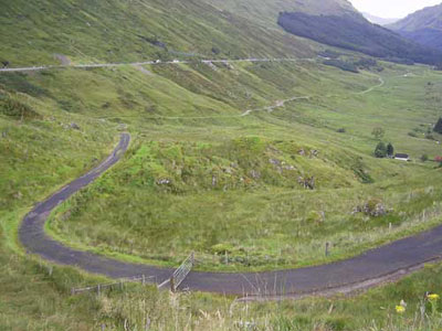
| Bridge of Orchy. This used to
carry the main road north but it terminates at Forrest
Lodge. Beyond that point it is used as the West
Highland Way. A military road also passes through
here. |
OSA
Vol.8, page 335
Page 340 Mention of hawkers selling goods, as well as
a shop.
Page 344 Roads and Bridges—
"In
no county has more been done, during the last 20 years,
in constructing bridges, and forming useful lines of
road, than in the shire of Argyll within that period,
besides what has been effected by the statute labour,
and by a yearly assessment of above 600 L Sterling on
the valued rents, many expensive bridges and various
lines of roads, have been completed by large subscriptions.
 Glenorchay
is every where well accomodated with good roads and
convenient bridges. The great military road from Stirling
to Tayndrom and Inverary, passes through the parish,
from one extremity almost to the other: as does also,
for many miles, the military road, from Tayndrom to
Fort-William. In the original formation of these roads,
the obvious and proper line has not always been selected.
The traveller often feels, to his cost, that the road
was brought to the gravel, and not the gravel to the
road. A more enlightened and liberal system of road-making
is now adopted; and, it is hoped, that the line will
be altered from its present incommodious acclivities
and descents, wherever a more easy and level road can
be formed. Glenorchay
is every where well accomodated with good roads and
convenient bridges. The great military road from Stirling
to Tayndrom and Inverary, passes through the parish,
from one extremity almost to the other: as does also,
for many miles, the military road, from Tayndrom to
Fort-William. In the original formation of these roads,
the obvious and proper line has not always been selected.
The traveller often feels, to his cost, that the road
was brought to the gravel, and not the gravel to the
road. A more enlightened and liberal system of road-making
is now adopted; and, it is hoped, that the line will
be altered from its present incommodious acclivities
and descents, wherever a more easy and level road can
be formed.
 From
the inn of Dalmaly, to the bridge of Aw, a very judicious
alteration in the line of public road has been lately
made, at the expense of above 400 L. Sterling. This
beautiful line winds, for miles, through woods and dells,
presenting such varied and agreeable views of water,
of islands, of towering mountains, and sloping hills,
as give an uncommon grandeur and sublimity to the landscape.
Part of the road lies through a narrow defile, amidst
such irregularities of nature, such deep chasms, and
such impending rocks, as indicate some vast convulsions
of the earth, to have happened at some remote period
of time." From
the inn of Dalmaly, to the bridge of Aw, a very judicious
alteration in the line of public road has been lately
made, at the expense of above 400 L. Sterling. This
beautiful line winds, for miles, through woods and dells,
presenting such varied and agreeable views of water,
of islands, of towering mountains, and sloping hills,
as give an uncommon grandeur and sublimity to the landscape.
Part of the road lies through a narrow defile, amidst
such irregularities of nature, such deep chasms, and
such impending rocks, as indicate some vast convulsions
of the earth, to have happened at some remote period
of time."
 Page
350 Inn.—In referring to the excellent inn
at Dalmally he praises the efforts of Lord Breadalbane
who had done so much for the convenience of travellers
on the road between Perth and Inverary by building a
number of good inns on his lands. Page
350 Inn.—In referring to the excellent inn
at Dalmally he praises the efforts of Lord Breadalbane
who had done so much for the convenience of travellers
on the road between Perth and Inverary by building a
number of good inns on his lands.
Page
351 Well of St. Connan.—Some 20 years ago
an old man who lived near the well of St Connan which
is close to the inn at Dalmally used to give “passengers
a drink from his favourite spring, for which he received
some small consideration.”
Page
357 Fuel.—The main fuel here is peat. If
these are damaged by wet weather the consequences can
be severe. “A few years ago, many poor people
in the West Highlands were obliged to burn most of their
household furniture, to repel the cold and to prepare
their food. Old people and young children, unable to
bear the cold, were mostly confined to bed.”
NSA,
82
Ruins of a Cistercian nunnery at Inishail (see also
page 97).
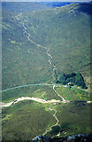
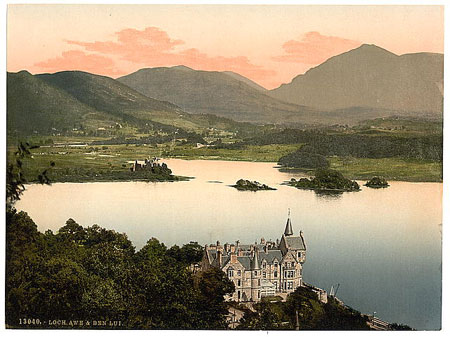
Page 88 In a poetic description of the pass of Brander
he says that “until the present line of road was
executed, it was impassable to any except the sure-footed
and steady-headed mountaineer.” He says that at
one point (the ladder rock) a rock had to be climbed
by a ladder (note: it is more likely
that the name comes from the Gaelic leiter and refers
to a slope). The road gives access to the
sea at Bunawe from where produce can be taken to the
markets in the south.
Page
92 About a century before, much timber felling was carried
out. The timber was floated down the Urchay when high
enough to Loch Awe where it was made into planks then
floated in rafts to the pass of Brander then carted
to Bunawe on the coast.
There is a huge oak trunk that was used to bridge the
river below Achallader until the river changed its course.
Page
98 “Tradition alleges, that a bold attempt was
once made to throw a bridge across Lochawe, a little to
the north of Cladich. On the south side of the lake, on
the farm of Barandryan, huge blocks of stone may, on a
clear and calm day, be traced into the lake to a considerable
distance, placed, it is said, at regular distances. These
stones and cairns, the foundation on which the intended
bridge was to have rested, constitute the sole remains
and monument of this formidable undertaking. These remains
are called the Druid's bridge.” (Drochaid nan
Druidh, see 6" map, Argyleshire
CXIII, NW quadrant)
Page 100 Since the last account the inn at Dalmally has
been enlarged and new inns built at Cladich and the south
side of Portsonachan ferry. The roads are well maintained
and conveyances and post-horses are available at the inns.
Page 103 Fairs.—Two.
Inns.— "There are inns, and two small
dram-houses in the parish."
Fuel.— Turf and peat.
1843.
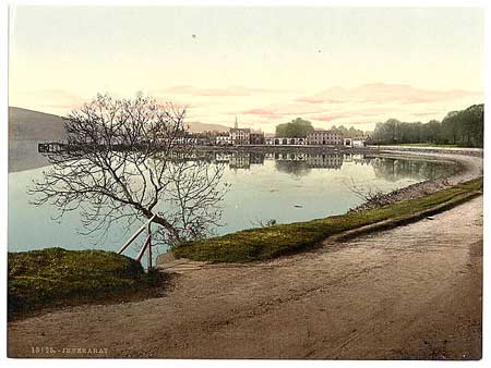
 Inverary Inverary
OSA
Vol.5, page 287
 Page
289 Only the affluent can use lime as a manure because
of the cost of coal, and other fuel to burn the limestone
being scarce. The coal tax is a great impediment to any
progress. Page
289 Only the affluent can use lime as a manure because
of the cost of coal, and other fuel to burn the limestone
being scarce. The coal tax is a great impediment to any
progress.
Page 291 “The harbour of Inverary was anciently
called Slochk Ichopper, which means the Gullet where vessels
bought or bartered for fish… It appears, that anciently
the French merchants used to come and barter their wines
for herrings, as there is a point of land, about 3 miles
south of Inveraray, still called the Frenchman's point;
and the tradition of the country is, that it was to that
particular spot the herrings were in use to be brought,
in order to be cured and sold.”
In a list of occupations there are listed 1 innkeeper,
2 ferrymen, 3 carters, 4 messengers.
Page 294 Details of the town of Inverary.
Page 303 Mention of the bridge of Douglas.
Page 304 Before the 1745 the mail was brought by a weekly
runner from Dumbarton but the service did not pay. Now
there are 6 deliveries a week and 10 post offices in the
county, an indication of its progress.
Inverary has one main inn and several lesser public houses.
 NSA,
1
NSA,
1
Page 6 The father of the present Duke of Argyll made a
carriage road to some waterfalls in Glenshira.
Page 7 There are 2 wooden and 3 stone bridges over the
Aray.
Page 13 Mention of the Foal's Bridge, or Drochaig an tshearraich,
near to an avenue that led to the Duke’s offices.
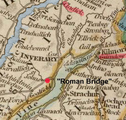
Page 26 There is a very old bridge over the Douglass on
the road to the house of Claonary, 3½ miles west
of Inverary. It is called the Roman
Bridge.
Page 35 Inverary has a weekly market and three annual
fairs which at one time were the only fairs allowed in
the county.
Means
of Communication.—Glasgow can now be reached
in 7 hours instead of the two days it used to take.
There are four routes: by Lochgoil; the Kyles of Bute;
Cairndow and Lochlomond; Locheck and Kilmun. In summer
there is a daily coach to Oban, and ample means of posting.
There are posts by Cairndow, Cladich, and Lochgilphead.
The roads in Argyleshire are not turnpike: they were
originally military and are now funded by the county
(two-thirds) and the government (one-third). The government
also meets the cost of superintending and inspecting
these road by commissioners for highland roads and bridges.
There are 10 miles of a former military road here, and
another of 8 miles which is wholly funded by the county.
In addition the Duke of Argyle had made and maintains
some 36 miles of road.
Page
43 Inns, Etc.— 14.
Fuel.— Coal is brought from Glasgow, Ardrossan,
and other places. Turf or peat is used in inland areas.
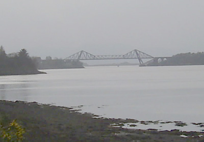
 Inverchaolain Inverchaolain
 |
| Looking
over to Loch Striven from Rothesay. Inverchaolin
parish is on both sides of the loch. Dunoon and
Kilmun parish on right of photograph. |
 OSA
Vol.5, page 464 OSA
Vol.5, page 464
No particular mention of roads.
NSA,
108
Page 114 Mention of droving.
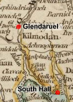
Means of Communication.—Of the 30 miles
of road, the road from South Hall to Glendaruel is well
maintained; the other roads are inferior. The roads
are statute labour.
Fairs, Etc.—One fair, four public houses.
Fuel.— Mostly coal but also some peat which
is hard to obtain.
1843.
 Jura Jura
OSA
Vol.12, page 317 (Jura & Colonsay)
Page 321 Sea-weed used as manure.
Page 330 Antiquities, Etc. There was a monastery
of Cistercians in this island. Their abbey stood in Colonsay,
and its priory in Oronsay.
Page 331 In a reference to his salary he mentions the
difficulties arising from having to pay his assistant
two-fifths out of his salary, among them incurring the
expense and danger of crossing broad perilous ferries
to marry and baptize in the other islands.
Page 332 Advantages and Disadvantages.—Among
its disadvantages are its remoteness and the difficulties
faced by its ferries.
There are also a number of rivers that are not bridged
and impassable when it has rained. More than half of the
peat last year was ruined by the bad weather; there is
a need to remove the duty on coal so that it can be more
affordable.
 NSA,
534
NSA,
534
Page 535 On the west side of the island where there are
many caves, two are called corpachs, “i.e. places
where the inhabitants of Jura and other countries, on
their way to Oransay and Iona to bury their dead, were
in the habit of depositing the corpses of their friends,
until a favourable opportunity of prosecuting their voyage
to Iona and Oransay occurred. One of these corpachs is
in Rhuintalen, opposite to Colonsay: the other, called
the corpach of I Columkill, is several miles to the north-east,
along the coast.” (See 6" maps Argyleshire
CLXVII
& CLVII)
Page
539 Mention of road from Lagg to Feolin Ferry
Mention of ferries.
Page Mention of bridges having been built.
Parochial Economy.
Harbours.—There is a quay at Small Isles Harbour.
Page 543 Means of Communication.—There are
ferries at “Kenuachdrach, to Craignish; the
ferry of Lagg, to North Knapdale; the ferry of Feolin,
at the Sound of Islay, situated at the south end of
Jura, and directly opposite to Portaskaig, in Islay.”
There is a good government road between Feolin and Lagg.
Mr Campbell has been making bridges, and roads to the
main farms on his property.
Mail is landed at Lagg where there is a sub-office then
taken by runner to Feolin Ferry.
Inns
and Public-Houses.—Two.
1843.
Colonsay and Oronsay
Name.—“These islands form one island
when the tide retires, but are separated at flood-tide
by an arm of the sea a mile broad, where it is usually
crossed. At the point where they approach nearest, the
islands are not above 100 yards apart.”
Antiquities. Priory of Oronsay settled from Holyrood.
The first road in Colonsay was made at the cost of the
present proprietor with the aid of the statute labour.
Parochial Economy. Harbours.—There is a
good harbour in Colonsay with a quay and a road leading
to it.
Inns, Etc.— Inn near the harbour.
1844.
 Kilbrandon
and Kilchattan Kilbrandon
and Kilchattan
OSA
Vol.14, page 157
Page 161 Details of the slate quarries of Easdale.
Page 163 He refers to the difficulties caused by having
to use peats as fuel, noting that although the removal
of the coal duty has been helpful its cost is still high
because of freight and insurance, and that the poor may
still not be able to afford it yet live in an area where
peat and turf are scarce.
Page 164 Public roads are daily improving. Statute labour
is commuted.
Page 168 Remains of a few forts thought to be Danish and
to have served as watchtowers as well as places of defence.
NSA,
71
Page 72 “The Sound of Clachan, which separates
Seil from the mainland, is only a few yards in breadth.
It runs nearly in a straight line for about two miles,
and might be taken for an alpine river. A bridge was
built across this sound fifty years ago, being perhaps
the first instance of the kind in Great Britain where
an island was thus joined to the mainland. This bridge
is 70 feet wide, and 26 feet above high water mark,
so that small vessels of twenty tons burden may pass
under it.”
Page 77 Details of the Easdale slate quarries which
had been working for 200 years.
Page 78 Parochial Economy.
Market-Town.—The nearest is Oban, 16 miles
to the north. Steamers from Glasgow to the north pass
through the Sound of Easdale and can be used as required.
“In this village there is an inn, several shops,
and a post-office. There is a daily post between Easdale
and Oban.”
Roads.—“The parish is well supplied
with roads and ferries. The public road from Oban enters
the parish from the northeast, at Clachan Bridge. It
passes through the centre of Seil and Luing. There are
several cross roads, which are kept in good repair.”
Ecclesiastical State.— Mention of the Ferry
of Cuan near the church on Seil.
Page 81 Fuel.—The quarriers at Easdale use
coals from Glasgow. The farmers use peats, though these
are becoming more scarce.
1843.
 Kilcalmonell
and Kilberry Kilcalmonell
and Kilberry
OSA
Vol.10, page 54
Page 56 Canal, Roads, Etc. In writing about the
projected canal at Crinan he argues that a canal would
be better sited at Tarbert.
“There are three good lines of road in the parish,
kept in repair by an equivalent, paid for the statute
labour. One of them intersects the peninsula of Kintyre,
at the distance of six miles from its isthmus. The other
two are on the opposite shores of Loch Tarbert, parallel
to its direction; and, for the most part, through, the
fine natural woods with which its sides are adorned.”
 Page
60 Shell fish sent to market at Greenock and Campbelton. Page
60 Shell fish sent to market at Greenock and Campbelton.
Page 61 He refers to the efforts of the late Sherrif Stonefield
to improve roads in Argyleshire.
Fuel.—Although
some have peat near at hand it is still a time-consuming
and expensive business to obtain and prepare it, and there
is always the danger that it will be affected by rainy
weather. The removal of the coal tax would help.
Advantages and Disadvantages.—The roads are
good and there are good communications with the low country
and the Western Isles by weekly packets to the lochs of
East and west Tarbert. The post comes three time a week.
A list of occupations notes there were 3 posts, 1 post-master,
5 shopkeepers, 2 innkeepers,
NSA,
408
A large quantity of potatoes is exported annually for
the English and Irish markets.
Page
411 Parochial Economy. Tarbert is a post-town
receiving mail from Glasgow and forwarding it to Campbelton
by land. It is “probably the ancient county town
of Argyle.”
Ale-houses.—About a dozen.
1843
Origines
Parochiales Scotiae Vol
II, Part 1, page 33. In 1325/26 a road was made
between the two Tarbarts.
 Kilchaoman
(Islay) Kilchaoman
(Islay)
OSA
Vol.11, page 276
Page 276 Quay at Bowmore.
Page 278 Black Cattle.—Black cattle are taken
by drovers to Dumbarton and Falkirk, and sometimes England.
Page 281 "Almost every farm has peatmoss within
itself, of an excellent kind, affording charcoal for the
smith, as we have no coals. These peats, with the fish
oil they burn in lamps, make the habitation of the meanest
cottager warm and cheery."
Page 282 Roads and Bridges. The roads on Islay
are the best in the Western Isles. They are done by the
statute labour work and a carriage can be driven 30 miles
through the island. A packet, funded by the country and
the government, goes to and from the mainland each week
with the mail, passengers, and goods.

NSA,
644
Page 655 Parochial Economy. Means of Communication.—
“There are twelve miles of a Parliamentary line
of road in the parish, and thirty-four miles of statute
labour road, all kept in a state of good repair. With
three exceptions, the public road passes through every
farm in the parish.
Bowmore, the nearest market town, is twelve miles distant.
The post-office is at Bridgend, nine miles distant.
The letters are brought thence by a private runner.
The mail is received and despatched four times weekly,—twice
by a steam packet, and twice through Jura by the ferries.”
Inns.—Of
the seven public houses, only three are respectable.
Fuel.— Mostly peat but some use coal brought
from Glasgow.
Miscellaneous Observations. “A powerful
steam packet plies regularly between the island and
Tarbert. Districts almost inaccessible are now opened
up by means of good roads…..”
1839, revised 1844
 Kilchrenan
and Dalavich Kilchrenan
and Dalavich
OSA
Vol.6, page 266
Page 266 Coals are extremely expensive owing to a heavy
tax and an expensive transport by land, there being no
sea coast here. This is particularly serious when peats
cannot be cut because of bad weather.
Page
269 Woods, Inns, and Roads. Wood here is sold to
the Lorn and Argyll furnace companies.
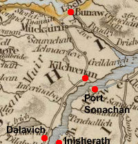 “There
are 2 inns in the parish; one of them a very good house,
with stables and boats at the ferry of Portsonachan, upon
the shortest road to Bunaw and Oban. This road runs along
the water of Naint through the romantic forest of Muckairn.” “There
are 2 inns in the parish; one of them a very good house,
with stables and boats at the ferry of Portsonachan, upon
the shortest road to Bunaw and Oban. This road runs along
the water of Naint through the romantic forest of Muckairn.”
“The roads of this district are very bad, the statute
lahour having been suffered to be expended on lines of
road thought more immediately necessary, out of the parish,
for many years.”
“At the south end of the parish, Mr Campbell of
Kilmartin and Mr Campbell of Inverliver, have advanced
considerably in carrying on the line of road along the
west side of Lochow, as Mr Campbell of Sonachan has done
on the east side.”
A list of occupations notes 3 packmen, a carrier, and
ferrymen at Portsonach and at Inisherath.
NSA,
372
Page 375 There are two churches here for both parishes
which are about 9 miles apart. Occasionally the Minister
will have a service at both on the same day but the
distance and the state of the roads makes this difficult.
Three inns.
 Kildalton Kildalton
OSA
Vol.11, page 286
Page 287 Creels on horseback are used for carrying manure
and peat. There is a want of good public roads with
only two days statute labour work done each year; no
work is done on private roads. By contrast the next
parish have a good road kept up by a fund raised from
the tenants, and carts are in use.
Page 288 Imports and Exports.—“This parish
imports annually meal, salt, sugar, tea, iron, flaxseed,
green hides, and other goods, to a considerable amount.
The chief articles exported, are black cattle, horses,
and linen yarn; for the women here are always employed
in spinning, excepting a few weeks during harvest.”
Page 289 Quay at Lagamhuilin.
Page 293 Peat is plentiful.
NSA,
659
Island of Islay
Page 663 There is a public road in the parish.
Page 665 Parochial Economy. Bowmore is the nearest
market and post town town but is 14 miles away: a runner
brings the mail to the receiving house at Lagamhulin.
Portellen and Lochknock are harbours and there is a
lighthouse at Portellen.
Some live 8 or 10 miles from the church.
Page 667 Fairs.—Five fairs in Portellen
for black cattle.
Inns.—“Three public houses and many
licensed retail shops. There are also six distilleries.”
Fuel.—Mostly turf but as this is becoming
scarcer with mosses being worked out or improved, coal
will have to be used.
Miscellaneous Observations. Making good roads
to the farms would be a useful improvement.
1844
 Kilfinan Kilfinan
OSA
Vol.14, page 229
Page 230 Description of the Otter, a sandbank that runs
into the loch for some 1800 yards.
Page 242 He mentions the difficulties in obtaining peats.
Page 244 Any deficiency in grain “is supplied
by Irish meal, imported first to Clyde, and from thence
by the packets to this parish, or by Dumfries meal carried
coastwise to the same place, and by the conveyance above
mentioned, hither.”
He argues that the packets that go to Greenock, albeit
irregularly, are on the whole a bad thing as they encourage
people to buy things they do not need, raise the price
of veal, lamb, eggs etc locally, and tempt people to visit
Greenock, perhaps fall into bad company and waste their
money on trifles.
Page
246 Inns.—“There are 11 inns or public-houses
in the parish. Two of them are slated, but all of them
in very bad repair, and so exceedingly ill kept, that
a traveller can scarcely get a decent bed, or a comfortable
breakfast, in the best of them.”
 Roads
and Bridges.— Roads
and Bridges.—
The parish has only three small bridges and very bad roads,
despite a lot of money having been spent on them. This
is due partly to the length of roads needed, the difficult
terrain, and the work being undertaken by the country
people who had no idea of how to make a road. Roads were
thought to have been made satisfactorily but when they
were neglected for a few years they ended up being the
worst, or at least softer than untouched ground.
The
main line runs for 40 miles from the public road at
the head of Loch Fyne down to Aird Lamont. More than
half has been finished through Kilmorich and Strachur
and Stralachan parishes, and as a proper contractor
is now employed it should be completed next year. A
contractor for the bridges is to be appointed as without
the bridges many small streams will be impassable for
wheeled vehicles.
Other than this road, a cross-road, nearly completed,
leaves the Inverary to Campbeltown road near Lochgilphead,
crosses Lochfine at the ferry of Otter, then runs through
the north of this parish to Glendaruel and Inverchaolan
parishes to reach Dunoon.
Page
248 Ferries.—“There are 3 ferries;
one, already mentioned, at Otter, near the N. end of
the parish, across Lochfine to the parish of Kilmichael,
in the district of Argyll. At this ferry, the loch is
supposed to be near a league broad, and the fare is
3d. Sterling each man; 9d. each horse. It is
badly attended on either side as to hands and boats;
and at the inns very ordinary accommodation is to be
had, when the traveller happens to be storm-staid. This
is very surprising, and much to be regretted, as it
is very much frequented, being on the very public line
of road from all that part of Argyllshire lying on the
N. W. side of Lochfine, to Cowal, Greenock, Port-Glasgow,
and all the adjacent parts of the Low Country.
 The
other 2 ferries, are one from Bute to this parish, across
the Kyles, and the other from this parish across Lochfine
on the line of road from Rothsay, in Bute, to Tarbert,
a village on the W. of Lochfine, about half way from
Inverary to Campbleton.” The
other 2 ferries, are one from Bute to this parish, across
the Kyles, and the other from this parish across Lochfine
on the line of road from Rothsay, in Bute, to Tarbert,
a village on the W. of Lochfine, about half way from
Inverary to Campbleton.”
Page
255 Fuel—Peat is generally used but they have
to be brought a great distance by bad roads “in bags
on back loads, by some in creels upon cars or sledges,”
or if the roads are more level and adequate, some use
a cart. Most of the summer is taken up with bringing in
peats and they can easily be lost because of the rain
or the roads being too soft. In addition, the health of
horses can be affected.
Those who can afford them use coal brought from Glasgow
or Irvine. Although expensive it is cheaper than peat
and as many have boats they would be better bringing in
coal than wasting their time with peat.
Page
256 Antiquities. He refers to numerous duns,
assumed to be places used for keeping a watch and sending
a signal to neighbouring duns, which are in sight of
each other.
Page 260 A regular postal service and a post-office
is needed here. As the nearest is Inverary, close to
30 miles away we have to employ a runner to go there
each week. Glendaruel would be an ideal place for a
post-office for here and lower Cowal generally, being
on a road halfway between Inverary and Rothesay.
NSA,
359
Page 366 Gunpowder factory 6 miles south of Kilfinan
(note: near Kames)
Page 369 Parochial Economy. There is no market-town
here but there is a post-office at Kilfinan subordinate
to Cairndow, 30 miles away. There are two mail runners.
There are no turnpike roads in Argyleshire. The roads
are statute labour but they are not well made or maintained
and are often damaged in winter. The bridges however
are adequate for our needs.
 “There
are no quays nor harbours in the parish, except a small
pier at Otter Ferry. This pier seems to have been built
previous to the introduction of steam-boats for the
convenience of the ferry-boats, as this was the principal
ferry for the people of the Knapdale district of Argyleshire
when going to the low country. Since the introduction
of steam-boats, however, travelling by the ferries has
entirely ceased.” “There
are no quays nor harbours in the parish, except a small
pier at Otter Ferry. This pier seems to have been built
previous to the introduction of steam-boats for the
convenience of the ferry-boats, as this was the principal
ferry for the people of the Knapdale district of Argyleshire
when going to the low country. Since the introduction
of steam-boats, however, travelling by the ferries has
entirely ceased.”
Page 372 Market.— A small cattle market
is held at Otter Ferry twice a year.
Inns.—“Inns at Otter Ferry, which
is four miles north of Kilfinan: at Kilfinan, and at
Millhouse, which is six miles south of Kilfinan. The
two others are ferry houses on the Kyles of Bute.”
Fuel.—Peat available locally.
1843.
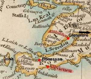
 Kilfinichen
and Kilviceuen including quad sacra parish of Iona Kilfinichen
and Kilviceuen including quad sacra parish of Iona
OSA
Vol.14, page 170
Page 173 Lochs and Rivers.—As the six rivers
in Brolass and Airdmeanach have no bridges they become
difficult or impossible to cross after heavy rain. The
incumbent has been held up by them for 24 hours several
times even though just miles from his house. There are
also rivulets that become impassable.
Page 188 “The destructive rage with which the
civil wars were carried on in the time of Charles the
First, and a famine and pestilence, in the time of King
William, almost depopulated the whole parish. In the reign
of the latter Prince, people were dying for want upon
the high road, and buried where they breathed their last,
as the few surviving relations had neither strength nor
means to carry them to the common burying places. Upon
the whole coast of Brolass, it is said, 2 families only
survived, and very many parts of the other districts were
waste. King William's days are still remembered with horror.“
 Page
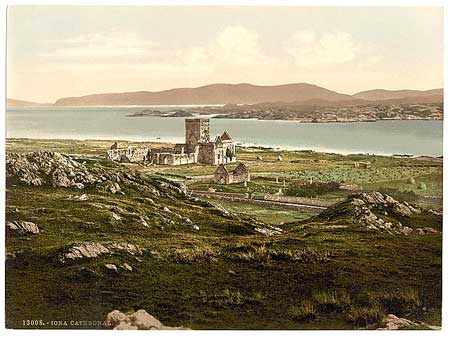
198 Details of Iona. Page
198 Details of Iona.
Page 203 (Iona) “To the N. of the abbey is a loch,
as it is called, but probably an artificial pond. It has
a paved causeway through the middle, which is still entire.”
In a footnote he says “The walk is called Iumaire
Iachair, which signifies a paved causeway.”
Many
watch-towers in the parish, said to be Danish.
Page 206 With no bridges, no roads other than the statute
labour roads in Ross, and no stage-houses, travelling
is tedious and sometimes dangerous.
The parish is very isolated not being on any shipping
route and there being only the pass through Glenmore (with
no road or bridge) to the rest of Mull.
Mention of “Bellach-na-co-sheilg, a pass near
the marches of Ross and Brolass, where the people of the
districts met at their hunting expeditions; from which
circumstance it look its name.”
Page 208 Post Office.—The nearest post-office
is in Aross which is 20 miles from the point of Ross.
A few get their post from Auchnacraig which is 24 miles
from the point. A runner had been employed to go to Aross
but no longer; now letters can lie there for a month.
NSA,
296
Page 306 Several “Danish/Norwegian” watch-towers.
Page 307 “…..a famine and pestilence during
the reign of William and Mary, almost depopulated the
whole parish. In King William's time, people died for
want upon the high road, and were buried where they
lay down,—their few surviving relatives having
neither strength nor means to carry the bodies to the
common burying places.”
 Page
310 Parochial Economy. Page
310 Parochial Economy.
Market-Town.—There is no market-town in the
parish.
Village.—There are 5 shop-keepers in the
village of Bonessan.
Means of Communication.—“Aros, in
the parish of Kilninian and Kilmore, is the head post-office
for this parish; but there is a sub-office at Bonessan,
and a receiving-house at Gribun, and regular foot-runners
convey the mail bags.” In the past people here
had to travel 20 miles or more to Aros.
“There
are no turnpike roads in this parish, or in Mull, nor
any Government roads, as in Skye and other parts of
the Highlands. Communication, however, is much facilitated
to and from the low country by steam-boats, especially
in summer and autumn, when clouds of tourists and visitors
come to view Staffa and Iona.”
Fairs.—Two fairs in Bonessan for black cattle.
Fuel.—Peat, and coal by those who can afford
it - it is generally brought from the Clyde.
Miscellaneous Observations. A notable change
from the time of the last account has been the introduction
of steam-boats that has opened a considerable trade
with Glasgow as well as making travel easier. There
are however a number of small boats that are inadequate
for the journey and it is quite common for goods to
be damaged or lost: it would be very useful if a regular
service by a larger sized packet or vessel could be
instituted.
Iona.
Very full details are given of the history of Iona.
See also Wikipedia
& 6" map Argyleshire
CIV
 Killarow
and Kilmeny Killarow
and Kilmeny
OSA
Vol.11, page 298
Page 299 Quay in Bowmore.
Page 300 Cattle—Two annual markets for black
cattle, attended by drovers from the mainland.
Page
302 Roads and Bridges—“The roads
in Islay are carried on to great perfection. Those already
finished are excellent, particularly from the Sound
of Islay to Bowmore, a distance of about 12 miles, wherein
there are 7 bridges, built with stone and lime. The
rest of the roads go on in course; and, in less than
20 years, they may be all travelled with carriages.”
NSA,
668
Island of Islay
Harbour and quay at Bowmore.
Page 669 Some details of Finlaggan, centre of the Lords
of the Isles.
Further
Information.
 Killean
and Kilchenzie Killean
and Kilchenzie
OSA
Vol.19, page 627
Page 627 “Its length, by the measurement of the
road, is 18 miles.”
Page
629 In a statistical table he notes that there was a ferryman
to Gigha.
Page 631 Advantages and Disadvantages.—“The
advantages of the parish are, a good road, its vicinity
to the sea, and to a market at Campbelltown, with abundance
of natural manure from sea-ware and lime-stone. Its greatest
disadvantages are, want of timber, and scarcity of fuel
in many farms, on which the peat-mosses are now exhausted.”
NSA,
376
Page 377 “The only high road in the parish is
that which leads from Tarbert to Campbeltown.”
Page 379 Reference to boats landing coals and uplifting
potatoes for the English and Irish markets.
“Typhous fever and other epidemic diseases are
becoming prevalent, which, it is believed, have been
introduced into the parish by Irish vagrants who are
conveyed by steam-boats to Campbelton, and itinerate
though the parish, begging their way from house to house.”
Page 380 “Peat and turf are the only fuel but
are scarce and at a great distance.”
Page 390 With no local market, produce has to be carted
20 miles or so to Campbelton.
Page 394 Fairs, Etc.—One small annual fair.
Three inns and 7 licensed alehouses.
1843
 Kilmadan Kilmadan
OSA
Vol.4, page 337
Page 341 “Peats are the common fuel, and for the
most part very ill to be got, on account of the height
of the hills, and bad access to them.”
“The statute labour is exacted in money. The bridges
are built and repaired by the statute money.”
NSA,
672
Page 674 “Several smacks … trade from the
mouth of the Ruel to the adjacent ports on the frith
of the Clyde in the export of potatoes (for which this
parish is famed,) and generally return laden with manure
for the farmers.”
No particular mention of roads.
1844
 Kilmartin Kilmartin
OSA
Vol. 8, page 90
Page 93 He gives details of the plan for a canal between
Loch Gilp and Crinan and the advantages that would result
from this, namely avoiding the Mull of Kintyre, improving
communication between the Western Isles and the mainland,
and giving easier access to coal and salt. If successful,
there is even the possibility of linking to Loch Awe which
would open up a large tract of country.
Page 98 Mention of a ferryman.
Page 102 There is a weekly packet from Loch Gilp to Greenock.
Page 105 Village, Fuel, Etc.—“Kilmartin
has a commodious inn, situated upon the great road from
the south end of Kintyre, by Tarbert and Lochgilp, and
leading to Fort William, by Craignish and Lorn. It has
3 markets in the year, 1 for black cattle, and 2 for horses,
where the country people gather from 15 to 20 miles round,
with webs of linen and woollen clothes, and such small
parcels of lint, as can be spared from their families.”
Peats are used as fuel though they are easily damaged
by rain.
Page
109 “The wages of a common day labourer, at husbandry,
road making, or any other work in that way, is from 1
s. to 14 d.”
 NSA,
547 NSA,
547
The high road from Lochgilphead to Oban passes through
here.
Mention of Ford of Lochawe.
Page 564 Parochial Economy. Two markets
are held at Kilmartin and two at the Ford.
The post is brought from Lochgilphead by a private runner.
There are daily steam-boat services between Lochgilphead
and Glasgow.
The road between Lochgilphead and Kilmartin is very good;
much money has been spent to improve it in recent years.
Page 566 Inn at Kilmartin and two change-houses at the
Ford.
Turf is available at the moss of Crinan though coal is
used by those who can afford them.
 Kilmore
and Kilbride Kilmore
and Kilbride
OSA
Vol.11, page 121
Page 123 Carts have now been used for some 12 or 14 years.
Manures used here are dung, sea ware and shell sand brought
in from the coastal areas of Ross and Inverness. The use
of lime is limited by the high price of coal for burning
the local limestone and the peats being so easily damaged
in a wet climate.
Page 124 Reference to supposed Danish watch-towers on
the coast.
 Page 125 Harbours and Ferries, Etc.—Four harbours,
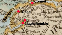
namely: “Oban, Dunstaffnage Bay, Ardintraive,
opposite to Oban, in the island of Kerera, and the Horse
Shoe Harbour, a little to the westward of Ardintraive
in the same island. There are 3 ferries, viz. Conil Ferry,
between this parish and that of Ardchattan; Fort Kerera,
between the main land and that island; and the Mull Ferry,
between the latter and the Island of Mull.”
Page 125 Harbours and Ferries, Etc.—Four harbours,
namely: “Oban, Dunstaffnage Bay, Ardintraive,
opposite to Oban, in the island of Kerera, and the Horse
Shoe Harbour, a little to the westward of Ardintraive
in the same island. There are 3 ferries, viz. Conil Ferry,
between this parish and that of Ardchattan; Fort Kerera,
between the main land and that island; and the Mull Ferry,
between the latter and the Island of Mull.”
The ferry at Conil looks very dangerous but the skill
of the boatmen allows them to cross over safely.
 Page
127 Roads, Bridges, Etc.—“There
is one great line of road finished, from Conil Ferry
to the extremity of the parish, on the S., about 6 miles
in length; another from Oban to Kilmore Kirk, across
the middle of the parish eastwards about 4 miles in
length; and a third from Oban to Conil, running also
eastward. It is now the common road for carriages, etc.
from Oban to Inveraray.” Page
127 Roads, Bridges, Etc.—“There
is one great line of road finished, from Conil Ferry
to the extremity of the parish, on the S., about 6 miles
in length; another from Oban to Kilmore Kirk, across
the middle of the parish eastwards about 4 miles in
length; and a third from Oban to Conil, running also
eastward. It is now the common road for carriages, etc.
from Oban to Inveraray.”
Bridges have been made where needed. These roads have
all been made in the last 33 years.
“There are 4 principal inns, viz. at Oban, Conil,
Claghchombie, and Kilmore, nigh the kirk, besides several
smaller ones.” He notes that “Claghchombie
inn is situated where the roads from Oban to Inverary,
and from Conil to Nether Lorn-cross, meet. It is not
far from Kilmore, and was on the common carriage road
to Oban, till of late, that the lower one was finished.”
Page 132 Details of Oban.
NSA,
522
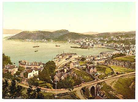 Mention
of Connell ferry. Mention
of Connell ferry.
Page 529 Parochial Economy. Markets.—
There are four markets held in Oban for black cattle
and for horses. There are also four small fairs in Kilmore.
Harbours.—Frequent steamers from Glasgow,
Inverness, Iona, Staffa, and Skye call in at Oban in
summer. There is also a daily coach in summer running
to Inverary.
Post-Office.—Post office in Oban.
Inns.—Outwith Oban there are 4 inns; in
Oban itself there is a principal hotel and a number
of public houses.
Fuel.— The fuels used are coal from Glasgow
and Ayrshire, and peat.
 Kilninian
and Kilmore Kilninian
and Kilmore
OSA
Vol.14, page 139 (Kilninian only for OSA)
Page 142 Roads and Bridges, Etc—The roads
here are very bad and improving very slowly. While partly
due to the proprietors not giving enough attention to
this, the main problem is the terrain and there not being
sufficient funds to overcome natural obstacles.
There is only one bridge in the parish and after rain
many of the torrents can make the roads impassable. At
present another bridge is being built at Tobermory.
Page 144 Harbours, Boats, and Ferries—He lists
the various harbours in the district, the main one of
which is at Tobermory, a village built by the “British
Society for improving the coasts.” Three or four
boats belonging to the parish sail along the coast with
freight.
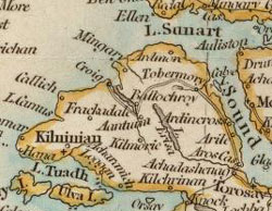 For
a few years, one or two packet-boats have sailed between
Greenock and Tobermory with calls at intervening harbours.
However, as they are conducting private business which
varies, they cannot be depended on by the public. Another
packet goes to Coll once a week. For
a few years, one or two packet-boats have sailed between
Greenock and Tobermory with calls at intervening harbours.
However, as they are conducting private business which
varies, they cannot be depended on by the public. Another
packet goes to Coll once a week.
There are 2 ferries to Morven, 1 to Ardnamurchan, and
1 to the parish of Kilfinichen. Occasional vessels go
to Tiree and other islands.
Page 145 Post Offices, Sheriff Court.—Post
offices at Aros and Tobermory with three deliveries a
week.
Page 147 Tobermory with its fine harbour has easy communication
by water with the fishing lochs to the north and the Clyde,
Liverpool etc on the south. The potential for improvements
is limited because of the coal tax and having to use peat
or turf as fuel which takes a great deal of time to obtain
and is often damaged by bad weather. The ground also is
very barren and it would need much attention from the
Society which founded the town to overcome these disadvantages.
Page
152 Exports and Imports.—Exports are kelp,
black cattle, sheep and wool and imports are oatmeal,
seed-corn, seed-potatoes, leather, salt and merchant
goods. Each of the parishes on the island holds a fair
for the black cattle, all within days of each other.
NSA,
339
Parish of Kilninian and Kilmore
Page 340 Lack of roads.
Page 345 Parish of Ulva
Page 349 There are remains of a pier or causeway, that
lead from the ruins of Glackingdaline castle to Ulva.
Page 352 “To make up for the short time steam-boats
give travellers, an opportunity is afforded them of
remaining behind, and, after having at leisure examined
the island, they may proceed in the evening to the Ulva
inn in any of the Gometra or Ulva boats, which at all
times attend the steamers; and next day they may either
return to Staffa and again embark, or proceed by land
to Tobermory, passing by the cataract of Esse-forse
before noticed; or, varying the route, they may proceed
by land or water up Loch-nan-gaul coast towards the
village of Salen, where the steam-boats touch.”
Page 354 Parish of Tobermory
Details of the town and harbour.
Page 357 Part of the parish of Salen
Mention of a bridge over the Salen on the new road to
Knock.
Page 358 United Parish (i.e. of above 4)
The roads are in a very bad state as the funds are totally
inadequate for such a large area. Although the proprietors
do what they can, the task is beyond any means but government
help.
Steam navigation has been of great assistance in opening
up communication with the low country but if roads and
bridges could be made with government help, this would
help to encourage new initiatives with an input of capital
from the low country and result in a great improvement
to this area.
 Kilninver
and Kilmelford Kilninver
and Kilmelford
OSA
Vol.10, page 315
Page 316 “The Sound of Clachansoail is about two
miles long, and separates the Island of Soail and parish
of Kilbrandan from the Continent. The Sound is narrow,
being no more than 80 feet over, and admits vessels of
only between 10 and 20 tons burden, as it is dry and passable
at low water, in some parts, both for men and horses.
It runs smooth and straight, with a strong current, and
forms a beautiful canal. Formerly there was a ferry boat
here, but lately there has been a bridge built over it,
consisting of a single arch, 72 feet wide, and 27 feet
above the highest water mark.”
Page 325 Among the disadvantages are the great distance
from markets and having to obtain peat at much trouble
and expense. Tenants may also owe their landlords the
personal service of obtaining peats for the landlord as
well as themselves. The removal of the coal duty would
alleviate this somewhat.
NSA,
61
 |
| The
old road from Kilninver to Loch Awe. Based on quarter-inch
OS map 1923 |
Page
62 “The sound of Clachan above-mentioned, which
forms the western boundary of Kilninver, is about two
miles long, and averages about eighty feet broad. It
runs smooth and straight, with a strong current, and
forms a beautiful canal. Though it is passable at some
places at low water, and a regular ferry always available,
yet the inconvenience was generally felt and complained
of. A bridge at length was built, consisting of a single
arch, 72 feet wide and 27 feet above the highest water-mark,
and admits vessels of about twenty tons burden.”
Page 65 Mention of spectacular scenery on the road from
Lochgilphead to Oban with “rocks on both sides
several hundred feet high, and in many places overhanging
the road.”
Page 68 Antiquities. - “Cairn Challein,
or Colin's cairn, is erected on a conspicuous spot,
on the old line of road, between Kilninver and Lochawe….”
Note: the mention of the cairn makes
it likely that this road went much along the line of
the present road for about two miles SE of Kilninver
to the Euchan and then followed the Euchan to Loch Scamadale.
From here a track goes down to the cairn and Loch Avich
from where Loch Awe would be easily reached, perhaps
near Dalavich with a ferry on the opposite shore at
Portinnisherrich, or following the north side of the
loch up to Kilchrennan where there was another ferry
on a route that led to Inverary.This road coincides
with part of the route recorded on the Heritage Path
site as String
of Lorn (Sreang Latharnach) that had been in use
variously as a pilgrimage route to Iona, a drove road,
and a coffin road to Kilmore church.
Page 70 Parochial Economy.
The nearest market-town is Oban, about eight miles from
Kilninver.
Fifteen miles of public road in the parish.
Fair.—Two hiring fairs.
Inns, Etc—Two inns and 2 public houses.
Fuel.—Coal and peat.
1843
Note: The building of the Bridge at
Clachan Seil - a Brief History by George Doyle 1992
gives full details of the bridge. It is popularly known
as the "Bridge over the Atlantic". See also
a Secret
Scotland article on the bridge - this has interesting
information about other bridges and causeways in the
west of Scotland.
 Knapdale,
North Knapdale,
North
OSA
Vol.6, page 255
Page 256 Mention of numerous watch-towers along 150 miles
of coast.
No particular mention of roads although cattle are sent
to market.
NSA,
631
Page 636 Forts.—He refers to fortifications
that might have been watch-towers, and to a Dun a
bheallich, or the fort of the pass which may have
guarded the pass between the bay of Carsaig and the
bay of Tayvallich.
“Castle Sween commanded the entrance to Lochswen,
and was regarded as the key of the districts of Knapdale
and Glassary, and as such it was deemed a position of
the greatest importance."
Page 640 Navigation.—Five vessels trade
from here to Greenock, Liverpool, and the coast of Ireland.
Parochial Economy.
Market-Town.—The nearest market town is Lochgilphead.
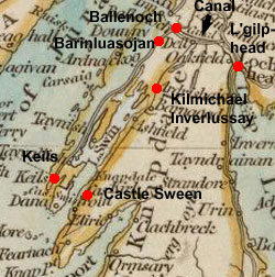 Means
of Communication.—Bellanoch is a sub-office
to Lochgilphead, with three deliveries a week. Means
of Communication.—Bellanoch is a sub-office
to Lochgilphead, with three deliveries a week.
“The road between Lochgilphead and Keills, where
there is a ferry to the Island of Jura, passes for fifteen
miles through the parish, sending off a branch at the
farm of Barinluasojan to the church of Kilmichael Inverlussay.
There is a new line of road in progress from Inverlussay
to Castle Swen, which, when completed, will be of essential
benefit to the whole of the east side of the parish,
and to the district of Knap in the parish of South Knapdale.”
Steam-boats sail daily between Glasgow and Inverness,
through the Crinan Canal.
Page 643 Inns and Alehouses.—Six.
Fuel.—The main fuel is peat, expensively
worked in mosses 2 or 3 miles away. Some wood is also
used and coals by those who can afford them.
Miscellaneous Observations. Considerable benefits
from 20 miles or more of public roads having been made,
and the opening of the Crinan Canal.
1844.
 Knapdale,
South Knapdale,
South
OSA
Vol.19, page 308
Page 309 Mention of road between Inverlussay and Glassary.
Page 320 Roads.—“The roads are extremely
bad, especially in winter. The best is a part of the great
road on the east side of the parish, which leads from
Inverary to Campbelton. It was made by the spirited exertions
of the Duke of Argyle, assisted by the gentlemen of the
county. In some places it is formed on the sea-shore,
through a ridge of rugged rocks, 34 feet at least perpendicular
above the sea.”
Nine
publicans are mentioned in a list of occupations.
Page 326 Disadvantages. Among these are the bad
roads, the distance from market-towns, and the time
taken to gather peats and the danger of losing them
in a wet season.
NSA,
257
Page 259 The many streams and rivers here are fordable
in summer but the larger ones are not fordable in winter.
However, those on the line of the main roads are bridged.
Page 262 Antiquities. There used to be 7 ancient
chapels here.
He refers to an incident in 1643 involving an old cottage
at “Stronchullin on the coast of Lochfine, and
not far from the church of Inverneill“, which lay
at the foot of a hill over which the road to Tarbert
went
Page 265 Parochial Economy. Details of the Crinan
canal.
Page 270 More than 20,000 steam-boat passengers now
pass through the canal each year, as well as many cattle,
sheep and lambs. There is now a passage-boat on the
canal which makes the journey from Greenock to Oban
and Inverness much quicker.
 Page
273 Roads.—There is a very good road from
Daill in the north-east of the parish to Barnellan in
the south. Where it leads for 10 or 12 miles on the
eastern edge of the hills that lie between Lochfine
and Lochcaolisport it is known as the Lliabh Gaoil. Page
273 Roads.—There is a very good road from
Daill in the north-east of the parish to Barnellan in
the south. Where it leads for 10 or 12 miles on the
eastern edge of the hills that lie between Lochfine
and Lochcaolisport it is known as the Lliabh Gaoil.
Before
this road was made Kintyre was quite isolated from the
rest of Argyleshire. “The only path by which
any communication between the two places could be maintained,
was almost quite impassable. It ran along hills and
dales, which were intersected by water courses without
any bridges. In summer, these waters were fordable,
but in winter the attempt to cross them was both difficult
and dangerous.”
Although
not as busy now because of steamships, it was and is
still very useful as the only road connecting Argyleshire
with Kintyre. It was made by Sheriff Campbell (d.1777)
whose perseverance saw it through to completion. An
English engineer had been employed to survey a route
but when “he attempted to travel over the ground;
the rocks were so precipitous, the ferns so gigantic,
the Englishman so unwieldy, and so unaccustomed to travel
such rough grounds, that, after much tumbling and scrambling,
he was obliged to betake himself to his boat, and finish
his survey by rowing along the shore.”
Market-Town.—
Those in the south of the parish use Tarbert to buy
necessities and to dispose of their produce whereas
those in the north use Lochgilphead.
Means of Communication.—There are regular
and cheap steam-boat services to Glasgow and ports on
the Clyde and to Oban, Fort William and Inverness as
well as Tobermory, Strontian, and Skye. Jura and Islay
can be reached from West Lochtarbert.
The mail comes from Inverary to Lochgilphead from where
it used to be taken by land to Tarbert. Now, however,
it is taken by steamer from Addressing (Ardrissaig)
to Tarbert missing out large stretches of the parish
to the great inconvenience of those living there.
Inns.—
“On the western side of this parish, along Lochcaolisport,
there is but one public-house, which is all that is
necessary. On the eastern side, at Ardrissaig, and that
part of the mission of Tarbert connected with this parish,
the number is much greater.”
Fuel—Mostly peat although coal from Glasgow
and Ardrossan is used on the east side of the parish.
 Lismore
and Appin Lismore
and Appin
OSA
Vol.1, page 482
Page 496 Hills.—A fine road now leads through
Glenco.
Page 490 He refers to the amount of time wasted in obtaining
and preparing peats and the difficulties arising from
the coal tax.
Page 491 “Lismore was a Bishop's See, the residence
of the Bishop of the Isles, and, at certain periods, of
the Bishop of Argyle.”
Page 493 Antiquities. Vestiges of Roman fortifications
on Lismore.
Near the cathedral there are remains of what was probably
a watch-tower, so common on the west coast.
Page 496 Services.—He refers to the difficulties
arising from tenants having to perform services for their
landlords. He says in passing that some work 2 or 3 days
on the roads.

Roads and Bridges.—“Since the residence
of the present incumbent in the parish, roads and bridges
have undergone a remarkable change for the better, especially
in Appin. There is an excellent line of road, mostly finished,
from Shian Ferry through Airds, Strath of Appin, Duror,
and Glenco, to the King's House at Lubnamart, with 6 or
7 bridges, for a course of 17 or 18 computed miles, besides
several by-roads. Last year a line of road has been opened
to Glencreren. There has been little done to the roads
in Lismore. There are no tolls in the Highlands.”
Post-Office.—A post-office is now established
in Appin removing the need for the former privately employed
runner to collect the mail from Inverary. Now there is
a runner three times a week to Bunaw and Inverary. Mail
is also taken from Bunaw to Oban and over to Aross on
Mull. Other branches go from Appin to Fort William and
to Strontian. A letter now takes about 3 days to come
from Edinburgh.
“Numbers of carriers are employed monthly between
Appin, Benderloch, Oban, and Glasgow and vessels called
packets run generally once a month between Greenock, Oban,
and Mull, with goods of various sorts for the accommodation
of the neighbouring countries.”
Page 498 Public Houses “In Kingerloch there
are 2 public houses, at the two ferries to Lismore and
Appin, where they cannot be wanted (are needed); in Appin
there are 9 or 10; in Lismore 7 or 8.”
Page 499 Sea Coasts and Currents. Mention of currents
at ferries at Bailichelish, leading up to Lochleven and
the slate quarry, between Lismore and Appin, and at Shian
Ferry, between Appin and Benderloch
Mines, Quarries, Etc.—Large slate quarry at
Bailichelish, from where slates are taken to Leith, Clyde,
England, Ireland, and even to America.
Lime burning has started in Linisore and Appin but the
coal tax restricts it somewhat.
Advantages and Disadvantages.—Good roads.
Peats are generally used but too much time is taken to
obtain them and they can be ruined by bad weather. The
coal duty is very much a hinderance to any progress and
the salt duty also causes difficulties. There is a lack
of public markets here.
NSA,
223
Page 225 Mention of the ferry of Shian and the Kings
House at the head of Glencoe.
Page 229 Mention of the Fingalian heroes hunting near
Lochoscar.
Page 223 Mention of droving.
Page 238 Reference to Ossian and the Fingalians
Page 248 Slate worked at Ballachulish is conveyed up
to 650 yards to the sea by tramway where it is loaded
onto boats.
Page 251 Parochial Economy.
Market-Town.— “The nearest market-town
to the parish is Oban, which is ten miles by land from
Appin, and seven miles by sea from Lismore. Here there
is a ready market, to a considerable extent, for every
kind of produce, and here also can every kind of supplies
be obtained; but since steam navigation has been established
on the western coast, the principal trade is with Glasgow
and the south.”
Means of Communication, Etc.— At the time
of the OSA the mail came three times a week from Inverary
to the then newly established post-office in Appin.
Now it is daily with a runner going to a penny post
at Lismore, and a runner from Strontian to the penny-post
in Kingerloch. Newspapers published in Glasgow reach
here the same day, and Lismore the next morning.
There
are regular steamers between Glasgow, Inverness, Mull
and Skye which afford fast and cheap transport for passengers
and produce.
“There
are no tolls in this parish. The roads are kept in excellent
order, particularly in Appin, by converted statute labour.
The roads in Lismore are not so good, and there are
scarcely any roads at all in Kingerloch, if we except
two or three miles, which the proprietor made near the
mansion house.”
Page
252 In describing the ecclesiastical administration
of the parish he refers to the considerable distances
that have to be travelled by two missionaries when covering
their assigned districts.
Page 255 Fairs.—There is a small fair in
Lismore to sell off any cattle that remain unbought
by the drovers who visit the island to buy for the southern
markets. There are also two fairs at Duror, in Appin;
and cattle markets there to allow drovers to pick up
additional stock as they make their way to the southern
markets
Inns.—“There is an excellent inn
at the ferry of Bailechelish, on the north; and there
are also inns at Shian ferry, on the south; at the ferry
of Port Appin; and at the ferry of Crigan, on Lochcreran.
A few miles north of these, is the inn at Portnacroish;
and still farther north, and within five miles of the
inn of Bailechelish, there is the Duror inn: and there
is also a small public-house at the farm of Clachaig,
in Glencoe, which is very useful to people passing through
the glen. These seem to be necessary, as the most of
them are at the ferries; but there are, besides these,
several other little dram-shops, which are by no means
necessary.”
Fuel.—He explains how uneconomic it is to have
to use peat. In Lismore they have to be tramped underfoot
then kneaded by hand to make the fibres stick together;
and as they are becoming scarce now have to be brought
by sea and land from Kingerloch and Benderloch in Ardchattan.
The peat in those places is easier to work and is near
at hand so is more economical.
Miscellaneous Observations. In arguing that Lismore
would make a good place to start some industry he refers
to Glasgow being 24 hours away by steamer, and Liverpool
2 days.
 Lochgoilhead
and Kilmorich Lochgoilhead
and Kilmorich
OSA
Vol.3, page 160
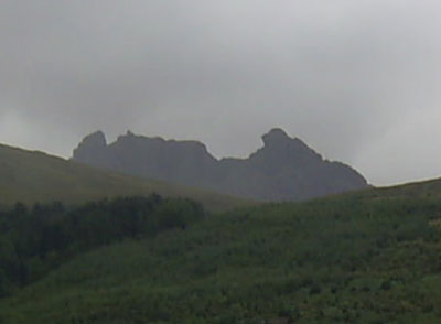 Page
164 Although limestone is available locally it cannot
be fully exploited because of the bad roads and the
difficult communications with the various parts of the
parish. Some limestone is brought in from Ireland. Page
164 Although limestone is available locally it cannot
be fully exploited because of the bad roads and the
difficult communications with the various parts of the
parish. Some limestone is brought in from Ireland.
Page 173 Fish. Herring caught in Loch-long and
Loch-goil can be taken to Greenock or Glasgow by boat,
wheras those caught in Loch-fine have to be taken in
creels on horse-back to the head of Loch-goil, some
8 or 10 miles. This is an additional expense and the
fish can be damaged on the journey.
Page 177 Cattle is sold to the butchers of Glasgow,
Paisley, Greenock, and Dumbarton.
Page 188 Inns.—There is an inn at Lochgoil-head
on a well-frequented pass between the West Highland
and the Low Country, and another at Cairndow on the
great western military road, and “the only stage
between Arrochar and Inveraray.” There are also
some huts where spirits are sometimes sold.
Roads and Bridges.—“The roads were
formerly made and kept in repair by the statute labour;
but that method was found inconvenient, and ineffectual,
for making and keeping up good roads.
Some years ago, an act of Parliament was obtained for
the county of Argyle, converting the statute labour
into money, to be paid at the rate of 2 s. by every
male person above 14 years of age. There is also an
assessment upon the land, at the rate of 1 s. per pound
of valued rent, a third of which is payable by the proprietors,
and two-thirds by the tenants."
 |
|
Stone
at the summit of the Rest & Be Thankful. It
reads: Military
Road repaired by 93rd Regiment 1768. Transferred
to Commissioners for H.R.&B. in the year 1814
|
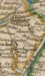 "The
great military road from Dumbarton, to the West and
North-west Highlands, goes through 16 miles of the upper
end of this parish; but, upon the west coast of Loch-long,
and upon both sides of Loch-goil, there is scarce so
much as a path; the ruggedness of the country renders
travelling extremely difficult, and the many large and
rapid waters without bridges, make these parts of the
parish often impassable. "The
great military road from Dumbarton, to the West and
North-west Highlands, goes through 16 miles of the upper
end of this parish; but, upon the west coast of Loch-long,
and upon both sides of Loch-goil, there is scarce so
much as a path; the ruggedness of the country renders
travelling extremely difficult, and the many large and
rapid waters without bridges, make these parts of the
parish often impassable.
It is found very difficult to keep up the bridges in
many parts of the country; the rivers swell so suddenly,
and rush down from the mountains with such rapidity,
that the bridges must be built in very advantageous
situations, in order to stand any time. There is one
bridge in particular, near Lochgoil-head, which has
fallen three times, within the last 15 years; it was
built at first, and twice rebuilt, at the expense of
the inhabitants.”
Page 190 Advantages and Disadvantages—Those
living near Loch-fine suffer from scarcity of peat which
they have to obtain from the mountain summits. They
also suffer from difficult communications with the Low
Country, and the high price of coal to which is added
the coal duty.
Page
192 The other parts of the parish however have an easy
access to markets by the military road and by sea with
Greenock, Dumbarton, Glasgow etc being easily reached.
NSA,
701
Page 706 Parochial Economy.
Lochgoilhead is now a main route to Inverary where a
steamer from Glasgow calls every day and the journey
continued for 8 miles by stagecoach.
1844
Addendum
Miscellaneous
Observations
Since the last Account a major change has been the introduction
of steam navigation. Instead of black-cattle and sheep
having to be driven a long and debilitating distance
they now arrive in Glasgow and Greenock in a few hours.
Herring no longer have to be taken on horseback to Lochgoilhead,
and now reach the market on the same day they were caught.
They even reach Liverpool the day after they were caught
and are sent onward by rail to Manchester and other
towns. People journeying to the mainland no longer have
to climb the Duke of Argyle's bowling green, or sail
across sometimes dangerous waters and often in bad weather.
1845
 Morvern Morvern
For
further information on Morvern including details of
roads, see Morvern
transformed: a Highland parish in the nineteenth century
By Philip Gaskell
OSA
Vol.10, page 262
Page 266 “The exports are, cows, horses, sheep,
wool, kelp, timber, and barks. The imports consist of
many articles; the principal of which are, meal yearly
in great quantities, tanned leather, iron, tar, ropes,
smearing butter, merchant goods of various kinds, &c.”
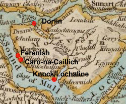 Page
267 Roads, Rivers, Etc.—There is a line
of road along the coast made by the statute labour which
can be ridden but any other roads are in a state of
nature. The people are starting to realise the advantages
of good roads but being scattered and there being a
want of heritors to push them forward, progress is very
slow. Page
267 Roads, Rivers, Etc.—There is a line
of road along the coast made by the statute labour which
can be ridden but any other roads are in a state of
nature. The people are starting to realise the advantages
of good roads but being scattered and there being a
want of heritors to push them forward, progress is very
slow.
There are many torrents that are dangerous in flood;
only three are bridged and one of these is in a very
unsafe condition.
Wood from this locality is sold to the Lorn-furnace
company for charcoal.
Page
269 Ferries, Etc.— There is a stated ferry
to the Mull from Ferenish and another from Dorlin at
the mouth of Loch Suineart over to Ardnamurchan. One
is needed in the east of the parish, either at Kyle
or Knock “where, though the boatmen ferry at
times, one cannot force them out but when it suits their
humour and conveniency, and even then at whatever rates
they please to exact.”
Page 275 Miscellaneous Observations. —With
peat so difficult and time-consuming to obtain it would
be a great benefit if coal could be brought here by
sea.
There
is a need for a more regular communication by water
to the low country. There is a vessel comes from the
Clyde but it is used for private business which takes
precedence over public convenience.
NSA,
163
Page 169 Folklore tells of a particular rock formation
being the remains of a bridge which a lady of great
physical strength had started to build between Morvern
and Mull.
Note: Carn-na-Caillich - see map.
Page 174 In talking about the domestication of wild
animals he refers to “an old respectable person,
who had some years ago rented the ferry and small inn
of Lochalin, and succeeded wonderfully in training a
magpie, which repaid the expenses of her education,
by not infrequently subjecting her preceptor to the
very unnecessary trouble of paddling to the opposite
shore, where, in place of the expected passenger, he
found his docile pupil perched upon a rock, chuckling
with hearty mirth at the success of her imitations.”
Note: This must refer to the short
crossing from Lochaline village across the mouth of
Loch Aline rather than over to Mull - see 6" map
Argyleshire sheet
LXX.
Page
189 Parochial Economy. Market-Town.—Tobermory
and Oban although since the village of Lochalin has
been formed some people are now going there.
Means
of Communication.—This is much improved since
steam-navigation started with a service in 1821 from
Glasgow to Lochalin and Tobermory. There are 3 ferries
on the Sound of Mull, and two on Loch Suinart. In winter
when the service to Tobermory can be interrupted there
is a packet-boat between Oban and Lochalin.
Post-Office.—There
is a sub-office to Oban here but due to the lack of
roads in this parish that make Oban near impossible
to reach by land the mail has to cross two islands and
three ferries.
There
is a road of sorts along the Sound of Mull but a cart
can only be driven on it for 5 continuous miles. There
are no roads in the interior. The Government grant which
had a stipulation attached to it was not accepted so
that “the county line, as it is termed, does not
extend to or embrace this parish.” Various possible
lines of roads have been surveyed. However, the main
rivers have been bridged, though further work needs
to be done.
He
refers to several safe anchorages along the coast and
says that a pier at Lochalin had been constructed.
Page 194 Fairs.—“A fair is held
in the parish twice a-year, on the days preceding the
Mull summer and winter markets, for the sale of black-cattle,
and the hiring of servants, and the transaction of district
business.”
Ale-houses.—Three public-houses, and three
places where spirits are sold.
Fuel.—Turf, peat, and coal by some. The
first two takes much time and expense to gather.
Muckairn
OSA - see Ardchattan and Muckairn
NSA,
508
Page 519 Details of the smelting works at Bonawe (further
information).
Page 520 Vessels come from Ulverstone with iron ore and
return with iron bars once it has been smelted.
Parochial Economy. Market-Town,—Oban, which
is 12 miles from the church.
Means of Communication.—The Oban to Inverary
road passes through for 8 miles but there are no other
proper roads. A coach runs on this road. There is a post-office
at Bonaw.
Inns.—Two.
1844.
 Saddell
and Skipness Saddell
and Skipness
OSA
Vol.12, page 475
Page 478 Roads.—There is a road from Inverary
to Campbeltown and the south end of Kintyre where there
is a ferry over to Ireland. There is another line of road
on the west side of Kintyre.
The roads are very good and well maintained: they were
made partly by statute labour and partly by voluntary
subscription. In order to complete them an act of parliament
was obtained that allowed a stent to be imposed. The exertions
of the gentlemen have to be noted in these improvements,
not just in their own district but elsewhere in the county,
particularly the major undertaking at Sha’-goil.
 Rivers
and Bridges. A number of rivers here still need
to be bridged but with no funds available, there is
a need for public aid. This lack of bridges has serious
effects “particularly in the case of the post,
surgeons called to the sick, the minister of the parish,
and the parishioners in getting to and from the church,
and in travelling about their affairs, marriages, christenings,
burials, markets, mills, smithies etc.” The
commissioners of supply and surveyors of roads have
put large planks across them for foot-passengers but
horses cannot cross when the streams are in flood. Rivers
and Bridges. A number of rivers here still need
to be bridged but with no funds available, there is
a need for public aid. This lack of bridges has serious
effects “particularly in the case of the post,
surgeons called to the sick, the minister of the parish,
and the parishioners in getting to and from the church,
and in travelling about their affairs, marriages, christenings,
burials, markets, mills, smithies etc.” The
commissioners of supply and surveyors of roads have
put large planks across them for foot-passengers but
horses cannot cross when the streams are in flood.
Page 480 Details of the Herring Fishery
Page 483 Now that the duty on coal taken coastwise has
been removed, coal can be used instead of peats which
were difficult and expensive to obtain from the hills
and in danger of being unusable in wet weather. The
time saved can also be used to carry limestone in for
manure.
Page 484 Details of the abbey of Saddell.
Page 487 Many beggars from Ireland and various parts
of Scotland.
NSA, 436
Page 455 Details of Cistercian monastery at Saddell.
He notes that “after it had for centuries withstood
the violence of the solstitial rains and equinoctial
gales the hands of a modern Goth converted it into a
quarry, out of which he took materials to build dikes
and offices,—paving some of the latter with the
very grave-stones.”
Page 450 Smuggling was once prevalent.
No particular mention of roads.
 Southend Southend
OSA
Vol.3, page 363
Situation, Extent. - Southend is about 7 leagues
from Ballycastle but little trade is carried out with
Ireland. There is a ferry which the Irish use to bring
in some black cattle and return with small horses.
Surface,
Etc.—
Forty years ago there were no carts here and very little
lime used. Although it is now used, this is limited
by the tax on coal,which is needed for burning limestone..
Produce.—Barley, meal, and potatoes, are
sold in Campbeltown.
 NSA,
413 NSA,
413
Page 430 In a description of the lighthouse at the Mull
of Kintyre he says that the “light-room and
the reflecting apparatus were brought from Edinburgh,
and carried chiefly upon men's shoulders over the mountains.”
The lighthouse was completed in 1788. In 1828 a new
road was made through the Mull to the lighthouse.
Page 433 Parochial Economy. It is 9 miles to
Campbelton, the nearest market and post-town. There
are no turnpike roads here but the roads and bridges
are good thanks to the efforts of the main heritor.
Page 435 Inns.—One inn and 4 other establishments.
Fuel—Peat is obtained at the expense of
much time and labour. Inferior coal is available in
the parish of Campbeltown, but is 10 or 12 miles away.
Miscellaneous Observations. Building a pier or
quay at Dunaverty bay would allow the parish to obtain
better prices for their produce on the Clyde and elsewhere
than in Campbeltown, as well as ensuring a direct supply
of coal from Ayr, the Troon, and Ballycastle in Ireland.
1843.
 Strachur
and Stralachlan Strachur
and Stralachlan
 |
| Strachur
church. This is the old road that runs through the
village. The village has now been by-passed by a
more modern road. |
OSA
Vol.4, page 555
Page 560 Possible alarm-tower on the summit of Sien-Sluai
(Sith an t’Slunin, 4 miles SSW of Strachur).
Page 563 Charcoal is made here and used at the furnace
set up on the other side of Loch Fyne; it is also sent
to England (further
details).
Page
564 Two ferrymen and two innkeepers.
Page 567 A road is currently being made on the south
side of Lochfine.
Page 568 Road on north side of Lochfine
Page 573 Disadvantages.—Peat is used but
is both difficult and expensive to obtain. Removing
the coal tax would improve matters and also allow greater
use of lime if coal was used to burn the locally available
limestone. The nearby parishes of Lochgoilhead and Dunoon,
being on the Clyde do not have to pay this tax.
Advantages.—Being near the Clyde, butchers
from Greenock and Glasgow come directly here to buy
cattle, as for the whole of Cowal. Greenock is easily
accessed by the farmers where they can sell their produce
and purchase anything they need.
 NSA,
103 NSA,
103
Page 106 Navigation.—Wool and potatoes are
sometimes collected by boat at Strachur Bay.
Parochial Economy. Means of Communication.—
Steamers run between Glasgow and Inverary.
“The Government road to Ardentinny affords daily
intercourse, through the Lochgoil steamer, with the
towns upon the Clyde; and the coach establishment between
St Cathrine's and Lochgoilhead affords the opportunity
of comfortable and speedy conveyance.”
Fairs.—Two are held in Strachur for black
cattle.
Inns.—Three.
1843.
 Tiree
and Coll Tiree
and Coll
OSA
Vol.10, page 393
Parish of Tiry (includes Coll)
Page 398 Although the Duke of Argyle gives his tenants
free timber from his woods of Lochsunart, it is 60 or
70 miles away and requires a long and expensive journey.
Page
399 He describes a plain near the centre of the island,
called the Reef. On one side it is bounded by Faothail,
a small channel, that in heavy rain and high spring tides
is difficult or impossible to cross as there is no bridge.
There is some danger of the island being cut in two and
a barrier has been erected to prevent this.
Page
401 Antiquities. Remains of watch towers on the
coast which are visible from each other.
Page 405 Fuel.—Coll has plenty of peat but
some of the farms are quite distant from it so that
they would find coal cheaper. Tiree has some peat left
at one end but very little at the other end so that
the people there sometimes have to use horse dung, straw,
or even “burning the roofs of their houses or some
of their furniture.”
Page 412 Agriculture, &c.—“After
a little amendment of the roads, with the money that
is raised, or the services that may be exacted, there
is no country better calculated for them.”
Sea-ware carried in creels on horseback from the shore.
Page 414 “A country man, who died last year
about five feet 10 inches high, was employed by the
laird of Coll as post to Glasgow or Edinburgh. His ordinary
burden thence to Coll was 16 stone. Being once stopt
at a toll near Dumbarton, he humorously asked whether
he should pay for a burden, and upon being answered
in the negative, carried his horse in his arms past
the toll.”
Page
416 Ferries.—There is a stated ferry between
Tiree and Coll which is often dangerous because of heavy
seas and currents. Also dangerous is the stated ferry
between Coll and Mull, which crosses 8 or 12 miles of
sea to the landing places on Mull. There is no stated
ferry from Tiree to Mull. A packet to Mull is much needed,
and it could be that when the Crinan canal is opened
some will find it in their interest to keep a packet
in view of the growth in trade in coal, marble, fish,
potatoes etc that will result.
Page 417 Advantages and Disadvantages.—Among
measures that are needed are a ready access to salt,
improved harbours, removal of the tax on coal (now removed),
markets, and improved communication with towns.
NSA,
195
Page 196 Tiree. Topographical Appearances.—In
the middle of the island there is a low-lying area called
Reef that was probably once covered by the sea. On its
east side there is an inlet “called the ford, or
in Gaelic "foadhail."“ A stream runs
into this inlet and forms the boundary between the east
and west sides of the island. As spring-tides often
make it impossible to cross at the ford, a small bridge
has been built half a mile inland.
Page
202 At Bailephetrish a marble quarry was worked between
1791 and 1794. Heavy blocks were taken by boat round
to the harbour, lighter ones overland. Transport proved
uneconomical however and the quarry was closed.
Page
205 There are 14 or 15 duns or old forts which are thought
to be Danish and were used as watch-towers. They are
generally near the coast and are circular.
Page
217 Parochial Economy.
The nearest market town is Oban but it is 56 miles distant.
There is a small village in Coll, Arinangour.
Means
of Communication.—Tiree and Coll have post-offices
served from Tobermory but with no packet, deliveries
are very irregular.
The harbours, which are important to islands, are indifferent.
On Tiree, Scarinish is the most used for the shipping
of cattle and produce. There is another at Accarsaid
and a pier has recently been built at Heinish. Coll
has a harbour at Arinagour.
As
to roads we are fortunate to have some fine beaches
on which horses and carts can easily travel, as some
of the roads are extremely bad, including the important
one between the harbour and the mill which can be sometimes
be impassable in winter. The road making could only
progress if it was supervised properly.
There are three markets on both islands for black cattle.
Inns, Etc.—Two inns on Tiree and one in
Coll, with some tippling houses, one or two of which
are near the Light-house work.
Fuel.— As peat is nearly exhausted on Tiree
it has to be brought from Mull or Coll at great expense.
Coll is better provided with peat.
1840/1843
 Torosay Torosay
OSA
Vol.3, page 265
Page 265 The name may derive from the Gaelic and mean
“a mound or small hill, and ford, or a pass over
water.”
“The length of the parish from north to south
is computed at about 12 miles by the shortest road; but
along the coast the road forms a curve, and is much longer…”
Page
267 Miscellaneous Observations. Wood for charcoal
is sometimes sold to the Lorn Furnace Company.
 There
are ferries to Morven, Lismore, Nether Lorn and the
main one in Mull from Achanacraig in Torosay to Kerrera,
and then to Oban. At this ferry some 2000 black cattle
as well as many horses are carried over to the mainland.
This number includes cattle from Coll and Tiree which
are driven across Mull. Cattle from this parish and
Kilninian are also ferried to Morven. There is an annual
market for horses held in Torosay. There
are ferries to Morven, Lismore, Nether Lorn and the
main one in Mull from Achanacraig in Torosay to Kerrera,
and then to Oban. At this ferry some 2000 black cattle
as well as many horses are carried over to the mainland.
This number includes cattle from Coll and Tiree which
are driven across Mull. Cattle from this parish and
Kilninian are also ferried to Morven. There is an annual
market for horses held in Torosay.
From
Achanacraig ferry, a road has recently been made to
Aross in Kilninian parish, 20 miles distant. It has
5 bridges. There is also a bridge over the water of
Ba.
NSA,
277
Page 278 Glenmore had no road until recently, despite
being the main route for those living in Kilfinichen
travelling to the rest of the country. A road, recently
made at the expense of the proprietors and the county,
runs through Glenmore up to the main road between Tobermory
and Auchenacraig ferry. Those living in Kilfinichen
parish now find it much easier to reach Torosay where
the main fairs of Mull are held, and the ferry. This
road may soon be extended to the Sound of Iona which
may well suit many visitors to Iona rather than undergo
a rough sea-voyage. It will also allow the island to
be visited all year round as steamers can only make
the journey in summer.
Page
292 Parochial Economy. The nearest market town
is Oban, 10 miles away on the mainland.
Means
of Communication.—There is a post-office at
Auchenacriag with three deliveries weekly. There is
a road from the ferry to Tobermory and the road to Kilfinichen;
the bridges are good. In summer steamboats run nearly
every day along the south coast landing goods and passengers
as necessary. There are ferries to Morven, Nether Lorn,
and Kerrera, this being the main way of reaching the
mainland. Coll and Tiree cattle are still landed at
the back of Mull and driven here for the journey to
the mainland but many are now taken directly to the
mainland.
Page 295 Fairs.—Three fairs are held on
the farm of Fishnish, 11 miles from Auchenacraig Ferry.
Inns.—Four.
Fuel.—Mainly peat. Coal has been available
from vessels passing through the Sound of Mull, but
the price has now gone up.
Miscellaneous Observations. At the time of the
last Statistical Account there were no carts; now all
crofts have them.
Top
|