|
Coupar
Angus Charters
Overview
 |
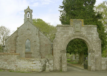
| The gatehouse is
all that remains of this once important abbey. It
was founded about 1160. |
The roads and bridges referred
to below are those mentioned in records of Coupar Angus
Abbey. Other records will be examined in due course.
While the Coupar records are useful
for determining both local routes and routes in Perthshire
and Forfarshire, they have to be seen against an assumed
network of strategic routes that are not necessarily
mentioned in these records.
Among these we know from other
sources that there was a route north from the Forth
through Fife and over the Ochils to the Bridge of Earn
and Perth, as well as one from Stirling north to Perth.
From Perth there was a route to
Dunkeld and Blair Athol and then northwards by the Comyn's
road to Ruthven and beyond. A route ran east from Perth
to Dundee then by the coast to Montrose and the north.
Another route to the north went by Brechin to Aberdeen.
Of the abbey itself Franklin explains
how after meeting the five requirements of establishing
an abbey (land, building materials, fuel, water and
food) through various grants, it started to utilise
these lands, partly by the monks but mostly by the use
of conversi or lay brothers. The very rapid progress
led to a "golden age" where land was drained
and crop yield vastly improved. Sheep farms were established
and by the mid 1200's they had more than 7000 sheep
and were exporting the wool to the continent though
outbreaks of sheep scab and the English invasions badly
affected this. This was one of the reasons for a gradual
decline of this "golden age", another being
a decrease in the number of lay brothers. This resulted
in farms being let out to tenants but the principles
of "good practice" established by the monks
continued and the income allowed the abbey to function
satisfactorily.
In the late 1400's a threat emerged
to the abbeys in the form of the "commendam system"
where unless they paid high fees to have their own nominees
for abbot confirmed, a commendator would be appointed
who would then have control of the abbey, its finances
and its lands. To avoid this they had to raise funds
by feuing out their land to lay lords which gave the
new landlords the rights to the income from the land.
Often these individuals knew little of farming and wished
only to obtain an income by raising rents. Eventually
this strategy of feuing failed as there was nothing
left to feu and by 1596 the monastery lay in ruins and
shortly afterwards the lands were made into a temporal
lordship.
So far as roads go, one of the
Coupar records refers to three roads running through
the parish of Cargill. These allowed for through movement
between the abbey lands at Campsey and Keithick. The
moor road is probably to be identified as the "Abbey
Road" as it was along this that they carried fuel
from Campsey, and it fits the topography. There are
problems with this road as it may have been conflated
with the Roman road that ran through the area. The "middle
road" probably had much the line of the present
day road past Leyston, and the last ran beside the Isla.
Also mentioned is a bridge over the Isla from which
it was likely there was a connecting route up to Great
Blare, the forerunner of Blairgowrie.
 |
| Some of the routes mentioned
in the charters. There would also have been routes
to Dundee, Perth and probably Forfar and Montrose
that were used by the abbey. A considerable network
of local tracks linking farms to the granges (shown
in red) can be assumed and from each grange to the
abbey. |
There was a route to Glenisla,
when Alexander II gave them free passage through his
Forest of Alyth to their farms in this area. There are
only one or two possible routes such a road could take
and an old packhorse bridge in Alyth may have been built
by the abbey. Near to the abbey there was a route north
to Monk Myre and local routes to the nearby granges.
A couple of roads are mentioned near to Balgersho, but
are difficult to identify. To the south there were properties
in the Carse of Gowrie for which they had been granted
free passage. This was an important right in an area
without any public roads though at some point a road
between Perth and Dundee seems to have developed, and
this ran near their Carse grange. They also built a
causeway to Inchyra which suggests their route to the
abbey went through Abernyte. There was another grange
at Lour, south of Forfar, with a mention of a public
road to the town. Again we can assume a route to Coupar.
It is likely enough that there
were regular journeys to Perth, certainly by the Campsey
route and possibly by the late middle ages by a route
that ran through St Martins. Dundee was used to export
abbey produce and to bring in necessary materials.
There were some fords, undoubtedly
dangerous at times, and a couple of river ferries -
the one at Coupar required the boat man to be “suet
and gentill, and mak gud seruice to al that cummys without
strublans.”
SOURCES
The
records referred to below can be found in the Rental
Book of Coupar Angus Abbey and the Charters of Coupar
Angus Abbey.
The
Rental Book was published in two volumes by the Grampian
Club in 1879/80 (see contents)
and the author was the Rev. Charles Rogers. The Charters
were published by The Scottish History Society in 1947
and were transcribed and edited by D E Easson. In his
preface he details the links between the two publications.
Where there is overlap between the two, references to
each are given below.
Other
publications that will be found useful are the following:
A
History of Scottish Farming, T Bedford Franklin, Nelson
1952. This covers in detail the contribution of
the monasteries to farming; much of this is based on
the records of Coupar Angus abbey.
Abbey,
market and cemetery: topographical notes on Coupar Angus
in Perthshire, with a description of archaeological
excavations on glebe land by the parish church. Jerry
O'Sullivan with contributions by Tanya O'Sullivan &
Stephen Carter, Proc SocAntiq Scot, 125 (1995), 1045-1068,
fiche 3: G9-14
Topography
of Roman Scotland, O G S Crawford, Cambridge University
Press, 1949, reprinted 2011
A very readable account of the various Roman remains
including the Roman road that is thought to have run
through this area, as well as comments on the bridge
of Isla and the "Abbey Road."
People of Medieval Scotland website - Coupar
Angus charters
Details of charters pre-1314
can be found on the PoMS website.
Amanda Beam, John Bradley, Dauvit Broun,
John Reuben Davies, Matthew Hammond, Michele Pasin (with
others), The People of Medieval Scotland, 1093�1314 (Glasgow
and London, 2012) www.poms.ac.uk.
CARGILL
- ROADS AND BRIDGE OF ISLA
Easson, Charters, Vol. I, Charter
XXXI, page 70, c.1220
 |
| The Moor, Middle and Lower roads
between Campsie and Keithick |
In settlement of a dispute, William
de Munfichet gave Coupar pasture rights at Kerrville (Cargill)
beyond the abbey’s lands of Kethec (Keithick) and
Camsey (Campsie) and 60 cartloads of turf to be used at
Keithick. Free passage of the monks, their men and their
vehicles was granted through his lands, particularly by
the moor road which led to the crossroads (or possible
gallows - see below), the road which lay next to the villa
of Laising (Layston), and the lower road which lay next
to the water and the bridge of Ihylif (Isla). Transit
of wood through his lands was also granted.
Interpretation
Of the three roads it
is likely enough that the moor road was identical to
that marked on the OS maps as Abbey Road in Strelitz
Wood as this was said to have been used to bring wood
from Campsie to the abbey. The rising ground here would
fit the mention of a moor, and it is listed as furthest
from the bridge. Easson notes that furcas (uiam more
que tendit ad furcas) can mean a crossroads or gallows
- there is a Gallowhill where the named "abbey
road" starts, and a Gallowraw (Galray) on the far
side of Coupar Angus. If there was a crossroads it is
not clear where the other road might have been coming
from, though the bridge itself must indicate a route
over the Isla. The Abbey Road is dealt with in more
detail under a separate heading below.
 |
| Looking across the
Tay towards Campsey from the old ferry point of
Burnmouth . |
The middle road is likely to have
been close to the modern road that runs past Layston
and leads directly through Keithick to the abbey. There
is an old bridge at Brunty at the western edge of Keithick
(and as Crawford notes, a possible earlier one nearby)
that could have served both this road and the named
abbey road. The lower road would presumably have been
very close to the river, perhaps linked to pasture.
The location of the bridge is
not certain, and in fact there may have been two. One
which is likely to have been Roman is indicated by a
row of stones or piles 50 yards west of the present
bridge (built 1796) which were seen from the air during
a drought in 1941, but not since then - NMRS
record. Another is upriver where the placenames
of Bridge Farm and Bridgend near to Windyedge suggest
there had been a bridge. It is not clear from the charter
which of these is being referred to.
The abbey had been granted land
to use towards the upkeep of the bridge - see POMS
record.
ABBEY ROAD
 |
| Strelitz Wood. |
As said, this is an old road in
Strelitz Wood south-west of Coupar Angus along which
the abbey is said to have taken wood from Campsey. It
is referred to as such in the OSA for Cargill and made
its way onto the first OS maps via the Name Books where
those consulted confirmed the story.
There is also a possible Roman
road which is shown on the 1st edition of the 6"
map, firstly at the western end of Strelitz Wood where
its supposed location is placed slightly north of the
Abbey Road, and secondly at the eastern edge of the
wood, running past the farm of Wellsies to the camp
at Coupar Angus. At Gallowhill, it was called the Long
Causeway because it was paved with stones. See NMRS
record.
Even at that time little remained
of the roads (if they were separate roads), and little
if anything can be seen today.
 |
| Map to illustrate
the "Abbey Road" and the possible stretches
of Roman road as well as two possible bridges over
the Isla. |
One interesting problem is whether
they are two separate roads or just one. Crawford may
be correct in suggesting that the Abbey Road is an old
road from Perth which the abbey used for transporting
wood though it may be that the Roman road was still
usable near to Gallowhill. On this hypothesis, the Abbey
Road would have linked to the Woodside stretch of the
"Roman road" while the actual Roman road would
have diverged near Gallowhill to run more directly to
a crossing of the Coupar Burn close to the old bridge
(NMRS
record) at the mill where he had identified the
abutment of an earlier bridge.
Another problem is how the Roman
road hereabouts linked to the postulated Roman bridge
over the Isla. This is traditionally thought to be indicated
by the placenames of Bridge Farm and Bridgend near to
Windyedge - see OSA Cargill, page 536 "....and
passing near Gallowhill, where it is very discernible,
it bends its course to the Isla at Windyedge, where
the remains of another military bridge are distinctly
to be traced, and the houses adjacent to which are still
known to the old residenters by the name of Bridgend."
However, as already noted there was a row or stones
or piles some 50 yards west of the present bridge which
were seen from the air during a drought in 1941, but
not since then. The proximity of these to a Roman fort
and a nearby fortlet would favour this as the Roman
bridge. T M Allan has identified traces of a road running
from Gallowhill towards the fort - NMRS
record. The presumed Windyedge bridge may be the
mediaeval bridge noted above.
TOWN
OF COUPAR ANGUS AND IMMEDIATE VICINITY
There are frequent mentions of the following either in
or close to the town:
gait, gate, gayt, mercat gate, commoun lone and gait,
common way, causey, cause end, cawsey end,
newcassey.
See index (Rental, Vol. II) for details. Most are listed
under Keithick which became a burgh of Barony in 1492
and included the town of Coupar Angus. There was also
a grange at Keithick, two miles SW of the town.
DE COWBYRE
- WOODEN BRIDGE
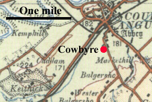 An
entry in the Rental Book (Vol. I, page 173, dated 1473)
refers to the building of a wooden bridge between Cowbyre
and Balgreschach, viz: "to help to mak a sufficiand
bryg of tre with laudstalis of stane bath for cart and
wayn." An
entry in the Rental Book (Vol. I, page 173, dated 1473)
refers to the building of a wooden bridge between Cowbyre
and Balgreschach, viz: "to help to mak a sufficiand
bryg of tre with laudstalis of stane bath for cart and
wayn."
Interpretation
Cowbyre is shown on early maps just south of the town.
Balgreschach (Balgersho) is about
one mile south of Coupar Angus. As Cowbyre was part
of Keithock (see Rental Index, Vol. II, page 329), the
bridge may have been over the Coupar Burn.
LITTLE
KEITHIK - DISPUTE WITH DUNFERMLINE ABBEY
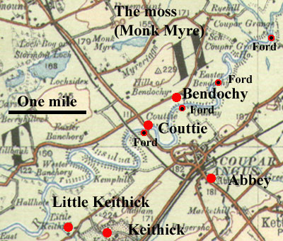 Easson,
Charters Vol. I, Charter XXXIII, pps 75-77, c.1221.
See also Dunfermline Register no.217. Easson,
Charters Vol. I, Charter XXXIII, pps 75-77, c.1221.
See also Dunfermline Register no.217.
A dispute had arisen between Dunfermline and Coupar
over land in Keithick (this was Little Keithick, granted
to Dunfermline by a bishop of Caithness - see Easson,
Vol. I, page 14) and the lands of Coupermaculty (Couttie)
and Bendochy which was also the property of Dunfermline.
The latter are just over the Isla from Coupar and Little
Keithick is on the south side of the Isla and adjacent
to Keithick which belonged to Coupar.
Due to their obstinacy in refusing
passage to the Coupar monks, Dunfermline lost Bendochy
and Coupirmaculty to Coupar (charter XXXII) but this
was later reversed and they retained these lands. As
part of the settlement, Dunfermline was to respect the
boundaries as existed before the dispute. The moss lying
between Blair, Couparmaculty and Bendochy was to remain
with Coupar and they were to have a road by land or
water to the peat moss without hinderance. However,
the men of Bendochy and Coupermaculty were to be allowed
to take 200 cartloads of peat from the moss each year.
Interpretation
The moss was probably the Monk's Mire and a straightforwardly
direct route can be assumed. The Isla may have been
crossed by fords at Couttie or Bendochy although a boat
could probably carry quite a load across the river
(see fords below).
DISPUTED MARCHES WITH SCONE
ABBEY NEAR COUPAR ANGUS
.Easson. Charters, Charter CXL, Vol.
II, page 57, dated 1466.
This document details the marches between Little Blare
held by Scone, and Coupirgrange and Mylhorn held by
Coupar. It also details the marches between Kynnochtry
(Scone) and Kethick (Coupar), and between Fothernys
(Scone) and Keithick and Balgersho (Coupar)
 |
| Parish boundary in green.
|
1.
Little Blare/Coupirgrange and Mylhorn
Although Little Blare appears on early maps, its location
other than being near Rosemount, is not clear. The boundary
starts at a blind well near Little Blare then follows
a ditch on its southern boundary underneath “Clunian
Hill”. This may be Rosemount which would fit the
description. The hill was probably to the north of our
boundary as a parish boundary (which may be our boundary)
runs along here joining the Monkmyre Burn at the eastern
end of the Monkmire loch. As the document refers to
reaching a Blackfurde with its rivulet, then running
to the Ericht and this forming the boundary between
Little Blare and Mylhorn we can be reasonably confident
that the Blackfurde is close to the east end of the
loch. The parish boundary, prior to the 1st edition
of the 6” map ran along the Monkmyre Burn but was
changed by the time of the 2nd edition c.1900 when it
turned north at this point to run along the track to
Wester Parkhead, possibly at the Blackfurde itself.
Interpretation
The track associated with the ford was probably of local
use only.
 |
| Road to Great Blare |
Marches
between Great Blare/Banquhory,
and Murehouse.
As the next charter CXLI (Easson, Charters, Vol.II,
page 64, dated 1466) is in much the same area we will
deal with it here. It concerns the marches between the
above places, the first two belonging to Scone and Murehouse
belonging to Coupar. The bounds read as follows:
Beginning firstly at the western
end of the little loch of Magna Blare called the Black
Loch and at the southern corner of the said loch near
the common road and where on the eastern side of the
same road a stone cross has been placed next to where
a large hole/pit has been made in the ground. And then
moving eastwards on the south side of the said little
loch by piles of stones and certain holes/pits divide
the said lands of Magna Blare which (belong) to the
said monastery of Scone on the north and the moor or.....here
the rest of the document is missing.
Interpretation
From the wording it seems clear enough that the road
ran between the White and Black Loch and probably ran
to Great Blare, the forerunner of Blairgowrie. It may
have come ultimately from Scone and have used the presumed
bridge over the Isla near to Cargill.
2.
Kynnochtry and Keithick
The next two sections appear quite straightforward but
in fact are very difficult to interpret. In both cases
it is likely that the parish boundaries (Coupar, Kettins
and Cargill) are being referred to, at least to a certain
extent, though it has to be noted that these have changed
over the years (see Ainslie 1794 and early 6" maps
for these - NLS
maps).
 |
| Part of Keithick. As it was
a grange there would have been links to the abbey. |
This section refers to a Redstanehalch
(haugh) between Kynnochtry (Scone) on the west and Kethick
(Coupar) on the east. The marches ran south to the summit
of the moor at a place called Carle from where they
went in a straight line to the east, with Kynnochtry
on the south of this line and Keithick on the north.
Once they reached a ford called the Murtone Nuke furde
they went east to another ford near the public road,
called the fovle ford (probably foul ford, i.e choked
with weeds).
Interpretation
With respect to Kynnochtry and Keithick, there is a
Redstone 2 miles SW of Kynnochtry but this seems too
far to be the Redstonehaugh of the charter; nor does
it fit the wording. More likely is the Coupar Burn at
Damhead or the Burrelton Burn but Carle and the two
fords are lost. It is likely however from what the next
section says that the Foulford was on the Kinnochtry
Burn and that the public road was near this.
 |
| Parish boundaries in green.
|
3.
Fothernys/Keithick and Balgersho
The charter has the marches proceed from the fovlefurde
northwards, descending as the waters of the same ford
run in the valley or rivulet called le qwhytle den dividing
Fothernys (Scone) on the east and the said lands of
Keithick (Coupar) on the west, and just as the rivulet
of that valley or water of the same descends to a certain
ford called Dundeisfurde and from there going north
and east by a certain marsh between the said lands of
Fothernys on the south side and the lands of Keithick
called le Kovtward (Coltward) on the north side to a
certain angle of the same marsh and from there ascending
to the Ruiche Reisk towards the south to the common
road and then ascending by the same road to a certain
spring called the blakhyll well, then ascending east
by a certain marsh vulgarly called fetgarrache which
divides Fothernys on the south side of the said marsh
and the lands of Balgersho (to Coupar) on the north
side of this marsh. And so finally proceeding as that
said marsh of fetgarrache extends to the torrent of
Fothernys and Balgersho. It says that numerous stone
crosses and piles of stone with coals (carbonibus) were
placed along the bounds.
Interpretation
With the Foulford being on the Kinnochtry Burn we can
follow this downstream to Lintrose which was formerly
called Fothernys (see Warden, Angus or Forfarshire,
Vol.IV,
page 19 - Foderance). The charter then beomes confusing
although Coltward and Balgersho are clear enough. The
Dundeisfurde suggests a route to Dundee but the route
shown on Edward's
map of 1678 through
Kettins and Newtyle seems too far north. Nor is it clear
where the common road might be.
GLENISLA
Rental, Vol. I, page 325, dated 1233.
Easson, Charters, Vol. I, XLI, Page 93
 |
| Glenisla. The abbey had several
farms here. |
 |
| Likely routes into
Glenisla |
In 1234 Alexander II confirmed
to the abbey by charter the lands of Glenylef and others,
to be held in free forest - Glenylif (Glenisla), Belactyn
(Bellaty), Frehqui (Freuchy), Cragneuithyn (Craignethan),
Innerchariadethi (Inverquharity), Fortuhy (Forter),
&c.
Also in 1234 he confirmed
that the monks would have (the use of) a certain road
by the middle of his forest of Alyth to their lands
of Glenylefe (Glenisla).
Rental, Vol. I, Page 327. Dated 1234.
John de Kinross
Rental, Vol.
I, page 173/174.
Easson, Charters, Vol. I, charters LXXVI & LXXVII,
pps 172 & 173.
In various charters he granted lands in Glenisla, viz.
Camboro (Camock), Duny, Clargis, Auchinlish. He also
granted the abbey free passage.
 |
 |
| An old
bridge in Alyth that would join up with the hill
track below. It is quite possible that it was constructed
by the abbey. |
Interpretation
 |
| Looking south along an old track
that leads to Alyth. To the north there would be
a direct route to Glenisla. |
The most direct route would be through
Alyth where there is an old
packhorse bridge (NMRS
record) and then over the Hill of Alyth by an old
track. This would lead directly to the Isla near Kilry
where there were probably two routes: one to serve the
lower, more easterly properties; and the other to serve
those higher up Glenisla. There is an interesting old
track just east of the modern road leading to Auchinleish
which terminates at stepping stones at Kirkton of Glenisla
but it first appears on the 1st edition of the 6"
map. Today's Cateran Trail runs through Cammock to Kirkton
of Glenisla and may link back to the mediaeval track.
CARSE OF GOWRIE
 |
| Carse of Gowrie |
Note: An overview of the grants
given by the Hay family can be found in the Rental,
Vol.I,
pages ix-xi.
Ederpoles
Gilbert of Hay, Grant of Ederpoles
Rental, Vol. II, page 286 & 290;
Easson, Charters, Vol. I, Charter XCIV, page 197
“By Gilbert of Hay, eldest son of David, the pastures
and fishings of Ederpoles, along with the mill and standing
and running waters on the lands, were confirmed to the
monks. Gilbert also gave them a common road through
his estates for their personal use, and for their cattle"
- see next item. (From Rental, Intro. Vol.1, page x).
Interpretation
Ederpoles has been identified as Carse Grange -
POMS. The likeliest route from here to the abbey
would have been through Inchture (see below) and up
past Abernyte to Ford of Pitcur.
Gilbert of Hay, Free Passage
Rental, Vol. II, page 289 & 285;
Easson, Charters, Vol.
I, Charter LXXXIII, page
181
This allows the abbey free passage over Gilbert's land.
He had previously given them the land of Ederpoles in
the Carse.
Baltrody
Rental, Vol. I, page 346
Sir Alexander of Abernethy, son of Sir Hugh, conferred
on the monastery twenty loads of peats, to be taken
yearly out of the moss of Baltrody. The peat was to
be taken to the Grange of Carse.
.Interpretation
A reasonably direct route between the petary and the
grange can be assumed.
Inchmartin
John of Inchmartyn grants free passage over his lands.
Easson, Charters, Vol. I, Charter LXXXIX, XC, Pages
192, 193; Rental Vol. I, page
Interpretation
Inchmartin is about two miles north of the grange. Presumably
it would make travel easier.
William de Fenton, Free Passage
Free passage granted by William de Fenton.
Easson, Charters, Vol. I, Charter XCI,
Page 194, dated 1307-17
Murehouse, Carse of Gowrie
Easson, Charters, Vol. I, Charter XLVII,
page 107-9
William de la Hay gave Coupar the land called Murhouse
lying south of the Grange of Carse and allowed free
entry and exit and pasture of his moor of Admure.
Easson says this is likely to be the same land
that had been granted by William de Haya in 1241 (see
XLII & XLVI) but had not been specified at that
time.
Interpretation
These are close to the grange and easily seen on the
map.
Causeway
Easson, Charters, Vol. I, Charter XXXVII,
page 83
In this charter, dating from c.1225, Richard
Kai allows for a causeway which the abbey was building
between Inchture and the Grange of Carse.
Interpretation
The Carse of Gowrie had always been marshy as evidenced
even as late as the time of the Statistical Accounts
when the roads were very poor. The names of Inchmartin,
Inchture, Inchcoonans etc indicate former islands. Presumably
the route to the grange was very marshy, hence the causeway.
There is no sign of the causeway today.
River Tay, Aithmuir
Easson, Charters, Vol. I, Charter LXXXII, page 179
 |
| Looking towards Dundee from
Polgavie and Athmuir |
In this charter, dating from around
1305, William of Haye granted the abbey space for two
cruives on the shore of the Tay. These were to lie between
his land of Athmoris and the land of Polgavy on the
one hand and the land of Randalfston on the other. Condition
were laid down as to how they were to be placed along
with his own cruives. In addition he gave free access
through his land of Athmoris to and from the cruives
and the Grange of Carse.
Interpretation
The places mentioned can be seen from the map.
Right of road between Polgavie
and Inchture
Rental, Vol. I,
Page 340
John Gifford of Polgavie gave them the right of a road
between Polgavie and Inchture, as follows:
Charter of donation by Johanis Gyffard of Polgauein
to God, Saint Marrise and the monks of Cupar that they
(might) have a way that extends by my land from the
bridge which is between my land of Polgavyn, and the
land of the same monks of Carso (the Carse), as far
as Inchethor (Inchture).
Interpretation
It is not known where the bridge was - it may have
been that mentioned in the next two charters but this
is not certain. Presumably a fairly straight route to
Inchture would be taken.
The following two references are
also of interest, viz:
Muirhouse
Rental, Vol. I, page 312, prob.1492 -
see no. 381, page 241 which mentions Andrew Jackson
Audro Jakson, Janot of Lorny, and Thorn Jakson, his
son, in
the murhous in the Browland of the Briggende of the
Carse Grange.
.Interpretation
Adair’s
map of 1685 has a Muirhouse and a bridge on the
road just south of the Grange.
Mill of Kersgrange
Rental, Vol. I, Page 241, no.381. Dated
1492
An
entry in the Rental refers to a grant of “our bog
myl within our
grange of the Kers, with the land multure, ryng beyr,
and all othir
pertinence. . . And alswa we haue set and grantit to
the said Pattoun
and Jonet, for all the dayis of thar lyftis, a ne auchtand
pairt of the
landis of our said Grange, lyand on the est halff be
sowth the gate,
next the said myll…..”
Interpretation
Adair’s map of 1685 shows the Perth to Dundee road
passing just to the north of the Bog Mill. The road
is on or close to the line of the present day minor
road.
LOUR
 |
| Lour. |
Hugo Abernethy gave the abbey
land in Lour beside the road leading from Forfar, viz:
Charter of donation by Heugonis Abernethy, knight, of
two acres of arable land in my territory of Lur in the
vndflate in the north side next to the public road which
leads from Forfar etc. 1273
Rental, Vol. I, Page 336
The two acres of land is referred to again in a confirmation
by Robert the Bruce of a grant of the “land of
Kincreik, within the barony of Lour, with the mill and
whole multure of the same barony; and also of two acres
of land on the north side of the Water of Kirbeth, between
the baronies of Innerichty and Lour," along with
free passage.
Rental, Vol. II, page 290, dated 1309
Two charters refer to a grant of a part of Lur where
the boundaries run from "the western side of the
great road which leads from Inverarethin to Forfar,
as far as the marches between Lur and mathin where a
certain spring arises and as the stream which issues
from that source falls into Gethin and as Gethin falls
into Kerbed...."
Rental Vol. I, page 344; Easson, Charters, Charters
X & XI, page 25
Interpretation
The map shows some of the places that can be identified.
From early maps it is likely that the road had much
the line of the older A929 road and very probably went
to Dundee, given the importance of Forfar and Dundee
in the early mediaeval period. There is some ambiguity
about it going through Inverarity - there may have been
a short branch from there or the meaning of the charter
may be that it passed through the lands of Inverarity
rather than the specific place.
A charter of Arbroath abbey (Dunnichen)
has a king's highway from Ochtirlony to Forfar but this
is too far distant to be the same as this road - see
here.
Coupar had a grange at Kincreich
which would entail a route to the abbey through Glamis
and Meigle (they had a right of free passage through
Meigle granted by Michael de Miggil - Easson, Charters,
Vol. I, Charter LXVIII, Page 190).
ATHOLL
 |
| There were early routes from
Perth and Dunkeld to Blair Atholl and also north
to Ruthven. While the Dunkeld route might have been
used, it would have been easier to float the timber
downstream. |
(From Rental, Intro.
vol.1, xv, xvi) “Among the earlier benefactors
of the abbey were members of the noble family of Athole.
Malcolm, second Earl of Athole, granted to the abbey,
from his forest of Athole, beams of timber for its construction.
To the monks, Cuming, son of Henry, third Earl of Athole,
granted the privilege of his woods at Glenherthry and
Tolikyne, which was confirmed by his son Eugenius.”
(The Scottish Peerage, The Celtic Earls of Athole, vol.
I, p.419 identifies these as Glenerrichdie and Tulloch
- Glen Errochty is 4 m west of Blair Atholl, Tulloch
is immediately south of Blair Atholl)
The shortest route to the abbey
would have been to Dunkeld and then by Capputh to Meiklour
where the Isla could be crossed. The timbers could have
been floated downriver which would have saved a great
deal of work.
ESTIR
DRYMNE - COMMON LONE
Rental, Volume II, pages 130 and 131
 |
| Drimmie. Parish
boundaries in green. The loan would have served
the two farms and would have been somewhere near
the Horse Stone or up towards Aldnecrecht |
These records, dating from 1553,
relate to the boundaries between Easter and Middle Drimmie
The boundaries are detailed as follows: "...that
is to say, to the burn betuix Ester Drymme and Middill
Drymme, begynand at Polcroster in the water of Arycht
and haldis to croft Newtok one that ane part and fra
the said croft Newtok northt vp to the myre, with commoun
pastour to the Halkstane; and fra that est to the Studystane;
and fra that to the burn callit Aldnecrecht, as ald
vse and wont wes; with the croft of land callit the
Well medow, lyand at the est fald, begynand at the burn
northt to the mos, as the said croft is devidit be carnis
of stanis; and fra the said croft of the Well medow,
with commune pastour, to ane vther croft besyde Wester
Drymme, callit the Owar hawcht, with commoun lonen fra
the said croft Newtok, northt vp to the mos and to the
Halkstane…"
Interpretation
The boundary starts
at the river Ericht and follows the burn separating
the two Drimmies up to the Hill of Drimmie. There is
a Horse Stone here that may be the Hawk Stone but in
any case a parish boundary runs north to the Burn of
Aldnacrecht, which could be an alternative location
for the Hawkstone. The other places are a little obscure
but are probably near Wester Drimmie. On this reading
the common loan would have run either from the upper
reaches of the burn dividing the two Drimmies to the
Hill Of Drimmie, or have gone north from here towards
Aldnecrecht. It was undoubtedly of local use only to
the farms involved.
LANDS OF
REEDIE AND AUCHINDORY - FREE PASSAGE
Rental, Vol. I, page 349, c.1300
 |
| Reedie from the south. A Roman
road is thought to run across the foreground of
this image. |
Two charters (88 & 89) of
William Fenton, soldier, gave firstly, the land of Adory
in the tenement of Rethy to the abbey and, secondly
the right of free passage to the abbey’s servants
(“Ane vther Carter of free passage to ye seruands
of ye saids monkes be Dominus Villielmus Fenton, miles,
the vittnes ane vith ye first").
Easson, Charters, Vol. I, Charter
XCIII is a confirmation by John Fenton, William’s
son, of the grant of Rethy and the free passage.
 |
| The sightings of
the Roman road are just south of Reedie and trend
from the SW to NE. There is a slight possibility
that it is the Scottisgait of an Arbroath charter. |
Interpretation
Adory is Auchindory, just south of Kirriemuir. Rethie
is nearby and is called Reedie. While it doesn't mention
any road, just free passage, it is of note that an Arbroath
charter dealing with much the same area talks of
a boundary running to "Achyndory and to the furd
of Dersy vest the greyn rod quhill it cum to the Scotisgait
and swa north to the Vynddy-yettis...." This places
the Scotisgait near Reedie which raises the possibility
that it is identical to the Roman road which was picked
up at Westmuir and ran close to Reedie (OGS Crawford,
Topography of Roman Scotland, page 90, NMRS
records). The NMRS records detail the possible line
of road passing near Reedie from Cardean (near Meigle)
to either Inverquharity (3 m north-east of Kirriemuir)
or Finavon (7 m east of Kirriemuir).
RIVER
FERRIES
Several river ferries are mentioned, as follows:
Boat of the Baitscheill. This ferry was just
north of the town, over the Isla. The name probably
applies to the dwelling of the boatman or the shed where
the boat was kept, although it is interesting to see
that it later became Beech Hill.
In a list of duties (Rental, Vol. I, page 256), the
boat man was to be “suet and gentill, and mak gud
seruice to al that cummys without strublans.”
Boat of Campsie e.g. Rental,
Vol. I, page 220. This was at the Abbot’s dwelling
and was for fishing rather than a ferry.
Boat of Isla. There are
many references to this - it is probably the same as
the Baitscheill boat.
On page xviii (Rental, Vol. II)
it says that tenants whose lands bordered on the Isla
or other rivers were generally required to maintain
a boat for the use of the monks.
Ly west bait de Wyndy Haige
(Rental, Vol. II, page 207). Unidentified. It appears
in a list of “other places” which are a considerable
distance from the abbey.
Midylbait (Rental, Vol.
I, page 278) - unidentified
FORDS
Cartfurde
Rental Book, Vol.I, page 248
This is referred to as follows:
..ffour acris of our burgh of Kethik, liand on the south
west side of the cawsay end, merchand with James Bernardis
land on the north side, togidder with the toft and zaird
liand on the south pairt of the cawsay, and James Bernardis
toft on the west pairt, and the land of the Gallaraw
on the est pairt, with the medow discendand fra the
toft til the cartfurde liand betwixt the land of the
Gallaraw on the est side, and the lands of Kethik on
the west pairt of the clay pottis, exceppand clay for
the nedis of our place, and of vthir tenandis that gettis
specials leif of vs in tyme cumyng . . [etc., as in
previous grants of Kethik; dated 12th May 1495].
Interpretation
From this description, the ford may be where the Bridge
of Couttie, built in 1766, now stands. This is an interesting
ford as there were two large boulders in its bed, one
called the “wading stone” and the other the
“riding stone.” No sign of these can be seen
today and the river looks both deep and dangerous at
this location.
 Less
likely is a ford near Bendochy church which was near
to Gallaraw (Galray, Gallery - Roy). Its depth of 3
feet at the best of times when the river could easily
increase in depth would make it of limited use. Both
Statistical Accounts for Bendochy parish mention the
ford (NSA, page 1180; OSA, Vol.19, page 355) noting
the Isla is 75 yards broad and 3 feet deep at the ford
with a “right of road to Coupar-Angus.” Less
likely is a ford near Bendochy church which was near
to Gallaraw (Galray, Gallery - Roy). Its depth of 3
feet at the best of times when the river could easily
increase in depth would make it of limited use. Both
Statistical Accounts for Bendochy parish mention the
ford (NSA, page 1180; OSA, Vol.19, page 355) noting
the Isla is 75 yards broad and 3 feet deep at the ford
with a “right of road to Coupar-Angus.”
Whatever the case, the abbey had
lands and granges on the north side of the Isla, and
these would have required a fording point to access
the abbey with grain and other produce.
Cowfurd
Rental Book, Vol. I, page 131
 |
| Parish boundaries
in green - from Stobie 1783 |
This gives the Marches between
Ester Cally or Monkis Cally, and Parsy and Myddil Cally
or Buttiris Cally as follows:
First beginning at Aldglew, thence ascending to Tulquhan,
afterwards towards the north as far as Laron, extending
to that place commonly called the Cowfurd ending on
the hill now called Soilzare Moir.
Interpretation
This boundary may start in Strathardle at Lagan-Dhu
where the nearby Aldnaigle Burn may derive from Aldglew.
A parish boundary runs north-eastwards from here and
the boundary may follow this to make its way over the
hills to Dalruzian which Pont has as Darryllon and Roy
has as Dalrillon. If this is Laron then the Cowford
must be on the Black Water just south of the still existing
Soilzarie. There are a couple of fords shown on the
old 6” map at this location, one of which may be
the Cowford, but it is not clear if they were used for
anything other than local movement.
Redfurdhalch
This appears in the Rental for 1463 (Vol. I, page 130)
under Balmyle which is less than a mile to the west
of Meigle. The wording is:
A tack to seven husbandmen for five years, paying yearly
12 chalders of meal and bear, 12 dozen hens, with six
score loads of peats. Also that piece of land called
Redfurdhauch is assigned to the same.
Interpretation
The place name is lost but it may have been on the River
Isla just to the north of Balmyle.
Other Fords
The 1st series of the 6" map shows some 7 fords
on the Isla and Ericht between Couttie and West Grange
of Aberbrothrie, about 5 miles upstream.
ALVAH, BANFFSHIRE
Easson, Charters, Vol. I, Page 201,
Charter XCV
This document relates to a gift of the church of Alvah,
in Banffshire, and its lands, by Marjory, widow of John,
Earl of Athole. It is treated under Mediaeval Charters:
Moray, here.
PERTH
The index (Rental, Vol. II, page 361) mentions the following:
Bridge, High-gate, Kirk-gate, North-gate, Skinner-gate,
Spey-gate.
DUNDEE
Rental, Vol. I, page 175, no.216
This refers to land in Dundee as follows:
the land lyand on the north half of the gate of the
castale burn and twa rudis of land lyand in the welgat…..
Dated 1474
GRANGES
 Granges
were an important part of the monastic economy. As well
as being large farms in their own right, they served as
collection points for produce from nearby farms prior
to being taken to the abbey. In the early days they were
run by lay brothers but later were leased out to individuals. Granges
were an important part of the monastic economy. As well
as being large farms in their own right, they served as
collection points for produce from nearby farms prior
to being taken to the abbey. In the early days they were
run by lay brothers but later were leased out to individuals.
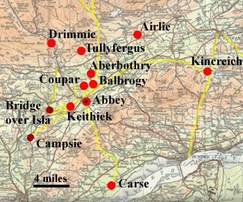
The abbey had nine granges in
the following places as marked on the map:
Aberbothry, Eroly (Airlie), Balbrogie, Grange of Kerso
(Carse Grange), Coupar Grange, Drimmie, Keithick, Kincreich,
Tullyfergus. Easson in Charters, Vol. I, pages xxxiii
& xxxiv gives an overview of the granges in the
early days of the abbey where they seem to have been
established as such by around 1300. There are numerous
later references to both granges and farms in the Rental.
We can generally assume movement
from outlying farms to a nearby grange and from a grange
to the abbey. In a number of cases the records specify
what materials or produce should be carried (see Rental
index vol. 2, p. 326). These include peat, sand, timber,
stone, coal, slates as well as fish and agricultural
produce such as grain and cheese.
As an example of the style in
which leases were written we can see one for Balbrogy
(which was required to carry items from Dundee), thus:
Wester Balbrogy - Rental, Vol.
II, page 47, dated 1547 - castin and
wynnyng of xxv fidderis of petis in our est myre of
Balbrogy,
or in ony vther moss or myre at we may obtene licence
for the
tyme, as we sail assigne to thame, and sail leid xij
fidderis and
ane half of thame to our place of Cowpar, with ane gret
draucht
with iiij oxin and tuay hors zerle to lyme, sclait,
colis, salt, or
tymmer, fra Dunde or vther placis, with ane male turss
of fodder;
and for thair teind of the samyn zerelie sail pay sex
bollis mele
and thre bollis bere gude and sufficient, with tuay
turss fodder,
with all vther . . . dewiteis and dew seruice, vse and
wont, . . . doand thair dewiteis lelelie and trewlie
to our
corn miln of Kethik…
Dundee was used as the port for
the abbey. In addition, fish was brought from Campsey
near to Perth, and from Montrose and other coastal towns
via Kincreich Grange.
Requirements as to which mill
should be used are noted in leases, and these can be
used to work out likely local routes. There were corn
and waulk (fulling) mills at Aberbothry, Balmyle, Blacklaw,
Brunty, Cally, Carse Grange, Cupar Grange, Drimmie,
Glenisla, Keithock, Kincreich, Ledcassy, Lundie, Milnhorn,
and Syks.
Top
|

